


Search for another town


Free U.S. delivery 7 to 10 days after you order
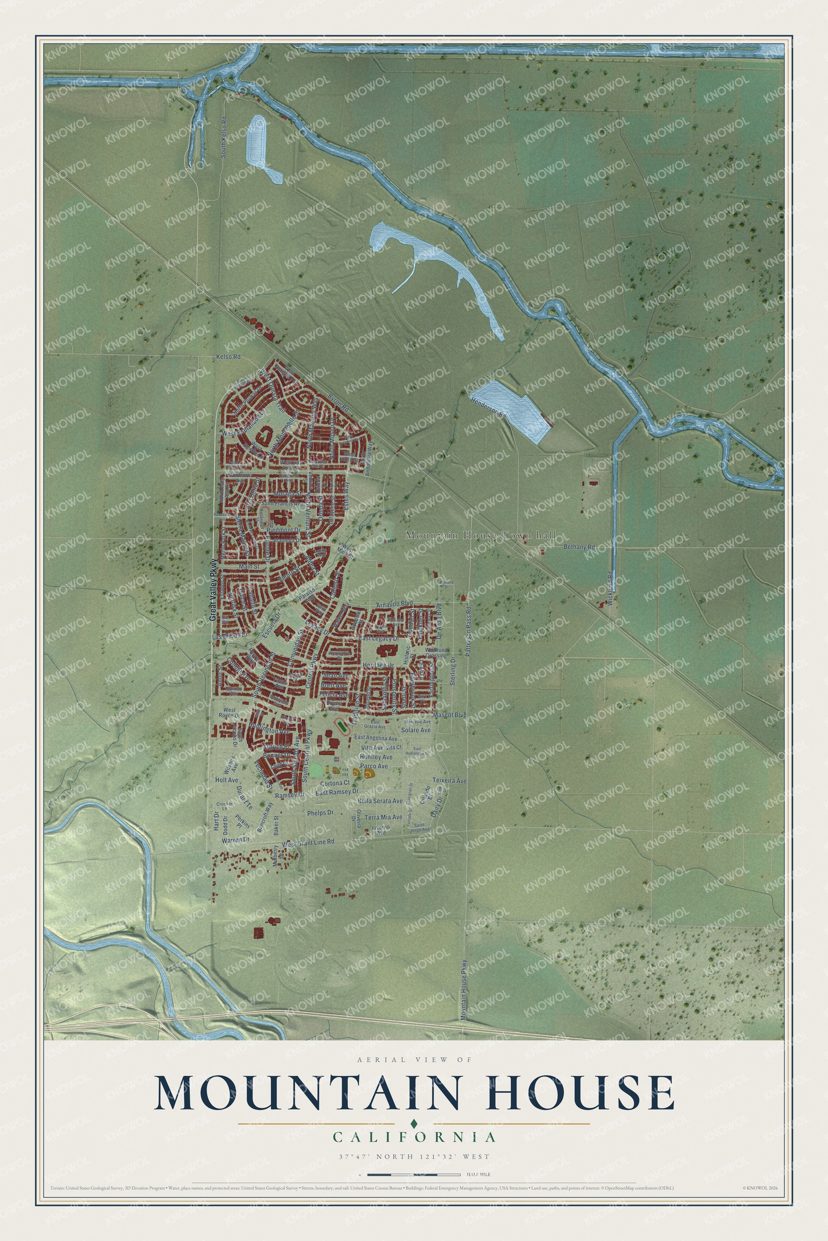
Mountain House, California Map Art
Building by building, with labeled streets and shaded relief.
12" x 18" Archival Matte Print
A Map of Home. A Work of Art.
Explore Mountain House, California from a whole new perspective. Created using aerial imagery and detailed geographic data, this map captures Mountain House building by building, with labeled streets, familiar landmarks, and shaded topographical relief that highlights the natural contours of the landscape.
Combining modern data with the timeless character of a vintage atlas, this map is just as interesting up close as it is beautiful on the wall. Whether you grew up in Mountain House, spent memorable years there, or call it home today, this unique map is a great way to celebrate a place that means something to you. Zoom in on the preview to look for your street, and then order a print to put your memories on the wall.
Three ways to hang it

Unframed archival matte, a black wood frame or a white wood frame.
Up close
Geography Worth Displaying
This map was created using accurate cartographic data and authoritative geographic sources, including the U.S. Geological Survey and the Census Bureau. The map brings together terrain, waterways, roads, and building detail. The majority of the streets are labeled, houses are accurately depicted, and the topography is derived from government sources. Combining local data with carefully composed color and shading leads to this beautifully detailed Mountain House artwork for your wall.
Rather than simply showing street outlines, we’ve included as many of the street names as we could reasonably fit on the map while keeping their names legible. Zoom in on the high resolution preview to see exactly what’s on the map. We truly set out to create a statement piece for anyone who loves Mountain House. So whether it’s for you, or a gift for someone you love, we hope this map of Mountain House brings back fond memories.
Read the story behind this map of Mountain House, California from 2026.

Find your street
Names on the Mountain House map
Every name below is printed on this map. Look for your street, your school, the park where you played, or the pond down the road.
Places and landmarks1
- Mountain House Town hall
Streets and roads148
- Great Valley Parkway
- North Marquis Way
- North Ventura Street
- South Vecindad Street
- Ellerbrook Street
- Farrington Street
- Alta Dena Street
- Vecindad Street
- Piedmont Drive
- Dairy Drive
- Warren Drive
- East Legacy Drive
- Kelso Road
- Orinda Street
- Hart Drive
- Puente Drive
- Ramsey Drive
- Holt Avenue
- West Questa Trail
- Heritage Drive
- Estes Way
- Shelli Street
- De Anza Boulevard
- Sterling Drive
- Aldea Street
- Sean Avenue
- Durant Te
- Brett Avenue
- South Central Parkway
- Legacy Drive
Show all 148 streets
- Mountain House Parkway
- Patterson Pass Road
- Byron Road
- West Grant Line Road
- Central Parkway
- Tradition Street
- Mascot Boulevard
- Henderson Road
- South Kelso Road
- Prosperity Street
- Main Street
- Arnaudo Boulevard
- Las Brisas Drive
- West Esplanade Drive
- Curioso Street
- Phelps Drive
- Escuela Drive
- North Montebello Street
- East Ramsey Drive
- Bethany Road
- Moraga Street
- Viento Street
- Sierra Madre Street
- Comunidad Street
- Conejo Avenue
- Wicklund Road
- South Shields Avenue
- Teixeira Avenue
- Aldrich Place
- Sonrisa Street
- Parco Avenue
- North Museo Drive
- Bella Serata Avenue
- Dulce Street
- Huntington Avenue
- Caballo Street
- Terra Mia Avenue
- Huntley Avenue
- Bonner Drive
- Cortona Court
- Felicia Avenue
- Samantha Street
- Faulkner Street
- Solare Avenue
- Goodall Street
- Amor Street
- Vita Avenue
- Ventura Street
- Lafayette Street
- Historic Street
- Menlo Park Street
- Le Ah Lane
- West Main Street
- North Palo Alto Street
- Estados Street
- Bryant Avenue
- Joseph Street
- Walker Way
- Wilshire Avenue
- North Plumas Drive
- Fauna Avenue
- Wicklund Crossing
- Alameda Drive
- Recreo Way
- Bancroft Way
- East Angelina Avenue
- Saint Francis Avenue
- North Andalusia Way
- South Jacobs Drive
- West Amelia Lane
- West Antigua Terrace
- Montecito Avenue
- Paraiso Way
- West Royce Drive
- Mulberry Lane
- Perkins Place
- Goodwin Street
- West Viola Street
- Orlando Bl
- Ladd Drive
- West San Juan Drive
- Dodd Drive
- Oliveira Drive
- Baker Street
- Liverno Avenue
- Orinda Court
- Vita Court
- Rockridge Street
- Saint Jorge Avenue
- East Grazia Avenue
- Camarada Avenue
- Marcello Avenue
- Burk Place
- Corazon Way
- Cupertino Avenue
- Hatheway Street
- Alexandria Drive
- Gallo Way
- Lucita Way
- Crocker Lane
- McLeod Avenue
- Recreo Court
- North Alta Dena Street
- Kinross Way
- Furtado Gl
- West Jardin Terrace
- Cordes Avenue
- West Aventino Avenue
- Olson Avenue
- Pasadena Avenue
- West Santa Clara Drive
- Sauvignon Street
- Fulton Street
- East Hydrangea Gl
- Lafayette Court
- Rico Way
- Ventura Drive
- Cow Court
Names are listed as they appear on the printed map. Zoom into the product photos to find them.
About Mountain House, California
Mountain House is a city of 24,499 people on the western edge of San Joaquin County, at the foot of the Diablo Range near Altamont Pass. The Northern Valley Yokuts lived here first. In 1849 Thomas Goodall set up a blue denim tent where gold miners bound from San Francisco for the Sierra foothills could rest halfway. He later built an adobe at the edge of the hills and named it The Mountain House. Simon Zimmerman took it over, and Zimmerman's Mountain House became a famous stop on the road to Stockton. Its last buildings came down in 1940.
The modern city began as a plan. County supervisors approved it on November 10, 1994, Trimark broke ground on May 14, 2001, and the first home foundation was poured on January 18, 2003. Each of its 12 planned neighborhoods was to center on a park, a K-8 school and a few shops. On March 5, 2024, more than 90% of voters chose to incorporate, and Mountain House became the county's 8th city on July 1, 2024, with a celebration on July 4.
- Underwater in 2008In November 2008 The New York Times named Mountain House the most underwater community in America. About 90% of its homes were worth less than what their owners owed, the average homeowner was reported $122,000 in debt, and local shops closed as families cut back. Growth slowed during the recession, but building picked up again in 2010 and 2011, and by April 2012 the trade magazine Big Builder was reporting stronger sales.
- An American Idol recordIn January 2011, Thia Megia, a 15-year-old from Mountain House, became the youngest finalist in the history of American Idol.
- Mustangs since 2014Students here once went to Tracy for high school. Voters made Lammersville a unified district on June 8, 2010, work on Mountain House High School began in July 2012, and the school opened in August 2014. Its teams are the Mustangs, in royal and silver.
- The first city leadersThe 2024 election that created the city also chose its first leaders. Dr. Andy Su became the first mayor, and Bernice Tingle, Matt Disko, Ronna Green and Dan Harrision took the first seats on the council. Steve Pinkerton became the first city manager, working from the Town Hall and Library that opened in March 2020.
Keep exploring California
Mountain House is one of 1,990 California towns we've mapped. Every dot on the map is a print of its own.
The search covers every state, California first.
Near Mountain House
Order 2 or more town maps and save 10%. Shown in the size and finish you picked above, so they hang as a set.
- Tracy 12" x 18" / Archival Matte Print $39.99
- Altamont 12" x 18" / Archival Matte Print $39.99
- Byron 12" x 18" / Archival Matte Print $39.99


More maps nearby: Banta, Discovery Bay, Lathrop, Livermore and Knightsen.
The art of mapping a place
How This Map Was Made
Real places. Remarkable detail. Discover the layers that turn geographic data into a map of home.

The view from above
Aerial imagery reveals the character of the land: woodland, open fields, and the patterns of a place.

The shape of the land
Elevation data brings hills, valleys, and subtle changes in the landscape into view.

The details of home
Roads, waterways, and building footprints come together to make the map feel unmistakably local.

Geography becomes art
Considered color, shading, and typography bring the layers together in a map made for your wall.


Process illustrated with Mendon, Massachusetts. Aerial imagery: USDA NAIP. Terrain: USGS 3D Elevation Program. Map details and finished artwork: KNOWOL.
The Details
About This Print
Choose an archival matte print, or a black or white Ayous wood frame. The archival matte print is unframed.
Select your size and finish above to see the matching product image and price.
Materials & Craftsmanship
A contemporary map with the character of a classic atlas, printed on archival matte paper. Optional frames are made from Ayous wood.
Your printed map does not include the watermark shown in the full-map preview.
Shipping & Delivery
Free shipping within the United States. Every print is made to order in the USA.
Buying a gift? Add a note in your cart and we'll include it. We never put prices in the package.
Prints ship within 2 to 3 business days. Allow 7 to 10 days total from ordering for delivery. Timing may vary during holidays or periods of high order volume.
Read our shipping policy.
Returns and damaged prints
Each print is made to order. Change-of-mind refunds are not available after production.
If your print arrives damaged, misprinted or incorrect, contact support@knowol.com within 30 days of receiving it. Include your order number, photos and a description of the issue.
Read our full refund and replacement policy. For questions about your order, email support@knowol.com.