


Search for another town


Free U.S. delivery 7 to 10 days after you order
Tracy, California Map Art
Building by building, with labeled streets and shaded relief.
12" x 18" Archival Matte Print
A Map of Home. A Work of Art.
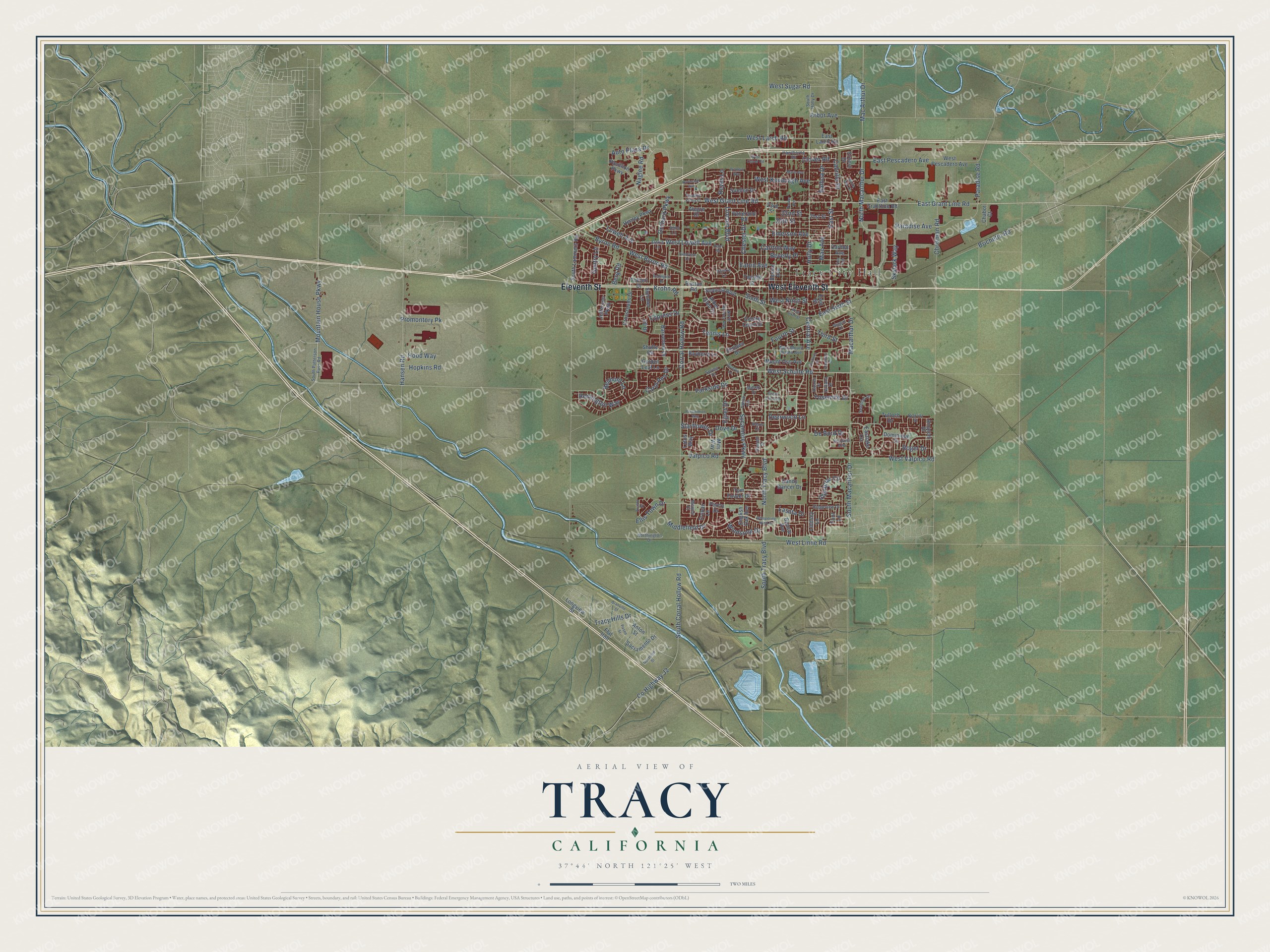
Explore Tracy, California from a whole new perspective. Created using aerial imagery and detailed geographic data, this map captures Tracy building by building, with labeled streets, familiar landmarks, and shaded topographical relief that highlights the natural contours of the landscape.
Combining modern data with the timeless character of a vintage atlas, this map is just as interesting up close as it is beautiful on the wall. Whether you grew up in Tracy, spent memorable years there, or call it home today, this unique map is a great way to celebrate a place that means something to you. Zoom in on the preview to look for your street, and then order a print to put your memories on the wall.
Three ways to hang it

Unframed archival matte, a black wood frame or a white wood frame.
Up close
Geography Worth Displaying
This map was created using accurate cartographic data and authoritative geographic sources, including the U.S. Geological Survey and the Census Bureau. The map brings together terrain, waterways, roads, and building detail. The majority of the streets are labeled, houses are accurately depicted, and the topography is derived from government sources. Combining local data with carefully composed color and shading leads to this beautifully detailed Tracy artwork for your wall.
Rather than simply showing street outlines, we’ve included as many of the street names as we could reasonably fit on the map while keeping their names legible. Zoom in on the high resolution preview to see exactly what’s on the map. We truly set out to create a statement piece for anyone who loves Tracy. So whether it’s for you, or a gift for someone you love, we hope this map of Tracy brings back fond memories.
Read the story behind this map of Tracy, California from 2026.

Find your street
Names on the Tracy map
Every name below is printed on this map. Look for your street, your school, the park where you played, or the pond down the road.
Places and landmarks1
- Tracy City Hall
Streets and roads176
- West Eleventh Street
- Eleventh Street
- East Grant Line Road
- West Lowell Avenue
- Mountain House Parkway
- Lowell Avenue
- Cabrillo Drive
- Auto Plaza Drive
- Mac Arthur Drive
- East Street
- Deerwood Lane
- West Grant Line Road
- Clover Road
- West Byron Road
- Holly Drive
- Byron Road
- Roger Drive
- Orchard Parkway
- Macarthur Drive
- 20th Street
- North Tracy Boulevard
- West Schulte Road
- Corral Hollow Road
- North Macarthur Drive
- Central Avenue
- South Corral Hollow Road
- Sycamore Parkway
- Tennis Lane
- Lincoln Boulevard
- West Valpico Road
Show all 176 streets
- County Highway J2
- Naglee Road
- South Tracy Boulevard
- Valpico Road
- South Macarthur Drive
- Tracy Hills Drive
- West Linne Road
- West Kavanagh Avenue
- Beverly Place
- Glenbriar Circle
- Hansen Road
- Eaton Avenue
- East Pescadero Avenue
- Brichetto Road
- West Larch Road
- Arbor Avenue
- Hopkins Road
- Skylark Way
- Third Street
- Cypress Drive
- Middlefield Drive
- Paradise Road
- 22nd Street
- Windsong Drive
- Promontory Pk
- Emerson Avenue
- Parkside Drive
- West Ninth Street
- Sixth Street
- Chrisman Road
- Chester Drive
- Fourth Street
- East Sixth Street
- Ellis Town Drive
- Remington Way
- Yosemite Drive
- Carlton Way
- Carol Ann Drive
- Belmont Lane
- De Bord Drive
- Mae Avenue
- Paradise Avenue
- West Sugar Road
- Starflower Drive
- Hood Way
- Berg Road
- Reyes Lane
- Balboa Drive
- Dove Drive
- Krohn Road
- Egret Drive
- Lasata Drive
- Gentry Lane
- Centre Court Drive
- East Grantline Road
- Alegre Drive
- Sequoia Boulevard
- Tom Fowler Drive
- Gandy Dancer Drive
- Peony Drive
- Renown Drive
- Lindsey Lane
- Golden Leaf Lane
- Alder Glen Drive
- Amatchi Drive
- Longview Street
- Bonsai Avenue
- Flat Iron
- South Lammers Road
- Twelfth Street
- Crossroads Drive
- Eastlake Circle
- Bessle Avenue
- Henley Parkway
- 21st Street
- Barcelona Drive
- West Pescadero Avenue
- Vallerand Road
- Pavillion Parkway
- Mount Oso Avenue
- Summer Lane
- 23rd Street
- Sacramento Drive
- English Oak Avenue
- Jefferson Parkway
- Lotus Way
- Tropaz Lane
- Bayberry Lane
- Anton Street
- Suellen Drive
- Dominique Drive
- East Larch Road
- Carlton Avenue
- Tulloch Drive
- Shulte Road
- Rustan Road
- Chabot Court
- Mits Way
- Tolbert Drive
- Flint Lane
- Ernest Drive
- Jill Drive
- Russell Street
- Alexis Lane
- Sultana Drive
- South Patterson Pass Road
- Tahoe Circle
- West Mount Diablo Avenue
- North Hickory Avenue
- Ridgeview Drive
- South Holly Drive
- Northington Drive
- Hawthorne Road
- Sentinel Drive
- Menay Drive
- Jenni Lane
- Ventana Avenue
- Biarritz Street
- Memoir Court
- Valerie Lane
- Iberis Court
- Spring Court
- Whispering Wind Drive
- White Oak Drive
- Parker Avenue
- Avalon Street
- Kavanagh Avenue
- Fieldview Drive
- West Sixth Street
- Paseo Street
- Persimmon Way
- Wagtail Drive
- Redington Drive
- Granville Street
- West Clover Road
- Marie Avenue
- Kapareil Drive
- Buena Tierra Drive
- Pacheco Drive
- Dolores Lane
- Iverstone Street
- Paradise Valley Court
- Altamont Drive
- Dronero Way
- Rehn Road
- Fine Avenue
Names are listed as they appear on the printed map. Zoom into the product photos to find them.
About Tracy, California
Tracy is a city of 93,000 people in San Joaquin County, in California's Central Valley. Bands of Yokuts lived here for generations, hunting game and fishing in the rivers and creeks, until Spanish labor demands, new diseases and later Mexican and American arrivals pushed them out. The city began as a railroad town. Starting in 1868, crews made up mostly of Chinese workers laid Central Pacific track from Sacramento through Stockton toward the Bay Area, and small towns grew up at the stations.
The work ended in September 1878, when a new branch and junction opened. The settlement at that junction was named for J. J. Tracy, a director of the railroad. Tracy was incorporated in 1911 and grew quickly as the trading center for the farms around it. It kept prospering even after the railroad cut back its operations in the 1950s.
“First known sail launch to ascend San Joaquin River from San Francisco landed here autumn, 1846.”
- A new city hall in 1900After the first city hall and jail burned down, the city ordered a new one late in 1899, and it was finished in March 1900. J.F. Hoerl built the plain brick building, 24 by 43 feet, at 25 West Seventh Street. It housed the city government in Tracy's early years and was one of only fourteen buildings rated exceptional in the city's historical resources inventory.
- The Tracy Inn of 1927The Tracy Inn opened in 1927 at 24 West Eleventh Street, with 60 rooms on the second floor. The Oakland firm of Slocomhe and Tuttle designed it in a blend of Spanish Colonial Revival and modern styles. Its sign was replaced in 1945. A fire in 1949, after a change of owners, destroyed the only original blueprints, but the owner still brought back the building's first look.
- A supply depot since 1942The Tracy Defense Distribution Depot opened in 1942 and has supplied American troops in every major war since World War II. With around 30 warehouses, it ranks among the area's largest employers, behind only Safeway.
Keep exploring California
Tracy is one of 1,990 California towns we've mapped. Every dot on the map is a print of its own.
The search covers every state, California first.
Near Tracy
Order 2 or more town maps and save 10%. Shown in the size and finish you picked above, so they hang as a set.
- Banta 12" x 18" / Archival Matte Print $39.99
- Mountain House 12" x 18" / Archival Matte Print $39.99
- Lathrop 12" x 18" / Archival Matte Print $39.99


More maps nearby: Altamont, Manteca, French Camp, Byron and Discovery Bay.
The art of mapping a place
How This Map Was Made
Real places. Remarkable detail. Discover the layers that turn geographic data into a map of home.

The view from above
Aerial imagery reveals the character of the land: woodland, open fields, and the patterns of a place.

The shape of the land
Elevation data brings hills, valleys, and subtle changes in the landscape into view.

The details of home
Roads, waterways, and building footprints come together to make the map feel unmistakably local.

Geography becomes art
Considered color, shading, and typography bring the layers together in a map made for your wall.


Process illustrated with Mendon, Massachusetts. Aerial imagery: USDA NAIP. Terrain: USGS 3D Elevation Program. Map details and finished artwork: KNOWOL.
The Details
About This Print
Choose an archival matte print, or a black or white Ayous wood frame. The archival matte print is unframed.
Select your size and finish above to see the matching product image and price.
Materials & Craftsmanship
A contemporary map with the character of a classic atlas, printed on archival matte paper. Optional frames are made from Ayous wood.
Your printed map does not include the watermark shown in the full-map preview.
Shipping & Delivery
Free shipping within the United States. Every print is made to order in the USA.
Buying a gift? Add a note in your cart and we'll include it. We never put prices in the package.
Prints ship within 2 to 3 business days. Allow 7 to 10 days total from ordering for delivery. Timing may vary during holidays or periods of high order volume.
Read our shipping policy.
Returns and damaged prints
Each print is made to order. Change-of-mind refunds are not available after production.
If your print arrives damaged, misprinted or incorrect, contact support@knowol.com within 30 days of receiving it. Include your order number, photos and a description of the issue.
Read our full refund and replacement policy. For questions about your order, email support@knowol.com.