
Search for another town


Free U.S. delivery 7 to 10 days after you order
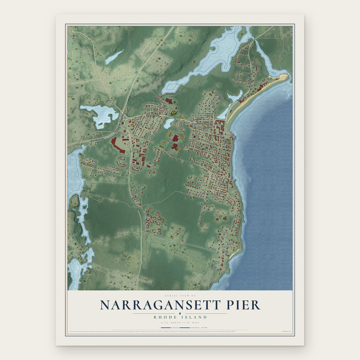
Narragansett Pier, Rhode Island Map Art
Building by building, with labeled streets and shaded relief.
12" x 18" Archival Matte Print
A Map of Home. A Work of Art.
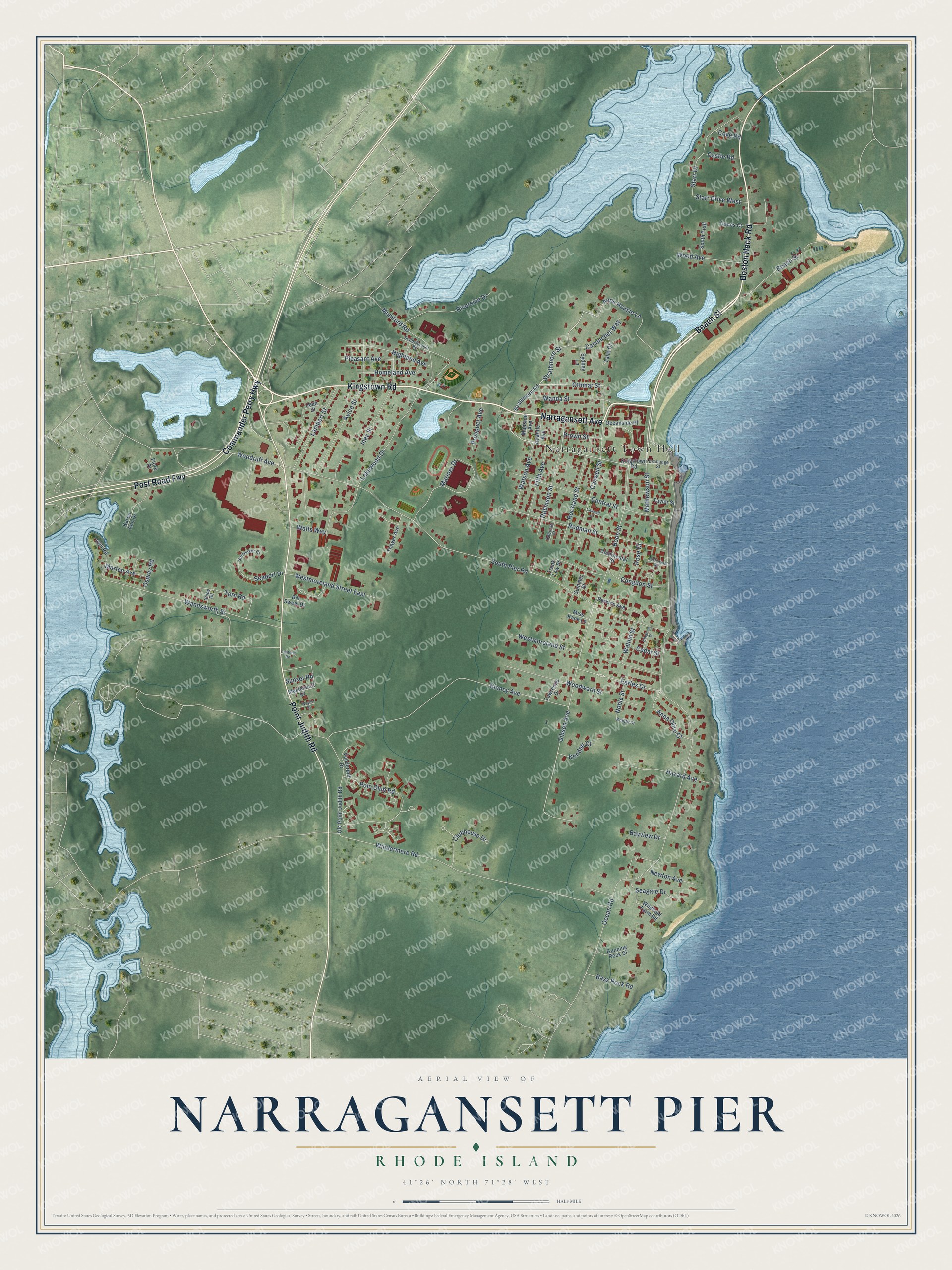
Explore Narragansett Pier, Rhode Island from a whole new perspective. Created using aerial imagery and detailed geographic data, this map captures Narragansett Pier building by building, with labeled streets, familiar landmarks, and shaded topographical relief that highlights the natural contours of the landscape.
Combining modern data with the timeless character of a vintage atlas, this map is just as interesting up close as it is beautiful on the wall. Whether you grew up in Narragansett Pier, spent memorable years there, or call it home today, this unique map is a great way to celebrate a place that means something to you. Zoom in on the preview to look for your street, and then order a print to put your memories on the wall.
Three ways to hang it

Unframed archival matte, a black wood frame or a white wood frame.
Up close
Geography Worth Displaying
This map was created using accurate cartographic data and authoritative geographic sources, including the U.S. Geological Survey and the Census Bureau. The map brings together terrain, waterways, roads, and building detail. The majority of the streets are labeled, houses are accurately depicted, and the topography is derived from government sources. Combining local data with carefully composed color and shading leads to this beautifully detailed Narragansett Pier artwork for your wall.
Rather than simply showing street outlines, we’ve included as many of the street names as we could reasonably fit on the map while keeping their names legible. Zoom in on the high resolution preview to see exactly what’s on the map. We truly set out to create a statement piece for anyone who loves Narragansett Pier. So whether it’s for you, or a gift for someone you love, we hope this map of Narragansett Pier brings back fond memories.
Read the story behind this map of Narragansett Pier, Rhode Island from 2026.

Find your street
Names on the Narragansett Pier map
Every name below is printed on this map. Look for your street, your school, the park where you played, or the pond down the road.
Places and landmarks1
- Narragansett Town Hall
Streets and roads106
- Kingstown Road
- Narragansett Avenue
- Boston Neck Road
- Commander Perry Highway
- Post Road Fwy
- Point Judith Road
- Beach Street
- Strathmore Street
- Othmar Street
- Boon Street
- Gibson Avenue
- Earles Court
- Woodruff Avenue
- Caswell Street
- Polo Club Road
- Ocean Road
- South Pier Road
- Windermere Road
- Kinney Avenue
- Wandsworth Street
- Rodman Street
- Central Street
- Mariner Drive
- Avice Street
- Westmoreland Street
- Robinson Street
- Anne Hoxsie Lane
- Congdon Street
- Lakewood Drive
- Mumford Road
Show all 106 streets
- Starr Drive
- Woodward Street
- Walts Way
- Inez Street
- Riverside Drive
- Lambert Street
- Westmoreland Street East
- Hazard Avenue
- Highland Avenue
- Wanda Street
- Rockland Street
- Fifth Avenue
- Clubhouse Drive
- Tern Road
- Anna Olivo Court
- Watson Avenue
- Homeland Avenue
- Wood Avenue
- Canonchet Way
- Bayview Drive
- Seaport Drive
- Starr Drive West
- Pleasant Avenue
- Mathewson Street
- Newton Avenue
- Prospect Avenue
- Bass Rock Road
- Seagate Drive
- Marten Avenue
- Kendall Court
- Walnut Street
- Rose Court
- Brown Street
- Noble Street
- Castle Road
- Cedar Street
- Ospray Road
- Sunset Road
- Cove Road
- Strathmore Road
- Old Point Judith Road
- Maplehurst Drive
- Thayer Avenue
- Wildfield Farm Road
- Karen Ann Drive
- Continental Street
- Oceanside Place
- Gull Road
- Vanderbilt Drive
- South Trail
- Jean Street
- Gunning Rock Drive
- Perkins Avenue
- Talia Court
- Dunes Court
- Atlantic Avenue
- Taylor Street
- Mansion Avenue
- Summer Street
- Sydney Lane
- Lawrence Drive
- Fiore Drive
- Bill Sweet Drive
- Miss Kane Lane
- Frank Low Street
- Schoolhouse Road
- Spinnaker Court
- Exchange Street
- Deborah Street
- Snipe Road
- Knight Street
- Chestnut Street
- Continental Road
- Wayne Street
- Cantone Road
- Caswell Court
Names are listed as they appear on the printed map. Zoom into the product photos to find them.
About Narragansett Pier, Rhode Island
Narragansett Pier is a village of 3,308 people in the town of Narragansett, in Washington County. The village is named for a pier that went up in 1781 at its center, beside the spot where The Towers now stand. Farms here were known in those years for cheese, sheep, grain and the Narragansett Pacer horses, and boats carried those goods out across Narragansett Bay.
Its life as a resort started in 1848. That year Joseph Heatly Dulles of Philadelphia saw the beach and liked it so much that he booked all the rooms in the little boarding house kept by Benjamin Hadwen for the following summer, and he kept returning each year after that. In 1856 Ezbon S. Taylor opened the village's first real hotel, the Narragansett House.
- The darkest day, 1900On September 12, 1900, a fire broke out in the huge Rockingham Hotel and spread to the Narragansett Pier Casino, which was destroyed. Only the granite walls of the casino's grand archway survived, and those walls are The Towers. In 1905 a new casino, again designed by McKim, Mead and White, rose on the ground where the Rockingham had stood.
- A secretary of state's ancestorJoseph Heatly Dulles, whose yearly visits with family and friends launched the resort, was the great-grandfather of John Foster Dulles. The younger Dulles went on to serve as secretary of state under President Eisenhower.
- The Davis family summersVarina Davis, the former First Lady of the Confederacy, spent summers at the Pier after she was widowed in the 1890s. Her youngest daughter, Varina Anne Davis, known as the "Daughter of the Confederacy," came with her and died here on September 18, 1898, at 34.
Keep exploring Rhode Island
Narragansett Pier is one of 86 Rhode Island towns we've mapped. Every dot on the map is a print of its own.
The search covers every state, Rhode Island first.
Near Narragansett Pier
Order 2 or more town maps and save 10%. Shown in the size and finish you picked above, so they hang as a set.
- Wakefield-Peace Dale 12" x 18" / Archival Matte Print $39.99
- Narragansett 12" x 18" / Archival Matte Print $39.99
- South Kingstown 12" x 18" / Archival Matte Print $39.99


More maps nearby: Kingston, Matunuck, Hamilton, Jamestown and Newport.
The art of mapping a place
How This Map Was Made
Real places. Remarkable detail. Discover the layers that turn geographic data into a map of home.

The view from above
Aerial imagery reveals the character of the land: woodland, open fields, and the patterns of a place.

The shape of the land
Elevation data brings hills, valleys, and subtle changes in the landscape into view.

The details of home
Roads, waterways, and building footprints come together to make the map feel unmistakably local.

Geography becomes art
Considered color, shading, and typography bring the layers together in a map made for your wall.


Process illustrated with Mendon, Massachusetts. Aerial imagery: USDA NAIP. Terrain: USGS 3D Elevation Program. Map details and finished artwork: KNOWOL.
The Details
About This Print
Choose an archival matte print, or a black or white Ayous wood frame. The archival matte print is unframed.
Select your size and finish above to see the matching product image and price.
Materials & Craftsmanship
A contemporary map with the character of a classic atlas, printed on archival matte paper. Optional frames are made from Ayous wood.
Your printed map does not include the watermark shown in the full-map preview.
Shipping & Delivery
Free shipping within the United States. Every print is made to order in the USA.
Buying a gift? Add a note in your cart and we'll include it. We never put prices in the package.
Prints ship within 2 to 3 business days. Allow 7 to 10 days total from ordering for delivery. Timing may vary during holidays or periods of high order volume.
Read our shipping policy.
Returns and damaged prints
Each print is made to order. Change-of-mind refunds are not available after production.
If your print arrives damaged, misprinted or incorrect, contact support@knowol.com within 30 days of receiving it. Include your order number, photos and a description of the issue.
Read our full refund and replacement policy. For questions about your order, email support@knowol.com.