


Search for another town


Free U.S. delivery 7 to 10 days after you order
South Kingstown, Rhode Island Map Art
Building by building, with labeled streets and shaded relief.
12" x 18" Archival Matte Print
A Map of Home. A Work of Art.
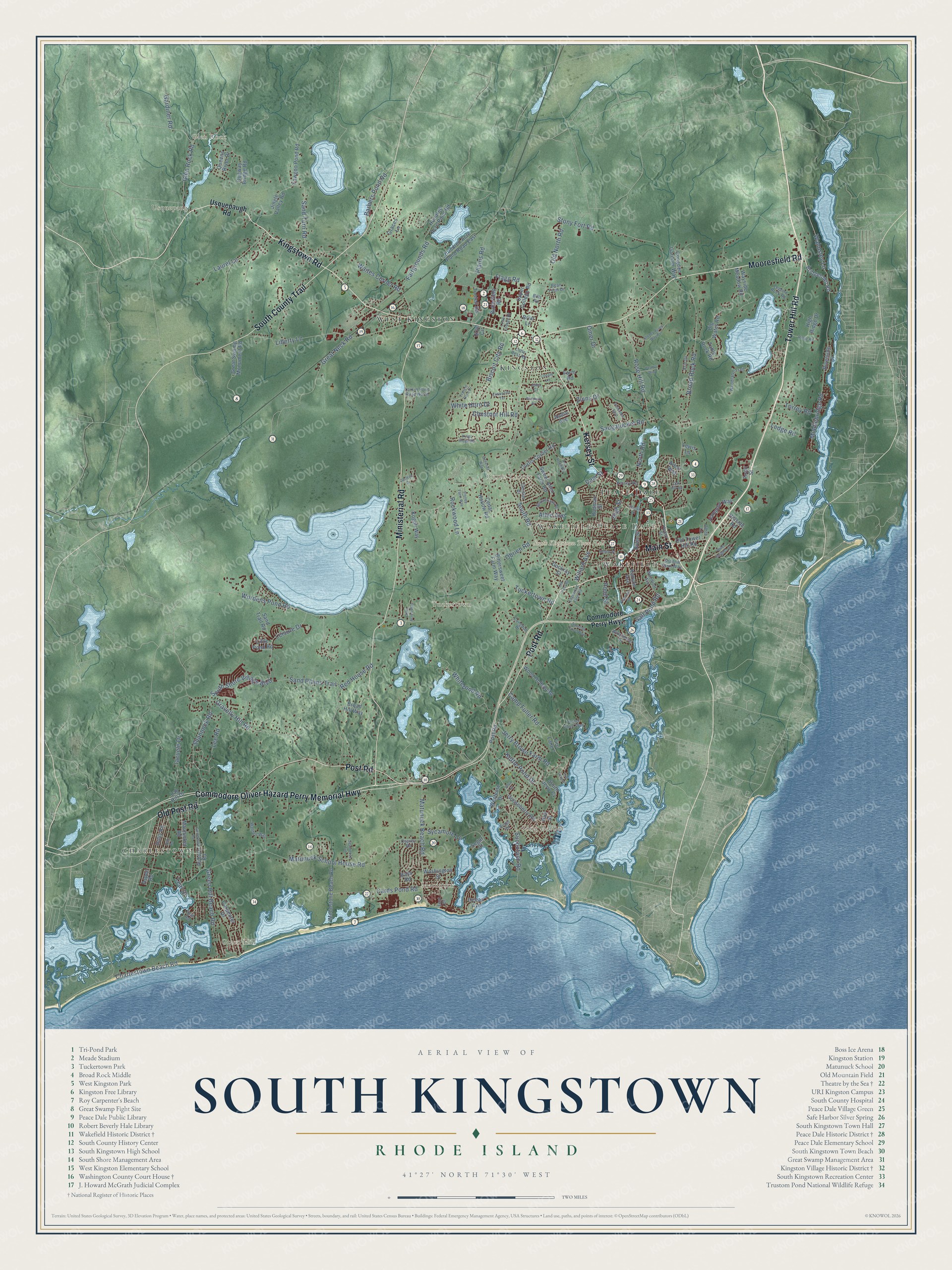
Explore South Kingstown, Rhode Island from a whole new perspective. Created using aerial imagery and detailed geographic data, this map captures South Kingstown building by building, with labeled streets, familiar landmarks, and shaded topographical relief that highlights the natural contours of the landscape.
Combining modern data with the timeless character of a vintage atlas, this map is just as interesting up close as it is beautiful on the wall. Whether you grew up in South Kingstown, spent memorable years there, or call it home today, this unique map is a great way to celebrate a place that means something to you. Zoom in on the preview to look for your street, and then order a print to put your memories on the wall.
Three ways to hang it

Unframed archival matte, a black wood frame or a white wood frame.
Up close
Geography Worth Displaying
This map was created using accurate cartographic data and authoritative geographic sources, including the U.S. Geological Survey (USGS) and FEMA. The map brings together terrain, waterways, roads, and building detail. The majority of the streets are labeled, houses are accurately depicted, and the topography is derived from government sources. Combining local data with carefully composed color and shading leads to this beautifully detailed South Kingstown artwork for your wall.
Rather than simply showing street outlines, we’ve included as many of the street names as we could reasonably fit on the map while keeping their names legible. Zoom in on the high resolution preview to see exactly what’s on the map. We truly set out to create a statement piece for anyone who loves South Kingstown. So whether it’s for you, or a gift for someone you love, we hope this map of South Kingstown brings back fond memories.
Explore the full map of South Kingstown, Rhode Island and read about the local places it shows.

Find your street
Names on the South Kingstown map
Every name below is printed on this map. Look for your street, your school, the park where you played, or the pond down the road.
Places and landmarks14
- South Kingstown Town Hall
- West Kingston
- Kingston
- Peace Dale
- Wakefield
- Charlestown
- Wakefield-Peace Dale
- Glen Rock
- Snug Harbor
- Tuckertown
- Matunuck
- Usquepaug
Show all 14 places
- Green Hill
- Curtis Corner
Streets and roads176
- Kingstown Road
- Post Road
- Kersey Street
- Main Street
- Commodore Oliver Hazard Perry Memorial Highway
- Tower Hill Road
- Ministerial Road
- Mooresfield Road
- South County Trail
- Old Post Road
- Sand Turn Road
- Glen Rock Road
- High Street
- Waites Corner Road
- Matunuck School House Road
- South Road
- Broad Rock Road
- Succotash Road
- Stony Fort Road
- Plains Road
- Saugatucket Road
- Tuckertown Road
- Matunuck Beach Road
- Middlebridge Road
- Liberty Lane
- Wordens Pond Road
- Green Hill Beach Road
- Fairgrounds Road
- Gravelly Hill Road
- Red House Road
Show all 176 streets
- Shannock Road
- Old North Road
- Great Neck Road
- Chestnut Hill Road
- White Pond Road
- Rose Hill Road
- Kettle Pond Drive
- Charlestown Beach Road
- Barbers Pond Road
- South Shore Village Boulevard
- Cards Pond Road
- Allen Avenue
- Pond Street
- Sycamore Lane
- Laurel Lane
- Jerry Brown Farm Road
- Sand Plains Trail
- Flagg Road
- North Road
- Walmsley Lane
- Leisure Drive
- Camp Fuller Road
- Willard Avenue
- Biscuit City Road
- White Horn Drive
- Iacuele Drive
- Lee Road
- Obrien Road
- Salt Pond Road
- Rockwood Lane
- Torrey Road
- Gardiner Road
- Ledge Road
- Omer Drive
- Zinns Drive
- Teal Drive
- Dam Street
- Usquepaugh Road
- Commodore Perry Highway
- Old Tower Hill Road
- Dugway Bridge Road
- Yawgoo Pond Road
- Front Street
- Curtis Corner Road
- Moonstone Beach Road
- Bridgetown Road
- Big Water Road
- Hundred Acre Pond Road East
- Great Swamp Monument Road
- Bittersweet Farm Way
- Gooseberry Road
- Mautucket Road
- Jingle Valley Road
- Holly Road
- Carpenter Drive
- Hundred Acre Pond Road
- Sweet Allen Farm Road
- Upper College Road
- Kenyon Avenue
- Table Rock Road
- Hampton Way
- Broad Hill Way
- Rodman Street
- Fire Lane 7
- Little Pond Road
- Wood Hollow Road
- Queens River Drive
- Wayside Meadow Road
- Butterfield Road
- Congden Gardner Way
- Sand Trail Road
- Cedar Hollow Road
- Kogoli Way
- Riverside Drive
- Washington Street
- South Jerry Cv
- Westcote Drive
- Graces Lane
- High Ridge Drive
- Tootell Road
- River Street
- Dockray Street
- Ocean Avenue
- Auburn Road
- Hillside Road
- Lab Hill Drive
- Farm Road
- Andre Avenue
- Hull Street
- Lewis Lane
- Briar Lane
- Aspen Road
- Arbor Way
- Grad Circle
- Bass Road
- Segar Court
- Congdon Drive
- Turner Cove Way
- Woodruff Avenue
- Winchester Drive
- Larkin Pond Road North
- Osprey Road
- Walden Way
- Legend Rock Road
- Little Rest Road
- Woodland Trail
- Shadow Farm Way
- Gentian Drive
- Erin Drive
- Kersey Road
- Bills Road
- Holley Street
- Bean Farm Drive
- Albro Lane
- East Drive
- Julia Court
- Teal Road
- Lower College Road
- Palisades Boulevard
- Church Street
- Windmill Drive
- Spartina Cove Way
- Edgewood Farm Road
- Weathervane Road
- Kings Ridge Road
- Stoney Acres Way Pvt
- Otter Acres Way
- Asa Pond Road
- Ridge Road
- Genesee Way
- Seabreeze Terrace
- Winter Street
- Darlene Drive
- Francis Horn Drive
- Enterprise Terrace
- Conant Lane
- Canterbury Road
- Pearl's Way
- River Heights Drive
- Stoney Farm Way
- Fire Lane 6
- Hillcrest Road
- Oak Road
- Oak Hill Road
- Briggs Road
- Silva Street
Names are listed as they appear on the printed map. Zoom into the product photos to find them.
About South Kingstown, Rhode Island
South Kingstown is a town of 31,931 people and the seat of Washington County, with Block Island Sound along its southern edge. In the Great Swamp here, the Narragansett people made their winter camp. In March 1638 Roger Williams met the sachems Canonicus and Miantonomoh at Pettaquamscutt Rock to settle the boundary between the colony and the tribe, and on January 20, 1658, he came back to the same rock to buy much of today's Washington County.
Settlement stayed thin for decades, held back by the land speculators of the Atherton Syndicate, by the Narragansett Nation and by a rival claim from Connecticut. In 1675, during King Philip's War, colonial forces nearly wiped out the Narragansett in the Great Swamp Fight, and the Narragansett struck back by burning most of the settlements, Little Rest among them. Connecticut gave up its claim in 1723, and that year the General Assembly split Kingstown in two. South Kingstown was incorporated on February 25, 1723, and in 1888 a strip along the Pettaquamscutt River broke off to become Narragansett.
- Peace Dale's woolen millsIn 1793 Rowland Hazard established Peace Dale, giving the village the name of his wife, Mary Peace Hazard. In 1814 he was among the first American makers to run narrow power looms, and he brought every step of making wool cloth into one building. His sons kept the Peace Dale Manufacturing Company going, and his grandson Rowland Hazard II designed a stone weaving mill in 1856. The mills turned out wool until 1948.
- Caroline Hazard of Peace DaleBorn in Peace Dale in 1856, Caroline Hazard led the village's welfare work and was both a poet and a historian of Rhode Island. Her Peace Dale Museum of Art and Culture, which she founded in 1892, holds Narragansett artifacts. From 1899 to 1910 she served as Wellesley College's fifth president, and enrollment doubled while she led it. She was buried in South Kingstown.
- McCoon's Mill becomes WakefieldWakefield began in the early 1700s as a small mill where the Post Road crossed the Saugatucket River, and a tavern and stagecoach stop followed in 1745. Known as McCoon's Mill until about 1820, the village was renamed by Rowland Hazard the elder for Wakefield in England and for friends of that name. It grew into the town's shopping village, with Kenyon's Department Store from 1856 and Narragansett Pier Railroad trains from 1876.
- Little Rest, the county seatKingston was called Little Rest until 1826 and served as the county seat from 1752 until 1894. The Washington County Court House on Kingstown Road went up in 1892 and joined the National Register in 1992. Courts moved to Wakefield in 1991, and the old building became the Courthouse Center for the Arts. The University of Rhode Island started in Kingston in 1888 as the Rhode Island Agricultural School.
- A barn theater in 1933During the Depression, Alice Jaynes Tyler turned a shingled barn on her Matunuck summer place into a 300-seat theater to give people work. Theatre-By-the-Sea first opened its doors on August 7, 1933, and over the years Mae West, Groucho Marx, Marlon Brando and Carol Channing all played its stage. Producer Tommy Brent rescued it from the wrecking crew by only hours in 1967, and it joined the National Register in 1980.
Keep exploring Rhode Island
South Kingstown is one of 86 Rhode Island towns we've mapped. Every dot on the map is a print of its own.
The search covers every state, Rhode Island first.
Near South Kingstown
Order 2 or more town maps and save 10%. Shown in the size and finish you picked above, so they hang as a set.
- Matunuck 12" x 18" / Archival Matte Print $39.99
- Narragansett 12" x 18" / Archival Matte Print $39.99
- Wakefield-Peace Dale 12" x 18" / Archival Matte Print $39.99


More maps nearby: Narragansett Pier, Kingston, Carolina, Charlestown and West Kingston.
The art of mapping a place
How This Map Was Made
Real places. Remarkable detail. Discover the layers that turn geographic data into a map of home.

The view from above
Aerial imagery reveals the character of the land: woodland, open fields, and the patterns of a place.

The shape of the land
Elevation data brings hills, valleys, and subtle changes in the landscape into view.

The details of home
Roads, waterways, and building footprints come together to make the map feel unmistakably local.

Geography becomes art
Considered color, shading, and typography bring the layers together in a map made for your wall.


Process illustrated with Mendon, Massachusetts. Aerial imagery: USDA NAIP. Terrain: USGS 3D Elevation Program. Map details and finished artwork: KNOWOL.
The Details
About This Print
Choose an archival matte print, or a black or white Ayous wood frame. The archival matte print is unframed.
Select your size and finish above to see the matching product image and price.
Materials & Craftsmanship
A contemporary map with the character of a classic atlas, printed on archival matte paper. Optional frames are made from Ayous wood.
Your printed map does not include the watermark shown in the full-map preview.
Shipping & Delivery
Free shipping within the United States. Every print is made to order in the USA.
Buying a gift? Add a note in your cart and we'll include it. We never put prices in the package.
Prints ship within 2 to 3 business days. Allow 7 to 10 days total from ordering for delivery. Timing may vary during holidays or periods of high order volume.
Read our shipping policy.
Returns and damaged prints
Each print is made to order. Change-of-mind refunds are not available after production.
If your print arrives damaged, misprinted or incorrect, contact support@knowol.com within 30 days of receiving it. Include your order number, photos and a description of the issue.
Read our full refund and replacement policy. For questions about your order, email support@knowol.com.