


Search for another town


Free U.S. delivery 7 to 10 days after you order
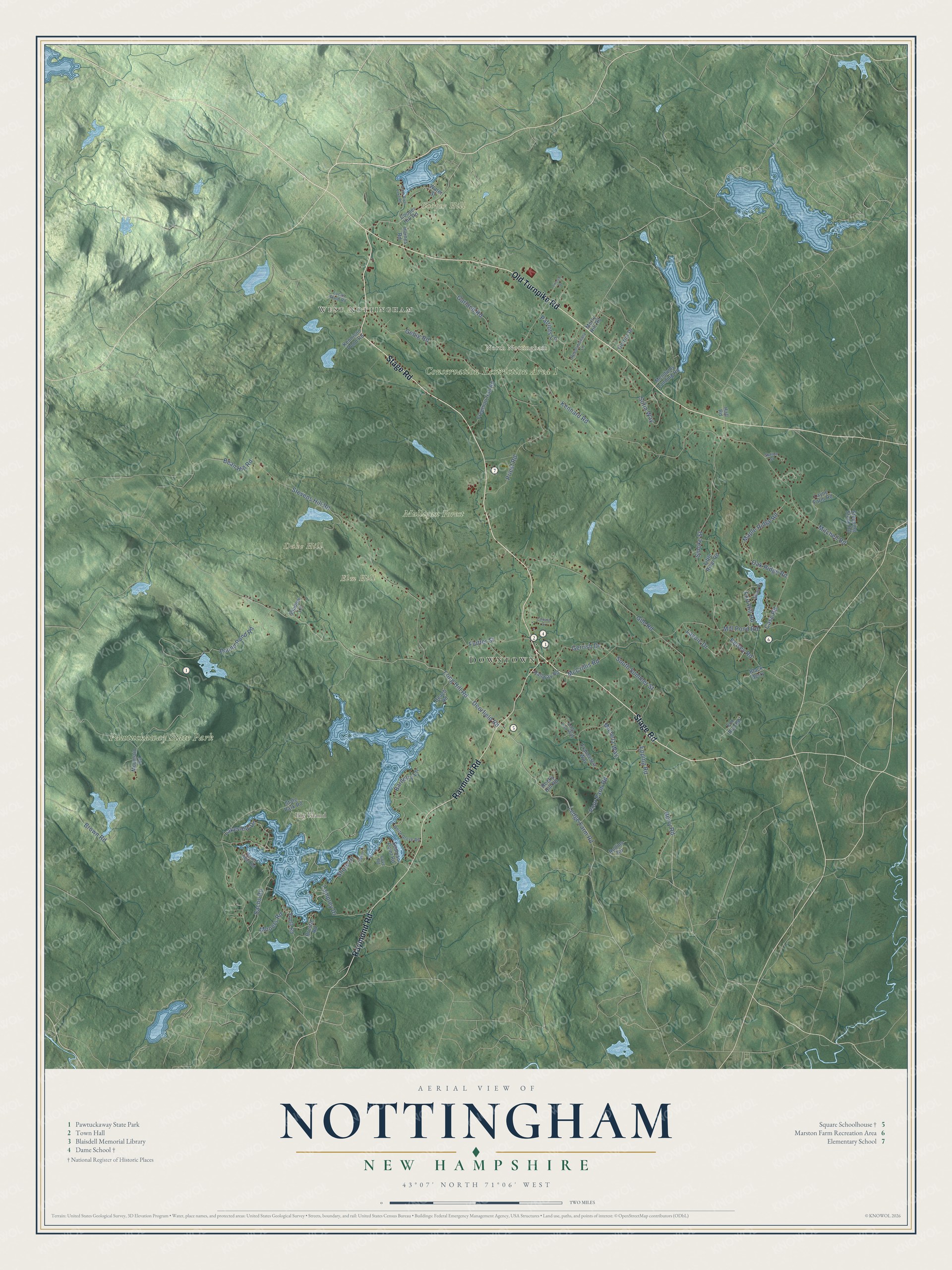
Nottingham, New Hampshire Map Art
Building by building, with labeled streets and shaded relief.
12" x 18" Archival Matte Print
A Map of Home. A Work of Art.
Explore Nottingham, New Hampshire from a whole new perspective. Created using aerial imagery and detailed geographic data, this map captures Nottingham building by building, with labeled streets, familiar landmarks, and shaded topographical relief that highlights the natural contours of the landscape.
Combining modern data with the timeless character of a vintage atlas, this map is just as interesting up close as it is beautiful on the wall. Whether you grew up in Nottingham, spent memorable years there, or call it home today, this unique map is a great way to celebrate a place that means something to you. Zoom in on the preview to look for your street, and then order a print to put your memories on the wall.
Three ways to hang it

Unframed archival matte, a black wood frame or a white wood frame.
Up close
Geography Worth Displaying
This map was created using accurate cartographic data and authoritative geographic sources, including the U.S. Geological Survey (USGS) and FEMA. The map brings together terrain, waterways, roads, and building detail. The majority of the streets are labeled, houses are accurately depicted, and the topography is derived from government sources. Combining local data with carefully composed color and shading leads to this beautifully detailed Nottingham artwork for your wall.
Rather than simply showing street outlines, we’ve included as many of the street names as we could reasonably fit on the map while keeping their names legible. Zoom in on the high resolution preview to see exactly what’s on the map. We truly set out to create a statement piece for anyone who loves Nottingham. So whether it’s for you, or a gift for someone you love, we hope this map of Nottingham brings back fond memories.
Explore the full map of Nottingham, New Hampshire and read about the local places it shows.

Find your street
Names on the Nottingham map
Every name below is printed on this map. Look for your street, your school, the park where you played, or the pond down the road.
Places and landmarks10
- Downtown
- West Nottingham
- North Nottingham
- Big Island
- Cooper Hill
- Duke Hill
- Elm Hill
- Pawtuckaway State Park
- Conservation Restriction Area 1
- Mulligan Forest
Streets and roads77
- Stage Road
- Old Turnpike Road
- Raymond Road
- Deerfield Road
- Ledge Farm Road
- Epping Road
- Barderry Lane
- Stevens Hill Road
- Gile Road
- Kennard Road
- Smoke Street
- Priest Road
- Mitchell Road
- McCrillis Road
- Garland Road
- Gebig Road
- Sofia Way
- Case Road
- Lakeview Drive
- Berry Road
- Round Pond Road
- Poor Farm Road
- Shore Drive
- Flutter Street
- South Summer Street
- Sachs Road
- Long Hill Road
- Maple Ridge Road
- Mill Pond Road
- Gerrish Drive
Show all 77 streets
- Lavoie Drive
- Kelsey Road
- Brown Road
- Mooers Road
- Lamprey Drive
- Oak Ridge Road
- Patriots Lane
- Fort Hill Road
- Bean Hill Road
- Michela Way
- Rollins Road
- Cooper Hill Road
- State Park Road
- Mendums Landing Road
- Mountain Road
- Freeman Hall Road
- Francesca Way
- South Road
- Layne Farm Road
- Little River Road
- Brustle Road
- Beach Road
- Stepping Stone Road
- Kennison Pond Road
- Seaman Point Road
- Merry Hill Road
- Hallway Road
- Gerrior Drive
- Haines Road
- Fox Run Road
- Shadow Lane
- Black Berry
- Water Street
- Rocky Hill Road
- Hall Road
- Lucas Pond Road
- Revolutionary Lane
- White Grove Road
- Bench Head Road
- Swan Drive
- Anna Lisa Way
- Sutton Street
- Cove Road
- Lincoln Drive
- North River Lake Road
- Camelot Court
- Cahill Lane
Names are listed as they appear on the printed map. Zoom into the product photos to find them.
About Nottingham, New Hampshire
Nottingham is a town of 5,229 people in Rockingham County, New Hampshire. In 1722 Lieutenant Governor John Wentworth gave the town its charter and named it after Daniel Finch, 2nd Earl of Nottingham, whom the earlier governors Samuel Shute and Joseph Dudley counted as a friend. One of the first grantees, Peregrine White, came from the family of the Peregrine White born on the Mayflower, the first English child born in New England.
Settlers put the town's streams to work, and at one time 17 watermills were running here. In September 1747 Winnipesaukee Indians killed three settlers, Elizabeth Simpson, Robert Beard and Nathaniel Folsom. The town was once larger, but Deerfield split off as a town of its own in 1766, and Northwood followed in 1773.
- Four Revolutionary War generalsNottingham sent four generals to the Revolutionary War: Thomas Bartlett, Henry Butler, Henry Dearborn and Joseph Cilley. Cilley, born in Nottingham in 1734, had been one of Rogers' Rangers and took part in the December 1774 raid on Fort William and Mary. He fought at Trenton and Princeton, then led the 1st New Hampshire Regiment at Saratoga and Monmouth, with Dearborn as one of his officers. For his bravery, state lawmakers gave him a pair of pistols in 1779.
- The Square SchoolhouseBuilt about 1850, the Square Schoolhouse is named for its spot in Nottingham Square rather than for its shape. It held a classroom on each of its two floors, with a center staircase and cloakrooms, and children studied there until 1920. Today the building belongs to the Daughters of the American Revolution's Else Cilley Chapter, and the Nottingham Historical Society keeps a museum on the upper floor.
- The Dame SchoolBuilt in 1840 as a church on Route 152, the Dame School may hold timbers from a church of 1740, according to local legend. It became a school about 1870 and stopped serving as a meetinghouse about 1878. Schoolmaster Bartholomew Van Dame is said to have given its quill pen weathervane in 1870. Moved toward the town center in 1952 and again later for police parking, it now serves as a local history museum and community center.
- Recycling since 1974Nottingham opened its municipal recycling center in January 1974, and it has run without a break ever since, making it the oldest in the country. Nottingham also became the first town in the nation to require recycling.
- A lake made by millsPawtuckaway Lake began as small ponds. Colonial sawmills raised them in 1729 and 1732, and later the Newmarket Manufacturing Company built a dam to send the water down to its mills in Newmarket. The state took over the 783-acre lake in 1955, and Pawtuckaway State Park now covers about 5,000 acres between its west shore and the ring of the Pawtuckaway Mountains.
Keep exploring New Hampshire
Nottingham is one of 279 New Hampshire towns we've mapped. Every dot on the map is a print of its own.
The search covers every state, New Hampshire first.
Near Nottingham
Order 2 or more town maps and save 10%. Shown in the size and finish you picked above, so they hang as a set.
- Epping 12" x 18" / Archival Matte Print $39.99
- Deerfield 12" x 18" / Archival Matte Print $39.99
- Lee 12" x 18" / Archival Matte Print $39.99


More maps nearby: Northwood, Barrington, Raymond, Fremont and Madbury.
The art of mapping a place
How This Map Was Made
Real places. Remarkable detail. Discover the layers that turn geographic data into a map of home.

The view from above
Aerial imagery reveals the character of the land: woodland, open fields, and the patterns of a place.

The shape of the land
Elevation data brings hills, valleys, and subtle changes in the landscape into view.

The details of home
Roads, waterways, and building footprints come together to make the map feel unmistakably local.

Geography becomes art
Considered color, shading, and typography bring the layers together in a map made for your wall.


Process illustrated with Mendon, Massachusetts. Aerial imagery: USDA NAIP. Terrain: USGS 3D Elevation Program. Map details and finished artwork: KNOWOL.
The Details
About This Print
Choose an archival matte print, or a black or white Ayous wood frame. The archival matte print is unframed.
Select your size and finish above to see the matching product image and price.
Materials & Craftsmanship
A contemporary map with the character of a classic atlas, printed on archival matte paper. Optional frames are made from Ayous wood.
Your printed map does not include the watermark shown in the full-map preview.
Shipping & Delivery
Free shipping within the United States. Every print is made to order in the USA.
Buying a gift? Add a note in your cart and we'll include it. We never put prices in the package.
Prints ship within 2 to 3 business days. Allow 7 to 10 days total from ordering for delivery. Timing may vary during holidays or periods of high order volume.
Read our shipping policy.
Returns and damaged prints
Each print is made to order. Change-of-mind refunds are not available after production.
If your print arrives damaged, misprinted or incorrect, contact support@knowol.com within 30 days of receiving it. Include your order number, photos and a description of the issue.
Read our full refund and replacement policy. For questions about your order, email support@knowol.com.