


Search for another town


Free U.S. delivery 7 to 10 days after you order
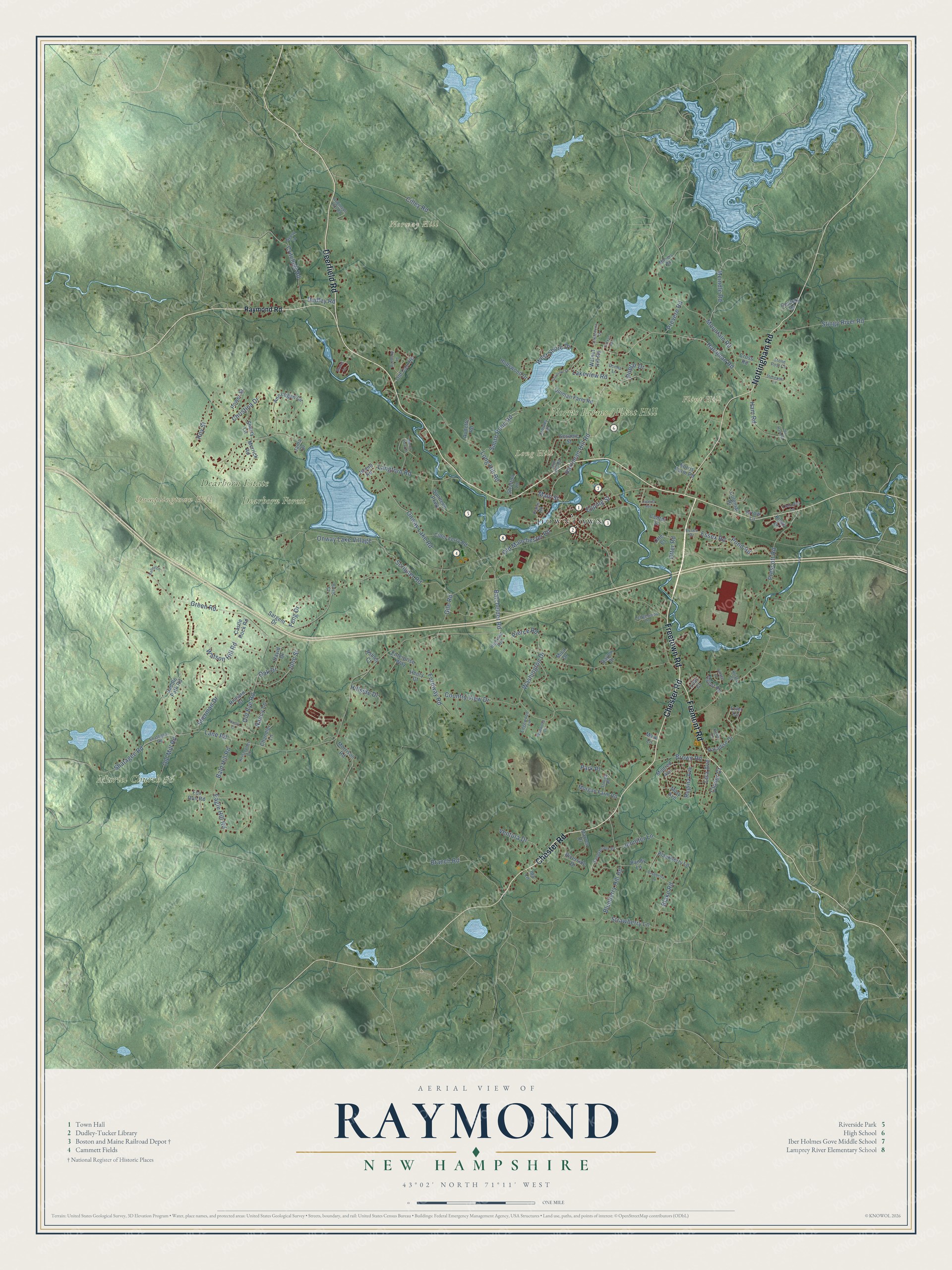
Raymond, New Hampshire Map Art
Building by building, with labeled streets and shaded relief.
12" x 18" Archival Matte Print
A Map of Home. A Work of Art.
Explore Raymond, New Hampshire from a whole new perspective. Created using aerial imagery and detailed geographic data, this map captures Raymond building by building, with labeled streets, familiar landmarks, and shaded topographical relief that highlights the natural contours of the landscape.
Combining modern data with the timeless character of a vintage atlas, this map is just as interesting up close as it is beautiful on the wall. Whether you grew up in Raymond, spent memorable years there, or call it home today, this unique map is a great way to celebrate a place that means something to you. Zoom in on the preview to look for your street, and then order a print to put your memories on the wall.
Three ways to hang it

Unframed archival matte, a black wood frame or a white wood frame.
Up close
Geography Worth Displaying
This map was created using accurate cartographic data and authoritative geographic sources, including the U.S. Geological Survey (USGS) and FEMA. The map brings together terrain, waterways, roads, and building detail. The majority of the streets are labeled, houses are accurately depicted, and the topography is derived from government sources. Combining local data with carefully composed color and shading leads to this beautifully detailed Raymond artwork for your wall.
Rather than simply showing street outlines, we’ve included as many of the street names as we could reasonably fit on the map while keeping their names legible. Zoom in on the high resolution preview to see exactly what’s on the map. We truly set out to create a statement piece for anyone who loves Raymond. So whether it’s for you, or a gift for someone you love, we hope this map of Raymond brings back fond memories.
Explore the full map of Raymond, New Hampshire and read about the local places it shows.

Find your street
Names on the Raymond map
Every name below is printed on this map. Look for your street, your school, the park where you played, or the pond down the road.
Places and landmarks8
- Downtown
- Dumplingtown Hill
- Flint Hill
- Long Hill
- Norway Hill
- Dearborn Estate
- Muriel Church #6
- Dearborn Forest
Streets and roads148
- Freetown Road
- Chester Road
- Fremont Road
- Nottingham Road
- Deerfield Road
- Epping Street
- Eagle Hill Road
- Onway Lake Village
- Branch Road
- Fordway Road
- Essex Road
- Lane Road
- Harriman Hill Road
- Harriman Road
- Green Road
- Langford Road
- Prescott Road
- Batchelder Road
- Main Street
- Old Manchester Road
- Long Hill Road
- Onway Lake Road
- Blueberry Hill Road
- Mountain Road
- Cilley Road
- Washington Drive
- Ham Road
- Watson Hill Road
- Shatagee Road
- Stingy River Road
Show all 148 streets
- Sherman Drive
- Scribner Road
- Critchett Road
- Country View Drive
- West Shore Drive
- John Street
- Blake Road
- Strawberry Lane
- Poplar Drive
- Old Bye Road
- Roy Street
- Christina Drive
- Nancy Lane
- Old Mill Road
- Meindle Road
- Jennifer Lane
- Ventura Drive
- Smith Pond Road
- Pond Road
- Dudley Road
- Lisa Avenue
- Bald Hill Road
- Brown Road
- Park Place
- Hillside Drive
- Pierce Road
- Feng Drive
- Regina Avenue
- Otter Road
- Lakeview Road
- Gile Road
- Prevere Road
- Clover Court
- Oak Drive
- Raymond Road
- Mary Avenue
- Cider Ferry Road
- Ann Logan Circle
- Morrison Road
- Hollywood Drive
- Sesame Street
- Mildred Avenue
- Quinlan Farm Road
- Riverside Drive
- Blackberry Lane
- Merrick Road
- Power Street
- Erler Circle
- Center Street
- Sundeen Parkway
- Morgan Farm Road
- Saddle Path Road
- Enterprise Way
- Old Cart Road
- Lilac Court
- Darren Drive
- Sargent Drive
- Agent Road
- Paradise Drive
- Randy Lane
- Richard Court
- Sherry Lane
- Fox Run Road
- Castle Rock Road
- Walnut Hill Road
- Colonial Drive
- Norris Farm Road
- Cross Road
- Henry Court
- Chandler Lane
- David Drive
- Audette Road
- Arrow Lane
- Stratton Lane
- Century Drive
- Jama Drive
- Ida Lane
- Bayou Drive
- Kings Drive
- Ashley Court
- Mica Drive
- Island Road
- Otter Court
- Mark Lane
- Sandybrook Drive
- Stone Post Circle
- Plains Road
- Robinson Hill Road
- Shattigee Road
- Ledgewood Lane
- Crowley Court
- Essex Drive
- Locksley Lane
- Donna Lane
- Edgewood Lane
- Kristopher Lane
- Birch Court
- Sun Hill Road
- Kristy Court
- Highland Avenue
- Uneda Place
- Gypsy Lane
- Mooers Road
- Katie Lane
- Manor View Drive
- Englewood Drive
- Village Drive
- Raspberry Lane
- Governor Drive
- Stonepost Circle
- Boxwood Lane
- Wildwood Lane
- Kelley Lane
- Old Ham Road
- Parker Avenue
- Nancy Court
- Juanita Avenue
- Bruins Lane
Names are listed as they appear on the printed map. Zoom into the product photos to find them.
About Raymond, New Hampshire
Raymond is a town of 10,684 people in Rockingham County, on the Lamprey River. Families from Exeter settled it as a parish of Chester, and they called it Freetown. Joseph Fullonton's 1875 history says the name came from the ship timber trade: the king claimed the best trees, but local men cut them anyway, and nobody stopped them. Fullonton wrote that Raymond means "the lustrous, luminous or shining world," and the town took that new name when it was incorporated in 1764.
The Concord and Portsmouth Railroad arrived in 1850, and in 1862 the route changed so trains ran to Manchester instead of Concord. Raymond's first station burned in 1878 and was rebuilt. A fire in 1892 wiped out much of the village center and took the second station with it. Passenger trains ended in 1954, the last train came through on July 31, 1980, and crews pulled up the tracks between 1983 and 1985 to make way for a rail trail.
“taking a new and classical one, shows that there are minds not disposed to tread all the time in one path, but capable of thinking and advancing”
- The depot of 1893After the 1892 fire, the Boston and Maine put up a new station at 1 Depot Street in 1893. It is a one-story wooden building whose broad hip roof covers the platforms, and it has changed little since the 19th century. The Raymond Boston and Maine Railroad Depot has been restored and now serves as a museum for the Raymond Historical Society. A locomotive, boxcar, caboose and work car sit on display close by.
- Chain link fence, 1930Frank J. Mafera, a Lane Road resident and member of the town's Select Board, filed in 1930 for a patent on a way to weave chain link fencing, and it was granted in 1931. He ran the Barnyard Fence Company out of his Raymond home, and it later became the New Hampshire Fence Company. In 2022 the state honored him with historical marker number 273.
- A Carnegie libraryAndrew Carnegie gave Raymond $2,000 in 1906 to help build a library. The Dudley-Tucker Library opened two years later, in 1908, facing the Common.
- Onway LakeOnway Lake takes its name from Passaconaway, the 17th-century sachem of the Pennacook people. Campers have used its shore since 1900, first at a YMCA boys' camp run by the county and later at the Boy Scouts' Camp Onway.
Keep exploring New Hampshire
Raymond is one of 279 New Hampshire towns we've mapped. Every dot on the map is a print of its own.
The search covers every state, New Hampshire first.
Near Raymond
Order 2 or more town maps and save 10%. Shown in the size and finish you picked above, so they hang as a set.
- Chester 12" x 18" / Archival Matte Print $39.99
- Fremont 12" x 18" / Archival Matte Print $39.99
- Epping 12" x 18" / Archival Matte Print $39.99


More maps nearby: Sandown, Candia, Nottingham, Deerfield and Brentwood.
The art of mapping a place
How This Map Was Made
Real places. Remarkable detail. Discover the layers that turn geographic data into a map of home.

The view from above
Aerial imagery reveals the character of the land: woodland, open fields, and the patterns of a place.

The shape of the land
Elevation data brings hills, valleys, and subtle changes in the landscape into view.

The details of home
Roads, waterways, and building footprints come together to make the map feel unmistakably local.

Geography becomes art
Considered color, shading, and typography bring the layers together in a map made for your wall.


Process illustrated with Mendon, Massachusetts. Aerial imagery: USDA NAIP. Terrain: USGS 3D Elevation Program. Map details and finished artwork: KNOWOL.
The Details
About This Print
Choose an archival matte print, or a black or white Ayous wood frame. The archival matte print is unframed.
Select your size and finish above to see the matching product image and price.
Materials & Craftsmanship
A contemporary map with the character of a classic atlas, printed on archival matte paper. Optional frames are made from Ayous wood.
Your printed map does not include the watermark shown in the full-map preview.
Shipping & Delivery
Free shipping within the United States. Every print is made to order in the USA.
Buying a gift? Add a note in your cart and we'll include it. We never put prices in the package.
Prints ship within 2 to 3 business days. Allow 7 to 10 days total from ordering for delivery. Timing may vary during holidays or periods of high order volume.
Read our shipping policy.
Returns and damaged prints
Each print is made to order. Change-of-mind refunds are not available after production.
If your print arrives damaged, misprinted or incorrect, contact support@knowol.com within 30 days of receiving it. Include your order number, photos and a description of the issue.
Read our full refund and replacement policy. For questions about your order, email support@knowol.com.