
Search for another town


Free U.S. delivery 7 to 10 days after you order
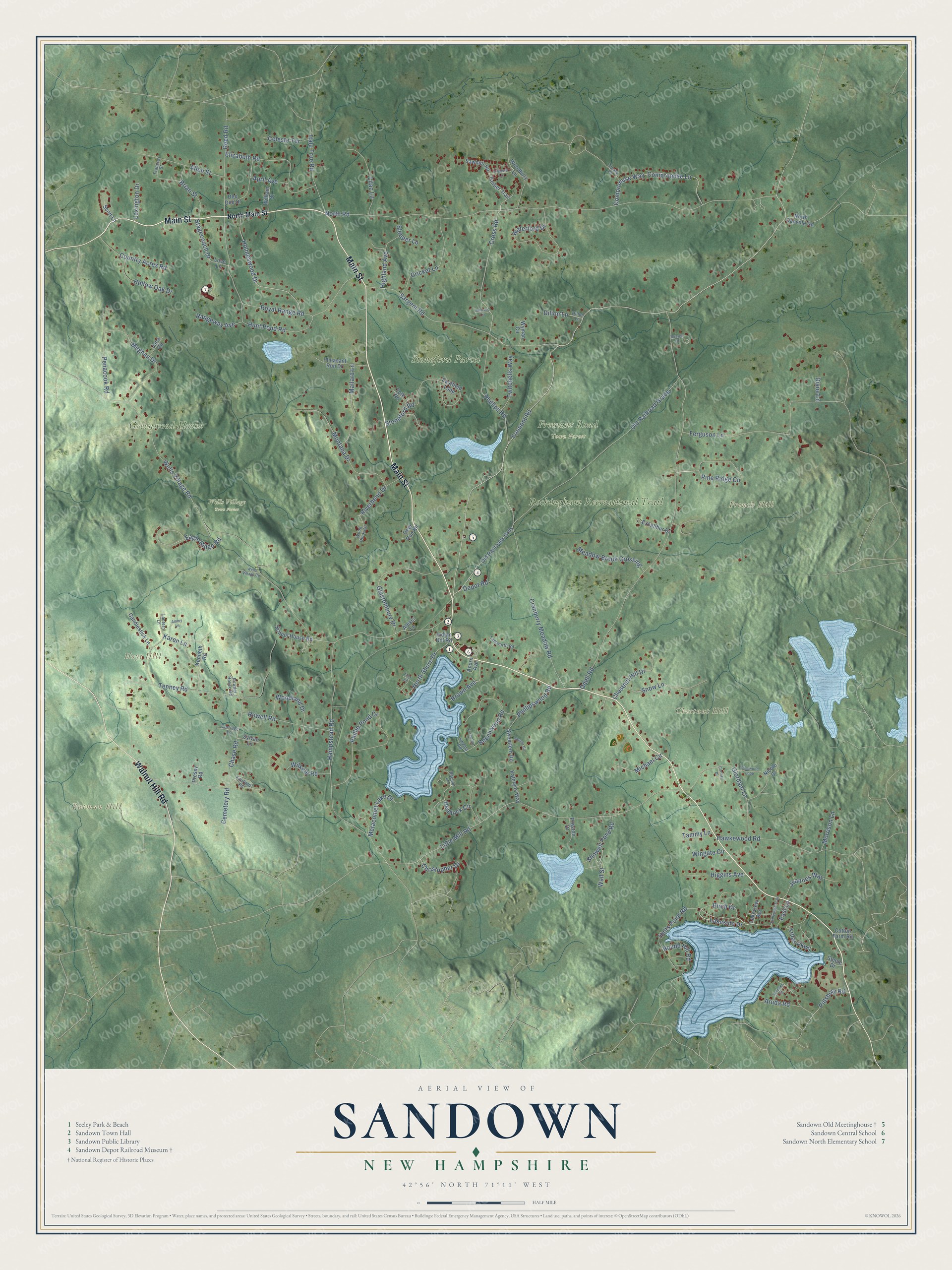
Sandown, New Hampshire Map Art
Building by building, with labeled streets and shaded relief.
12" x 18" Archival Matte Print
A Map of Home. A Work of Art.
Explore Sandown, New Hampshire from a whole new perspective. Created using aerial imagery and detailed geographic data, this map captures Sandown building by building, with labeled streets, familiar landmarks, and shaded topographical relief that highlights the natural contours of the landscape.
Combining modern data with the timeless character of a vintage atlas, this map is just as interesting up close as it is beautiful on the wall. Whether you grew up in Sandown, spent memorable years there, or call it home today, this unique map is a great way to celebrate a place that means something to you. Zoom in on the preview to look for your street, and then order a print to put your memories on the wall.
Three ways to hang it

Unframed archival matte, a black wood frame or a white wood frame.
Up close
Geography Worth Displaying
This map was created using accurate cartographic data and authoritative geographic sources, including the U.S. Geological Survey (USGS) and FEMA. The map brings together terrain, waterways, roads, and building detail. The majority of the streets are labeled, houses are accurately depicted, and the topography is derived from government sources. Combining local data with carefully composed color and shading leads to this beautifully detailed Sandown artwork for your wall.
Rather than simply showing street outlines, we’ve included as many of the street names as we could reasonably fit on the map while keeping their names legible. Zoom in on the high resolution preview to see exactly what’s on the map. We truly set out to create a statement piece for anyone who loves Sandown. So whether it’s for you, or a gift for someone you love, we hope this map of Sandown brings back fond memories.
Explore the full map of Sandown, New Hampshire and read about the local places it shows.

Find your street
Names on the Sandown map
Every name below is printed on this map. Look for your street, your school, the park where you played, or the pond down the road.
Places and landmarks9
- Butman Hill
- Chestnut Hill
- French Hill
- Hoyt Hill
- Stoneford Parcel
- Greenwood-Hooke
- Rockingham Recreational Trail
- Fremont Road Town Forest
- Wells Village Town Forest
Streets and roads140
- Main Street
- Walnut Hill Road
- Fremont Road
- Lakeside Drive
- Old Railroad Grade
- Stagecoach Drive
- Cross Road
- Pillsbury Road
- North Road
- Odell Road
- Hampstead Road
- Wells Village Road
- Little Mill Road
- Cranberry Meadow Road
- Tenney Road
- Royal Range Road
- Sargent Road
- Chase Road
- Phillip Pond Drive
- Pine Ridge Circle
- Waterford Drive
- Montana Drive
- Giordani Lane
- Hawkewood Road
- Holts Point Road
- Compromise Lane
- Compromise Way
- Holmeswood Drive
- Elizabeth Road
- Glastombury Drive
Show all 140 streets
- Phillips Road
- Phillipswood Road
- Meghan Drive
- Eagle Ridge Road
- Ferguson Lane
- Cricket Lane
- Hunt Pond Road
- Trues Parkway
- Rowell Road
- Allen Street
- Reed Road
- Snow Lane
- Mallard Lane
- Hale True Road
- Country Acres Road
- Lilac Lane
- Hemlock Circle
- North Shore Drive
- Meadow Brook Crossing
- Beechwood Road
- Woodland Drive
- Chestnut Hill Drive
- Brian Street
- Hollow Oak Drive
- Jeannes Way
- Twitchells Way
- Lexington Drive
- Metacomet Lake Drive
- Higgins Avenue
- Highland Avenue
- Riverbend Drive
- Showell Pond Road
- Stoneford Road
- Brown Avenue
- Round Hill Road
- Penacook Road
- Michael Circle
- Rangeway Avenue
- Celeste Terrace
- Wilkele Road
- Christopher Drive
- Depot Road
- Birch Drive
- Morrison Lane
- Dilion Lane
- April Avenue
- Cemetery Road
- Sleeper Lane
- Aruda Road
- Wingate Circle
- Tammy Lane
- East Lane
- Diane Lane
- Wall Street
- Karen Lane
- North Main Street
- Timber Trail
- Eastfield Loop
- Kenneth Road
- Scott Lane
- Dee Dee Drive
- School House Road
- Pheasant Run Drive
- Woodbury Lane
- Old Railroads Grds
- Sweetfern Road
- Excalibur Drive
- Candlestick Lane
- North Danville Road
- Kathryns Way
- Lakeview Avenue
- William Street
- Sawmill Road
- Wyman Circle
- Indian Hill Road
- Preston Drive
- Jana Circle
- Deer Run Road
- Tote Road
- Sylvan Lane
- Cotton Farm Road
- Nicole Drive
- Love Lane
- Acorn Avenue
- Steele Drive
- Pressy Road
- Alexis Lane
- Lantern Lane
- Fairfield Road
- Dillon Lane
- Tamworth Road
- Wood Duck Circle
- Powder House Road
- Balsam Lane
- Treaty Court
- Carriage Lane
- Frances Street
- Swamp Road
- Pinewood Loop
- Lemyjoma Trail
- Russell Drive
- Loggers Lane
- Ammy Lane
- Beaver Circle
- Summer Street
- Forest Road
- Wells Village Circle
- Cortney Drive
- First Street
- Johnson Circle
Names are listed as they appear on the printed map. Zoom into the product photos to find them.
About Sandown, New Hampshire
Sandown is a town of 6,548 people in Rockingham County, up from 5,986 in 2010. It began as part of Kingston, and in 1756 Benning Wentworth, the colonial governor, made it a town of its own, named for Sandown on England's Isle of Wight. The Reverend Josiah Cotton, its first minister, built a meetinghouse on Fremont Road in 1774, and the building still stands near the middle of town.
- Built by its first ministerJosiah Cotton's meetinghouse is a nearly square, two-story timber frame. Its pulpit rises 11 feet and still has its sounding board, the first box pews remain, and marble columns hold up the gallery. The clapboards are the originals, fastened with wrought iron nails. Over the 1800s the town added wood stoves and remade part of the gallery for a choir and organ, and changed little else.
- Town meetings until 1929A congregation worshiped in the meetinghouse until 1834, but Sandown went on holding its town meetings there for nearly a century more, until 1929. Since then a local nonprofit has looked after the building, which its caretakers believe has no equal in New Hampshire for how well its inside and outside have survived. It joined the National Register in 1978.
- A depot from 1873The Nashua and Rochester Railroad began building Sandown's station in 1873, just north of the village center off Main Street. Trains kept the single track busy, and with its own post office and telegraph office, a freight depot and a siding that could hold 62 cars, the depot became the heart of town life. Travelers waited in separate rooms for men and women, and a semaphore mast pokes through the roof beside the bay window.
- Rails pulled in 1935Traffic on the line dropped in the early 1930s, and the tracks were taken up in 1935. The state highway department used the depot to store equipment from 1934 to 1977. It then became Sandown's history museum, still on its first site, and it joined the National Register in 1986. The old railbed beside it is now part of the Rockingham Recreational Trail.
Keep exploring New Hampshire
Sandown is one of 279 New Hampshire towns we've mapped. Every dot on the map is a print of its own.
The search covers every state, New Hampshire first.
Near Sandown
Order 2 or more town maps and save 10%. Shown in the size and finish you picked above, so they hang as a set.
- Danville 12" x 18" / Archival Matte Print $39.99
- Hampstead 12" x 18" / Archival Matte Print $39.99
- Chester 12" x 18" / Archival Matte Print $39.99


More maps nearby: Fremont, Kingston, Derry, Atkinson and Raymond.
The art of mapping a place
How This Map Was Made
Real places. Remarkable detail. Discover the layers that turn geographic data into a map of home.

The view from above
Aerial imagery reveals the character of the land: woodland, open fields, and the patterns of a place.

The shape of the land
Elevation data brings hills, valleys, and subtle changes in the landscape into view.

The details of home
Roads, waterways, and building footprints come together to make the map feel unmistakably local.

Geography becomes art
Considered color, shading, and typography bring the layers together in a map made for your wall.


Process illustrated with Mendon, Massachusetts. Aerial imagery: USDA NAIP. Terrain: USGS 3D Elevation Program. Map details and finished artwork: KNOWOL.
The Details
About This Print
Choose an archival matte print, or a black or white Ayous wood frame. The archival matte print is unframed.
Select your size and finish above to see the matching product image and price.
Materials & Craftsmanship
A contemporary map with the character of a classic atlas, printed on archival matte paper. Optional frames are made from Ayous wood.
Your printed map does not include the watermark shown in the full-map preview.
Shipping & Delivery
Free shipping within the United States. Every print is made to order in the USA.
Buying a gift? Add a note in your cart and we'll include it. We never put prices in the package.
Prints ship within 2 to 3 business days. Allow 7 to 10 days total from ordering for delivery. Timing may vary during holidays or periods of high order volume.
Read our shipping policy.
Returns and damaged prints
Each print is made to order. Change-of-mind refunds are not available after production.
If your print arrives damaged, misprinted or incorrect, contact support@knowol.com within 30 days of receiving it. Include your order number, photos and a description of the issue.
Read our full refund and replacement policy. For questions about your order, email support@knowol.com.