


Search for another town


Free U.S. delivery 7 to 10 days after you order
Derry, New Hampshire Map Art
Building by building, with labeled streets and shaded relief.
12" x 18" Archival Matte Print
A Map of Home. A Work of Art.
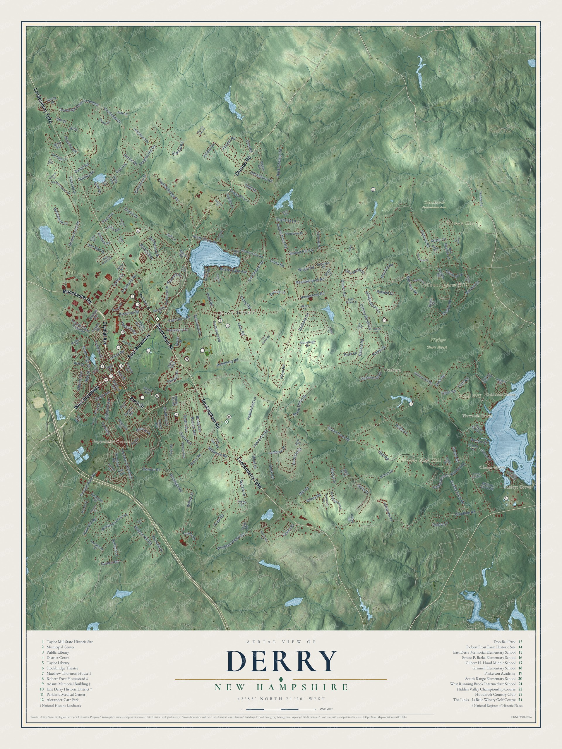
Explore Derry, New Hampshire from a whole new perspective. Created using aerial imagery and detailed geographic data, this map captures Derry building by building, with labeled streets, familiar landmarks, and shaded topographical relief that highlights the natural contours of the landscape.
Combining modern data with the timeless character of a vintage atlas, this map is just as interesting up close as it is beautiful on the wall. Whether you grew up in Derry, spent memorable years there, or call it home today, this unique map is a great way to celebrate a place that means something to you. Zoom in on the preview to look for your street, and then order a print to put your memories on the wall.
Three ways to hang it

Unframed archival matte, a black wood frame or a white wood frame.
Up close
Geography Worth Displaying
This map was created using accurate cartographic data and authoritative geographic sources, including the U.S. Geological Survey (USGS) and FEMA. The map brings together terrain, waterways, roads, and building detail. The majority of the streets are labeled, houses are accurately depicted, and the topography is derived from government sources. Combining local data with carefully composed color and shading leads to this beautifully detailed Derry artwork for your wall.
Rather than simply showing street outlines, we’ve included as many of the street names as we could reasonably fit on the map while keeping their names legible. Zoom in on the high resolution preview to see exactly what’s on the map. We truly set out to create a statement piece for anyone who loves Derry. So whether it’s for you, or a gift for someone you love, we hope this map of Derry brings back fond memories.
Explore the full map of Derry, New Hampshire and read about the local places it shows.

Find your street
Names on the Derry map
Every name below is printed on this map. Look for your street, your school, the park where you played, or the pond down the road.
Places and landmarks13
- East Derry
- Conleys Grove
- Chases Grove
- Collettes Grove
- Howards Grove
- Peppermint Corner
- Bond Hill
- Brandy Rock Hill
- Butman Hill
- Cunningham Hill
- Cole Marsh Conservation Area
- Weber Town Forest
Show all 13 places
- Hubbard
Streets and roads248
- East Broadway
- Manchester Road
- West Broadway
- South Main Street
- Crystal Avenue
- Birch Street
- Londonderry Turnpike
- Rockingham Road
- Chester Road
- Old Auburn Road
- Old Chester Road
- East Derry Road
- North High Street
- Island Pond Road
- Lane Road
- Ash Street
- Hampstead Road
- Fairway Drive
- Windham Road
- Kendall Pond Road
- Lawrence Road
- High Street
- Overledge Drive Extended
- Fordway Extended
- Goodhue Road
- Brandy Rock Road
- North Shore Road
- English Range Road
- Gulf Road
- Walnut Hill Road
Show all 248 streets
- Tsienneto Road
- Scobie Pond Road
- Frost Road
- Drew Road
- Kilrea Road
- Redfield Circle
- Mill Road
- Floyd Road
- Adams Pond Road
- Damren Road
- Stark Road
- Windham Depot Road
- Overledge Drive
- Berry Road
- Bedard Avenue
- Kristin Drive
- Humphrey Road
- Oleson Road
- Cemetery Road
- Back Chester Road
- Scenic Drive
- Pingree Hill Road
- Lampton Drive
- Fordway
- Pond Road
- Gervaise Drive
- Brady Avenue
- Harvest Drive
- Beaver Lake Avenue
- Shelley Road
- Wright Road
- Beacon Hill Road
- Hunter Drive
- Franklin Street
- Pinkerton Street
- Faith Drive
- Emerald Drive
- Ballard Road
- Meadowbrook Road
- Bowers Road
- Paul Avenue
- Juniper Road
- Linlew Drive
- Hope Hill Road
- Hampshire Drive
- South Avenue
- Barkland Drive
- Village Brook Lane
- James Street
- Miltimore Road
- Gaita Drive
- Elwood Road
- Amherst Drive
- Highland Avenue
- Maxwell Drive
- Stone Fence Drive
- Hillside Avenue
- Wentworth Lane
- Claire Avenue
- Colony Brook Lane
- Oxbow Lane
- Dustin Avenue
- Cove Drive
- Kilrea Drive
- Dixon Lane
- Garvin Road
- Birchwood Drive
- Al Street
- Cross Road
- Peabody Road
- Don Mac Drive
- Featherbed Lane
- Bartlett Road
- Taryn Road
- Kingsbury Street
- Alyssa Drive
- Bayberry Lane
- Weston Street
- Morrison Road
- Dattillo Road
- Drake Lane
- Jeff Lane
- Willow Street
- Lenox Road
- Towne Drive
- Schurman Drive
- Gordon Road
- Bradford Street
- Bonnie Lane
- Maurice Road
- Eastman Drive
- Young Road
- Brier Lane
- Skylark Drive
- Brian Avenue
- Steele Road
- Blunt Drive
- Daniel Road
- Viza Avenue
- Settlers Lane
- Lorri Road
- Cole Road
- Bill Street
- Oak Street
- Folsom Road
- Ela Avenue
- Warner Hill Road
- Franklin Street Extended
- Derryfield Road
- Drew Woods Drive
- Whitney Grove Road
- Montgomery Farm Road
- Sheldon Road
- Sunset Avenue
- Bisbee Circle
- Pondview Drive
- Buttonwood Drive
- Indian Hill Road
- Ledgewood Drive
- Hubbard Hill Road
- Hood Kroft Drive
- Partridge Lane
- Nut Meadow Lane
- Gamache Road
- Westgate Road
- Lesley Circle
- Pierce Avenue
- Dexter Street
- Beaver Lake Road
- Dolores Avenue
- Londonderry Lane
- Stoneleigh Drive
- Steven Avenue
- Spinnaker Drive
- Wildwood Avenue
- Jade Court
- Dixons Lane
- Clyde Road
- Coles Grove Road
- Pembroke Drive
- Taylor Brook Lane
- Tyler Road
- Summit Avenue
- Holiday Avenue
- Heritage Lane
- Brook Street
- Heather Lane
- Tinkham Avenue
- Railroad Avenue
- Donovan Drive
- Hilda Avenue
- Twinbrook Drive
- Nesmith Street
- Cella Drive
- Spring Drive
- Tenney Road
- Mary Jo Lane
- Magnolia Lane
- Rocco Drive
- Beaver Road
- Derry Way
- Fox Den Road
- Pearl Street
- Rita Avenue
- Berge Lane
- Keats Drive
- Fenway Street
- Field Road
- Winter Hill Road
- Indian Hill
- Mirra Avenue
- Conleys Grove Road
- Collettes Grove Road
- Old Manchester Road
- Pemigewasset Circle
- Belle Brook Lane
- Quaker Drive
- Norman Drive
- Rollins Street
- Madden Road
- Hood Road
- Orchard Drive
- Sunview Drive
- Cilley Road
- Norton Street
- Damore Lane
- Deer Run
- Olde Coach Road
- Michael Avenue
- Peter Drive
- Rider Lane
- Wryan Road
- Kelly Drive
- Sanborn Road
- Mecca Lane
- Alder Court
- Oxford Road
- Cyril Road
- North Main Street
- Chases Grove Road
- Richardson Drive
- Spollett Drive
- Overlook Drive
- Sagamore Drive
- Dubeau Drive
- Squamscott Avenue
- Raelynn Drive
- Regency Road
- Tracy Drive
- Carberry Drive
- Middleridge Road
- Gena Avenue
- Fox Hollow Road
- Harantis Lake Road
- Transfer Lane
- Jewell Lane
- Topaz Circle
- Circle Way
Names are listed as they appear on the printed map. Zoom into the product photos to find them.
About Derry, New Hampshire
Derry is a New Hampshire community in Rockingham County, where the 2020 census counted 34,317 residents. The town extends across 36.3 square miles.
- 34,317 residentsCounted in the 2020 census.
- Rockingham CountyDerry is one of the New Hampshire communities located in Rockingham County.
- 36.3 square milesThe Census Bureau gives this as Derry's total area.
- Incorporated in 1814The town was incorporated in 1814.
Keep exploring New Hampshire
Derry is one of 279 New Hampshire towns we've mapped. Every dot on the map is a print of its own.
The search covers every state, New Hampshire first.
Near Derry
Order 2 or more town maps and save 10%. Shown in the size and finish you picked above, so they hang as a set.
- Windham 12" x 18" / Archival Matte Print $39.99
- Hampstead 12" x 18" / Archival Matte Print $39.99
- Londonderry 12" x 18" / Archival Matte Print $39.99


More maps nearby: North Salem, Sandown, North Londonderry, Atkinson and Chester.
The art of mapping a place
How This Map Was Made
Real places. Remarkable detail. Discover the layers that turn geographic data into a map of home.

The view from above
Aerial imagery reveals the character of the land: woodland, open fields, and the patterns of a place.

The shape of the land
Elevation data brings hills, valleys, and subtle changes in the landscape into view.

The details of home
Roads, waterways, and building footprints come together to make the map feel unmistakably local.

Geography becomes art
Considered color, shading, and typography bring the layers together in a map made for your wall.


Process illustrated with Mendon, Massachusetts. Aerial imagery: USDA NAIP. Terrain: USGS 3D Elevation Program. Map details and finished artwork: KNOWOL.
The Details
About This Print
Choose an archival matte print, or a black or white Ayous wood frame. The archival matte print is unframed.
Select your size and finish above to see the matching product image and price.
Materials & Craftsmanship
A contemporary map with the character of a classic atlas, printed on archival matte paper. Optional frames are made from Ayous wood.
Your printed map does not include the watermark shown in the full-map preview.
Shipping & Delivery
Free shipping within the United States. Every print is made to order in the USA.
Buying a gift? Add a note in your cart and we'll include it. We never put prices in the package.
Prints ship within 2 to 3 business days. Allow 7 to 10 days total from ordering for delivery. Timing may vary during holidays or periods of high order volume.
Read our shipping policy.
Returns and damaged prints
Each print is made to order. Change-of-mind refunds are not available after production.
If your print arrives damaged, misprinted or incorrect, contact support@knowol.com within 30 days of receiving it. Include your order number, photos and a description of the issue.
Read our full refund and replacement policy. For questions about your order, email support@knowol.com.