


Search for another town


Free U.S. delivery 7 to 10 days after you order
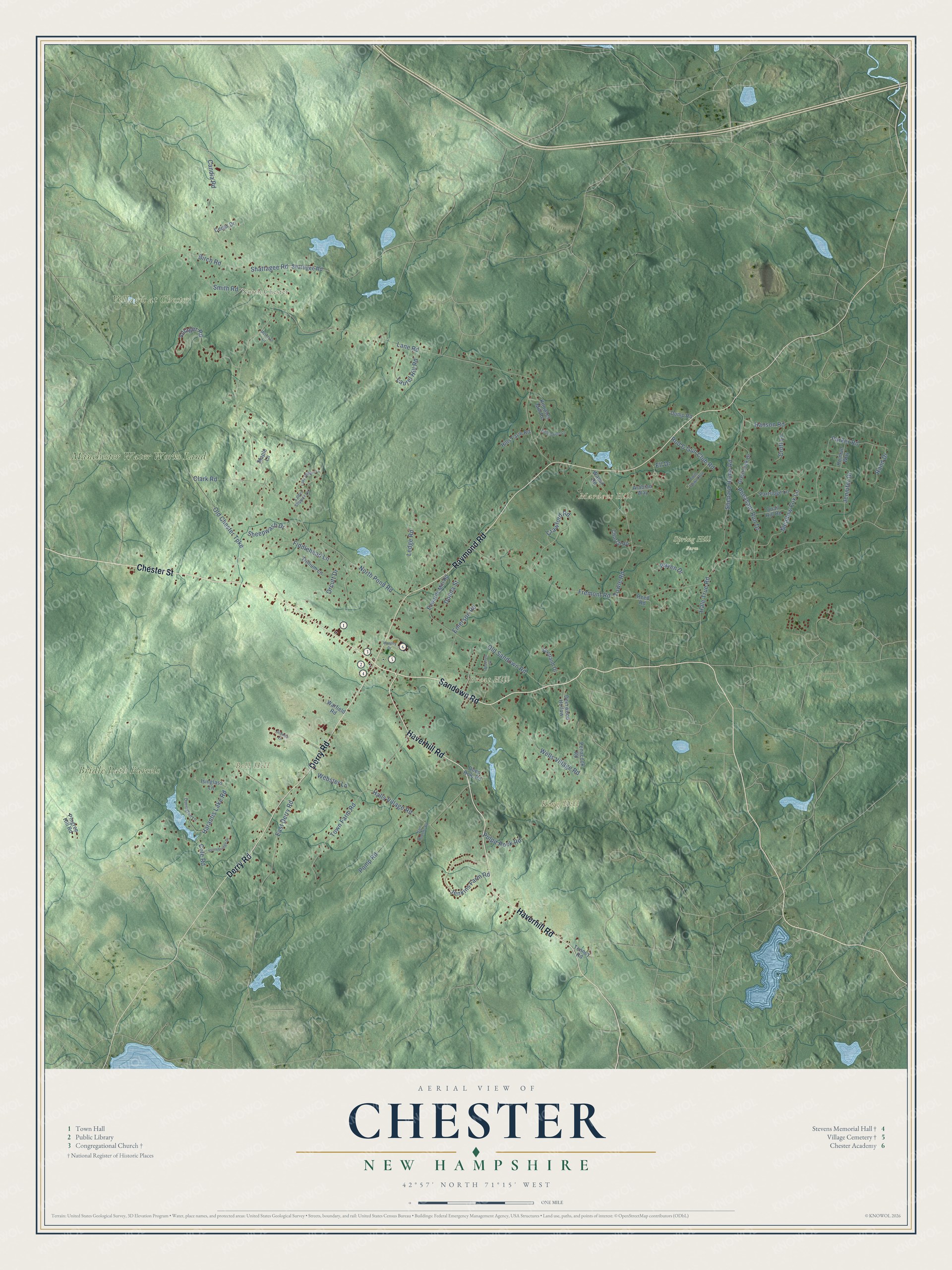
Chester, New Hampshire Map Art
Building by building, with labeled streets and shaded relief.
12" x 18" Archival Matte Print
A Map of Home. A Work of Art.
Explore Chester, New Hampshire from a whole new perspective. Created using aerial imagery and detailed geographic data, this map captures Chester building by building, with labeled streets, familiar landmarks, and shaded topographical relief that highlights the natural contours of the landscape.
Combining modern data with the timeless character of a vintage atlas, this map is just as interesting up close as it is beautiful on the wall. Whether you grew up in Chester, spent memorable years there, or call it home today, this unique map is a great way to celebrate a place that means something to you. Zoom in on the preview to look for your street, and then order a print to put your memories on the wall.
Three ways to hang it

Unframed archival matte, a black wood frame or a white wood frame.
Up close
Geography Worth Displaying
This map was created using accurate cartographic data and authoritative geographic sources, including the U.S. Geological Survey (USGS) and FEMA. The map brings together terrain, waterways, roads, and building detail. The majority of the streets are labeled, houses are accurately depicted, and the topography is derived from government sources. Combining local data with carefully composed color and shading leads to this beautifully detailed Chester artwork for your wall.
Rather than simply showing street outlines, we’ve included as many of the street names as we could reasonably fit on the map while keeping their names legible. Zoom in on the high resolution preview to see exactly what’s on the map. We truly set out to create a statement piece for anyone who loves Chester. So whether it’s for you, or a gift for someone you love, we hope this map of Chester brings back fond memories.
Explore the full map of Chester, New Hampshire and read about the local places it shows.

Find your street
Names on the Chester map
Every name below is printed on this map. Look for your street, your school, the park where you played, or the pond down the road.
Places and landmarks9
- North Chester
- Bell Hill
- Great Hill
- King Hill
- Mardens Hill
- Bridle Path Parcels
- Villages at Chester
- Manchester Water Works Land
- Spring Hill Farm
Streets and roads82
- Chester Street
- Sandown Road
- Derry Road
- Raymond Road
- Haverhill Road
- Shattagee Road
- Birch Road
- Candia Road
- Fremont Road
- Lane Road
- Harantis Lake Road
- Old Chester Turnpike
- Halls Village Road
- North Pond Road
- Shepard Home Road
- Old Sandown Road
- Meadow Fox Lane
- Jennifer Drive
- Towle Road
- Villager Road
- Crawford Road
- Pomp Road
- Wells Village Road
- Jenkins Farm Road
- East Derry Road
- Town Farm Road
- Orcutt Drive
- Smith Road
- Parker Road
- Ledge Road
Show all 82 streets
- Pheasant Run Drive
- Rand Drive
- Fiddlehead Lane
- Laurel Hill Road
- Clark Road
- Webster Lane
- Sheepwash Drive
- Rod & Gun Club Road
- Raven Drive
- Hanson Road
- Pulpit Rock Road
- Hale True Road
- Croft Lane
- Donna Street
- Emerson Road
- Cole Road
- Ell Drive
- Shattigee Road
- Partridge Lane
- Wason Road
- Knowles Mill Road
- Great Oak Drive
- Trillium Lane
- Edwards Mill Road
- Arabian Way
- Isinglass Lane
- Tenney Road
- Quail Hill Road
- Deerwood Hollow
- Hills Farm Road
- Warfield Road
- Penacook Road
- Shetland Drive
- Pingree Hill Road
- Church Road
- Holman Way
- Reed Road
- Deep Hole Road
- Dump Road
- Cedar Drive
- Maple Lane
- Ladys Slipper Lane
- Twin Fawn Run
- Durington Lane
- Lady Slipper Lane
- Stonebridge Drive
- Opossum Drive
- Bittersweet Lane
- Hart Roberts Road
- Murphy Drive
- McIntosh Lane
- Granite Lane
Names are listed as they appear on the printed map. Zoom into the product photos to find them.
About Chester, New Hampshire
Chester is a town of 5,232 people in Rockingham County, between Derry and Raymond. In 1719 a group of about eighty people, most of them from Portsmouth and Hampton, joined together to claim land in what was then known as the Chesnut Country. They posted three men on the tract to guard it while they worked toward a lawful title, and after a long struggle they won a grant ten miles square.
Families from Rye and Hampton moved in at once, led by men such as Samuel Ingalls, Jonathan Goodhue, Jacob Sargent, Ebenezer Dearborn and Robert Smith. On May 8, 1722, the township, known until then as Cheshire, was incorporated as Chester, with more than 120 square miles. Over the next century it shrank: Candia split off in 1763, part of Hooksett went in 1822, and the Long Meadows section became the town of Auburn in 1845.
- A meeting house from 1773The Chester Congregational Church began as a plain colonial meeting house, with its frame raised in 1773. Around 1840 the congregation remade it in the Greek Revival style, copying a church that neighboring Candia had built in 1839. Its three-stage tower holds an E. Howard and Company clock and a bell that George Handel Holbrook of Medway, Massachusetts, cast. Inside, the first roof trusses survive. It joined the National Register in 1986.
- A town hall dedicated in 1910Stevens Memorial Hall is the only building Chester ever put up to serve as its town hall. George G. Adams, an architect from Lawrence, Massachusetts, drew the plans, and construction took three years. Town meetings, plays and other gatherings filled its upstairs auditorium, and the Chester Free Library shared the building from 1930 to 1981. In 2000 the town offices moved into a former school building, and in 2004 the hall was listed on the National Register.
- Where the Exeter River risesThe Exeter River starts in Chester. Its waters and those of Towle Brook flow to the Piscataqua, while water from the town's western side runs toward Massabesic Lake and the Merrimack. The town's highest ground is an unnamed hill lying northwest of Harantis Lake and to the west of Bell Hill, with two knobs that each reach at least 635 feet.
Keep exploring New Hampshire
Chester is one of 279 New Hampshire towns we've mapped. Every dot on the map is a print of its own.
The search covers every state, New Hampshire first.
Near Chester
Order 2 or more town maps and save 10%. Shown in the size and finish you picked above, so they hang as a set.
- Raymond 12" x 18" / Archival Matte Print $39.99
- Sandown 12" x 18" / Archival Matte Print $39.99
- Auburn 12" x 18" / Archival Matte Print $39.99


More maps nearby: Candia, Derry, Fremont, Danville and Hampstead.
The art of mapping a place
How This Map Was Made
Real places. Remarkable detail. Discover the layers that turn geographic data into a map of home.

The view from above
Aerial imagery reveals the character of the land: woodland, open fields, and the patterns of a place.

The shape of the land
Elevation data brings hills, valleys, and subtle changes in the landscape into view.

The details of home
Roads, waterways, and building footprints come together to make the map feel unmistakably local.

Geography becomes art
Considered color, shading, and typography bring the layers together in a map made for your wall.


Process illustrated with Mendon, Massachusetts. Aerial imagery: USDA NAIP. Terrain: USGS 3D Elevation Program. Map details and finished artwork: KNOWOL.
The Details
About This Print
Choose an archival matte print, or a black or white Ayous wood frame. The archival matte print is unframed.
Select your size and finish above to see the matching product image and price.
Materials & Craftsmanship
A contemporary map with the character of a classic atlas, printed on archival matte paper. Optional frames are made from Ayous wood.
Your printed map does not include the watermark shown in the full-map preview.
Shipping & Delivery
Free shipping within the United States. Every print is made to order in the USA.
Buying a gift? Add a note in your cart and we'll include it. We never put prices in the package.
Prints ship within 2 to 3 business days. Allow 7 to 10 days total from ordering for delivery. Timing may vary during holidays or periods of high order volume.
Read our shipping policy.
Returns and damaged prints
Each print is made to order. Change-of-mind refunds are not available after production.
If your print arrives damaged, misprinted or incorrect, contact support@knowol.com within 30 days of receiving it. Include your order number, photos and a description of the issue.
Read our full refund and replacement policy. For questions about your order, email support@knowol.com.