


Search for another town


Free U.S. delivery 7 to 10 days after you order
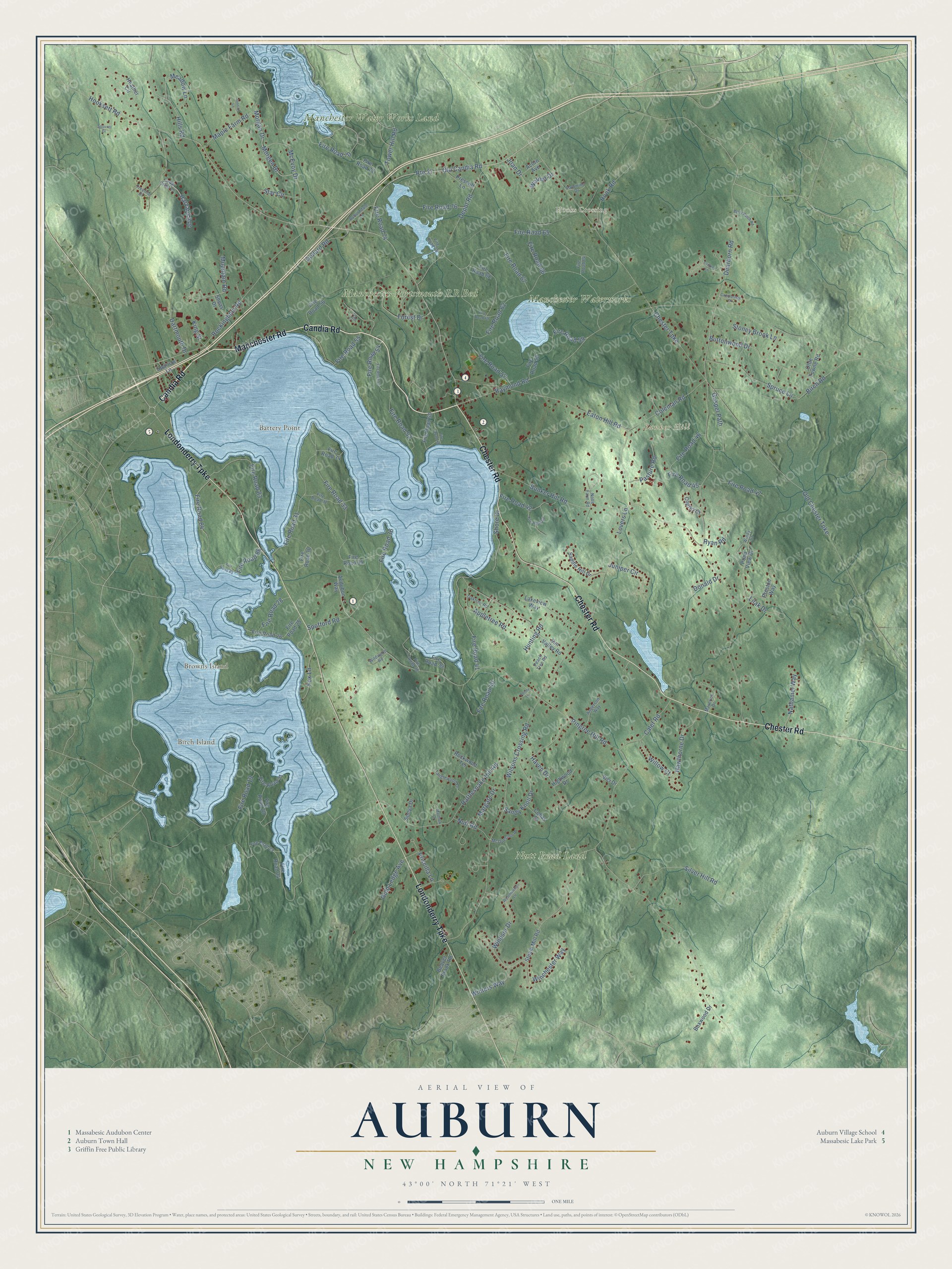
Auburn, New Hampshire Map Art
Building by building, with labeled streets and shaded relief.
12" x 18" Archival Matte Print
A Map of Home. A Work of Art.
Explore Auburn, New Hampshire from a whole new perspective. Created using aerial imagery and detailed geographic data, this map captures Auburn building by building, with labeled streets, familiar landmarks, and shaded topographical relief that highlights the natural contours of the landscape.
Combining modern data with the timeless character of a vintage atlas, this map is just as interesting up close as it is beautiful on the wall. Whether you grew up in Auburn, spent memorable years there, or call it home today, this unique map is a great way to celebrate a place that means something to you. Zoom in on the preview to look for your street, and then order a print to put your memories on the wall.
Three ways to hang it

Unframed archival matte, a black wood frame or a white wood frame.
Up close
Geography Worth Displaying
This map was created using accurate cartographic data and authoritative geographic sources, including the U.S. Geological Survey (USGS) and FEMA. The map brings together terrain, waterways, roads, and building detail. The majority of the streets are labeled, houses are accurately depicted, and the topography is derived from government sources. Combining local data with carefully composed color and shading leads to this beautifully detailed Auburn artwork for your wall.
Rather than simply showing street outlines, we’ve included as many of the street names as we could reasonably fit on the map while keeping their names legible. Zoom in on the high resolution preview to see exactly what’s on the map. We truly set out to create a statement piece for anyone who loves Auburn. So whether it’s for you, or a gift for someone you love, we hope this map of Auburn brings back fond memories.
Explore the full map of Auburn, New Hampshire and read about the local places it shows.

Find your street
Names on the Auburn map
Every name below is printed on this map. Look for your street, your school, the park where you played, or the pond down the road.
Places and landmarks9
- Hooks Crossing
- Battery Point
- Birch Island
- Browns Island
- Bunker Hill
- Manchester Water Works Land
- Nutt Road Land
- Manchester-Portsmouth RR Bed
- Manchester Waterworks
Streets and roads159
- Candia Road
- Manchester Road
- Chester Road
- Londonderry Turnpike
- Hooksett Road
- Old Candia Road
- Route 27
- Appletree Road
- Harvard Avenue
- Morgan Drive
- Rattlesnake Hill Road
- Raymond Road
- Pingree Hill Road
- Bunker Hill Road
- Chester Turnpike
- Wilsons Crossing Road
- Dearborn Road
- Spofford Road
- Rockingham Road
- Fire Road 62
- Fire Road 65
- Eaton Hill Road
- Coleman Road
- Birch Road
- Fire Road 33
- Fire Road 41
- Depot Road
- Fire Road 83
- Fire Road 31
- Buttonwood Drive
Show all 159 streets
- Windsor Drive
- Lovers Lane
- Forest Drive
- Haven Drive
- McEvoy Drive
- Fire Road 36
- Spruce Lane
- Fire Road 84
- Fire Road 55
- Silver Hill Road
- Morgen Drive
- Fire Road 40
- Hawthorne Drive
- Hunting Road
- Fire Road 52
- Calef Road
- Fire Road 59
- Gospel Path
- Mountain Road
- Meadow Lane
- Hills Road
- Fire Road 70
- Sandy Knoll Drive
- Fire Road 19
- Maple Farm Road
- Priscilla Lane
- Fire Road 47
- Nathaniel Way
- Fire Road 67
- Fire Road 42
- Tower Hill Road
- Fire Road 45
- Fire Road 76
- Fire Road 57
- Fire Road 46
- Dollard Road
- Walnut Drive
- Hook Road
- Fox Lane
- Lilak Drive
- Pasture Road
- Juniper Circle
- Fire Road 28
- Willow Court
- Winters Way
- Old Chester Turnpike
- Winchester Way
- Joan Drive
- Shore Drive
- Stoney Brook Lane
- Gold Ledge Avenue
- Dartmouth Drive
- Star Circle
- Nutt Road
- Margate Drive
- Fire Road 66
- Donald Drive
- Fire Road 54
- Fire Road 86
- Fire Road 74
- Ryan Road
- King Street
- Audubon Way
- Pond View Drive
- Heather Circle
- Fire Road 68
- Fire Road 56
- Steam Mill Road
- Fire Road 20
- Fire Road 30
- Sun Valley Road
- Fire Road 35
- Fire Road 72
- Fire Road 26
- Fire Road 50
- Beaver Brook Road
- Fire Road 21
- Rockwood Terrace
- Olde Towne Road
- Prescott Lane
- Saddle Hill Drive
- Boxwood Drive
- Fire Road 34
- Fire Road 39
- Highwood Drive
- Fire Road 58
- Lakeview Way
- Preston Way
- Fire Road 24
- Fire Road 25
- Acorn Avenue
- Cohas Drive
- Sheas Drive
- Copley Court
- Sonya Drive
- Sparrow Lane
- Vici Drive
- Cedar Crest Lane
- Nolls Farm Road
- Fire Road 32
- Oaktree Road
- Tanglewood Drive
- Maverick Drive
- Anderson Way
- McQueston Drive
- Auburndale Lane
- Peach Tree Road
- Fire Road 38
- Fire Road 23
- Treeline Drive
- Fire Road 75
- Wildwood Road
- Palomino Drive
- Fire Road 64
- Windy Court
- Fire Road 53
- Fire Road 43
- Fire Road 48
- Squirrel Drive
- Berry Patch Road
- Cricket Lane
- Fire Road 85
- Westminister Lane
- Fire Road 69
- Jennifer Lane
- Campbridge Drive
- Matthew Drive
- Flag Court
- Penny Lane
Names are listed as they appear on the printed map. Zoom into the product photos to find them.
About Auburn, New Hampshire
Auburn is a town of 5,946 people in Rockingham County, east of Manchester. Native Americans settled here in 1624 and fished at a place they called Massabesic, a name the town's largest lake still carries. English settlers came in 1720 and kept the peace with them until the French and Indian War destroyed the Massabesic settlement, and neighboring Chester then claimed the land.
As part of Chester, the area went by Chester Woods, Chester West Parish and Long Meadow. On June 25, 1845, it broke away as an independent town of 1,200 people. It took the name Auburn from Oliver Goldsmith's 18th-century poem "The Deserted Village," which also named Auburn in Maine, Massachusetts and New York.
- Manchester's drinking waterMassabesic Lake spreads over more than 2,500 acres in western Auburn and eastern Manchester, and Manchester draws its public water from it. For that reason no one may swim in it, but sailors, anglers and kayakers use the half farthest from the intake. Its Abenaki name, Massa'nbesek, refers to a great water or a great pond.
- Sunday races on the lakeEvery Sunday the town's sailing club races from the north shore of Massabesic Lake, and boats must go around the lake three times to finish. Spectators follow along in kayaks and canoes or stand on Battery Point, the northern tip of the Massabesic Peninsula, where the Massabesic Audubon Center sits.
- The Duck RaceEach year the Auburn Historical Association holds a Duck Race on Little Massabesic Brook-Sucker Brook. A truck dumps thousands of yellow rubber ducks off the Hooksett Road bridge, and they drift past the waterfall at the Griffin Mill Dam to a finish line by the Griffin Mill Bridge, with prizes for the owners of the fastest ducks. A pie contest awards clay pie trays to its top three bakers.
- The line through townThe Concord and Portsmouth Railroad crossed Auburn and later became the Boston & Maine's Portsmouth Branch. Auburn once had a small passenger depot, but it had few industries along the tracks, so by the mid-1900s most trains simply passed by without stopping. Freight service ended in the early 1980s. The railroad abandoned the line in 1982, and crews removed the rails from 1983 to 1985.
- Pinkerton by 1,119 to 190For many years Auburn sent its high school students to Manchester, and most of them attended Manchester Memorial High School. That changed in 2011, when voters chose Pinkerton Academy in Derry by a count of 1,119 to 190.
Keep exploring New Hampshire
Auburn is one of 279 New Hampshire towns we've mapped. Every dot on the map is a print of its own.
The search covers every state, New Hampshire first.
Near Auburn
Order 2 or more town maps and save 10%. Shown in the size and finish you picked above, so they hang as a set.
- South Hooksett 12" x 18" / Archival Matte Print $39.99
- Manchester 12" x 18" / Archival Matte Print $39.99
- Candia 12" x 18" / Archival Matte Print $39.99


More maps nearby: Chester, North Londonderry, Hooksett, Pinardville and Londonderry.
The art of mapping a place
How This Map Was Made
Real places. Remarkable detail. Discover the layers that turn geographic data into a map of home.

The view from above
Aerial imagery reveals the character of the land: woodland, open fields, and the patterns of a place.

The shape of the land
Elevation data brings hills, valleys, and subtle changes in the landscape into view.

The details of home
Roads, waterways, and building footprints come together to make the map feel unmistakably local.

Geography becomes art
Considered color, shading, and typography bring the layers together in a map made for your wall.


Process illustrated with Mendon, Massachusetts. Aerial imagery: USDA NAIP. Terrain: USGS 3D Elevation Program. Map details and finished artwork: KNOWOL.
The Details
About This Print
Choose an archival matte print, or a black or white Ayous wood frame. The archival matte print is unframed.
Select your size and finish above to see the matching product image and price.
Materials & Craftsmanship
A contemporary map with the character of a classic atlas, printed on archival matte paper. Optional frames are made from Ayous wood.
Your printed map does not include the watermark shown in the full-map preview.
Shipping & Delivery
Free shipping within the United States. Every print is made to order in the USA.
Buying a gift? Add a note in your cart and we'll include it. We never put prices in the package.
Prints ship within 2 to 3 business days. Allow 7 to 10 days total from ordering for delivery. Timing may vary during holidays or periods of high order volume.
Read our shipping policy.
Returns and damaged prints
Each print is made to order. Change-of-mind refunds are not available after production.
If your print arrives damaged, misprinted or incorrect, contact support@knowol.com within 30 days of receiving it. Include your order number, photos and a description of the issue.
Read our full refund and replacement policy. For questions about your order, email support@knowol.com.