


Search for another town


Free U.S. delivery 7 to 10 days after you order
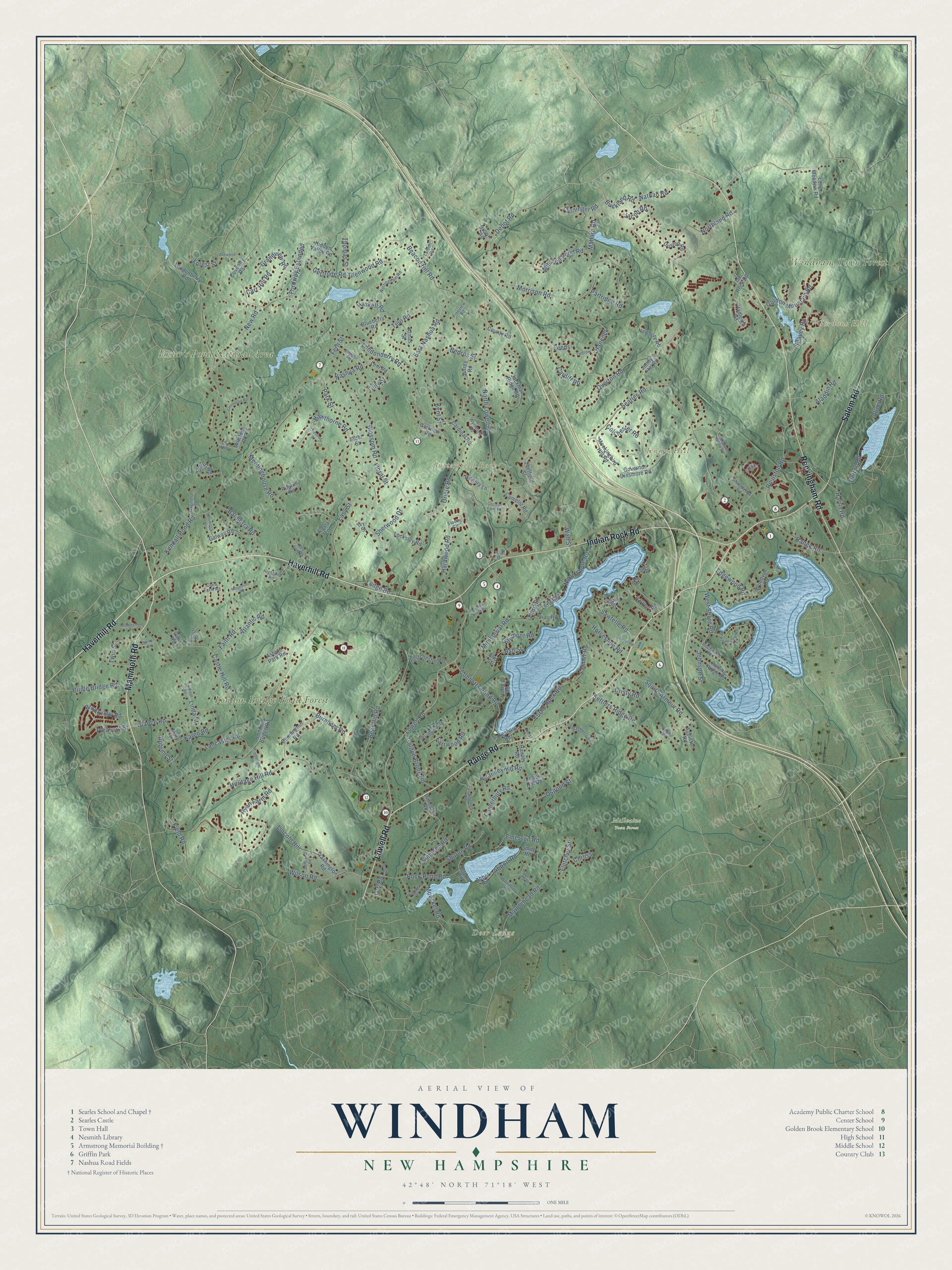
Windham, New Hampshire Map Art
Building by building, with labeled streets and shaded relief.
12" x 18" Archival Matte Print
A Map of Home. A Work of Art.
Explore Windham, New Hampshire from a whole new perspective. Created using aerial imagery and detailed geographic data, this map captures Windham building by building, with labeled streets, familiar landmarks, and shaded topographical relief that highlights the natural contours of the landscape.
Combining modern data with the timeless character of a vintage atlas, this map is just as interesting up close as it is beautiful on the wall. Whether you grew up in Windham, spent memorable years there, or call it home today, this unique map is a great way to celebrate a place that means something to you. Zoom in on the preview to look for your street, and then order a print to put your memories on the wall.
Three ways to hang it

Unframed archival matte, a black wood frame or a white wood frame.
Up close
Geography Worth Displaying
This map was created using accurate cartographic data and authoritative geographic sources, including the U.S. Geological Survey (USGS) and FEMA. The map brings together terrain, waterways, roads, and building detail. The majority of the streets are labeled, houses are accurately depicted, and the topography is derived from government sources. Combining local data with carefully composed color and shading leads to this beautifully detailed Windham artwork for your wall.
Rather than simply showing street outlines, we’ve included as many of the street names as we could reasonably fit on the map while keeping their names legible. Zoom in on the high resolution preview to see exactly what’s on the map. We truly set out to create a statement piece for anyone who loves Windham. So whether it’s for you, or a gift for someone you love, we hope this map of Windham brings back fond memories.
Explore the full map of Windham, New Hampshire and read about the local places it shows.

Find your street
Names on the Windham map
Every name below is printed on this map. Look for your street, your school, the park where you played, or the pond down the road.
Places and landmarks9
- Butterfield Rock
- Deer Ledge
- Gordons Hill
- Jennys Hill
- London Bridge Road Forest
- Foster's Pond Natural Area
- Windham Town Forest
- Griffin Park
- McIlvaine Town Forest
Streets and roads209
- Haverhill Road
- Range Road
- Mammoth Road
- Lowell Road
- Rockingham Road
- Indian Rock Road
- Salem Road
- North Lowell Road
- Morrison Road
- Depot Road
- Kendall Pond Road
- Londonderry Road
- Castle Hill Road
- Searles Road
- Blossom Road
- Marblehead Road
- Nashua Road
- Heritage Hill Road
- Meetinghouse Road
- Ryan Farm Road
- Mitchell Pond Road
- Bear Hill Road
- Northland Road
- West Shore Road
- East Nashua Road
- Horseshoe Road
- Sharon Road
- Roulston Road
- Turtle Rock Road
- Partridge Road
Show all 209 streets
- Cobbetts Pond Road
- Hawthorne Road
- Wilson Road
- Faith Road
- Overton Road
- Glance Road
- Ministerial Road
- Hardwood Road
- Squire Armour Road
- Farrwood Road
- Burnham Road
- Rock Pond Road
- Beacon Hill Road
- Oriole Road
- Grandview Road
- Floral Street
- New Road
- Lincoln Hill
- Telo Road
- Balmorra Road
- Kent Street
- Sawtelle Road
- Gordon Mountain Road
- Harris Road
- Brookview Road
- Bedros Street
- Canterbury Road
- Bramley Hill Road
- Golden Brook Road
- Gertrude Road
- Aladdin Road
- Cardiff Road
- Simpson Road
- Fletcher Street
- Farmer Road
- Park Street
- Doiron Road
- Lancaster Road
- Johnson Street
- Bridle Bridge Road
- North Shore Road
- Settlers Ridge Road
- Wall Street
- Pleasant Street
- Karen Road
- Fordway Extended
- Emerson Road
- Jacob Road
- Hancock
- Gaumont Road
- Tanninger Road
- Ledge Road
- Sherwood Drive
- Abbott Road
- Haskell Road
- Sirod Road
- Tully Street
- Seavey Road
- Carr Hill Road
- Mallard Road
- Nathan Road
- Easy Street
- Field Road
- Moeckel Road
- Colchester Road
- Third Street
- Twin Street
- Osgood Street
- Glenwood Road
- First Street
- Edgewood Road
- Buckland Road
- Atlantic Road
- Cristy Road
- Thomas Street
- Linda Street
- Forest Street
- Autumn Street
- Fern Street
- Corliss
- Allen Road
- Ash Street
- Lori Road
- Leeds
- London Bridge Road
- Harvest Road
- Woodvue Road
- Governor Dinsmore Road
- Jackman Ridge Road
- Mockingbird Hill Road
- Jenny's Hill Road
- Washington Road
- Hadleigh Road
- Sheffield Street
- Camelot Road
- Bennington Road
- Flat Rock Road
- Princeton Road
- Duston Road
- Millstone Road
- Jordan Road
- Coventry Road
- Galway Road
- Rolling Ridge Road
- Hidden Valley Road
- Westchester Road
- Blueberry Road
- Abbot Road
- Locksley Road
- Long Meadow Road
- Londonberry Road
- Hickory Lane
- Surrey Road
- Newbury Road
- Almas Street
- Golfview Road
- Lakeshore Road
- Cardinal Road
- Ashton Park Road
- County Road
- Copps Hill Road
- Smith Road
- Viau Road
- Hawley Road
- Pilgrim Road
- Horne Road
- Appleton Road
- Mary Street
- Leni Road
- Spring Street
- Alder Street
- Brown Road
- Costa Lane
- Gillis Road
- Elm Street
- Ivy Street
- Oak Street
- Nottingham Road
- Stonehedge Road
- Woodland Road
- Ludlow
- Candlewood Road
- Patricia Street
- Woodbury Road
- Clark Farm Road
- Birchwood Road
- Fineview Road
- Highland Road
- Bayberry Road
- Stacey Circle
- Pine Ridge Road
- Tarbell Road
- Juniper Road
- Red Fox Road
- Magnolia Road
- Wynridge Road
- Bancroft Street
- Poplar Road
- Sawyer Road
- Timberlane Road
- Crestwood Road
- Morgan Street
- Deer Run Road
- Old Mill Road
- Sunridge Road
- Oakwood Street
- Shamrock Street
- Cobblestone Road
- Jefferson Road
- McIntosh Hollow Road
- Barker Road
- Ridgemont Road
- Collins Brook Road
- David Road
- Chestnut Street
- Cochran Farm Road
- York Road
- Church Street
- Cheryl Road
Names are listed as they appear on the printed map. Zoom into the product photos to find them.
About Windham, New Hampshire
Windham is a town of 15,817 people in Rockingham County, about 3 miles above the Massachusetts line. The Pawtucket people were its first residents. Scots-Irish families started settling here in 1719, in a district they called Nutfield, which also covered today's Derry and Londonderry.
Some of those settlers wanted a town of their own as early as 1721. They had to wait until 1742 for Governor Benning Wentworth to say yes, and Windham started out as a parish of Londonderry. Some say the name came from Windham in Ireland, the settlers' homeland. Others credit Sir Charles Wyndham, 2nd Earl of Egremont, a friend of the governor. When the first census reached Windham in 1790, it counted 663 people.
- A castle on 1,300 acresEdward Francis Searles came into the world in 1841 in Methuen, Massachusetts. When his wife died in 1891, he turned his fortune to grand buildings, and after 1900 he bought 1,300 acres here. In 1905 he and the architect Henry Vaughan started a quarter-scale version of Stanton Harcourt, a Tudor manor in Oxfordshire. They built it of granite, fieldstone and red sandstone, mostly from his Pelham quarries. It was done in 1915 for about $1,250,000.
- The castle after SearlesSearles died in 1920, and his castle changed hands several times. In 1952 it passed to the Sisters of Mercy, who trained new members of their order there for a time. Castle Junior College taught classes in it from 1962 until the mid-1980s. Work to restore the inside began in 1991, and today people rent it for weddings and other events.
- A school traded for landSearles had his eye on a town lot where a small district schoolhouse stood. He offered Windham another parcel close by and put up a new school and chapel there, starting in 1907 and finishing in 1909. People said it cost him more than $40,000. The Searles School and Chapel was added to the National Register on January 11, 1982.
- A fieldstone library from 1899Colonel Thomas Nesmith, who was born in Windham, paid for the town's first free library, which opened in the town hall in 1874. In 1897 George Washington Armstrong gave money for a real library building. The Windham architect William Weare Dinsmoor designed it, and the mason Loren Emerson Bailey built it of fieldstone. The Armstrong Memorial Building opened in 1899, held the library until 1997, became the town museum and joined the National Register in 2018.
- Governor from Jenny's HillSamuel Dinsmoor was born in Windham in 1766. His grandparents had come to Nutfield in 1723. He went to Congress, helped settle the Massachusetts and New Hampshire boundary in 1825, and became the state's 14th governor in 1831. Voters reelected him twice. His son, Samuel Dinsmoor Jr., later served as the 22nd governor. In July 1909 Searles set a plaque for him near his birthplace on Jenny's Hill.
Keep exploring New Hampshire
Windham is one of 279 New Hampshire towns we've mapped. Every dot on the map is a print of its own.
The search covers every state, New Hampshire first.
Near Windham
Order 2 or more town maps and save 10%. Shown in the size and finish you picked above, so they hang as a set.
- Salem 12" x 18" / Archival Matte Print $39.99
- North Salem 12" x 18" / Archival Matte Print $39.99
- Derry 12" x 18" / Archival Matte Print $39.99


More maps nearby: Pelham, Hudson, Londonderry, Atkinson and Hampstead.
The art of mapping a place
How This Map Was Made
Real places. Remarkable detail. Discover the layers that turn geographic data into a map of home.

The view from above
Aerial imagery reveals the character of the land: woodland, open fields, and the patterns of a place.

The shape of the land
Elevation data brings hills, valleys, and subtle changes in the landscape into view.

The details of home
Roads, waterways, and building footprints come together to make the map feel unmistakably local.

Geography becomes art
Considered color, shading, and typography bring the layers together in a map made for your wall.


Process illustrated with Mendon, Massachusetts. Aerial imagery: USDA NAIP. Terrain: USGS 3D Elevation Program. Map details and finished artwork: KNOWOL.
The Details
About This Print
Choose an archival matte print, or a black or white Ayous wood frame. The archival matte print is unframed.
Select your size and finish above to see the matching product image and price.
Materials & Craftsmanship
A contemporary map with the character of a classic atlas, printed on archival matte paper. Optional frames are made from Ayous wood.
Your printed map does not include the watermark shown in the full-map preview.
Shipping & Delivery
Free shipping within the United States. Every print is made to order in the USA.
Buying a gift? Add a note in your cart and we'll include it. We never put prices in the package.
Prints ship within 2 to 3 business days. Allow 7 to 10 days total from ordering for delivery. Timing may vary during holidays or periods of high order volume.
Read our shipping policy.
Returns and damaged prints
Each print is made to order. Change-of-mind refunds are not available after production.
If your print arrives damaged, misprinted or incorrect, contact support@knowol.com within 30 days of receiving it. Include your order number, photos and a description of the issue.
Read our full refund and replacement policy. For questions about your order, email support@knowol.com.