
Search for another town


Free U.S. delivery 7 to 10 days after you order
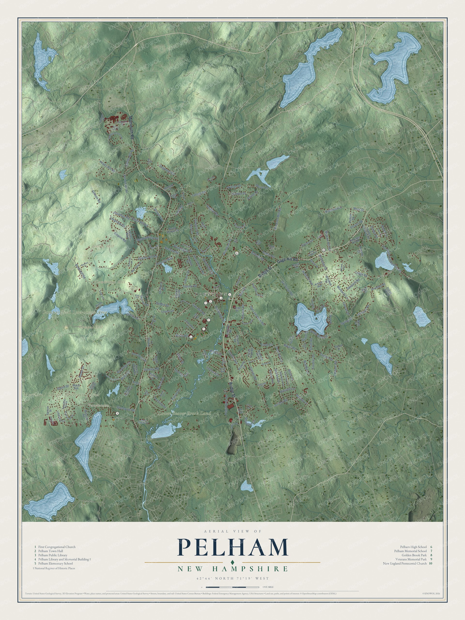
Pelham, New Hampshire Map Art
Building by building, with labeled streets and shaded relief.
12" x 18" Archival Matte Print
A Map of Home. A Work of Art.
Explore Pelham, New Hampshire from a whole new perspective. Created using aerial imagery and detailed geographic data, this map captures Pelham building by building, with labeled streets, familiar landmarks, and shaded topographical relief that highlights the natural contours of the landscape.
Combining modern data with the timeless character of a vintage atlas, this map is just as interesting up close as it is beautiful on the wall. Whether you grew up in Pelham, spent memorable years there, or call it home today, this unique map is a great way to celebrate a place that means something to you. Zoom in on the preview to look for your street, and then order a print to put your memories on the wall.
Three ways to hang it

Unframed archival matte, a black wood frame or a white wood frame.
Up close
Geography Worth Displaying
This map was created using accurate cartographic data and authoritative geographic sources, including the U.S. Geological Survey (USGS) and FEMA. The map brings together terrain, waterways, roads, and building detail. The majority of the streets are labeled, houses are accurately depicted, and the topography is derived from government sources. Combining local data with carefully composed color and shading leads to this beautifully detailed Pelham artwork for your wall.
Rather than simply showing street outlines, we’ve included as many of the street names as we could reasonably fit on the map while keeping their names legible. Zoom in on the high resolution preview to see exactly what’s on the map. We truly set out to create a statement piece for anyone who loves Pelham. So whether it’s for you, or a gift for someone you love, we hope this map of Pelham brings back fond memories.
Explore the full map of Pelham, New Hampshire and read about the local places it shows.

Find your street
Names on the Pelham map
Every name below is printed on this map. Look for your street, your school, the park where you played, or the pond down the road.
Places and landmarks8
- Downtown
- Varnumtown
- Cambridge Hill
- Gage Hill
- Gumpas Hill
- Jeremy Hill
- Gumpas Pond Reservation Area
- Lower Beaver Brook Land
Streets and roads193
- Bridge Street
- Gage Hill Road
- Mammoth Road
- Windham Road
- Atwood Road
- West Street
- Main Street
- Longview Circle
- Old Gage Hill Road North
- Keyes Hill Road
- Jeremy Hill Road
- Marsh Road
- Dutton Road
- Bush Hill Road
- Tallant Road
- Sherburne Road
- Jericho Road
- Nashua Road
- Ledge Road
- Simpson Road
- Currier Road
- Simpson Mill Road
- Hobbs Road
- Webster Avenue
- Misty Lane
- Arlene Drive
- Mulberry Lane
- Garland Drive
- Patriot Drive
- Tenney Road
Show all 193 streets
- Balcom Road
- Hillcrest Lane
- Valley Hill Road
- Burns Road
- Spring Street
- Willow Street
- Brookview Drive
- Shepard Road
- Girl Scout Road
- Koper Lane
- Castle Hill Road
- Lane Road
- Leonard Drive
- Pulpit Rock Road
- Hayden Road
- Clark Circle
- Debbie Drive
- Birch Lane
- Aspen Drive
- Wharf Road
- Brandy Lane
- Saw Mill Road
- Shannon Circle
- Frontier Drive
- Gordon Drive
- Old Bridge Street
- Robinson Lane
- Old Lawrence Road
- South Shore Drive
- Hearthstone Road
- Melody Lane
- Thomas Avenue
- Luann Lane
- Surrey Lane
- Benoit Avenue
- Empire Road
- Lannan Drive
- Wellesley Drive
- Slavin Drive
- Deer Hill Circle
- Washington Street
- Greeley Road
- Meadowview Road
- Dogwood Circle
- Jonathan Road
- Beacon Hill Road
- Loretta Avenue
- Priscilla Way
- Smith Road
- Leblanc Road
- Plower Road
- Lox Lane
- William Drive
- Gibson Road
- Granite Drive
- Dodge Road
- Albert Street
- Grace Road
- May Lane
- Livingston Road
- Wyndridge Circle
- Pelham Road
- Old Gage Hill Road
- McGrath Road
- Mount Vernon Drive
- Hinds Lane
- Baldwin Hill Road
- Drummer Road
- Grouse Run
- Stevens Road
- Sky View Drive
- Litchfield Circle
- Kennedy Drive
- Wilshire Lane
- Stonepost Road
- Poplar Hill Road
- Township Road
- Old County Road
- Youngs Crossing Road
- Lucy Avenue
- Heather Lee Lane
- Woekel Circle
- Vassar Drive
- Bear Hill Road
- David Drive
- Island Pond Road
- Colonial Drive
- Economou Lane
- Hickory Hill Road
- Moekel Road
- Wheaton Drive
- Diamond Hill Drive
- Heritage Road
- Collins Way
- Peabody Lane
- Yarde Drive
- Jennifer Lane
- Goldfinch Drive
- Tina Avenue
- Katie Lane
- Mercury Lane
- Marie Avenue
- Kosik Terrace
- Wood Road
- Kinnal Avenue
- Falcon Drive
- Piper Lane
- Spruce Street
- Brett Circle
- Fox Avenue
- Lisa Terrace
- Lawrence Corner Road
- Westfall Road North
- Spaulding Hill Road
- West Shore Drive
- Scenic View Drive
- Blackstone Circle
- Appaloosa Avenue
- Crescent Circle
- Woodlawn Circle
- Springdale Lane
- Holstein Drive
- Fletcher Way
- Russell Drive
- Westfall Road South
- Moon Shadow Drive
- Coburn Road
- Industrial Drive
- Pondview Road
- Honey Lane
- Pine Ridge Drive
- Sullivan Road
- Susan Drive
- Sandy Circle
- Velma Lane
- Bedard Avenue
- Garland Lane
- Bowley Drive
- Belvina Circle
- Angus Way
- Kens Way
- Carol Street
- Field Drive
- Lori Lane
- Greenmeadow Drive
- Clydesdale Avenue
- Pinewood Drive
- Sagewood Drive
- Lincoln Street
- Harmony Lane
- Grandview Road
- Bowman Lane
- Herrick Circle
- Glenside Drive
- Coburn Avenue
- Dick Tracy Drive
- Armand Road
- Andrea Lane
- Cara Lane
- Blue Jay
- Dale Avenue
- Mossey Lane
- Juniper Lane
Names are listed as they appear on the printed map. Zoom into the product photos to find them.
About Pelham, New Hampshire
Pelham is a town of 14,222 people in Hillsborough County, on the Massachusetts line. Its land first fell within Old Dunstable, under Massachusetts, until the two colonies settled the border between them in 1741 and Pelham landed in New Hampshire. The town was incorporated in 1746 and honored Thomas Pelham-Holles, the Duke of Newcastle, with its name. The first census figures, from 1767, counted 543 residents.
That border also made Pelham the southernmost town in New Hampshire, holding the state's southernmost point. The spot is called the Old Boundary Pine, after a pine tree that marked a disagreement over how the northern edge of Massachusetts was defined. It lies 3 miles north of Lowell's Pawtucket Falls, at the place where the straight border running from the west meets the 3-mile buffer traced along the Merrimack River.
- A library since 1797Pelham founded its public library in 1797, and for about a century the books had no fixed home. In the mid-1890s the town paid for a brick building on a cut granite foundation at 6 Main Street, partly to celebrate 150 years since incorporation and partly to honor its military members. Frederick W. Stickney designed it. It served as the only library building until 2003, now houses the Pelham Historical Society, and joined the National Register in 2011.
- The Ice King of LowellDaniel Gage, a Pelham native born in 1828, lived on the family farm on Gage Hill, named for the family, until he was 25. He harvested ice from lakes and ponds around Greater Lowell, and since he owned the land around those waters, he was Pelham's biggest taxpayer by the late 1880s. When refrigeration ended the ice trade, the family sold or gave away land, including 26 acres that became Gage Field, a children's park in Lowell.
- From Pelham High to spaceRichard M. Linnehan finished Pelham High School in 1975. He worked as an Army veterinarian treating the Navy's marine mammals in San Diego before NASA chose him as an astronaut. His four missions ran from a Spacelab flight in 1996 through the 2002 Hubble servicing mission to a space station assembly flight in 2008, adding up to more than 59 days in orbit and six spacewalks.
Keep exploring New Hampshire
Pelham is one of 279 New Hampshire towns we've mapped. Every dot on the map is a print of its own.
The search covers every state, New Hampshire first.
Near Pelham
Order 2 or more town maps and save 10%. Shown in the size and finish you picked above, so they hang as a set.
- Hudson 12" x 18" / Archival Matte Print $39.99
- Windham 12" x 18" / Archival Matte Print $39.99
- Salem 12" x 18" / Archival Matte Print $39.99


More maps nearby: Nashua, North Salem, Litchfield, Londonderry and Derry.
The art of mapping a place
How This Map Was Made
Real places. Remarkable detail. Discover the layers that turn geographic data into a map of home.

The view from above
Aerial imagery reveals the character of the land: woodland, open fields, and the patterns of a place.

The shape of the land
Elevation data brings hills, valleys, and subtle changes in the landscape into view.

The details of home
Roads, waterways, and building footprints come together to make the map feel unmistakably local.

Geography becomes art
Considered color, shading, and typography bring the layers together in a map made for your wall.


Process illustrated with Mendon, Massachusetts. Aerial imagery: USDA NAIP. Terrain: USGS 3D Elevation Program. Map details and finished artwork: KNOWOL.
The Details
About This Print
Choose an archival matte print, or a black or white Ayous wood frame. The archival matte print is unframed.
Select your size and finish above to see the matching product image and price.
Materials & Craftsmanship
A contemporary map with the character of a classic atlas, printed on archival matte paper. Optional frames are made from Ayous wood.
Your printed map does not include the watermark shown in the full-map preview.
Shipping & Delivery
Free shipping within the United States. Every print is made to order in the USA.
Buying a gift? Add a note in your cart and we'll include it. We never put prices in the package.
Prints ship within 2 to 3 business days. Allow 7 to 10 days total from ordering for delivery. Timing may vary during holidays or periods of high order volume.
Read our shipping policy.
Returns and damaged prints
Each print is made to order. Change-of-mind refunds are not available after production.
If your print arrives damaged, misprinted or incorrect, contact support@knowol.com within 30 days of receiving it. Include your order number, photos and a description of the issue.
Read our full refund and replacement policy. For questions about your order, email support@knowol.com.