


Search for another town


Free U.S. delivery 7 to 10 days after you order
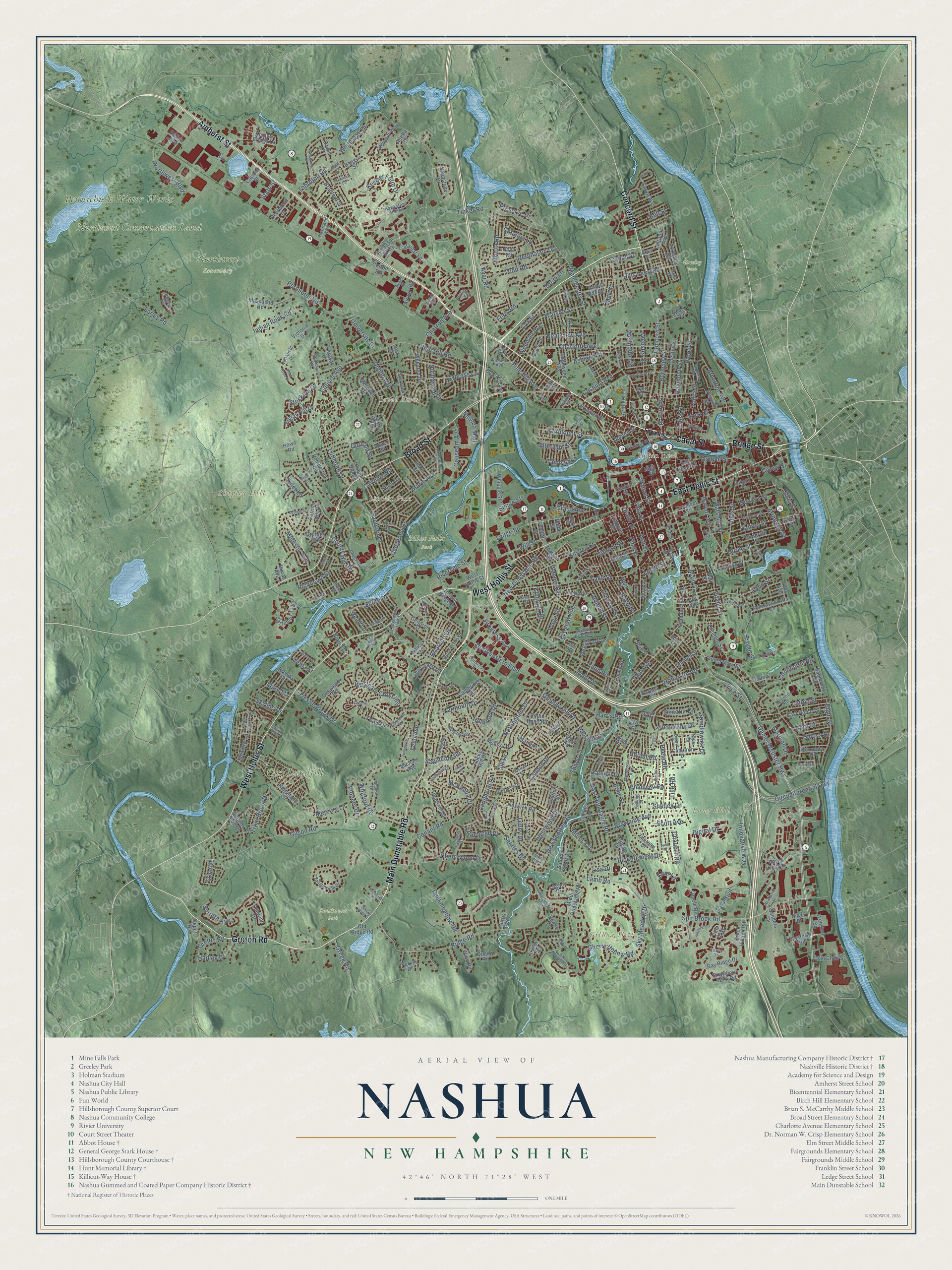
Nashua, New Hampshire Map Art
Building by building, with labeled streets and shaded relief.
12" x 18" Archival Matte Print
A Map of Home. A Work of Art.
Explore Nashua, New Hampshire from a whole new perspective. Created using aerial imagery and detailed geographic data, this map captures Nashua building by building, with labeled streets, familiar landmarks, and shaded topographical relief that highlights the natural contours of the landscape.
Combining modern data with the timeless character of a vintage atlas, this map is just as interesting up close as it is beautiful on the wall. Whether you grew up in Nashua, spent memorable years there, or call it home today, this unique map is a great way to celebrate a place that means something to you. Zoom in on the preview to look for your street, and then order a print to put your memories on the wall.
Three ways to hang it

Unframed archival matte, a black wood frame or a white wood frame.
Up close
Geography Worth Displaying
This map was created using accurate cartographic data and authoritative geographic sources, including the U.S. Geological Survey (USGS) and FEMA. The map brings together terrain, waterways, roads, and building detail. The majority of the streets are labeled, houses are accurately depicted, and the topography is derived from government sources. Combining local data with carefully composed color and shading leads to this beautifully detailed Nashua artwork for your wall.
Rather than simply showing street outlines, we’ve included as many of the street names as we could reasonably fit on the map while keeping their names legible. Zoom in on the high resolution preview to see exactly what’s on the map. We truly set out to create a statement piece for anyone who loves Nashua. So whether it’s for you, or a gift for someone you love, we hope this map of Nashua brings back fond memories.
Explore the full map of Nashua, New Hampshire and read about the local places it shows.

Find your street
Names on the Nashua map
Every name below is printed on this map. Look for your street, your school, the park where you played, or the pond down the road.
Places and landmarks14
- Broad Acres
- Lincoln Park
- Gilboa Hill
- Indian Head
- Long Hill
- Shipley Hill
- Pennichuck Water Works
- City Landfill
- Northwest Conservation Land
- Greeley Park
- Mine Falls Park
- Northwest Sanctuary
Show all 14 places
- Roby Park
- Southwest Park
Streets and roads420
- Amherst Street
- Bridge Street
- Canal Street
- Groton Road
- Main Dunstable Road
- Concord Street
- West Hollis Street
- Broad Street
- East Hollis Street
- Daniel Webster Highway
- Main Street
- Gregg Road
- Kessler Farm Drive
- Circumferential Highway
- Sky Meadow Drive
- Robinson Road
- Spit Brook Road
- Northwest Boulevard
- Searles Road
- County Hill Road
- Whitford Road
- Lamb Road
- Granite Street
- East Dunstable Road
- Tinker Road
- Manchester Street
- Ridge Road
- Conant Road
- Pine Hill Road
- Gilson Road
Show all 420 streets
- Lake Street
- Cherrywood Drive
- Harris Road
- Kinsley Street
- Lund Road
- Coburn Avenue
- Pine Street
- Innovative Way
- Northeastern Boulevard
- Westgate Crossing
- Ledge Street
- Perimeter Road
- Indian Rock Road
- Hills Ferry Road
- Langholm Drive
- Allds Street
- Spindlewick Drive
- Dublin Avenue
- Nottingham Drive
- Taylor Street
- Simon Street
- Almont Street
- Buckmeadow Road
- Westwood Drive
- Tenby Drive
- Bowers Street
- Temple Street
- Lock Street
- Cherry Hollow Road
- New Searles Road
- Ferry Road
- Ash Street
- Timberline Drive
- Trestle Brook Drive
- Fairmount Street
- Watson Street
- Peele Road
- Thornton Road
- Fairview Avenue
- Cox Street
- Coliseum Avenue
- Gillis Street
- Shelley Drive
- Browning Avenue
- Marie Avenue
- Berkeley Street
- Riverside Street
- McKenna Drive
- Arlington Street
- Haines Street
- New Dunstable Road
- Beauview Avenue
- Digital Drive
- Catalina Lane
- Harbor Avenue
- Cheyenne Drive
- Shady Lane
- Marshall Street
- Northwood Drive
- Burke Street
- Fifield Street
- Linwood Street
- Lutheran Drive
- Majestic Avenue
- Vine Street
- Raleigh Drive
- Pioneer Drive
- Pine Hill Avenue
- Tolles Street
- Walnut Street
- Scott Avenue
- Monica Drive
- Farmington Road
- Nashua Mall
- Crown Street
- Palm Street
- Deerhaven Drive
- Webster Street
- Cypress Lane
- Wood Street
- Charlotte Avenue
- Sanborn Drive
- Yarmouth Drive
- Raymond Street
- Tara Boulevard
- Atherton Avenue
- Kent Lane
- White Oak Drive
- Trout Brook Drive
- Elgin Street
- Gilman Street
- Todd Road
- Alder Drive
- Durham Street
- Bicentennial Drive
- Monza Road
- Teak Drive
- Will Street
- Cushing Avenue
- Richmond Street
- Ayer Road
- Holbrook Drive
- Greenwood Drive
- University Drive
- Cannon Drive
- Palisade Drive
- Charron Avenue
- Lille Road
- Progress Avenue
- Hadley Drive
- Kingston Drive
- Tampa Street
- Paul Avenue
- Cross Street
- Preserve Drive
- Ashland Street
- Intervale Street
- Shore Drive
- Nagle Street
- Cider Lane
- Shadwell Road
- Farley Road
- Wellman Avenue
- Serotta Avenue
- Edinburgh Drive
- Decatur Drive
- Briarcliff Drive
- Bolic Street
- April Drive
- Carmine Road
- Chaucer Road
- Wellington Street
- Sagamore Road
- Sugar Hill Drive
- Stockton Drive
- Bell Street
- Forge Drive
- Lynn Street
- Bryant Road
- Skyline Drive
- Grand Avenue
- Linton Street
- Lovell Street
- Bulova Drive
- Marmon Drive
- Mercury Lane
- Wason Avenue
- Drury Lane
- Cabot Drive
- Heidi Lane
- Milk Street
- Lisa Drive
- Mark Street
- Echo Avenue
- Pike Street
- Eric Avenue
- State Street
- Xenia Street
- Jill Drive
- Somerset Parkway
- Villa Way
- Central Street
- South Main Street
- Prescott Street
- Middle Dunstable Road
- Bartemus Trail
- Royal Crest Drive
- Bay Ridge Drive
- Trafalgar Square
- Parrish Hill Drive
- Sanders Drive
- Norma Drive
- King Street
- Gendron Street
- Robin Hood Road
- Elm Street
- Glencliff Way
- Brook Village Road
- Pemberton Road
- Artillery Lane
- Knights Bridge Drive
- Ridgefield Drive
- Wheaton Drive
- Legacy Drive
- Chester Street
- Vieckis Drive
- Cambridge Road
- Norwich Road
- Celina Avenue
- Clement Street
- Forest Park Drive
- Melissa Drive
- Lawndale Avenue
- East Hobart Street
- Schwinn Drive
- Thoreau Drive
- Swart Terrace
- Underhill Street
- Country Side Drive
- Parnell Place
- Syracuse Road
- Hollow Ridge Drive
- Roy Street
- Capitol Street
- Massasoit Road
- East Pearl Street
- Lojko Drive
- Meredith Drive
- Hunt Street
- Marian Lane
- Edgewood Avenue
- Bradford Street
- Massachusetts Drive
- Salmon Brook Drive
- Winn Road
- Danforth Road
- Webster Square
- Adella Drive
- Chapel Hill Drive
- Spalding Street
- Whipple Street
- Strawberry Bank Road
- Old Coach Road
- Deerwood Drive
- Hyacinth Drive
- Prospect Street
- Parker Drive
- Oracle Drive
- Blue Hill Avenue
- Cameron Drive
- Dan Chan Street
- Quarry Road
- Michael Avenue
- Shelton Street
- Eastbrook Drive
- Cotton Road
- Old Ridge Road
- Lewis Street
- Brittany Way
- Luke Street
- Learned Street
- Meadow Lane
- Silver Drive
- Sandstone Drive
- Auburn Street
- Lafrance Avenue
- Caron Avenue
- Nova Road
- Lansing Drive
- Royal Oak Drive
- Depot Road
- Airport Road
- Delaware Road
- Ross Street
- Cliff Road
- Rocky Hill Drive
- Victoria Drive
- Twelfth Street
- Kennedy Drive
- Topaz Drive
- Perham Street
- Brenda Street
- Hanover Street
- Troy Street
- Dover Street
- Holly Drive
- Bangor Street
- Verona Street
- Raven Street
- Crystal Drive
- Park Avenue
- Oriole Drive
- High Street
- Bible Way
- Ohio Avenue
- Ducas Avenue
- Nancy Court
- Kelly Street
- Howe Road
- Markar Street
- Kyle Drive
- Anders Lane
- Curtis Drive
- Judith Drive
- Ayer Street
- Penny Lane
- Ninth Street
- Kirk Street
- Nutt Street
- Lear Drive
- Lowell Street
- Major Drive
- Chuck Druding Drive
- Ledgewood Hills Drive
- Tanglewood Drive
- Congress Street
- Burgundy Drive
- Musket Drive
- Courtland Street
- Pinehill Avenue
- Barrington Avenue
- White Plains Drive
- Pinehurst Avenue
- Pilgrim Circle
- Abbott Street
- Profile Circle
- Greenlay Street
- Forsythia Drive
- Hassel Brook Road
- McKean Street
- Tilton Street
- Blanchard Street
- Lockness Drive
- Tufts Drive
- Shawnee Drive
- Franklin Street
- Charlotte Street
- Pell Avenue
- Northfield Drive
- Pond Street
- Hawkstead Hollow
- Custom Street
- Byron Drive
- Brook Street
- Sherwood Drive
- Huron Drive
- Casco Drive
- Montclair Drive
- Arrow Lane
- Townsend Way
- Gosselin Road
- Hammar Road
- Swan Street
- Harvard Street
- Bennett Street
- Fountain Lane
- Osgood Road
- Kerry Lane
- Lantern Lane
- Roby Road
- Kipling Street
- Colony Way
- Bahl Street
- Roby Street
- Avard Street
- Jenny Hill Lane
- Fox Street
- Sixth Street
- Dion Lane
- Cathedral Circle
- Watersedge Drive
- Brinton Drive
- Newcastle Drive
- Sky Country Drive
- Macdonald Drive
- Jennifer Drive
- Twilight Drive
- Pelham Street
- Whitney Street
- Natick Street
- Carlene Drive
- Sapling Circle
- Fairway Street
- Baldwin Street
- Erion Drive
- Birch Ridge Trail
- Landsdown Drive
- Hooker Street
- Warton Road
- Grace Drive
- Cellu Drive
- Wentworth Street
- Cardiff Road
- Sherri Ann Avenue
- Adams Street
- Greenock Lane
- Dianne Street
- Acton Street
- Burnham Avenue
- Stanwood Drive
- Clairmoor Drive
- Wild Rose Drive
- Reservoir Street
- Pepperell Circle
- Pratt Street
- Swift Drive
- Tanguay Avenue
- Pacific Boulevard
- Eaton Street
- Frost Drive
Names are listed as they appear on the printed map. Zoom into the product photos to find them.
About Nashua, New Hampshire
Nashua is a New Hampshire community in southeastern Hillsborough County, where the 2020 census counted 91,322 residents. The town extends across 31.7 square miles.
- 91,322 residentsCounted in the 2020 census.
- Hillsborough CountyNashua is one of the New Hampshire communities located in southeastern Hillsborough County.
- 31.7 square milesThe Census Bureau gives this as Nashua's total area.
- Incorporated in 1746The town was incorporated in 1746.
- Gilboa HillThe town's highest point reaches 426 feet above sea level.
Keep exploring New Hampshire
Nashua is one of 279 New Hampshire towns we've mapped. Every dot on the map is a print of its own.
The search covers every state, New Hampshire first.
Near Nashua
Order 2 or more town maps and save 10%. Shown in the size and finish you picked above, so they hang as a set.
- Hudson 12" x 18" / Archival Matte Print $39.99
- Hollis 12" x 18" / Archival Matte Print $39.99
- Litchfield 12" x 18" / Archival Matte Print $39.99


More maps nearby: Merrimack, Pelham, East Merrimack, Brookline and Londonderry.
The art of mapping a place
How This Map Was Made
Real places. Remarkable detail. Discover the layers that turn geographic data into a map of home.

The view from above
Aerial imagery reveals the character of the land: woodland, open fields, and the patterns of a place.

The shape of the land
Elevation data brings hills, valleys, and subtle changes in the landscape into view.

The details of home
Roads, waterways, and building footprints come together to make the map feel unmistakably local.

Geography becomes art
Considered color, shading, and typography bring the layers together in a map made for your wall.


Process illustrated with Mendon, Massachusetts. Aerial imagery: USDA NAIP. Terrain: USGS 3D Elevation Program. Map details and finished artwork: KNOWOL.
The Details
About This Print
Choose an archival matte print, or a black or white Ayous wood frame. The archival matte print is unframed.
Select your size and finish above to see the matching product image and price.
Materials & Craftsmanship
A contemporary map with the character of a classic atlas, printed on archival matte paper. Optional frames are made from Ayous wood.
Your printed map does not include the watermark shown in the full-map preview.
Shipping & Delivery
Free shipping within the United States. Every print is made to order in the USA.
Buying a gift? Add a note in your cart and we'll include it. We never put prices in the package.
Prints ship within 2 to 3 business days. Allow 7 to 10 days total from ordering for delivery. Timing may vary during holidays or periods of high order volume.
Read our shipping policy.
Returns and damaged prints
Each print is made to order. Change-of-mind refunds are not available after production.
If your print arrives damaged, misprinted or incorrect, contact support@knowol.com within 30 days of receiving it. Include your order number, photos and a description of the issue.
Read our full refund and replacement policy. For questions about your order, email support@knowol.com.