


Search for another town


Free U.S. delivery 7 to 10 days after you order
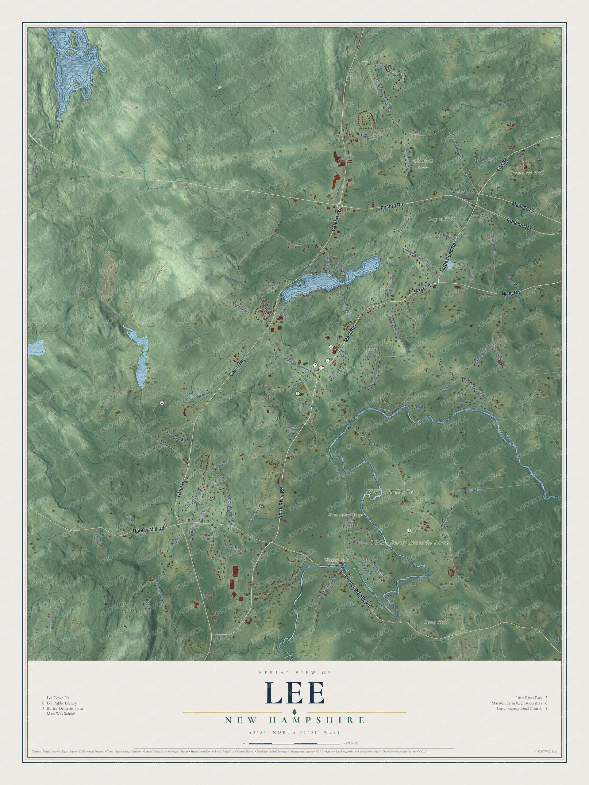
Lee, New Hampshire Map Art
Building by building, with labeled streets and shaded relief.
12" x 18" Archival Matte Print
A Map of Home. A Work of Art.
Explore Lee, New Hampshire from a whole new perspective. Created using aerial imagery and detailed geographic data, this map captures Lee building by building, with labeled streets, familiar landmarks, and shaded topographical relief that highlights the natural contours of the landscape.
Combining modern data with the timeless character of a vintage atlas, this map is just as interesting up close as it is beautiful on the wall. Whether you grew up in Lee, spent memorable years there, or call it home today, this unique map is a great way to celebrate a place that means something to you. Zoom in on the preview to look for your street, and then order a print to put your memories on the wall.
Three ways to hang it

Unframed archival matte, a black wood frame or a white wood frame.
Up close
Geography Worth Displaying
This map was created using accurate cartographic data and authoritative geographic sources, including the U.S. Geological Survey (USGS) and FEMA. The map brings together terrain, waterways, roads, and building detail. The majority of the streets are labeled, houses are accurately depicted, and the topography is derived from government sources. Combining local data with carefully composed color and shading leads to this beautifully detailed Lee artwork for your wall.
Rather than simply showing street outlines, we’ve included as many of the street names as we could reasonably fit on the map while keeping their names legible. Zoom in on the high resolution preview to see exactly what’s on the map. We truly set out to create a statement piece for anyone who loves Lee. So whether it’s for you, or a gift for someone you love, we hope this map of Lee brings back fond memories.
Explore the full map of Lee, New Hampshire and read about the local places it shows.

Find your street
Names on the Lee map
Every name below is printed on this map. Look for your street, your school, the park where you played, or the pond down the road.
Places and landmarks8
- Wadley Falls
- Glenmere Village
- Demeritt Hill
- Layne Hill
- Long Hill
- UNH - Burley Demeritt Farm
- UNH - Dudley Lot
- Old Mill Reserve
Streets and roads81
- North River Road
- Lee Road
- Mast Road
- Concord Road
- Calef Highway
- Harvey Mill Road
- Wadleigh Falls Road
- Turtle Pond Road
- Main Stree
- Snell Road
- New Town Plains Road
- Lee Hook Road
- George Bennett Road
- Old Mill Road
- Mitchell Road
- Fox Garrison Road
- Wednesday Hill Road
- Steppingstones Road
- Tuttle Road
- High Road
- Cartland Road
- Earle Drive
- Lee Hill Road
- James Farm Road
- Garrity Road
- Riverside Farm Drive
- Pinkham Road
- Jenkins Lane
- Northside Road
- Thurston Drive
Show all 81 streets
- Belle Lane
- Randall Road
- Carpenter Lane
- Campground Road
- Demeritt Avenue
- Tamarack Road
- Hobbs Road
- Toon Lane
- Birch Hill Road
- Lamprey Lane
- Sheep Road
- Jenkins Road
- Kelsey Road
- Granger Drive
- Spencer Lane
- Rita Lane
- Little Hook Road
- York Lane
- West Mill Pond Road
- Gile Road
- Sackett Road
- Chestnut Way
- Wiswall Road
- Sawyer Road
- Furber Drive
- Owl Lane
- Swaan Drive
- Plumer Lane
- Lee Fire Road N6
- Packers Falls Road
- Captain Parker Drive
- Elder Osborne Drive
- Allens Avenue
- Spruce Drive
- Jacob Lane
- Clement Way
- Orchard Way
- Lee Fire Road N7
- Hayes Road
- Decato Drive
- County Line Road
- Layne Drive
- Piper Lane
- Old Nottingham Road
- Durgin Drive
- Ellis Road
- Wheelwright Drive
- Caverno Drive
- Radford Road
- Hale Farm
- Davis Lane
Names are listed as they appear on the printed map. Zoom into the product photos to find them.
About Lee, New Hampshire
Lee is a farm town of 4,520 people in Strafford County, near the University of New Hampshire in Durham. Three rivers drain it: the Lamprey, the North and the Oyster. Europeans settled the land in 1657, when it lay inside the big early township of Dover, and in 1735 Durham broke away from Dover and took Lee along with it.
Lee remained part of Durham until January 16, 1766, when Governor Benning Wentworth made it a town of its own. It was one of the last of the 129 towns he chartered while in office. The new town was named for Charles Lee, a British general who later went over to the American side in the Revolution.
- A battle at Wheelwright PondDuring King William's War, Indians urged on by the government of New France raided Exeter on July 4, 1690. Two infantry companies raised to chase them caught up with them at Wheelwright Pond two days later. The fighting killed 3 officers and 15 soldiers, along with many Indians. The officers, all from Massachusetts Bay, were Ensign Edward Walker, Lieutenant Gershom Flagg and Captain Noah Wiswall. The pond takes its name from the Reverend John Wheelwright, who founded Exeter.
- The Parrott gun of 1860Robert Parker Parrott was born in Lee in 1804 and placed third in his West Point class of 1824. He spent three decades in charge of the West Point Foundry on the Hudson River. There, in 1860, he produced a rifled cannon, the Parrott gun, and both the Union and Confederate armies fired it in the Civil War.
- The mill dam at Wadleigh FallsThe Lamprey River flows from Northwood to Great Bay, crossing Lee as it heads east, and water-powered mills once lined its banks. At Wadleigh Falls, the remains of a dam built to run a mill still stand. Its millpond once spread across 150 acres.
- Lee Raceway, opened 1964Lee USA Speedway on Route 125 began in 1964 as Lee Raceway, a track with a dirt surface. The short oval has since hosted NASCAR events, and Dale Earnhardt and Terry Labonte have both raced on it.
- A garden on a 1740 farmBedrock Gardens covers 20 acres of a former dairy farm, where the farmhouse goes back to about 1740. Starting in 1980, its owners reshaped the land with walking trails, pools and a pond for wildlife. They planted over a thousand kinds of plants and placed sculpture by Jill Nooney, one of the founders, throughout the grounds. The garden had 12,000 visitors in 2020.
Keep exploring New Hampshire
Lee is one of 279 New Hampshire towns we've mapped. Every dot on the map is a print of its own.
The search covers every state, New Hampshire first.
Near Lee
Order 2 or more town maps and save 10%. Shown in the size and finish you picked above, so they hang as a set.
- Durham 12" x 18" / Archival Matte Print $39.99
- Newmarket 12" x 18" / Archival Matte Print $39.99
- Madbury 12" x 18" / Archival Matte Print $39.99


More maps nearby: Newfields, Epping, Nottingham, Barrington and Dover.
The art of mapping a place
How This Map Was Made
Real places. Remarkable detail. Discover the layers that turn geographic data into a map of home.

The view from above
Aerial imagery reveals the character of the land: woodland, open fields, and the patterns of a place.

The shape of the land
Elevation data brings hills, valleys, and subtle changes in the landscape into view.

The details of home
Roads, waterways, and building footprints come together to make the map feel unmistakably local.

Geography becomes art
Considered color, shading, and typography bring the layers together in a map made for your wall.


Process illustrated with Mendon, Massachusetts. Aerial imagery: USDA NAIP. Terrain: USGS 3D Elevation Program. Map details and finished artwork: KNOWOL.
The Details
About This Print
Choose an archival matte print, or a black or white Ayous wood frame. The archival matte print is unframed.
Select your size and finish above to see the matching product image and price.
Materials & Craftsmanship
A contemporary map with the character of a classic atlas, printed on archival matte paper. Optional frames are made from Ayous wood.
Your printed map does not include the watermark shown in the full-map preview.
Shipping & Delivery
Free shipping within the United States. Every print is made to order in the USA.
Buying a gift? Add a note in your cart and we'll include it. We never put prices in the package.
Prints ship within 2 to 3 business days. Allow 7 to 10 days total from ordering for delivery. Timing may vary during holidays or periods of high order volume.
Read our shipping policy.
Returns and damaged prints
Each print is made to order. Change-of-mind refunds are not available after production.
If your print arrives damaged, misprinted or incorrect, contact support@knowol.com within 30 days of receiving it. Include your order number, photos and a description of the issue.
Read our full refund and replacement policy. For questions about your order, email support@knowol.com.