
Search for another town


Free U.S. delivery 7 to 10 days after you order
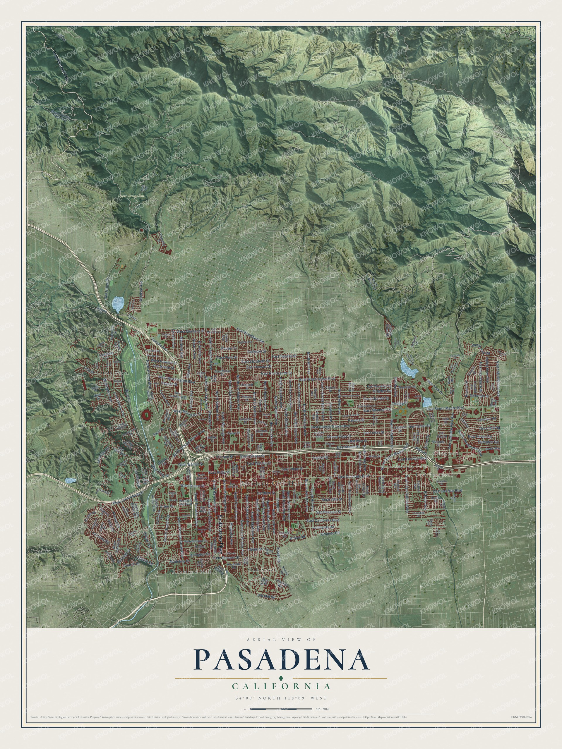
Pasadena, California Map Art
Building by building, with labeled streets and shaded relief.
12" x 18" Archival Matte Print
A Map of Home. A Work of Art.
Explore Pasadena, California from a whole new perspective. Created using aerial imagery and detailed geographic data, this map captures Pasadena building by building, with labeled streets, familiar landmarks, and shaded topographical relief that highlights the natural contours of the landscape.
Combining modern data with the timeless character of a vintage atlas, this map is just as interesting up close as it is beautiful on the wall. Whether you grew up in Pasadena, spent memorable years there, or call it home today, this unique map is a great way to celebrate a place that means something to you. Zoom in on the preview to look for your street, and then order a print to put your memories on the wall.
Three ways to hang it

Unframed archival matte, a black wood frame or a white wood frame.
Up close
Geography Worth Displaying
This map was created using accurate cartographic data and authoritative geographic sources, including the U.S. Geological Survey and the Census Bureau. The map brings together terrain, waterways, roads, and building detail. The majority of the streets are labeled, houses are accurately depicted, and the topography is derived from government sources. Combining local data with carefully composed color and shading leads to this beautifully detailed Pasadena artwork for your wall.
Rather than simply showing street outlines, we’ve included as many of the street names as we could reasonably fit on the map while keeping their names legible. Zoom in on the high resolution preview to see exactly what’s on the map. We truly set out to create a statement piece for anyone who loves Pasadena. So whether it’s for you, or a gift for someone you love, we hope this map of Pasadena brings back fond memories.
Read the story behind this map of Pasadena, California from 2026.

Find your street
Names on the Pasadena map
Every name below is printed on this map. Look for your street, your school, the park where you played, or the pond down the road.
Places and landmarks8
- Pasadena City Hall
- Chapman
- East Pasadena
- Lamanda Park
- Upper Arroyo Seco
- Raymond Hill
- Linda Vista
- Oak Knoll
Streets and roads302
- South Arroyo Parkway
- North Arroyo Boulevard
- East Colorado Boulevard
- Linda Vista Avenue
- East Corson Street
- North Fair Oaks Avenue
- West Colorado Boulevard
- East Sierra Madre Boulevard
- South Fair Oaks Avenue
- North Sierra Madre Boulevard
- Seco Street
- Corson Street
- Windsor Avenue
- North Michillinda Avenue
- East Washington Boulevard
- South Oak Knoll Avenue
- South Orange Grove Boulevard
- Oak Grove Drive
- North Orange Grove Boulevard
- South San Gabriel Boulevard
- West Mountain Street
- North Allen Avenue
- South Grand Avenue
- Forest Avenue
- Eaton Drive
- East Del Mar Boulevard
- East Orange Grove Boulevard
- East Walnut Street
- East Villa Street
- East Mountain Street
Show all 302 streets
- East Maple Street
- East California Boulevard
- East Foothill Boulevard
- North Marengo Avenue
- North Los Robles Avenue
- North Garfield Avenue
- North Raymond Avenue
- North El Molino Avenue
- Paloma Street
- North Altadena Drive
- Lincoln Avenue
- North Lake Avenue
- South El Molino Avenue
- North Catalina Avenue
- North Hill Avenue
- South Marengo Avenue
- North Michigan Avenue
- North Holliston Avenue
- Sierra Madre Villa Avenue
- North Sierra Bonita Avenue
- South Los Robles Avenue
- East Howard Street
- Las Lunas Street
- South Oakland Avenue
- North Summit Avenue
- La Loma Road
- Hastings Ranch Drive
- East Union Street
- North Mentor Avenue
- East Elizabeth Street
- North Wilson Avenue
- San Pasqual Street
- West Washington Boulevard
- South Euclid Avenue
- Cordova Street
- South Pasadena Avenue
- North Craig Avenue
- West Drive
- Glen Avenue
- Avenue 64
- Casa Grande Street
- Locust Street
- Monte Vista Street
- Lida Street
- South Madison Avenue
- South Raymond Avenue
- New York Drive
- Mentone Avenue
- Sunset Avenue
- Brigden Road
- Arden Road
- South Lake Avenue
- Atchison Street
- South Wilson Avenue
- Sinaloa Avenue
- South Hudson Avenue
- West Howard Street
- Laguna Road
- West Montana Street
- Navarro Avenue
- East Rio Grande Street
- Lombardy Road
- Riviera Drive
- North Hudson Avenue
- El Sereno Avenue
- North Rosemead Boulevard
- Valley View Avenue
- South Hill Avenue
- East Topeka Street
- East Penn Street
- Cooley Place
- East Glenarm Street
- Rose Villa Street
- Canada Avenue
- South Catalina Avenue
- Greenhill Road
- Wellington Avenue
- East Woodbury Road
- Del Rey Avenue
- West Green Street
- Cliff Drive
- West Walnut Street
- Kewen Drive
- Pepper Street
- Landfair Road
- Alpine Street
- Del Monte Street
- El Nido Avenue
- Hermanos Street
- Old Mill Road
- South Holliston Avenue
- Arlington Drive
- Burleigh Drive
- Anita Drive
- Wheeler Lane
- Hampton Road
- Ranch Top Road
- Los Altos Drive
- New Haven Road
- Madeline Drive
- Flower Street
- Magnolia Avenue
- West Holly Street
- Orlando Road
- Church Street
- East Holly Street
- Arbor Street
- Angeles Crest Highway
- South Arroyo Boulevard
- Rose Bowl Drive
- Yucca Lane
- South Sierra Madre Boulevard
- Fern Tktl
- Glen Oaks Boulevard
- Rosemont Avenue
- North Mar Vista Avenue
- North Chester Avenue
- North Madison Avenue
- North Avenue 64
- South San Rafael Avenue
- Mount Lukens Truck Trail
- Inverness Drive
- Edmondson Alley
- Bellefontaine Street
- West State Street
- East Woodlyn Road
- Lambert Drive
- Prospect Boulevard
- Hillcrest Avenue
- Clifton Alley
- West Hammond Street
- North Oak Avenue
- North Daisy Avenue
- Maple Street
- Wesley Avenue
- South Greenwood Avenue
- South Allen Avenue
- Mount Wilson Road
- North Euclid Avenue
- Hamilton Avenue
- Del Vina Street
- Daveric Drive
- Cartwright Street
- Hillside Terrace
- West Del Mar Boulevard
- Sequoia Drive
- Asbury Drive
- Palm Terrace
- South Bonnie Avenue
- Afton Street
- Allendale Road
- Shoppers Lane
- White Street
- Linda Glen Drive
- Fern Drive
- Woodlyn Road
- California Terrace
- Woodcliffe Road
- Devon Road
- Buckeye Street
- Normandy Drive
- Canyon Close Road
- Cherry Drive
- Florecita Drive
- Leonard Avenue
- South Craig Avenue
- Oneida Street
- Cornell Road
- Brixton Road
- Canon Drive
- Virginia Avenue
- Sears Way
- Arroyo Terrace
- Tierra Alta Drive
- Alameda Street
- West Union Street
- Grandview Street
- Barthe Drive
- Eastern Avenue
- Earlham Street
- Parke Street
- Eldora Road
- Prescott Street
- Hurlbut Street
- Lundy Avenue
- Marion Avenue
- Avoca Avenue
- West Villa Street
- Cedar Street
- Mead Alley
- Outpost Lane
- Rida Street
- Ridge Way
- Encino Drive
- Esther Street
- May Alley
- Iowa Avenue
- Wynn Road
- Tyler Alley
- Patrician Way
- North Pasadena Avenue
- East Green Street
- Loma Vista Street
- East Dudley Street
- Highland Street
- Wagner Street
- East Montana Street
- Stanton Street
- Bresee Avenue
- Linda Ridge Road
- Cresthaven Drive
- San Miguel Road
- South De Lacey Avenue
- Redwood Drive
- Heatherside Road
- Coniston Road
- San Marino Avenue
- Eaton Canyon Drive
- Walnut Street
- Old House Road
- North Meridith Avenue
- Wicks Road
- Canyon Wash Drive
- North Oak Knoll Avenue
- Elmira Street
- San Remo Road
- Madre Street
- Toolen Place
- Thorndike Road
- Brandon Street
- Highland Drive
- Vista Lane
- Ohio Street
- Oneida Drive
- Barker Alley
- Sidney Avenue
- Ellis Street
- Maylin Street
- Maple Way
- Hunt Alley
- North Martelo Avenue
- Queensberry Road
- Palmetto Drive
- Vista Laguna Terrace
- Holly Vista Drive
- Rexford Avenue
- Zanja Street
- South Michigan Avenue
- Rim Road
- Vista Avenue
- Chateau Road
- North Saint John Avenue
- Manford Way
- Ontario Avenue
- Veranada Avenue
- North Rose Avenue
- Morton Avenue
- La Presa Drive
- Dark Canyon Road
- Congress Street
- Fairpoint Street
- Skycrest Drive
- Mesita Road
- Edgehill Place
- Lagunita Road
- Merrett Drive
- Yale Street
- Banyan Street
- Boston Court
- Ashley Drive
- Madia Street
- Ford Place
Names are listed as they appear on the printed map. Zoom into the product photos to find them.
About Pasadena, California
Pasadena is a city of 138,699 people in Los Angeles County, about 10 miles northeast of downtown Los Angeles. The Hahamog-na, a branch of the Tongva Nation, are the earliest people known to have lived here. In the Mexican era most of the land became Rancho del Rincon de San Pascual, named because it was deeded to Eulalia Perez de Guillén Mariné on Easter Sunday. Its last Mexican owner, Manuel Garfias, later sold much of it to Benjamin Wilson, a former mayor of Los Angeles.
In 1873 Dr. Daniel M. Berry of Indiana came to Wilson's ranch looking for a mild place to bring his patients, most of whom had breathing troubles. Berry, an asthmatic himself, slept better here than anywhere, so he raised money by selling stock, and on January 31, 1874, the newcomers incorporated the Indiana Colony. They chose Pasadena, an Ojibwe word for valley, as its name. The colony and Wilson's Lake Vineyard grew side by side for more than ten years, then merged, and Pasadena was incorporated on June 19, 1886.
- A secret called MuscatBerry wanted to keep his discovery quiet while he gathered settlers, so he used the code name "Muscat," after the grape Wilson grew. Once the colonists bought their land along the Arroyo Seco, Wilson gave them 2,000 acres of highland that seemed useless at the time, and part of it later became Altadena.
- A winter resort for EasternersWhen Santa Fe trains began stopping at the downtown depot in 1887, a real estate boom followed, and wealthy Easterners came to spend their winters here. The first big hotel, the Raymond, opened in 1886 on Bacon Hill, which was renamed Raymond Hill. Its 200 rooms burned on Easter morning of 1895, it was rebuilt in 1903, and it came down during the Great Depression. The Hotel Green survived and has been a co-op since 1926.
- Home of Greene and GreeneThe architects Greene and Greene shaped the American Craftsman style in Pasadena, and many of the houses they designed still stand. The Robert R. Blacker House, one of their grandest bungalows, is a California Historical Landmark and is listed on the National Register.
- California's first freewayIn 1940 the Arroyo Seco Parkway opened as the first freeway in California, tying Pasadena to downtown Los Angeles. By then Pasadena ranked as the state's eighth-largest city, and many people thought of it as a twin city to Los Angeles.
- Two parades a yearEach New Year's Day the Tournament of Roses Parade and the Rose Bowl game come to Pasadena, and the stadium sits in the Arroyo Seco. When property values fell in the city's hard years, local artists moved in, and in 1976 they started the Doo Dah Parade.
Keep exploring California
Pasadena is one of 1,990 California towns we've mapped. Every dot on the map is a print of its own.
The search covers every state, California first.
Near Pasadena
Order 2 or more town maps and save 10%. Shown in the size and finish you picked above, so they hang as a set.
- Bungalow Heaven 12" x 18" / Archival Matte Print $39.99
- Altadena 12" x 18" / Archival Matte Print $39.99
- Madison Heights 12" x 18" / Archival Matte Print $39.99


More maps nearby: Oak Knoll, San Pasqual, San Marino, South Pasadena and East Pasadena.
The art of mapping a place
How This Map Was Made
Real places. Remarkable detail. Discover the layers that turn geographic data into a map of home.

The view from above
Aerial imagery reveals the character of the land: woodland, open fields, and the patterns of a place.

The shape of the land
Elevation data brings hills, valleys, and subtle changes in the landscape into view.

The details of home
Roads, waterways, and building footprints come together to make the map feel unmistakably local.

Geography becomes art
Considered color, shading, and typography bring the layers together in a map made for your wall.


Process illustrated with Mendon, Massachusetts. Aerial imagery: USDA NAIP. Terrain: USGS 3D Elevation Program. Map details and finished artwork: KNOWOL.
The Details
About This Print
Choose an archival matte print, or a black or white Ayous wood frame. The archival matte print is unframed.
Select your size and finish above to see the matching product image and price.
Materials & Craftsmanship
A contemporary map with the character of a classic atlas, printed on archival matte paper. Optional frames are made from Ayous wood.
Your printed map does not include the watermark shown in the full-map preview.
Shipping & Delivery
Free shipping within the United States. Every print is made to order in the USA.
Buying a gift? Add a note in your cart and we'll include it. We never put prices in the package.
Prints ship within 2 to 3 business days. Allow 7 to 10 days total from ordering for delivery. Timing may vary during holidays or periods of high order volume.
Read our shipping policy.
Returns and damaged prints
Each print is made to order. Change-of-mind refunds are not available after production.
If your print arrives damaged, misprinted or incorrect, contact support@knowol.com within 30 days of receiving it. Include your order number, photos and a description of the issue.
Read our full refund and replacement policy. For questions about your order, email support@knowol.com.