


Search for another town


Free U.S. delivery 7 to 10 days after you order
Pontiac, South Carolina Map Art
Building by building, with labeled streets and shaded relief.
12" x 18" Archival Matte Print
A Map of Home. A Work of Art.
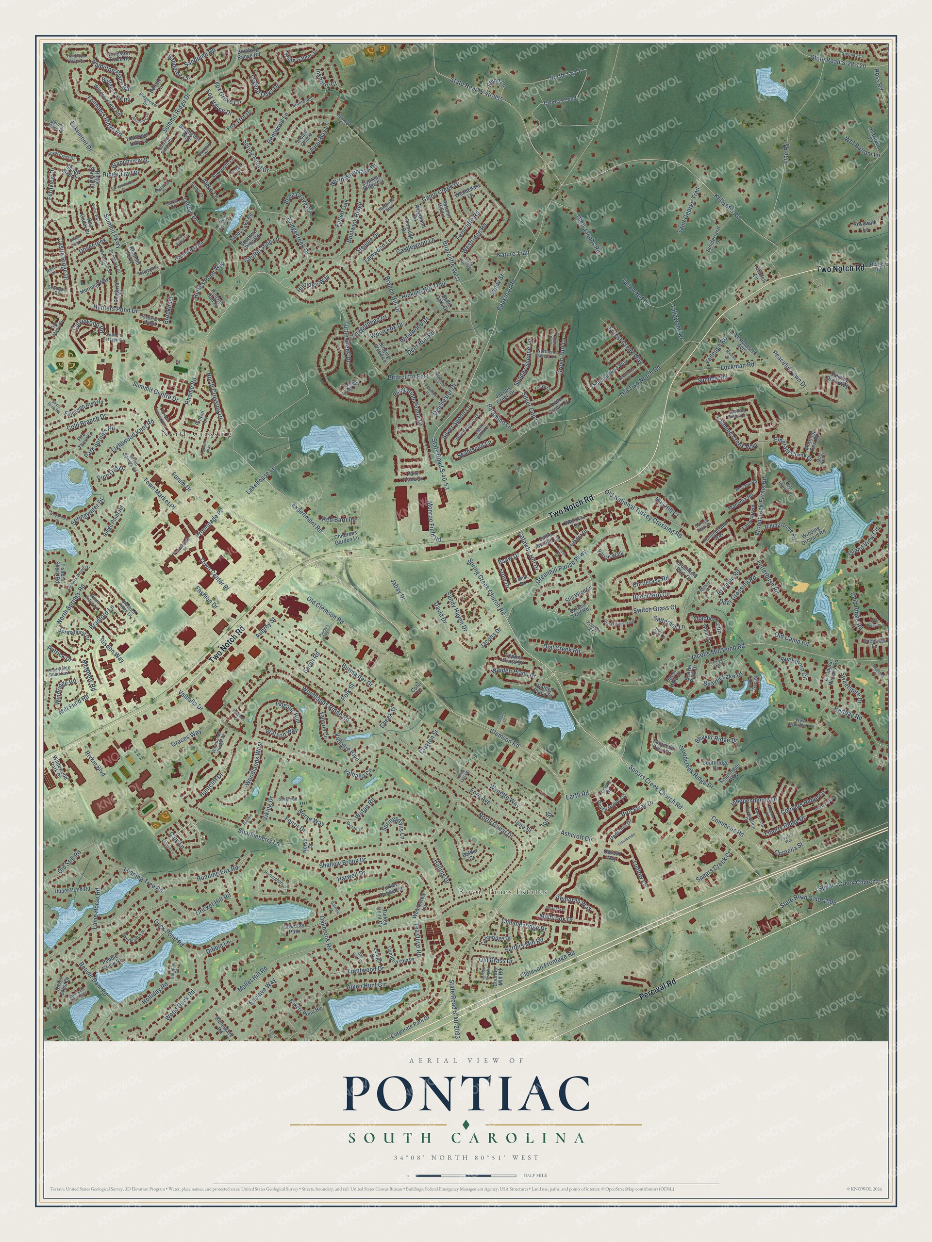
Explore Pontiac, South Carolina from a whole new perspective. Created using aerial imagery and detailed geographic data, this map captures Pontiac building by building, with labeled streets, familiar landmarks, and shaded topographical relief that highlights the natural contours of the landscape.
Combining modern data with the timeless character of a vintage atlas, this map is just as interesting up close as it is beautiful on the wall. Whether you grew up in Pontiac, spent memorable years there, or call it home today, this unique map is a great way to celebrate a place that means something to you. Zoom in on the preview to look for your street, and then order a print to put your memories on the wall.
Three ways to hang it

Unframed archival matte, a black wood frame or a white wood frame.
Up close
Geography Worth Displaying
This map was created using accurate cartographic data and authoritative geographic sources, including the U.S. Geological Survey and the Census Bureau. The map brings together terrain, waterways, roads, and building detail. The majority of the streets are labeled, houses are accurately depicted, and the topography is derived from government sources. Combining local data with carefully composed color and shading leads to this beautifully detailed Pontiac artwork for your wall.
Rather than simply showing street outlines, we’ve included as many of the street names as we could reasonably fit on the map while keeping their names legible. Zoom in on the high resolution preview to see exactly what’s on the map. We truly set out to create a statement piece for anyone who loves Pontiac. So whether it’s for you, or a gift for someone you love, we hope this map of Pontiac brings back fond memories.
Read the story behind this map: Detailed Map of Pontiac, South Carolina.

Find your street
Names on the Pontiac map
Every name below is printed on this map. Look for your street, your school, the park where you played, or the pond down the road.
Places and landmarks3
- Royal Pines Estates
- North Crossing
- Cowdray Park
Streets and roads387
- Two Notch Road
- Percival Road
- Clemson Road
- Spears Creek Church Road
- Bridgecreek Drive
- Rhame Road
- Spring Creek Church Road
- Experiment Road
- Woodlands Ridge Road
- Mill Field Road
- Enclave Way
- Liberty Ridge Drive
- Town Center Place
- State Road S-40-2033
- Palamino Lane
- State Road S-40-53
- Jacobs Mill Pond Road
- Plantation Pointe Drive
- Bookman Road
- Sparkleberry Lane
- Woodcreek Farms Road
- Summit Parkway
- Kelly Mill Road
- State Road S-40-955
- Valhalla Drive
- Fore Avenue
- Burmaster Drive
- Wynette Way
- Mallet Hill Road
- Old Two Notch Road
Show all 387 streets
- Cold Branch Drive
- Westridge Road
- Wotan Road
- North Springs Road
- Hunters Pond Drive
- Aiken Hunt Circle
- Running Fox Road
- North Jay Drive
- Ridge Trail Drive
- Briarcliffe West
- Beechfern Circle
- Forum Drive
- Legion Drive
- Summit Ridge Drive
- North Donar Drive
- Fashion Drive
- Camp Creek Drive
- Oakbrook Road
- Sundew Road
- Leaning Tree Road
- Greenhill Parish Parkway
- Legend Oaks Drive
- Line Road
- Redbay Road
- Ashcroft Circle
- Risdon Way
- Clemson Frontage Road
- Jabay Drive
- Sandpine Circle
- Shallow Brook Drive
- Ferncliffe Road
- Old National Turkey Crossing Road
- North Crossing Drive
- Old Clemson Road
- Loggerhead Drive
- Beaver Dam Road
- Bostwick Ridge
- Lame Horse Road
- Hogans Run
- Island View Circle
- North Woodlake Drive
- Fox Trot Drive
- Fetterbush Road
- Ione Street
- Wood Duck Road
- Wood Fox Drive
- Duck Pond Road
- Bentwood Lane
- Founders Ridge Road
- State Road S-28-120
- Town Market Place
- Tallawood Lane
- Fallen Oak
- Cricket Hill Road
- Castle Ridge Drive
- Summit Centre Drive
- Briarcliffe East
- Spring Point Drive
- Lockman Road
- Green Turf Lane
- Viking Drive
- Heises Pond Way
- Huntcliff Drive
- Turtle Creek Drive
- Holliday Road
- Woodcreek Ridge Drive
- Branch Hill Drive
- Sandy Haven Drive
- Rivkin Boulevard
- Park Springs Road
- Spears Creek Church Lane
- Old Camp Road
- Castlewood Lane
- Brockway Drive
- Deer Run Road
- Fox Grove Circle
- Springwater Drive
- Old Brass Drive
- Trentwood Drive
- Dial Creek Road
- Nature Trail
- Deer Crossing Road
- Harwell Drive
- Sutters Mill Road
- Lightwood Knot Road
- Graces Way
- Woodlands West
- Emerald Creek Drive
- State Road S-40-1098
- Bradford Lane
- Coulter Pine Lane
- Steeple Drive
- Belle Grove Circle
- Delchester Drive
- Forest Creek Way
- Branchview Drive
- Curvewood Road
- Walden Place Drive
- Glen Jacobs Road
- Tamwood Lane
- Hickory Hill Trail
- Red Barn Road
- Earth Road
- Beaver Lake Drive
- Vallenga Road
- Lakemont Drive
- Halling Drive
- Hillridge Way
- Sandpine Road
- Windwood Drive
- Wet Bottom Lane
- Lakehouse Lane
- Beaver Ridge Drive
- Sweetspire Drive
- Club Ridge Road
- Monroe Field Road
- Ludlow Lane
- Cordgrass Road
- Fernview Drive
- Midbrook Drive
- Old Still Road
- Thacher Loop
- Silver Spoon Lane
- Calming Creek Way
- Bramble Road
- Saint George Trail
- Commons Road
- Hamilton Place Road
- Chimneyridge Drive
- Semoran Way
- Springsdans Lane
- Valkyrie Boulevard
- Sunday Silence Lane
- Hay Hill Court
- Dovecreek
- Buckthorn Circle
- Peaceful Fawn Drive
- Tea Olive Road
- Valhalla Circle
- Cornelia Street
- Coopers Ridge Lane
- Jacobs Drive
- Fox Haven Drive
- Spears Creek Court
- Norse Way
- Independence Drive
- Sandy Street
- Inkberry Court
- Silver Cup Lane
- Switch Grass Court
- Catawba Hill Drive
- Tallawood Drive
- Fenrir Drive
- Laurel Bay Lane
- Flynn Lane
- Ross Road
- Prominade Place
- Brookmist
- Alelia Lane
- Watson Way
- Seabiscuit Lane
- Windridge Road
- Dibble Lane
- Pine Oak Drive
- McNeely Road
- Saltgrass Lane
- Esaw Drive
- David Drive
- Patrick Drive
- Frow Drive
- Aubrey Street
- Cheek Street
- Clayton Street
- Polk Street
- Sarah Road
- Ion Street
- Cam Lane
- Upland Trail Road
- Still Wind Lane
- Babington Way
- Grandview Circle
- Cypress Pond
- Corporate Park Drive
- Kingston Trace Road
- Park Place Drive
- Pebble Creek Road
- Upper Pond Road
- Southridge Way
- Coopers Nursery Road
- Parish Walk
- Peach Grove Circle
- Ridge Point Road
- Turkey Point Circle
- Morning Way
- Turkey Pointe Circle
- Mahonia Road
- Jacobs Creek Drive
- Pepper Grass Drive
- Childrens Garden Lane
- Thoroughbred Way
- Riding Grove Road
- Ricemill Ferry
- Beaver Park Drive
- Valkyrie Circle
- Autumn Hill Lane
- Sunderland Drive
- Springhurst Drive
- Rosewalk Lane
- Pintail Lane
- Camden Chase
- Hodson Hall Drive
- Windsorcrest Road
- Winding Orchard Road
- Bombing Range Road
- Westchester Avenue
- Southern Pine Road
- Brittany Park Road
- White Gables Drive
- Underhill Drive
- Falmouth Rise Road
- Heartland Drive
- Calming Dusk Way
- Ridge Spring Drive
- Bakers Point Road
- Shady Mist Drive
- Country Mill Road
- Woodsview Lane
- Sawtooth Lane
- Cypress Ridge Circle
- Sandy Lake Road
- Lacecap Road
- Fire Thorn Lane
- Founders Lake Court
- Singing Wood Lane
- Brushfield Park Drive
- Centeridge Drive
- Southridge Drive
- Triple Crown Court
- Fishers Shore Road
- Indigo Chase
- Belleclave Road
- Sallie Gordon Lane
- Norse Drive
- Sunridge Drive
- Durwin Way
- Silver Crest Drive
- Upper Lake Drive
- Summerland Way
- Belle Oaks Drive
- Gillon Lane
- Stagbriar Court
- Woodchase Lane
- Buckview Lane
- Wildewood Park Drive
- Top View Lane
- Red Cedar Drive
- Ridgeland Road
- Magnolia Petal Drive
- Morning Dew Road
- Lakota Drive
- Wallowa Drive
- Lehigh Court
- Walden Place Court
- Brazell Lane
- Tonsi Drive
- Leisure Drive
- Baldur Court
- Bolette Lane
- Blaney Road
- Cohn Drive
- Buckeye Court
- Summit Ridge Circle
- Mossy Lane
- Turtle Creek Way
- Brentwood Lane
- Hamilton Place Circle
- Summit Terrace Court
- Bradford Ridge Lane
- Northern Dancer Lane
- Cattle Baron Lane
- Oak Manor Drive
- Piedmont Ridge
- Ridgeview Drive
- Pond Ridge Road East
- Grand National Lane
- Thornhill Drive
- Seven Springs Road
- Fishers Wood Drive
- Pocosin Court
- Beaver Lake Court
- North Trace Lane
- Barony Place Drive
- Hurlingham Drive
- Royal Crest Drive
- Wheatstone Court
- Overbranch Drive
- Declaration Drive
- Woodlands Village Drive
- Bustling Branch Lane
- West Arrowleaf Lane
- Tamwood Way
- Siegfried Lane
- Birchbark Court
- McCabe Road
- Promenade Place
- Spinney Court
- Stablegate Court
- Southport Drive
- Acuba Court
- Lucky Court
- Wotan Lane
- Clerya Court
- Holliday Court
- Holly Fern Lane
- Earnest Leen Drive
- Jacobs Mill Court
- Giant Feather Loop
- Club Ridge Court
- Pineclave Circle
- Clearmeadow Drive
- Summit Townes Way
- Tamara Way
- Ringwood Lane
- Woodshore Drive
- London Gray Drive
- Viewmont Road
- Ardennes Drive
- Tuxford Trail
- Secretariat Drive
- Clairmeade
- Montford Drive
- Mystic Way Drive
- Silver Lake Road East
- Ash Ridge Court
- Nassau Drive
- Day Lily Way
- South Brick Road
- Corinth Court
- Paupers Lane
- Bluestem Drive
- Derby Downs Court
- Oak Bluff Court
- Mapleleaf Drive
- Quality Court
- Solandra Drive
- Malisa Drive
- Talltree Lane
- Ridge Pond Drive
- Brassie Court
- Lexington Pointe Drive
- Camp Creek Court
- Senegal Lane
- Spyglass Court
- Ellery Court
- Casa Loma Street
- Gatwick Court
- Misty Path Drive
Names are listed as they appear on the printed map. Zoom into the product photos to find them.
Keep exploring South Carolina
Pontiac is one of 540 South Carolina towns we've mapped. Every dot on the map is a print of its own.
The search covers every state, South Carolina first.
Near Pontiac
Order 2 or more town maps and save 10%. Shown in the size and finish you picked above, so they hang as a set.
- North Springs 12" x 18" / Archival Matte Print $39.99
- Elgin 12" x 18" / Archival Matte Print $39.99
- Killian 12" x 18" / Archival Matte Print $39.99


More maps nearby: Spring Valley, Woodfield, Columbia, Dentsville and Arcadia Lakes.
The art of mapping a place
How This Map Was Made
Real places. Remarkable detail. Discover the layers that turn geographic data into a map of home.

The view from above
Aerial imagery reveals the character of the land: woodland, open fields, and the patterns of a place.

The shape of the land
Elevation data brings hills, valleys, and subtle changes in the landscape into view.

The details of home
Roads, waterways, and building footprints come together to make the map feel unmistakably local.

Geography becomes art
Considered color, shading, and typography bring the layers together in a map made for your wall.


Process illustrated with Mendon, Massachusetts. Aerial imagery: USDA NAIP. Terrain: USGS 3D Elevation Program. Map details and finished artwork: KNOWOL.
The Details
About This Print
Choose an archival matte print, or a black or white Ayous wood frame. The archival matte print is unframed.
Select your size and finish above to see the matching product image and price.
Materials & Craftsmanship
A contemporary map with the character of a classic atlas, printed on archival matte paper. Optional frames are made from Ayous wood.
Your printed map does not include the watermark shown in the full-map preview.
Shipping & Delivery
Free shipping within the United States. Every print is made to order in the USA.
Buying a gift? Add a note in your cart and we'll include it. We never put prices in the package.
Prints ship within 2 to 3 business days. Allow 7 to 10 days total from ordering for delivery. Timing may vary during holidays or periods of high order volume.
Read our shipping policy.
Returns and damaged prints
Each print is made to order. Change-of-mind refunds are not available after production.
If your print arrives damaged, misprinted or incorrect, contact support@knowol.com within 30 days of receiving it. Include your order number, photos and a description of the issue.
Read our full refund and replacement policy. For questions about your order, email support@knowol.com.