
Search for another town




Free U.S. delivery 7 to 10 days after you order
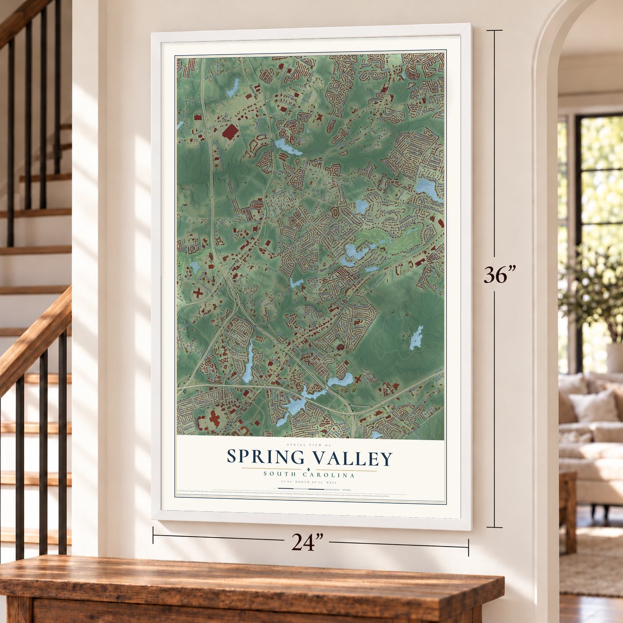
Spring Valley, South Carolina Map Art
Building by building, with labeled streets and shaded relief.
12" x 18" Archival Matte Print
A Map of Home. A Work of Art.
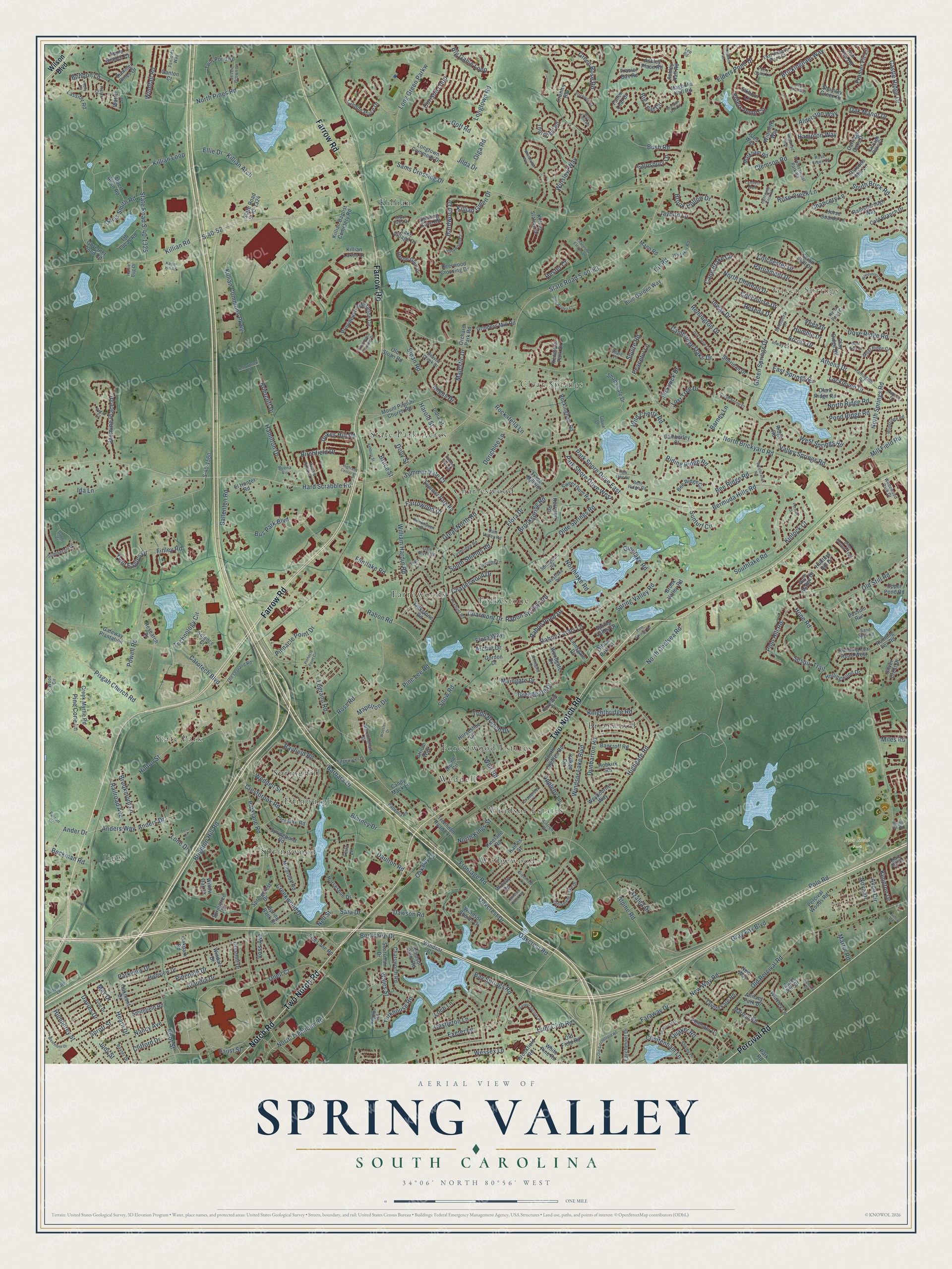
Explore Spring Valley, South Carolina from a whole new perspective. Created using aerial imagery and detailed geographic data, this map captures Spring Valley building by building, with labeled streets, familiar landmarks, and shaded topographical relief that highlights the natural contours of the landscape.
Combining modern data with the timeless character of a vintage atlas, this map is just as interesting up close as it is beautiful on the wall. Whether you grew up in Spring Valley, spent memorable years there, or call it home today, this unique map is a great way to celebrate a place that means something to you. Zoom in on the preview to look for your street, and then order a print to put your memories on the wall.
Three ways to hang it
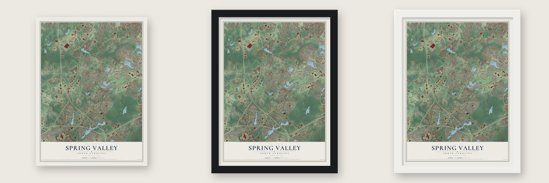
Unframed archival matte, a black wood frame or a white wood frame.
Up close
Geography Worth Displaying
This map was created using accurate cartographic data and authoritative geographic sources, including the U.S. Geological Survey and the Census Bureau. The map brings together terrain, waterways, roads, and building detail. The majority of the streets are labeled, houses are accurately depicted, and the topography is derived from government sources. Combining local data with carefully composed color and shading leads to this beautifully detailed Spring Valley artwork for your wall.
Rather than simply showing street outlines, we’ve included as many of the street names as we could reasonably fit on the map while keeping their names legible. Zoom in on the high resolution preview to see exactly what’s on the map. We truly set out to create a statement piece for anyone who loves Spring Valley. So whether it’s for you, or a gift for someone you love, we hope this map of Spring Valley brings back fond memories.
Read the story behind this map: Detailed Map of Spring Valley, South Carolina.

Find your street
Names on the Spring Valley map
Every name below is printed on this map. Look for your street, your school, the park where you played, or the pond down the road.
Places and landmarks18
- Green Springs
- Polo Road Park
- Jiggs
- Wedgewood
- Killian
- State Park
- Briarwood
- Clear Springs
- Charleswood
- Farrowoods
- Forestwood Estates
- Edinburgh
Show all 18 places
- Springwood
- State Park Acres
- Windsor Estates
- Folkestone
- Springhill
- Weddell
Streets and roads437
- Farrow Road
- Two Notch Road
- Percival Road
- Notch Road
- Anders Drive
- Ander Drive
- Spring Valley Road
- Green Springs Drive
- Cane Brake Circle
- Anders Way
- Southlake Road
- Kinlock Court
- North Brickyard Road
- Bermuda Hills Road
- Sesqui Trail
- Beckman Road
- Berkshire Drive
- Oak Manor Drive
- North Chateau Drive
- Rabon Springs Road
- Hard Scrabble Road
- State Road S-40-83
- Clemson Road
- Polo Road
- Killian Road
- Windsor Lake Boulevard
- Alpine Road
- Flora Drive
- Parklane Road
- Sloan Road
Show all 437 streets
- Rabon Road
- Legrand Road
- Powell Road
- Old Percival Road
- North Trenholm Road
- Northlake Road
- North Pines Road
- Longtown Road
- Olde Springs Road
- Claudia Drive
- Oneil Court
- Ross Road
- Hunt Club Road
- Valley Springs Road
- Barbara Drive
- Dove Ridge Road
- North Springs Road
- S-40-52
- Winslow Way
- North Chelsea Road
- East Springs Road
- Faraway Drive
- Great North Road
- William Hardin Road
- Highgate Road
- Bee Ridge Road
- Brickingham Way
- Killian Commons Parkway
- Technology Circle
- Riding Ridge Road
- Oakcrest Drive
- Parkview Drive
- Green Rose Road
- Killian Loop
- State Road S-40-1325
- Hinton Street
- Briercliff Drive
- Rose Creek Lane
- Pisgah Church Road
- Pinedale Drive
- Brookspring Road
- Bay Springs Road
- Long Green Parkw
- Frontage Road
- Bus Park Boulevard
- Old Still Road
- Bayfield Road
- Brook Hollow Drive
- Avon Circle
- Rabon Pond Drive
- Athena Drive
- West Springs Road
- Brighton Hill Road
- Summer Vale Court
- Exeter Lane
- South Shields Road
- Alderston Way
- Creekwood Drive
- Carotech Boulevard
- Hardwood Drive
- Hope Road
- Arcola Drive
- Knightbridge Road
- Greengate Drive
- Flintlake Road
- Jasmine Place Drive
- Hearn Drive
- Pine Cone Lane
- Gray Fox Boulevard
- Remington Drive
- Nancy Avenue
- Dunbarton Road
- Blarney Drive
- Davies Drive
- Rabon Farms Lane
- Loch Lane
- Bruce Street
- Big Game Loop
- Park Shore Drive East
- Maingate Drive
- Ida Lane
- Cheltenham Lane
- New Way Road
- Chancery Lane
- Jilda Drive
- Killian Arch
- Elders Pond Drive
- Castle Ridge Drive
- Park Shore Drive West
- Pinnacle Point Drive
- Elders Pond Circle
- Todd Branch Drive
- Polo Hill Road
- Brookmont Lane
- Roof Street
- Lost Tree Drive
- Crestbrook Road
- Inway Drive
- Oakway Drive
- Tat Road
- Angus Drive
- Wessex Lane
- Humphrey Street
- Pine Lee Road
- Faust Street
- Cambridge Oaks Drive
- Castleton Lane
- North Ridge Road
- Jaybird Lane
- Weddell Street
- Bonbon Lane
- Sams Crossing Drive
- Big Leaf Circle
- Hamilton Drive
- Colchester Drive
- Parliament Drive
- Wild Cherry Road
- Daulton Road
- Appleby Lane
- Bush Road
- Salusbury Lane
- Birchfield Drive
- Sara Drive
- Charleswood Drive
- Windfall Road
- Dolly Street
- Reseda Drive
- Mill Field Road
- Glenlake Road
- Sunturf Circle
- Ballenton Road
- Twin Eagles Drive
- Weir Road
- Killian Green Drive
- Sprott Street
- Frasier Fir Lane
- Davis Smith Road
- Yorkhouse Road
- Lockleven Drive
- Pond Ridge Road
- Mapelton Drive
- Concourse Drive
- South Brick Road
- Railroad Avenue
- Farrowood Drive
- Dukes Hill Road
- Pickwick Drive
- Dawson Road
- Rockafella Lane
- Corison Loop
- Charmont Drive
- Wales Street
- Azalea Drive
- Kimpton Drive
- Majestic Drive
- North Kings Street
- Lone Drive
- Harold Street
- Olga Road
- Dorichlee Lane
- Flora Way
- Clifford Drive
- Judy Street
- Squire Road
- Quaker Road
- Hampton Way
- Martin Road
- Finley Road
- Oakcrest Road
- Peaceful Lane
- Hester Court
- Barney Lane
- Humble Drive
- Ellie Drive
- Snow Road
- Voss Avenue
- Miles Road
- Vega Drive
- Archie Drive
- Goff Road
- Nell Street
- Nova Drive
- May Drive
- Wilson Boulevard
- Willow Oak Drive
- Atrium Way
- Mount Pilgrim Church Road
- Ridge Road
- Governer Pond Road
- Chatsworth Road
- Horseshoe Circle
- Folkstone Road
- South Chelsea Road
- Horseshoe Drive
- Killian Lakes Drive
- Landon Place Drive
- Lionsgate Drive
- Rockingham Road
- Sheridan Drive
- Rainsborough Way
- Seton Hall Drive
- Springtree Drive
- Cold Branch Drive
- Carriage Oaks Drive
- Highview Drive
- Creek Myrtle Road
- Whixley Lane
- State Road S-40-1324
- Millbrook Road
- Fallen Leaf Drive
- Percival Woods Road
- Albert Allen Road
- Trader Mill Road
- Wiltshire Way
- Providence Plantation Circle
- Longtown Commons Drive
- Kenmore Park Drive
- Twin Pond Road
- Lake Village Drive
- Shamley Green Drive
- Summer Pines Drive
- Thornfield Road
- Windsor Point Road
- Trenholm Road Extension
- Bancroff Road
- Mann Road
- Springpond Road
- Scotsman Drive
- Science Court
- Frasier Bay Road
- Heron Glen Drive
- Windsor Shores Drive
- Running Fox Road West
- Deerwood Crossing Drive
- Horse Guards Lane
- Blue Garden Way
- Sweet Gum Road
- Running Fox Road
- Killian Station Drive
- Brook Valley Road
- Shady Vale Drive
- Tavern Fare Road
- Candy Mack Lane
- Kerryton Road
- Ashley Hall Road
- Markham Road
- Summer Park Road
- Pinelake Road
- Old Sloan Road
- Hobkirk Road
- Grinders Mill Road
- Clark Ridge Road
- India Street
- Hollingwood Drive
- Marbun Road
- Cranley Road
- Brookfield Road
- Woodgate Drive
- Ashley Place Road
- Magnolia Hall Road
- El Hunter Road
- Bee Ridge Circle
- Windsor Cv
- Weybourne Way
- Gateway Plantation
- Killian Baptist Cemetery Road
- Pinelane Road
- Watts Lane
- Lib Lucas Road
- Larchmont Drive
- Possum Run
- Springcrest Drive
- Fire Lane Road
- Upper Pond Road
- Research Drive
- Raines Street
- Smithfield Road
- Clay Ridge Road
- Spring Valley Court
- Alpine Circle
- Annacy Park Drive
- Philmont Drive
- Parsons Mill Lane
- Spring Bank Drive
- Camberley Court
- Sterling Cove Road
- Oakmont Drive
- Lassiter Road
- Ash Tree Road
- Park Road
- Ganton Court
- Kilkee Circle
- Cresthill Drive
- Orchard Park Road
- White Pine Road
- Windale Drive
- Carol Ann Drive
- Polo Ridge Drive
- S-40-1560
- Silver Crest Drive
- Isles Way
- Old Field Road
- Elkhorn Lane
- Apple Branch Court
- Hunters Hill Drive
- Gordon Drive
- Wincay Road
- Oakpark Road
- Office Park Court
- New Way
- Leila Lane
- Millet Ridge Court
- Arbor Falls Drive
- Edgewater Drive
- Parliament Lake Drive
- Firebridge Road
- Harrington Road
- Rockhaven Drive
- Royalgate Drive
- Aintree Drive
- Summerhill Drive
- Corporate Lane
- Beaver Creek Drive
- Jessie Brown Lane
- Springlawn Road
- Bagpipe Road
- Foxhunt Road
- Deer Hound Trail
- Old Legrand Road
- Allans Mill Drive
- Shelby Drive
- Whitaker Road
- Hardwood Court
- Farrow Pointe Lane
- Rose Creek Court
- Windridge Road
- Matchingham Drive
- Wood Circle
- Carriage Oaks Court
- East Waverly Place Court
- Faison Drive
- Ballemia Road
- June Drive
- Professional Park Road
- Penfolds Way
- Westlake Road
- Baxter Drive
- Cranbrook Lane
- Patrick Drive
- Inway Court
- Splendora Drive
- Dawning Lane
- Gale River Road
- Wildewood Park Drive
- Perry Oaks Lane
- Petal Court
- Heron Pond Court
- Dale Valley Road
- Bent Ridge Road
- Shale Lane
- Sand Spur Road
- Lee Road
- Hallie Bug Drive
- Ralph Court
- Buena Vis
- Finn Court
- Woodshore Drive
- Whitehurst Way
- Oak Creek Circle
- Old Satchelford Road
- Stonegate Drive
- Greenfield Road
- Ashbury Street
- Pennfield Drive
- Highland Center Drive
- Westmore Drive
- Tarpon Springs Road
- Moss Field Road
- Lambeth Walk
- Wild Azalea Court
- Charleston Estates Lane
- Pinnacle Point Circle
- Wooster Drive
- Formby Drive
- Westbranch Road
- Summer Vista Drive
- Deer Pass Way
- Yellowbrick Road
- Park Lake Road
- Green Spring Court
- Brandon Hall Road
- Pine Springs Road
- Kendrick Road
- Providence Crossing Drive
- Stockport Road
- Tabard Lane
- Kaiser Hill Road
- Lightwood Knot Road
- Inglesby Drive
- Windsor Brook Road
- Newstead Rise
- Mallet Hill Road
- Terri Lane
- Gobbi Court
- Deer Trail Court
- Quincy Road
- Kelly Court
Names are listed as they appear on the printed map. Zoom into the product photos to find them.
Keep exploring South Carolina
Spring Valley is one of 540 South Carolina towns we've mapped. Every dot on the map is a print of its own.
The search covers every state, South Carolina first.
Near Spring Valley
Order 2 or more town maps and save 10%. Shown in the size and finish you picked above, so they hang as a set.
- Killian 12" x 18" / Archival Matte Print $39.99
- Dentsville 12" x 18" / Archival Matte Print $39.99
- North Springs 12" x 18" / Archival Matte Print $39.99


More maps nearby: Woodfield, Arcadia Lakes, Pontiac, Columbia and Forest Acres.
The art of mapping a place
How This Map Was Made
Real places. Remarkable detail. Discover the layers that turn geographic data into a map of home.

The view from above
Aerial imagery reveals the character of the land: woodland, open fields, and the patterns of a place.

The shape of the land
Elevation data brings hills, valleys, and subtle changes in the landscape into view.

The details of home
Roads, waterways, and building footprints come together to make the map feel unmistakably local.

Geography becomes art
Considered color, shading, and typography bring the layers together in a map made for your wall.


Process illustrated with Mendon, Massachusetts. Aerial imagery: USDA NAIP. Terrain: USGS 3D Elevation Program. Map details and finished artwork: KNOWOL.
The Details
About This Print
Choose an archival matte print, or a black or white Ayous wood frame. The archival matte print is unframed.
Select your size and finish above to see the matching product image and price.
Materials & Craftsmanship
A contemporary map with the character of a classic atlas, printed on archival matte paper. Optional frames are made from Ayous wood.
Your printed map does not include the watermark shown in the full-map preview.
Shipping & Delivery
Free shipping within the United States. Every print is made to order in the USA.
Buying a gift? Add a note in your cart and we'll include it. We never put prices in the package.
Prints ship within 2 to 3 business days. Allow 7 to 10 days total from ordering for delivery. Timing may vary during holidays or periods of high order volume.
Read our shipping policy.
Returns and damaged prints
Each print is made to order. Change-of-mind refunds are not available after production.
If your print arrives damaged, misprinted or incorrect, contact support@knowol.com within 30 days of receiving it. Include your order number, photos and a description of the issue.
Read our full refund and replacement policy. For questions about your order, email support@knowol.com.