


Search for another town


Free U.S. delivery 7 to 10 days after you order
Prattville, Alabama Map Art
Building by building, with labeled streets and shaded relief.
12" x 18" Archival Matte Print
A Map of Home. A Work of Art.
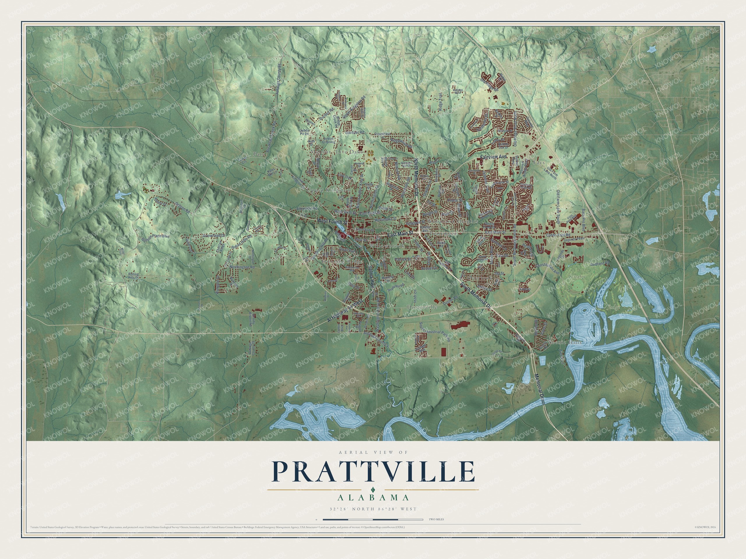
Explore Prattville, Alabama from a whole new perspective. Created using aerial imagery and detailed geographic data, this map captures Prattville building by building, with labeled streets, familiar landmarks, and shaded topographical relief that highlights the natural contours of the landscape.
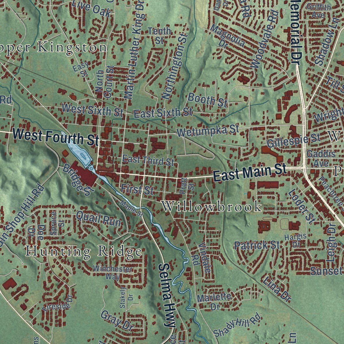
Combining modern data with the timeless character of a vintage atlas, this map is just as interesting up close as it is beautiful on the wall. Whether you grew up in Prattville, spent memorable years there, or call it home today, this unique map is a great way to celebrate a place that means something to you. Zoom in on the preview to look for your street, and then order a print to put your memories on the wall.
Three ways to hang it
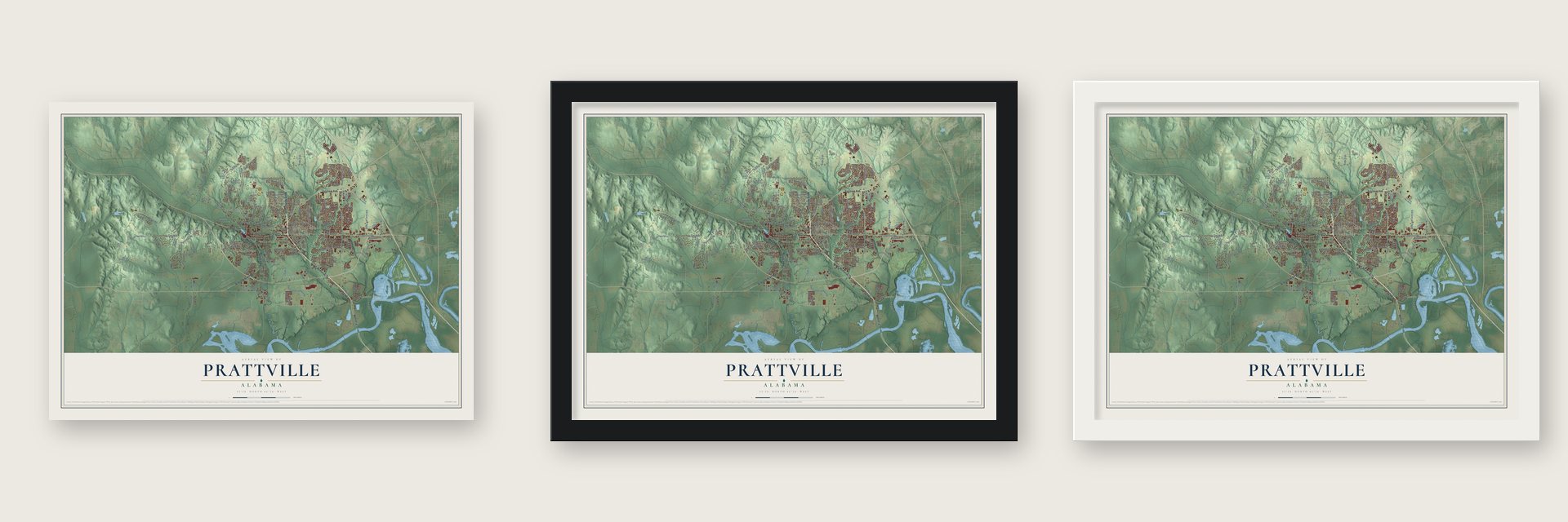
Unframed archival matte, a black wood frame or a white wood frame.
Up close
Geography Worth Displaying
This map was created using accurate cartographic data and authoritative geographic sources, including the U.S. Geological Survey and the Census Bureau. The map brings together terrain, waterways, roads, and building detail. The majority of the streets are labeled, houses are accurately depicted, and the topography is derived from government sources. Combining local data with carefully composed color and shading leads to this beautifully detailed Prattville artwork for your wall.
Rather than simply showing street outlines, we’ve included as many of the street names as we could reasonably fit on the map while keeping their names legible. Zoom in on the high resolution preview to see exactly what’s on the map. We truly set out to create a statement piece for anyone who loves Prattville. So whether it’s for you, or a gift for someone you love, we hope this map of Prattville brings back fond memories.
Read the story behind this map of Prattville, Alabama from 2026.

Find your street
Names on the Prattville map
Every name below is printed on this map. Look for your street, your school, the park where you played, or the pond down the road.
Places and landmarks14
- Dosterville
- Fays
- Hunting Ridge
- Live Oaks
- Melmar
- Overlook
- Pate
- Prattmont
- Scenic Hills
- Upper Kingston
- Willowbrook
- Woodland Heights
Show all 14 places
- Judge
- Senator
Streets and roads187
- South Memorial Drive
- North Memorial Drive
- East Main Street
- Fairview Avenue
- Memorial Drive
- West Fourth Street
- Al Highway 14 West
- Selma Highway
- Cobbs Ford Road
- Tara Drive
- Autauga County 4
- Autauga County 85
- Breakfast Creek Road
- Doster Road
- Upper Kingston Road
- South McQueen Smith Road
- Durden Road
- Indian Hills Road
- Golson Road
- Martin Luther King Drive
- Constitution Avenue
- Washington Ferry Road
- Northington Road
- Sheila Boulevard
- Old Ridge Road North
- Old Ridge Road
- East Sixth Street
- South Industrial Park Road
- Gin Shop Hill Road
- Redfield Road
Show all 187 streets
- Poplar Street
- Jasmine Trail
- Wetumpka Street
- Woodvale Road
- Allenville Road
- Old Farm Lane South
- Tullahoma Drive
- Arrowhead Drive
- Ridgewood Road
- Northington Street
- Summer Lane
- Golson Place Boulevard
- Wright Street
- Gardner Road
- Mimosa Road
- West Sixth Street
- Murfee Drive
- Pierce Lane
- Janice Street
- Heather Drive
- Gillespie Street
- Bass Pro Boulevard
- Joyce Street
- Gray Drive
- Shadow Lane
- First Street
- Wyngate Drive
- Booth Street
- Ridge Trail
- Bridge Street
- Quail Run
- Loder Street
- Sunset Drive
- Till Street
- Inzer Lane
- Bryan Street
- Leigh Drive
- Jay Street
- Patrick Street
- Live Oak
- Lina Drive
- Plum Street
- Dodgers Drive
- Marlette Drive
- Echlin Boulevard
- Lower Kingston Road
- Old Farm Lane North
- North Court Street
- East Poplar Street
- Teri Lane
- Bridge Creek Road
- Calumet Parkway
- Legends Drive
- Silver Hills Drive
- Autauga County 29
- Magnolia Drive
- Greencrest Lane
- Bedford Terrace
- Choctaw Ridge
- Grouby Airport Road
- Mount Airy Drive
- Legends Parkway
- Rolling Hills Drive
- Ashton Oak Drive
- Benson Street
- Sycamore Drive
- Bell Lane
- Jensen Road
- Turner Crs
- Trolley Road
- Covered Bridge Parkway
- Marlyn Drive
- Windrush Lane
- Gaddis Avenue
- Wynoaks Drive
- Shady Hill Road
- Asbury Drive
- East Third Street
- Pebble Creek Drive
- Scenic Drive
- Jordan Crossing
- Pates Mill Lane
- Stanton
- Old Highway 31
- Holly Court
- Mountain Vw
- Tenth Street
- Summit Parkway
- Rambling Brook Lane
- Rice Street
- Graylynn Drive
- Doe Drive
- Oates Road
- Barkley Street
- Stewart Street
- Carver Street
- Vindale Road
- Gaddis Pit Road
- Peagler Street
- Vintage Way
- Dee Drive
- Diane Drive
- Mabel Drive
- Irma Lane
- Ruth Street
- Tr Court
- Chancellor Ridge Road
- Fireside Drive
- Regent Road
- Sweet Ridge Road
- Red Eagle Road
- Lancelot Circle
- Northington Lane
- Pratt Street
- Kingston Oaks Drive
- Fairwood Drive
- Vista Point Boulevard
- Parkview Drive
- Peachtree Street
- Winchester Way
- Heritage Hills Drive
- Abington Street
- Joan Lane
- Cargill Street
- Robbins Drive
- Corley Road
- Fiveash Oak
- Easy Street
- Howard Street
- Windmill Drive
- Valridge West
- Griffith Avenue
- Hargis Drive
- Spruce Street
- Miller Trce
- North McQueen Smith Road
- Edinburgh Street
- Greystone Way
- Perrydale Loop
- Buena Vista Boulevard
- Simmons Road
- Hare Circle
- Scott Lane
- Maple Street
- Home Park Trail
- Charleston Drive
- Overlook Drive
- Coleman Way
- Challenge Avenue
- Guiding Way Lane
- Carter Road
- Emerald Drive
- Linden Lane
- Stakely Drive
- Arbor Lane
- Eds Drive
- Daniel Drive
Names are listed as they appear on the printed map. Zoom into the product photos to find them.
About Prattville, Alabama
Prattville is a city of 37,781 people and the seat of Autauga County, on the banks of Autauga Creek. Daniel Pratt, a native of Temple, New Hampshire, wanted water power for his cotton gin works, so he chose a swampy creekside spot then known as McNeil's or Montgomery's Mill. In 1838 he paid $20,000 for nearly 2,000 acres and built a company town patterned on the mill villages of New England. Amos Smith gave the town its name.
The gin factory grew to as many as 175 workers, who turned out up to 1,500 gins a year for buyers around the world. Pratt added a mill for cotton and woolen cloth, helped start a sash, door and blinds factory, and opened the Prattville Male and Female Academy, where the author Sidney Lanier briefly served as principal. Because the town kept gaining people, wealth and business, the legislature moved the county seat here from Kingston in 1868, and Prattville was incorporated on February 19, 1872.
“Beloved as a place to grow up even in segregated times; black and white children could not go to school together but played together in the branch that runs the length of The Hollow.”
- The Fountain CityFree-flowing artesian wells earned Prattville its nickname. In 1933 the Prattville Progress counted more than 400 of them in and around town, and some fed the town's water system. Many have since been capped, but several public wells still run downtown, and in 2001 the city and the Historic Prattville Redevelopment Authority put up a well house over the much-loved one on Doster Road.
- A plank road to the riverIn the 1840s Pratt built a road more than four miles long, made of big pine logs sawed in half and laid with the round side down. It carried gins from his factory to Washington on the Alabama River, and it cost him between eight and ten thousand dollars.
- Cotton gins until 2012In 1899 the Pratt Gin Company joined several other gin makers to form Continental Gin Company, and in 1986 that firm combined with Murray-Carver to become Continental Eagle Corporation. It kept its headquarters in Prattville and built cotton gins here until 2012. In 2023 a large part of the old factory became loft apartments.
- Buena Vista, circa 1830Capt. William Montgomery, who lived in Pratt's time, completed this Federal-style plantation house. A later Colonial Revival front added a portico with Ionic columns and a cast-iron balcony, and inside, a circular staircase rises 24 feet. As the Montgomery--Janes--Whittaker House, it joined the National Register in 1974.
- Life in Happy HollowSixth Street, once called Fair Road, ran from Northington Street down into Happy Hollow, a traditional African American neighborhood named for a small church known for its lively preaching, singing and shouting. Families drew drinking and washing water from the Spring, an artesian well, before the city had a central water system, and neighbors collected their mail at Miss Molly Burt's home. The Bethlehem church moved to Chestnut and Sixth in 1947.
Keep exploring Alabama
Prattville is one of 675 Alabama towns we've mapped. Every dot on the map is a print of its own.
The search covers every state, Alabama first.
Near Prattville
Order 2 or more town maps and save 10%. Shown in the size and finish you picked above, so they hang as a set.
- Millbrook 12" x 18" / Archival Matte Print $39.99
- Coosada 12" x 18" / Archival Matte Print $39.99
- Catoma 12" x 18" / Archival Matte Print $39.99


More maps nearby: Pine Level, Elmore, Deatsville, Autaugaville and Montgomery.
The art of mapping a place
How This Map Was Made
Real places. Remarkable detail. Discover the layers that turn geographic data into a map of home.

The view from above
Aerial imagery reveals the character of the land: woodland, open fields, and the patterns of a place.

The shape of the land
Elevation data brings hills, valleys, and subtle changes in the landscape into view.

The details of home
Roads, waterways, and building footprints come together to make the map feel unmistakably local.

Geography becomes art
Considered color, shading, and typography bring the layers together in a map made for your wall.


Process illustrated with Mendon, Massachusetts. Aerial imagery: USDA NAIP. Terrain: USGS 3D Elevation Program. Map details and finished artwork: KNOWOL.
The Details
About This Print
Choose an archival matte print, or a black or white Ayous wood frame. The archival matte print is unframed.
Select your size and finish above to see the matching product image and price.
Materials & Craftsmanship
A contemporary map with the character of a classic atlas, printed on archival matte paper. Optional frames are made from Ayous wood.
Your printed map does not include the watermark shown in the full-map preview.
Shipping & Delivery
Free shipping within the United States. Every print is made to order in the USA.
Buying a gift? Add a note in your cart and we'll include it. We never put prices in the package.
Prints ship within 2 to 3 business days. Allow 7 to 10 days total from ordering for delivery. Timing may vary during holidays or periods of high order volume.
Read our shipping policy.
Returns and damaged prints
Each print is made to order. Change-of-mind refunds are not available after production.
If your print arrives damaged, misprinted or incorrect, contact support@knowol.com within 30 days of receiving it. Include your order number, photos and a description of the issue.
Read our full refund and replacement policy. For questions about your order, email support@knowol.com.