
Search for another town


Free U.S. delivery 7 to 10 days after you order
Rutland Town, Vermont Map Art
Building by building, with labeled streets and shaded relief.
12" x 18" Archival Matte Print
A Map of Home. A Work of Art.
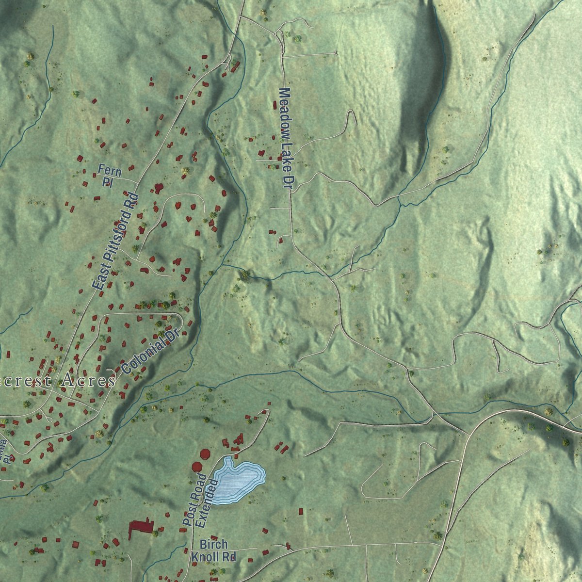
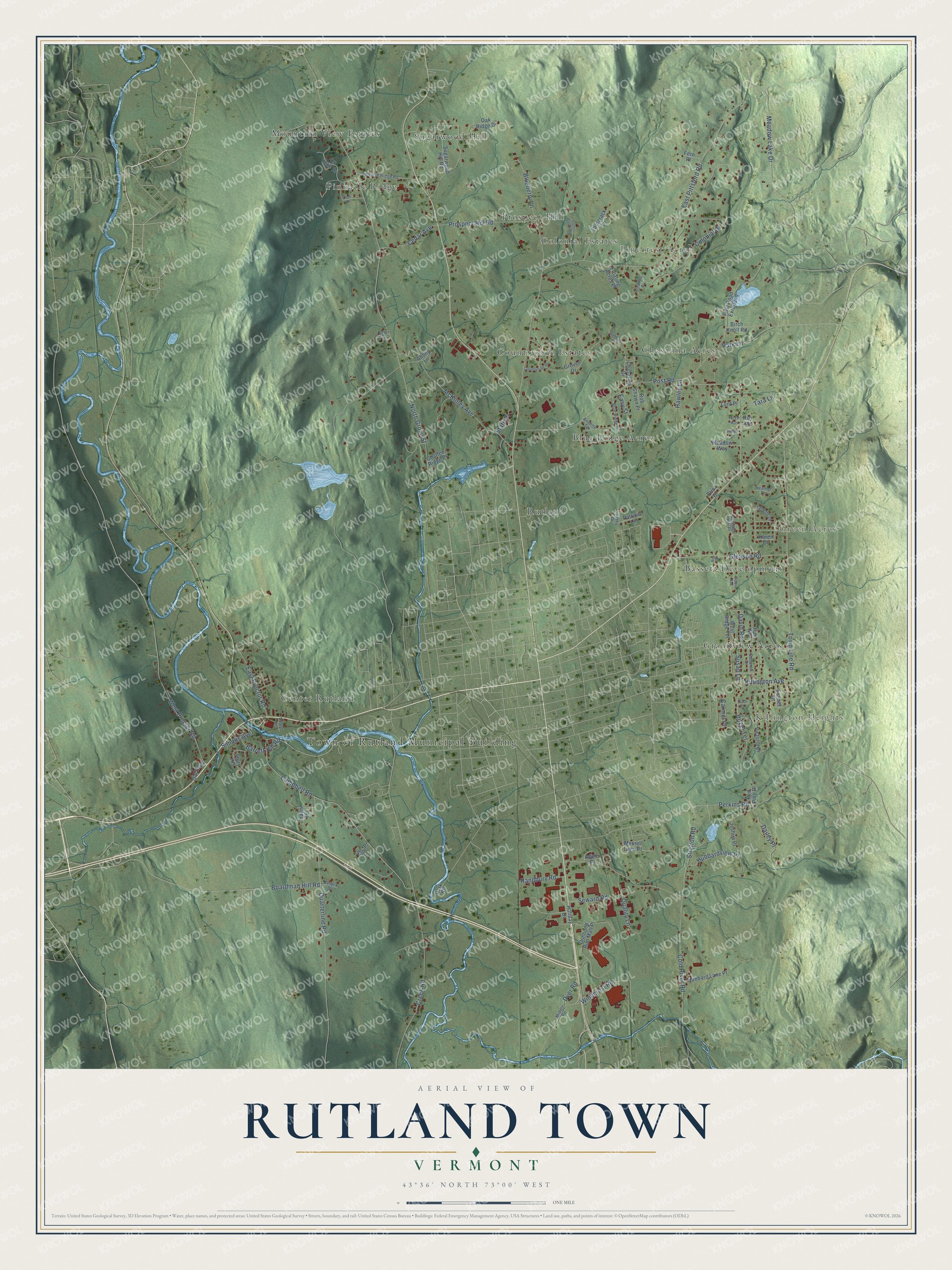
Explore Rutland Town, Vermont from a whole new perspective. Created using aerial imagery and detailed geographic data, this map captures Rutland Town building by building, with labeled streets, familiar landmarks, and shaded topographical relief that highlights the natural contours of the landscape.
Combining modern data with the timeless character of a vintage atlas, this map is just as interesting up close as it is beautiful on the wall. Whether you grew up in Rutland Town, spent memorable years there, or call it home today, this unique map is a great way to celebrate a place that means something to you. Zoom in on the preview to look for your street, and then order a print to put your memories on the wall.
Three ways to hang it

Unframed archival matte, a black wood frame or a white wood frame.
Up close
Geography Worth Displaying
This map was created using accurate cartographic data and authoritative geographic sources, including the U.S. Geological Survey (USGS) and FEMA. The map brings together terrain, waterways, roads, and building detail. The majority of the streets are labeled, houses are accurately depicted, and the topography is derived from government sources. Combining local data with carefully composed color and shading leads to this beautifully detailed Rutland Town artwork for your wall.
Rather than simply showing street outlines, we’ve included as many of the street names as we could reasonably fit on the map while keeping their names legible. Zoom in on the high resolution preview to see exactly what’s on the map. We truly set out to create a statement piece for anyone who loves Rutland Town. So whether it’s for you, or a gift for someone you love, we hope this map of Rutland Town brings back fond memories.
Explore the full map of Rutland Town, Vermont and read about the local places it shows.

Find your street
Names on the Rutland Town map
Every name below is printed on this map. Look for your street, your school, the park where you played, or the pond down the road.
Places and landmarks16
- Town of Rutland Municipal Building
- Green Acres
- Killington Heights
- Pinecrest Acres
- Pinnacle Ridge
- Rutland
- Countryside Estates
- Sugarwood Hill
- Grandview Acres
- Chasanna Acres
- Blue Ridge Acres
- Prospect Hill
Show all 16 places
- Bassett Development
- Mountain View Estates
- Colonial Estates
- Center Rutland
Streets and roads95
- Boardman Hill Road
- North Grove Street
- Campbell Road
- East Pittsford Road
- Post Road
- McKinley Avenue
- Cold River Road
- Quarterline Road
- Colonial Drive
- Prospect Hill Road
- Creek Road
- Town Line Road
- West Proctor Road
- Carmel Place
- Hitzel Terrace
- Windcrest Road
- East Proctor Road
- Perkins Road
- Gleason Road
- Park Lane
- Dailey Place
- Meadow Lake Drive
- Quality Lane
- Stratton Road
- Blueberry Lane
- Killington Avenue
- Cedar Avenue
- Hubbardview Place
- Barrett Hill Road
- Tara Lane
Show all 95 streets
- Simons Avenue
- Randbury Road
- Susan Lane
- Seward Road
- David Road
- Hawley Lane
- Dyer Road
- State Place
- Easy Street
- Ox Yoke Drive
- Sugarwood Hill Road
- Post Road Extended
- Victoria Drive
- Grover Drive
- Chasanna Drive
- Diamond Run Mall Place
- Karen Drive
- West Ridge Terrace
- Sunset Drive
- Tamarack Lane
- Flory Heights
- Joshua Place
- Hubbard Lane Place
- Oak Ridge Drive
- Roy Avenue
- Rob Shawn Place
- Messer Lane Place
- Meadow Way
- Travis Terrace
- Birch Knoll Road
- Holiday Drive
- Patricia Lane
- Floating Acres Place
- Chaffee Ridge Place
- Fern Place
- Ruth Avenue
- Lunt Place
- Red Pine Place
- Sadi Place
- Prior Drive
- Abbey Lane
- Adele Place
- Park Street
- Heritage Hill Place
- Blue Ridge Drive
- Pinnacle Ridge Road
- Annette Terrace
- Lynette Drive
- Kathy Drive
- Middle Road
- Heather Lane
- Deborah Drive
- Amanda Place
- Belock Drive
- Depot Lane
- Lester Lane
- Countryside Drive
- Curtis Brook Road
- Oles Drive
- Elburn Avenue
- Sanborn Place
- Lilac Lane
- Timber Lane
- Forest Way
- Bos Place
Names are listed as they appear on the printed map. Zoom into the product photos to find them.
About Rutland Town, Vermont
Rutland Town is a town of 3,924 people in Rutland County, and it forms a complete ring around Rutland City, a separate municipality. New Hampshire's governor, Benning Wentworth, granted Rutland on September 7, 1761, and named it for John Manners, 3rd Duke of Rutland. Another record credits the name to John Murray, the first proprietor listed, who had come from Rutland. Settlers arrived in 1770, and good farmland on gentle ground made Rutland one of the most successful New Hampshire Grants. The town was also among the capitals of the Vermont Republic.
Marble turned up in Rutland early in the 1800s, and in the 1830s a large deposit of high-quality stone was found in what is now West Rutland. Small firms were working it by the 1840s, but the quarries made no money until the railroad reached Rutland in 1851. Around then the famous quarries of Carrara, Italy, grew too deep to work, so Rutland became one of the world's leading marble producers. In 1886 the marble companies had the center made an incorporated village, and the bulk of the town broke away as West Rutland and Proctor, where most of the quarries lay. The village became Rutland City in 1892, leaving a mostly rural town wrapped around it.
- John Deere's needle trickRutland is John Deere's birthplace. Years later in Illinois, cast-iron plows kept failing in the heavy prairie soil. Deere recalled what the sand had done to the needles, and in 1837 he built the first steel plow to succeed commercially.
- Violins from covered bridgesRussell de Gree Flagg, a violin maker who lived in Rutland, started in 1933 to build instruments from old wood salvaged from local covered bridges. Over the years he made more than 200 violins.
- The Diamond Run Mall, 1995What was once the Diamond Run Mall stands in the south end of Rutland Town. When it opened in 1995, it became the area's second enclosed mall, following the Rutland Mall. The Castleton hockey teams practice nearby at Spartan Arena, which belongs to Castleton University and sits in the same part of town.
Keep exploring Vermont
Rutland Town is one of 333 Vermont towns we've mapped. Every dot on the map is a print of its own.
The search covers every state, Vermont first.
Near Rutland Town
Order 2 or more town maps and save 10%. Shown in the size and finish you picked above, so they hang as a set.
- North Clarendon 12" x 18" / Archival Matte Print $39.99
- Mendon 12" x 18" / Archival Matte Print $39.99
- Proctor 12" x 18" / Archival Matte Print $39.99


More maps nearby: West Rutland, Clarendon, Ira, Pittsford and Shrewsbury.
The art of mapping a place
How This Map Was Made
Real places. Remarkable detail. Discover the layers that turn geographic data into a map of home.

The view from above
Aerial imagery reveals the character of the land: woodland, open fields, and the patterns of a place.

The shape of the land
Elevation data brings hills, valleys, and subtle changes in the landscape into view.

The details of home
Roads, waterways, and building footprints come together to make the map feel unmistakably local.

Geography becomes art
Considered color, shading, and typography bring the layers together in a map made for your wall.


Process illustrated with Mendon, Massachusetts. Aerial imagery: USDA NAIP. Terrain: USGS 3D Elevation Program. Map details and finished artwork: KNOWOL.
The Details
About This Print
Choose an archival matte print, or a black or white Ayous wood frame. The archival matte print is unframed.
Select your size and finish above to see the matching product image and price.
Materials & Craftsmanship
A contemporary map with the character of a classic atlas, printed on archival matte paper. Optional frames are made from Ayous wood.
Your printed map does not include the watermark shown in the full-map preview.
Shipping & Delivery
Free shipping within the United States. Every print is made to order in the USA.
Buying a gift? Add a note in your cart and we'll include it. We never put prices in the package.
Prints ship within 2 to 3 business days. Allow 7 to 10 days total from ordering for delivery. Timing may vary during holidays or periods of high order volume.
Read our shipping policy.
Returns and damaged prints
Each print is made to order. Change-of-mind refunds are not available after production.
If your print arrives damaged, misprinted or incorrect, contact support@knowol.com within 30 days of receiving it. Include your order number, photos and a description of the issue.
Read our full refund and replacement policy. For questions about your order, email support@knowol.com.