


Search for another town


Free U.S. delivery 7 to 10 days after you order
Selma, California Map Art
Building by building, with labeled streets and shaded relief.
12" x 18" Archival Matte Print
A Map of Home. A Work of Art.
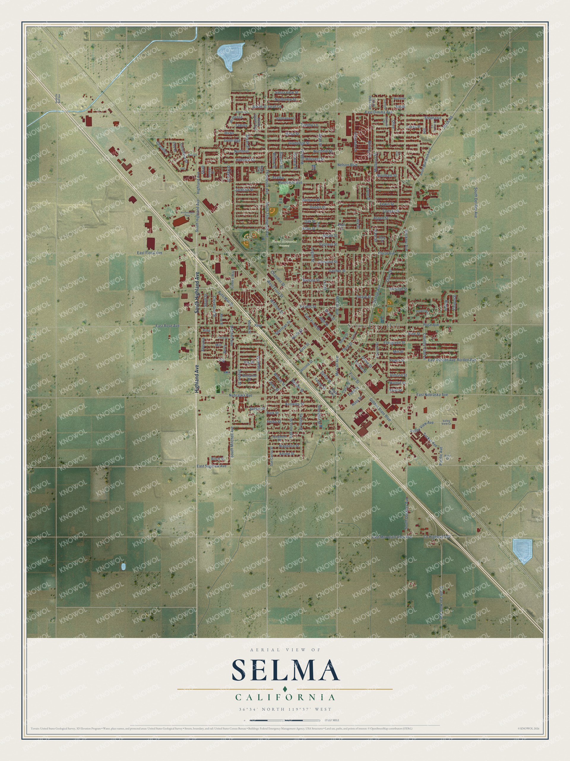
Explore Selma, California from a whole new perspective. Created using aerial imagery and detailed geographic data, this map captures Selma building by building, with labeled streets, familiar landmarks, and shaded topographical relief that highlights the natural contours of the landscape.
Combining modern data with the timeless character of a vintage atlas, this map is just as interesting up close as it is beautiful on the wall. Whether you grew up in Selma, spent memorable years there, or call it home today, this unique map is a great way to celebrate a place that means something to you. Zoom in on the preview to look for your street, and then order a print to put your memories on the wall.
Three ways to hang it

Unframed archival matte, a black wood frame or a white wood frame.
Up close
Geography Worth Displaying
This map was created using accurate cartographic data and authoritative geographic sources, including the U.S. Geological Survey and the Census Bureau. The map brings together terrain, waterways, roads, and building detail. The majority of the streets are labeled, houses are accurately depicted, and the topography is derived from government sources. Combining local data with carefully composed color and shading leads to this beautifully detailed Selma artwork for your wall.
Rather than simply showing street outlines, we’ve included as many of the street names as we could reasonably fit on the map while keeping their names legible. Zoom in on the high resolution preview to see exactly what’s on the map. We truly set out to create a statement piece for anyone who loves Selma. So whether it’s for you, or a gift for someone you love, we hope this map of Selma brings back fond memories.
Read the story behind this map of Selma, California from 2026.

Find your street
Names on the Selma map
Every name below is printed on this map. Look for your street, your school, the park where you played, or the pond down the road.
Places and landmarks2
- Selma City Hall
- Floral Memorial Cemetery
Streets and roads177
- Highland Avenue
- South Highland Avenue
- Thompson Avenue
- Olive Street
- Tammy Lane
- Goldridge Street
- Mulberry Street
- East Rorden Avenue
- Peach Street
- Snyder Street
- Love Street
- Hill
- Columbia Street
- Chaparal
- Whitson Street
- Nebraska Avenue
- Mill Street
- Rorden Avenue
- Wright Street
- Orange Avenue
- Walnut Street
- Ditch Road
- Sierra View Street
- Valley View Avenue
- Sequoia
- Golden State Boulevard
- Dockery Avenue
- McCall Avenue
- South Thompson Avenue
- East Dinuba Avenue
Show all 177 streets
- Floral Avenue
- West Front Street
- Rose Avenue
- Mitchell Avenue
- Nelson Boulevard
- Stillman Street
- South Dockery Avenue
- Barbara Street
- Northhill Street
- Hicks Street
- East Mountain View Avenue
- Aspen Street
- Jasper Street
- East Front Street
- South Van Horn Avenue
- Park Street
- Evergreen Street
- Oak Street
- Gaither Street
- Arrants Street
- Huntsman Avenue
- Sylvia Street
- Country Club Lane
- Pine Street
- Young Street
- Mc Call Avenue
- Lee Street
- East Floral Avenue
- Second Street
- First Street
- Logan Street
- Gaynor Street
- County Highway J40
- Yerba Street
- Pacific Avenue
- Tulare Street
- Jackson Street
- Lewis Street
- North Street
- Alton Street
- Third Street
- Hillcrest Street
- Stephanie
- Northhill
- East Saginaw Avenue
- Burnham Street
- Dennis Drive
- Knowles Street
- East Rose Avenue
- East Street
- Cooper Street
- Bauder Street
- Shaft Street
- Skelton Street
- Willow Street
- Merced Street
- Maple Street
- High Street
- Almond Street
- Chandler Street
- Fig Street
- Claursen Drive
- Grove Street
- Cleveland Street
- Van Horn Street
- Chestnut Street
- Blinkey Drive
- Locust Street
- Tucker Street
- East Nebraska Avenue
- Goldridge
- Wilson Street
- South Mitchell Avenue
- Sheridan Street
- Hillcrest Court
- South Del Rey Avenue
- Magnolia Street
- Northview Street
- Cypress Street
- Allan Street
- Auto Mall Drive
- Adobe Street
- Todd Street
- Sarah Street
- Howard Street
- Ross Street
- Hicks
- Fig
- Tucker Avenue
- Rodeo
- Joy Street
- Olive
- Azalea
- Shaft
- Sherman Street
- Mill
- Berry
- Front Street
- Sarah
- Grant Street
- Chandler
- Sunset Street
- Tammy
- Bryan Street
- Primrose
- O'Ryan Street
- John Street
- Pine
- Birch Street
- Plum Street
- South Mill Ditch Avenue
- Stephanie Lane
- Sycamore Street
- Cinema Way
- Tammy Street
- Selma Street
- South Jasper Avenue
- San Carlos Street
- Nectarine Street
- Mason Street
- South Duke Avenue
- Berry Street
- Sarah Circle
- Canal Street
- Kelly Circle
- Jordan Street
- Clay Court
- Back Alley
- Gary Street
- Alton Court
- Rose
- Garfield
- Northview
- Redwood Lane
- Garfield Street
- Valley View Court
- Birch Court
- Alan
- Dinuba Avenue
- Kent
- Evergreen
- Hillcrest
- Keith Street
- Art Gonzales Parkway
- Via Corvino Street
- South De Wolf Avenue
- Olive Court
Names are listed as they appear on the printed map. Zoom into the product photos to find them.
About Selma, California
Selma is a city of 24,674 people in Fresno County, 16 miles southeast of Fresno. It began as a farm district on the Southern Pacific Railroad, whose line through the Central Valley left a chain of small towns between Sacramento and Bakersfield. Residents formed the Valley View School District in 1880, the same year the first post office opened. Ten years on, the farmers Monroe Snyder, Jacob E. Whitson, George Otis and Egbert H. Tucker went into business together, laid out a townsite by the tracks and sold its lots at auction. When the town was incorporated in March 1893, Selma became Fresno County's second city.
Otis picked the town's name. Railroad employee Sanford Kingsbury had put forward "Selma," for his wife, Selma Michelsen Kingsbury, on a list of possible names his supervisor was drawing up. Otis chose it after talking with other local businessmen. A different story took hold later. In 1925 Selma Gruenberg Lewis said Governor Leland Stanford had seen her picture and ordered the next town on the line named for her. No record backs it up, but her grave marker in Floral Memorial Park still tells it.
- Raisin Capital of the WorldWheat was Selma's first big crop, but peaches, plums and grapes thrived in its sandy soil, watered by Sierra Nevada snowmelt carried in by canal. The town called itself the "Home of the Peach," and a Libby's peach cannery hired many seasonal workers through the 1960s. Raisins became the main crop, though. With the land within eight miles of town growing 90 percent of the nation's raisins, Selma adopted "Raisin Capital of the World" as its slogan in 1963.
- The valley's first pumped wellWilliam De La Grange of Selma grew tired of irrigators pulling Kings River water out of the canal he relied on, so he drilled an open-bottom well. His pumping plant was the first to draw on the San Joaquin Valley's groundwater reservoir. It drew notice, and pumping groundwater soon became common across the valley, with electric motors running the pumps.
- Flour from the Mill DitchIn the late nineteenth century a water-powered mill in town ground wheat into flour. Its power came from the C&K Canal, which carried irrigation water for only part of the year and was known around Selma as the Mill Ditch.
- Inventors, poets and a managerFrank Dusy, Abijah McCall and William Deidrick, who together invented the Fresno scraper, lived in the Selma area. So did the poets William Everson and Larry Levis, Medal of Honor recipient William R. Shockley, historian Victor Davis Hanson and Bobby Cox, manager of the Atlanta Braves.
Keep exploring California
Selma is one of 1,990 California towns we've mapped. Every dot on the map is a print of its own.
The search covers every state, California first.
Near Selma
Order 2 or more town maps and save 10%. Shown in the size and finish you picked above, so they hang as a set.
- Kingsburg 12" x 18" / Archival Matte Print $39.99
- Parlier 12" x 18" / Archival Matte Print $39.99
- Fowler 12" x 18" / Archival Matte Print $39.99

More maps nearby: Del Rey, Monmouth, Bowles, Lone Star and Reedley.
The art of mapping a place
How This Map Was Made
Real places. Remarkable detail. Discover the layers that turn geographic data into a map of home.

The view from above
Aerial imagery reveals the character of the land: woodland, open fields, and the patterns of a place.

The shape of the land
Elevation data brings hills, valleys, and subtle changes in the landscape into view.

The details of home
Roads, waterways, and building footprints come together to make the map feel unmistakably local.

Geography becomes art
Considered color, shading, and typography bring the layers together in a map made for your wall.


Process illustrated with Mendon, Massachusetts. Aerial imagery: USDA NAIP. Terrain: USGS 3D Elevation Program. Map details and finished artwork: KNOWOL.
The Details
About This Print
Choose an archival matte print, or a black or white Ayous wood frame. The archival matte print is unframed.
Select your size and finish above to see the matching product image and price.
Materials & Craftsmanship
A contemporary map with the character of a classic atlas, printed on archival matte paper. Optional frames are made from Ayous wood.
Your printed map does not include the watermark shown in the full-map preview.
Shipping & Delivery
Free shipping within the United States. Every print is made to order in the USA.
Buying a gift? Add a note in your cart and we'll include it. We never put prices in the package.
Prints ship within 2 to 3 business days. Allow 7 to 10 days total from ordering for delivery. Timing may vary during holidays or periods of high order volume.
Read our shipping policy.
Returns and damaged prints
Each print is made to order. Change-of-mind refunds are not available after production.
If your print arrives damaged, misprinted or incorrect, contact support@knowol.com within 30 days of receiving it. Include your order number, photos and a description of the issue.
Read our full refund and replacement policy. For questions about your order, email support@knowol.com.