


Search for another town


Free U.S. delivery 7 to 10 days after you order
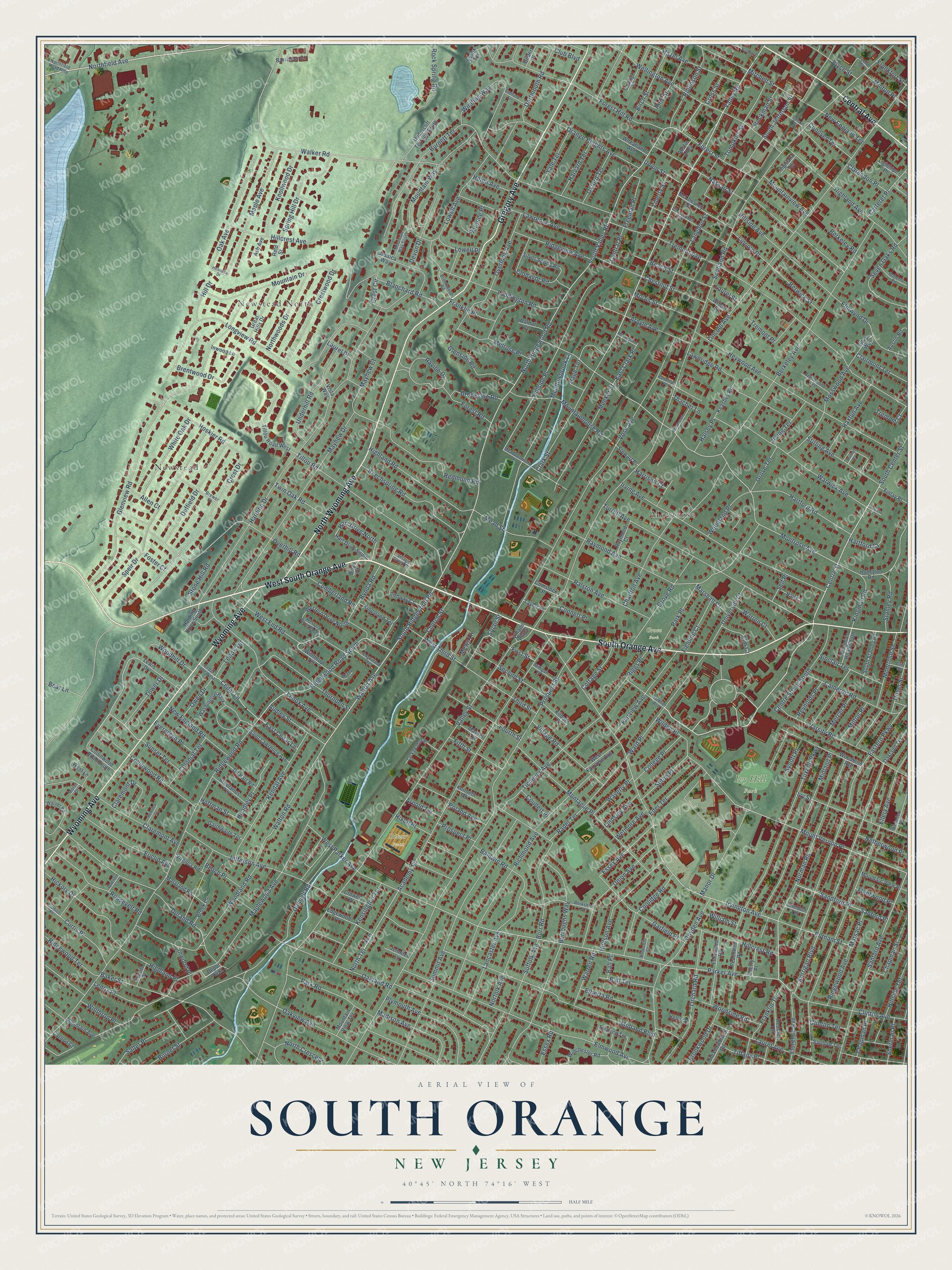
South Orange, New Jersey Map Art
Building by building, with labeled streets and shaded relief.
12" x 18" Archival Matte Print
A Map of Home. A Work of Art.
Explore South Orange, New Jersey from a whole new perspective. Created using aerial imagery and detailed geographic data, this map captures South Orange building by building, with labeled streets, familiar landmarks, and shaded topographical relief that highlights the natural contours of the landscape.
Combining modern data with the timeless character of a vintage atlas, this map is just as interesting up close as it is beautiful on the wall. Whether you grew up in South Orange, spent memorable years there, or call it home today, this unique map is a great way to celebrate a place that means something to you. Zoom in on the preview to look for your street, and then order a print to put your memories on the wall.
Three ways to hang it

Unframed archival matte, a black wood frame or a white wood frame.
Up close
Geography Worth Displaying
This map was created using accurate cartographic data and authoritative geographic sources, including the U.S. Geological Survey and the Census Bureau. The map brings together terrain, waterways, roads, and building detail. The majority of the streets are labeled, houses are accurately depicted, and the topography is derived from government sources. Combining local data with carefully composed color and shading leads to this beautifully detailed South Orange artwork for your wall.
Rather than simply showing street outlines, we’ve included as many of the street names as we could reasonably fit on the map while keeping their names legible. Zoom in on the high resolution preview to see exactly what’s on the map. We truly set out to create a statement piece for anyone who loves South Orange. So whether it’s for you, or a gift for someone you love, we hope this map of South Orange brings back fond memories.
Read the story behind this map: Detailed Map of South Orange, New Jersey.

Find your street
Names on the South Orange map
Every name below is printed on this map. Look for your street, your school, the park where you played, or the pond down the road.
Places and landmarks7
- Ivy Hill Park
- Grove Park
- Ritzer Field
- Newstead North
- Newstead
- Montrose
- Washington Park
Streets and roads420
- West South Orange Avenue
- South Orange Avenue
- North Wyoming Avenue
- Wyoming Avenue
- Gregory Avenue
- Central Avenue
- Valley Street
- Centre Street
- Walton Avenue
- Valley Road
- Crestwood Drive
- South Ridgewood Road
- North Ridgewood Road
- Irvington Avenue
- South Valley Road
- Durand Road
- Florence Avenue
- Mount Vernon Place
- Ridgewood Road South
- Parker Avenue
- Montrose Avenue
- Kerrigan Boulevard
- Hillside Place
- North Terrace
- Essex Avenue
- Hart Drive North
- Scotland Road
- Walker Road
- Prospect Street
- Ridgewood Road
Show all 420 streets
- Maplewood Avenue
- Tremont Avenue
- Harding Drive
- Glenview Road
- Vose Avenue
- Lincoln Avenue
- Crest Drive
- Ellery Avenue
- Highland Avenue
- Academy Street
- Oakland Road
- Berkeley Avenue
- Longview Road
- Summit Avenue
- Eastern Parkway
- Elmwood Avenue
- Dunnell Road
- Richmond Avenue
- Midland Boulevard
- Burnett Terrace
- Heywood Avenue
- Turrell Avenue
- Irving Avenue
- Mayhew Drive
- Fairview Avenue
- Overhill Road
- Northfield Avenue
- South Jefferson Street
- Speir Drive
- Forest Hill Road
- Sanford Avenue
- Redmond Road
- Ward Place
- Tillou Road
- Laurel Avenue
- Meadowbrook Lane
- Grove Road
- Lenox Avenue
- Oakview Avenue
- Boyden Avenue
- Hillside Avenue
- Baker Street
- Tuxedo Parkway
- Charlton Avenue
- Clinton Avenue
- Garfield Place
- Winding Way
- Midland Place
- Norman Road
- Woodland Road
- Maple Avenue
- Jefferson Avenue
- Hillside Terrace
- Luddington Road
- Meeker Street
- Claremont Avenue
- Lowell Avenue
- Blanchard Road
- Warwick Avenue
- Lawrence Avenue
- Varsity Road
- Kendal Avenue
- Franklin Terrace
- Orchard Road
- Mitchell Street
- Clark Street
- West End Road
- Tichenor Avenue
- Mountain Drive
- Beechspring Road
- Melrose Place
- Lawnridge Road
- Union Avenue
- Brookside Road
- Walton Road
- Collinwood Road
- Highland Road
- Beach Street
- Raymond Avenue
- Montrose Street
- Baldwin Road
- Oak Avenue
- Forest Road
- Ralston Avenue
- Ivy Street
- Duffield Drive
- Church Street
- Cameron Road
- Hudson Avenue
- Hartford Road
- Thornden Street
- Hickory Drive
- Plymouth Avenue
- Hillcrest Avenue
- Underhill Road
- Mosswood Avenue
- Wellington Avenue
- Roosevelt Road
- Nassau Street
- Mountainhouse Road
- Spring Hill Drive
- Centre Street South
- Burr Road
- Langdon Street
- Elmwynd Drive
- Montague Place
- Euclid Avenue
- Hoskier Road
- Glenside Road
- Argyle Avenue
- Orange Heights Avenue
- Sandford Place
- Sanford Place
- Coolidge Road
- Hazel Avenue
- Mountain Way
- Park Road
- Manor Drive
- Tremont Place
- Seven Oaks Road
- Village Road
- Franklin Place
- Lenox Place
- Kensington Terrace
- Burroughs Way
- Forest Street
- Rynda Road
- White Oak Drive
- Madison Avenue
- Rollinson Street
- Lancaster Avenue
- Knollwood Drive
- Tompkins Street
- Wilden Place
- Mead Street
- Hillcrest Road
- Third Street
- Chestnut Street
- Sherman Place
- Northwoods Drive
- Curtis Place
- Overlook Avenue
- Waverly Place
- Stirling Avenue
- Fourth Street
- Reynolds Place
- Second Street
- Lincoln Place
- Brentwood Drive
- Ridgeview Avenue
- Riggs Place
- Cedar Lane
- Roland Avenue
- Suffolk Avenue
- New England Road
- Dartmouth Road
- Clonavor Road
- Haxtun Avenue
- Rock Spring Road
- Mews Lane
- University Court
- Page Terrace
- Burnet Street
- Elberta Road
- Putnam Street
- Claremont Drive
- Norfolk Avenue
- Stanley Road
- Birch Street
- Devon Drive
- Park Place
- Salter Place
- Woodside Road
- Pine Street
- Eder Terrace
- Morris Street
- Berwick Street
- North Crescent
- Sinclair Terrace
- Crest Circle
- West Parker Avenue
- Audley Street
- Halsey Place
- Ridgewood Terrace
- Harrison Court
- Beach Place
- Headley Place
- West Third Street
- Highland Place
- College Place
- Brookwood Drive
- Yale Terrace
- Seton Place
- Sloan Street
- Woodland Place
- Ravine Drive
- Fifth Street
- Chapman Street
- Tiffany Place
- Carteret Place
- Harvard Terrace
- Tower Drive
- Joyce Street
- Twin Oak Road
- Foster Court
- Colonial Terrace
- Freeman Place
- Cumberland Road
- Fielding Court
- Warren Road
- Mountainview Avenue
- Dover Street
- Oxford Terrace
- Clairmont Terrace
- Hoffman Street
- Kingman Road
- Ridgewood Avenue
- Warren Court
- Cottage Street
- Ball Terrace
- Irving Terrace
- Conover Terrace
- South Center Street
- Netherwood Place
- Liberty Street
- Woodhill Drive
- Grove Terrace
- First Street
- Owen Drive
- Chapman Place
- New England Terrace
- Evergreen Place
- Sunset Terrace
- Mayhew Court
- Stockman Street
- Clarendon Place
- East Cedar Lane
- Radel Terrace
- Stone Hill Road
- Lowell Place
- Lindsley Avenue
- Winthrop Place
- Milton Place
- East Clark Place
- Mercer Place
- Lenox Terrace
- Union Street
- Marsac Place
- Club Boulevard
- Florence Place
- Hill Drive
- Marshall Court
- Elm Court
- Helen Avenue
- Prospect Place
- Fleetwood Place
- Wetmore Avenue
- Hartford Court
- Tremont Court
- Minton Place
- Hixon Place
- Bear Lane
- Connett Place
- Frankfort Street
- Synott Place
- Central Place
- Arnold Terrace
- Clinton Terrace
- William Street
- Coudert Place
- Allen Court
- Essex Road
- Berkeley Road
- Cross Street
- Thacher Lane
- Laurel Street
- Inwood Place
- Self Place
- Laurel Place
- Ball Place
- Tillou Road West
- Kingman Road South
- Hamilton Road
- Undercliff Terrace South
- Woodbine Avenue
- Jessica Way
- Silver Spring Road
- Peachtree Road
- Fernwood Road
- Headley Terrace
- Kingsland Terrace
- McChesney Street
- Oakland Terrace
- Great Hills Drive
- Mountain Avenue
- Conway Court
- Collinwood Road South
- Western Drive North
- Edgewood Place
- Winchester Road
- Saint Lawrence Avenue
- Lewis Drive
- Mountain View Place
- Fleming Terrace
- Stewart Place
- South Stanley Road
- Hart Drive South
- Barringer Court
- Winthrop Terrace
- Carlton Court
- West Fairview Avenue
- Arcularius Terrace
- De Hart Road
- Sylvan Way
- Garthwaite Terrace
- Meadowbrook Road
- Raymond Court
- Mountain View Terrace
- Virginia Road
- Keasbey Road
- Wheatland Avenue
- Maryland Road
- Kilburn Place
- Sanford Terrace
- Finlay Place
- West Lane
- Harding Drive South
- Brook Lane
- Crowell Place
- Massel Terrace
- Austin Road
- Depot Plaza
- Walnut Court
- Cherry Place
- Inwood Lane
- Willow Street
- Comstock Place
- Lighthipe Place
- Jennifer Lane
- Essex Terrace
- Hall Court
- Everitt Place
- Kenneth Terrace
- Gilbert Place
- Taylor Place
- Highland Terrace
- Sheldon Terrace
- Ash Avenue
- Heller Place
- Reid Street
- Village Plaza
- Austin Alley
- Vista Way
- Briar Court
- Village Green Court
- Curtiss Place
- Cedar Lane West
- Berkshire Road
- Meadowbrook Place
- Christopher Street
- Oakridge Road
- Lackawanna Place
- Gardner Avenue
- Brewer Court
- Richelieu Terrace
- Warner Road
- Roberts Road
- Brookwood Road
- Beechwood Terrace
- Mountain Way South
- Edgewood Terrace
- Western Drive South
- Milligan Place
- Northfield Road Rmp
- Briarcliff Court
- Randolph Place
- Cliff Street
- Quentin Court
- Codner Street
- Morse Drive
- Henrietta Drive
- Henderson Drive
- Wesley Court
- Nutman Place
- Sheffield Terrace
- Stetson Street
- Hemlock Court
- McLaughlin Place
- Patricia Court
- Stirling Drive
Names are listed as they appear on the printed map. Zoom into the product photos to find them.
About South Orange, New Jersey
South Orange was once known as the Chestnut Hills. A deed from 1800 called the place South Orange, and the older name faded away. The name Orange honored William of Orange, ruler of England. After the Civil War, the village became a peaceful escape from busy city life.
Keep exploring New Jersey
South Orange is one of 990 New Jersey towns we've mapped. Every dot on the map is a print of its own.
The search covers every state, New Jersey first.
Near South Orange
Order 2 or more town maps and save 10%. Shown in the size and finish you picked above, so they hang as a set.
- South Orange Village 12" x 18" / Archival Matte Print $39.99
- Montrose 12" x 18" / Archival Matte Print $39.99
- Maplewood 12" x 18" / Archival Matte Print $39.99


More maps nearby: Gregory, Orange, Irvington, Vauxhall and West Orange.
The art of mapping a place
How This Map Was Made
Real places. Remarkable detail. Discover the layers that turn geographic data into a map of home.

The view from above
Aerial imagery reveals the character of the land: woodland, open fields, and the patterns of a place.

The shape of the land
Elevation data brings hills, valleys, and subtle changes in the landscape into view.

The details of home
Roads, waterways, and building footprints come together to make the map feel unmistakably local.

Geography becomes art
Considered color, shading, and typography bring the layers together in a map made for your wall.


Process illustrated with Mendon, Massachusetts. Aerial imagery: USDA NAIP. Terrain: USGS 3D Elevation Program. Map details and finished artwork: KNOWOL.
The Details
About This Print
Choose an archival matte print, or a black or white Ayous wood frame. The archival matte print is unframed.
Select your size and finish above to see the matching product image and price.
Materials & Craftsmanship
A contemporary map with the character of a classic atlas, printed on archival matte paper. Optional frames are made from Ayous wood.
Your printed map does not include the watermark shown in the full-map preview.
Shipping & Delivery
Free shipping within the United States. Every print is made to order in the USA.
Buying a gift? Add a note in your cart and we'll include it. We never put prices in the package.
Prints ship within 2 to 3 business days. Allow 7 to 10 days total from ordering for delivery. Timing may vary during holidays or periods of high order volume.
Read our shipping policy.
Returns and damaged prints
Each print is made to order. Change-of-mind refunds are not available after production.
If your print arrives damaged, misprinted or incorrect, contact support@knowol.com within 30 days of receiving it. Include your order number, photos and a description of the issue.
Read our full refund and replacement policy. For questions about your order, email support@knowol.com.