


Search for another town


Free U.S. delivery 7 to 10 days after you order
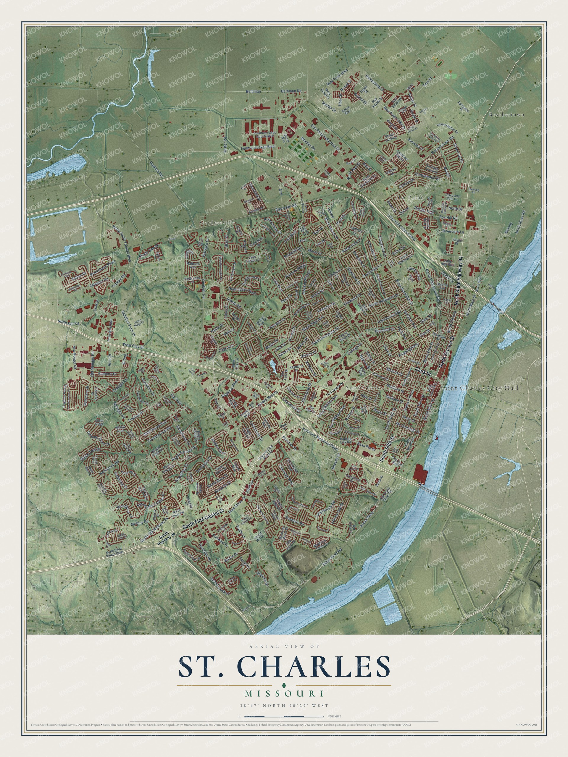
St. Charles, Missouri Map Art
Building by building, with labeled streets and shaded relief.
12" x 18" Archival Matte Print
A Map of Home. A Work of Art.
Explore St. Charles, Missouri from a whole new perspective. Created using aerial imagery and detailed geographic data, this map captures St. Charles building by building, with labeled streets, familiar landmarks, and shaded topographical relief that highlights the natural contours of the landscape.
Combining modern data with the timeless character of a vintage atlas, this map is just as interesting up close as it is beautiful on the wall. Whether you grew up in St. Charles, spent memorable years there, or call it home today, this unique map is a great way to celebrate a place that means something to you. Zoom in on the preview to look for your street, and then order a print to put your memories on the wall.
Three ways to hang it

Unframed archival matte, a black wood frame or a white wood frame.
Up close
Geography Worth Displaying
This map was created using accurate cartographic data and authoritative geographic sources, including the U.S. Geological Survey and the Census Bureau. The map brings together terrain, waterways, roads, and building detail. The majority of the streets are labeled, houses are accurately depicted, and the topography is derived from government sources. Combining local data with carefully composed color and shading leads to this beautifully detailed St. Charles artwork for your wall.
Rather than simply showing street outlines, we’ve included as many of the street names as we could reasonably fit on the map while keeping their names legible. Zoom in on the high resolution preview to see exactly what’s on the map. We truly set out to create a statement piece for anyone who loves St. Charles. So whether it’s for you, or a gift for someone you love, we hope this map of St. Charles brings back fond memories.
Read the story behind this map of St. Charles, Missouri from 2026.

Find your street
Names on the St. Charles map
Every name below is printed on this map. Look for your street, your school, the park where you played, or the pond down the road.
Places and landmarks5
- Saint Charles City Hall
- Gardnerville
- Saint Charles
- Boschertown
- Elm Point
Streets and roads377
- South First Capitol Drive
- North Second Street
- Clark Street
- South Fifth Street
- North State Highway 94
- West Clay Street
- South Old Highway 94
- Truman Road
- South Main Street
- North Main Street
- Saint Charles Avenue
- Arena Parkway
- Old Muegge Road
- South River Road
- Friedens Road
- Zumbehl Road
- Banbury Drive
- North Third Street
- Ehlmann Road
- Hayford Road
- Graystone Drive
- North Fifth Street
- Little Hills Expressway
- Spring Mill Estates Drive
- South Duchesne Drive
- South Pam Avenue
- Kingshighway
- Veterans Memorial Parkway
- Elm Street
- West Adams Street
Show all 377 streets
- Muegge Road
- Elm Point Road
- Droste Road
- Elm Point Industrial Drive
- Huster Road
- Boschertown Road
- New Town Boulevard
- West Randolph Street
- Park Avenue
- Hackmann Road
- Country Club Road
- Hemsath Road
- Mueller Road
- North Duchesne Drive
- Fox Hill Road
- Yale Boulevard
- Bethman
- Bethman Road
- Sibley Street
- North River Road
- Perry Street
- Talbridge Way
- Norwich Drive
- Headland Drive
- Jackson Street
- Hawks Nest Drive
- Fairgrounds Road
- Madison Street
- Concordia Lane
- Gallaher Avenue
- Blue Stone Drive
- McClay Road
- Monroe Street
- Mayer Drive
- Hempstead Street
- Rebecca Drive
- South Sixth Street
- Olive Street
- Cottonwood Drive
- Hawthorne Avenue
- Harry South Truman Boulevard
- Elmwood Drive
- Pike Street
- Autumn Wood Drive
- Cole Boulevard
- Mc Donough Street
- Pralle Lane
- Sandfort Farm Drive
- Bogey Estates Drive
- Runnymede Drive
- Fountain Lakes Boulevard
- Mockingbird Drive
- Indian Hills Drive
- North Fifth Street Extension
- Wild Goose Run
- Kunze Drive
- Hunters Ridge
- Apricot Drive
- Tarn Street
- Charwood Street
- Ridgeview Drive
- Huntington Parkway
- Deergrass Drive
- Cunningham Avenue
- Barter Street
- Lynnbrook Drive
- Water Street
- Ruth Drive
- Ken Drive
- Santa Fe Street
- Broad Street
- Silvertrail Drive
- Kettering Court
- Shady Oak Drive
- Scenic Cove Lane
- New Town Lake Drive
- Hawk Drive
- Kandahar Drive
- Glenco Drive
- Blanche Drive
- South Third Street
- Maple Tree Drive
- Portwest Drive
- Vine Street
- Arpent Street
- Boschert Drive
- Abbydale Drive
- Riverchase Parkway
- Deerfield Drive
- North Drive
- Willow Oak Drive
- Riverview Lane
- Santa Rosa Street
- Ford Lane
- Chargene Street
- Cherokee Lane
- Suntan Drive
- Woodbriar Lane
- Regency Parkway
- Bass Pro Drive
- Lee Drive
- Nathan Street
- Warwick Drive
- Berlekamp Drive
- Hineman Drive
- Walters Way
- Treetop Drive
- Norma Drive
- Chemin Avenue
- Arco Drive
- Mango
- Cutright Lane
- Depot Lane
- Spring
- Oriole Drive
- North Rue Street
- Tiber Street
- North Svc Road
- Devilla Trail
- Sherman Drive
- Hiram Street
- Elm
- Beverly Drive
- Blair Place
- Briarcliff Drive
- Elk Trail
- Marie Drive
- Sutton Drive
- Watson Street
- Faye Avenue
- Picardy
- Paula Drive
- Dove Drive
- College Drive
- Anneric Street
- James Drive
- Judy Drive
- Nancy Drive
- Robin Drive
- Hilltop
- Quince
- Melody
- Rue Street
- Ken
- South Highway 94
- New Muegge Road
- Wright Drive
- Sun Lake Drive
- Lake Court
- Lakeshore Drive
- Park Court
- Lancaster Drive
- Rivers Edge Drive
- Bogey Estate Drive
- Old South River Road
- Cattail Way
- Boones Lick Road
- Jefferson Street
- Westminster Drive
- Clarendon Lane
- South Second Street
- Cypress Drive
- North Sixth Street
- North Outer Road
- Brighton Park Drive
- Carriage Crossing
- Shorewinds Trail
- Thrush Drive
- Elmhurst Drive
- Bentwater Place
- Hawks Nest
- Island Harbor Drive
- Summitview Drive
- Eagle Forest Drive
- Canary Lane
- Point West Boulevard
- McNair Park Drive
- Forest Avenue
- Ameristar Boulevard
- Country Club Plaza Drive
- Kettering Drive
- Falcons Way
- Olde Court Road
- Montclair Tower Drive
- Westborough Drive
- Double Eagle Drive
- Spring Mill Creek
- Cambrian Way
- Lake Forest Lane
- Quail Run Lane
- Country Bluff Drive
- Lewis Street
- Blanchette Drive
- Willow Trail
- Little Hills Boulevard
- Prairie Haute Drive
- Greenleaf Drive
- La Brea Drive
- Fountain Lakes Industrial Drive
- Calhoun Drive
- Galt House Drive
- Randolph Street
- North Main
- Rio Vista Drive
- South Wheaton Drive
- North Overbrook Drive
- Discovery Path Lane
- Rue Royale Street
- Montclair Manor Drive
- Canal Street
- Charann Street
- North Saint Peters Parkway
- Nantucket Drive
- Barthel Avenue
- Silver Ridge
- Tilbury Drive
- Stowe Landing
- Penbrooke Lane
- Landau Court
- Forest Hills Drive
- San Juan Drive
- Marbach Way
- Lost Meadow
- Christy Drive
- Sussex Drive
- Saint Robert Lane
- North Village Drive
- Elmcrest Drive
- Linden Place
- Raymond Drive
- Cogwheel Station
- Arcadia Drive
- Cheshire Drive
- Empire Drive
- Dyess Way
- Santa Maria Street
- Eagle Cove Lane
- White Oaks Lane
- Glazer Way
- Lightfoot Drive
- Kingdom Drive
- Sassafras Court
- Diekamp Lane
- Butler Way
- Palisades Drive
- West Canal Street
- Signal Hill Court
- Frank Drive
- Park Drive
- Sue Lane
- Shire Lane
- Beale Street
- Bel Rae Court
- Sylvan Lane
- Santa Clara Street
- Forest Hill Drive
- Dahlia Court
- Lee Court
- Wainwright Street
- Granger Boulevard
- North Fourth Street
- Diekamp Farm Trail
- Oakleaf Drive
- Pinedale Drive
- Honey Locust Lane
- Woodlawn Drive
- Transit Street
- Exchange Drive
- Oak Avenue
- Hughes Lane
- Florine Boulevard
- Fountainview Drive
- Boone Avenue
- Bridle Spur Lane
- Collingwood Drive
- Gardenbridge Place
- Banon Drive
- Ithaca Circle
- White Lake Drive
- Dardenne Street
- Wall Street
- Seven Oaks Drive
- Prescott Ridge
- Ruger Circle
- Esterling Drive
- Bismark Drive
- Depaula Trail
- Hawning Road
- Antler Ridge Drive
- Birch Tree Drive
- Charles Drive
- Walsh Court
- Santa Ynez Drive
- Wolverton Court
- Marr Lane
- Plaza Way
- Seton Court
- Pallardy Lane
- Par Drive
- Carr Street
- Clover Lane
- Biloxi Court
- Allen Avenue
- Ivy Court
- First Capitol Drive
- Simeon Bunker Street
- Shadow Wood Drive
- Scarsdale Manor Drive
- Time Centre Drive
- Covington Parkway
- Hastings Way
- Towerbridge Place
- Timberidge Drive
- Burning Tree Lane
- Plaza Court
- Sturbridge Drive
- Tuscany Trace Drive
- Greendale Drive
- Michaelwood Court
- Pierpoint Lane
- Avignon Drive
- Sweetwater Crossing Place
- Westbury Drive
- Mercantile Industrial Drive
- Longbow Trail
- Lake Forest Drive
- Chester Boulevard
- Kristopher Bend
- Howell Street
- Olde Worcester Drive
- John Weber Drive
- Sublette Street
- Chestnut Drive
- Buckingham Place
- Angelique Place
- Town West Drive
- Berwick Court
- Exist Old Elm Street
- Dexter Drive
- Fairways Circle
- Hanover Hills Court
- Ehlman
- Mulberry Lane
- Huck Finn Drive
- San Jose Drive
- Teduke Court
- Walnut Street
Names are listed as they appear on the printed map. Zoom into the product photos to find them.
About St. Charles, Missouri
St. Charles is the seat of St. Charles County, with 70,493 residents recorded in the 2020 census. Founded around 1769, the city developed beside the Missouri River and served as Missouri's temporary capital from 1821 through 1826. Historic Main Street and the riverfront remain a center for community life and commerce.
- French BeginningsFrench Canadian fur trader Louis Blanchette founded the settlement, then called Les Petites Cotes, around 1769.
- Expedition StopIn May 1804, the Lewis and Clark Expedition completed final preparations in St. Charles before continuing upriver.
- First State CapitalMissouri's government met in St. Charles from 1821 until 1826 while Jefferson City was being developed.
- Historic Main StreetThe St. Charles Historic District covers three North Main Street blocks numbered 100 through 300.
- River Port LegacyDuring the 18th and 19th centuries, the waterfront supported westward commerce and expansion, including trade with tribes along the upper Missouri River.
Keep exploring Missouri
St. Charles is one of 1,207 Missouri towns we've mapped. Every dot on the map is a print of its own.
The search covers every state, Missouri first.
Near St. Charles
Order 2 or more town maps and save 10%. Shown in the size and finish you picked above, so they hang as a set.
- Champ 12" x 18" / Archival Matte Print $39.99
- St. Peters 12" x 18" / Archival Matte Print $39.99
- Bridgeton 12" x 18" / Archival Matte Print $39.99


More maps nearby: Maryland Heights, Howell, Hazelwood, Orchard Farm and Cottleville.
The art of mapping a place
How This Map Was Made
Real places. Remarkable detail. Discover the layers that turn geographic data into a map of home.

The view from above
Aerial imagery reveals the character of the land: woodland, open fields, and the patterns of a place.

The shape of the land
Elevation data brings hills, valleys, and subtle changes in the landscape into view.

The details of home
Roads, waterways, and building footprints come together to make the map feel unmistakably local.

Geography becomes art
Considered color, shading, and typography bring the layers together in a map made for your wall.


Process illustrated with Mendon, Massachusetts. Aerial imagery: USDA NAIP. Terrain: USGS 3D Elevation Program. Map details and finished artwork: KNOWOL.
The Details
About This Print
Choose an archival matte print, or a black or white Ayous wood frame. The archival matte print is unframed.
Select your size and finish above to see the matching product image and price.
Materials & Craftsmanship
A contemporary map with the character of a classic atlas, printed on archival matte paper. Optional frames are made from Ayous wood.
Your printed map does not include the watermark shown in the full-map preview.
Shipping & Delivery
Free shipping within the United States. Every print is made to order in the USA.
Buying a gift? Add a note in your cart and we'll include it. We never put prices in the package.
Prints ship within 2 to 3 business days. Allow 7 to 10 days total from ordering for delivery. Timing may vary during holidays or periods of high order volume.
Read our shipping policy.
Returns and damaged prints
Each print is made to order. Change-of-mind refunds are not available after production.
If your print arrives damaged, misprinted or incorrect, contact support@knowol.com within 30 days of receiving it. Include your order number, photos and a description of the issue.
Read our full refund and replacement policy. For questions about your order, email support@knowol.com.