
Search for another town


Free U.S. delivery 7 to 10 days after you order
St. Petersburg, Florida Map Art
Building by building, with labeled streets and shaded relief.
12" x 18" Archival Matte Print
A Map of Home. A Work of Art.
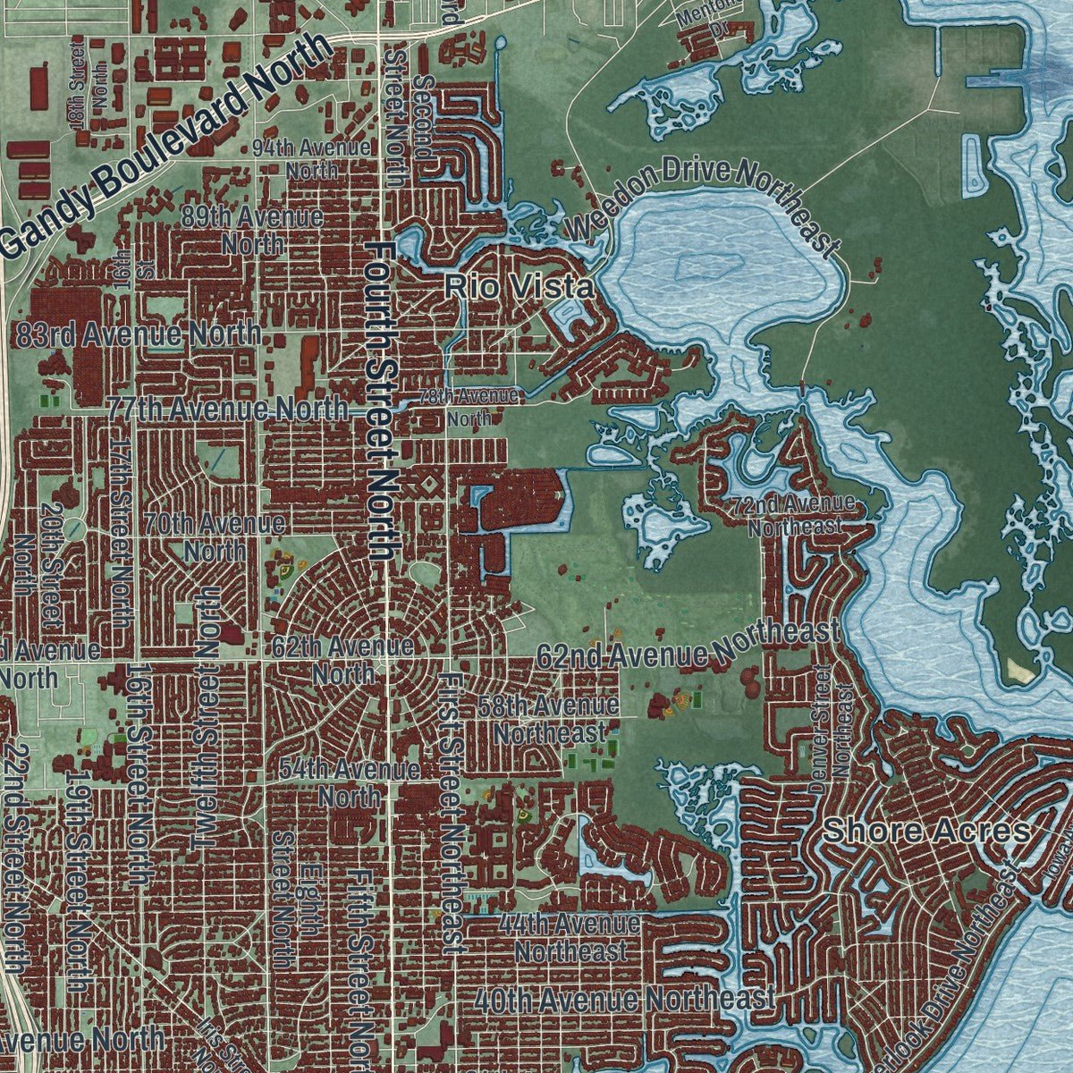
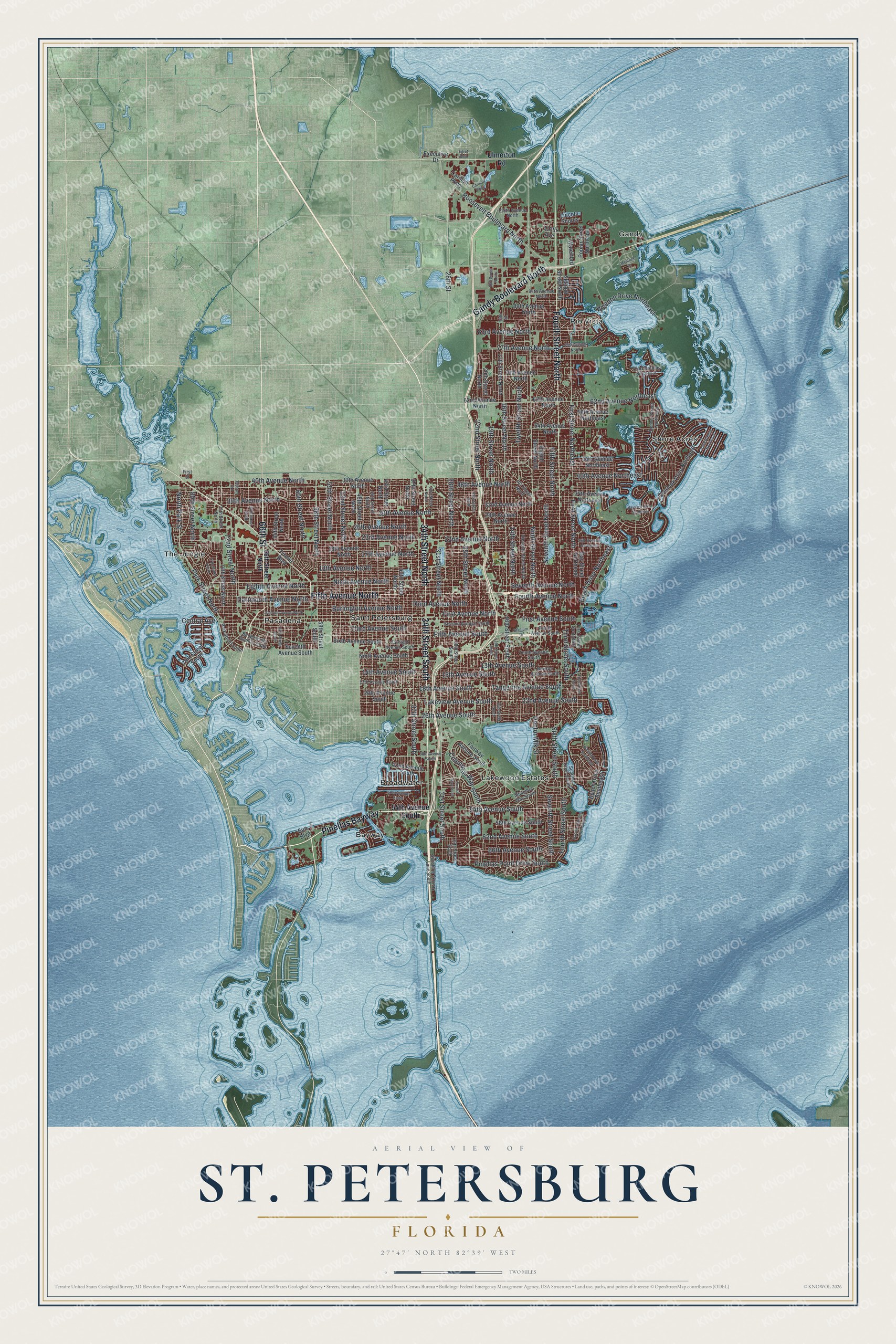
Explore St. Petersburg, Florida from a whole new perspective. Created using aerial imagery and detailed geographic data, this map captures St. Petersburg building by building, with labeled streets, familiar landmarks, and shaded topographical relief that highlights the natural contours of the landscape.
Combining modern data with the timeless character of a vintage atlas, this map is just as interesting up close as it is beautiful on the wall. Whether you grew up in St. Petersburg, spent memorable years there, or call it home today, this unique map is a great way to celebrate a place that means something to you. Zoom in on the preview to look for your street, and then order a print to put your memories on the wall.
Three ways to hang it

Unframed archival matte, a black wood frame or a white wood frame.
Up close
Geography Worth Displaying
This map was created using accurate cartographic data and authoritative geographic sources, including the U.S. Geological Survey (USGS) and FEMA. The map brings together terrain, waterways, roads, and building detail. The majority of the streets are labeled, houses are accurately depicted, and the topography is derived from government sources. Combining local data with carefully composed color and shading leads to this beautifully detailed St. Petersburg artwork for your wall.
Rather than simply showing street outlines, we’ve included as many of the street names as we could reasonably fit on the map while keeping their names legible. Zoom in on the high resolution preview to see exactly what’s on the map. We truly set out to create a statement piece for anyone who loves St. Petersburg. So whether it’s for you, or a gift for someone you love, we hope this map of St. Petersburg brings back fond memories.
Explore the full map of St. Petersburg, Florida and read about the local places it shows.

Find your street
Names on the St. Petersburg map
Every name below is printed on this map. Look for your street, your school, the park where you played, or the pond down the road.
Places and landmarks9
- Bayway
- Broadwater
- Gandy
- Lakewood Estates
- Pasadena
- Rio Vista
- Saint Petersburg
- Shore Acres
- The Jungle
Streets and roads170
- Pinellas Bayway
- 66th Street
- Fourth Street North
- Gandy Boulevard North
- Fifth Avenue North
- 34th Street South
- 34th Street North
- Third Avenue South
- Fifth Avenue South
- First Street North
- First Street Northeast
- Columbus Way South
- Ninth Street North
- 22nd Avenue North
- Central Avenue
- 16th Street North
- 38th Avenue North
- 30th Avenue North
- 34th Avenue North
- First Avenue South
- Ninth Avenue North
- 26th Avenue North
- First Avenue North
- 13th Avenue North
- Fourth Avenue North
- 40th Avenue North
- Seventh Avenue North
- Burlington Avenue North
- Third Avenue North
- 17th Avenue North
Show all 170 streets
- Dartmouth Avenue North
- 28th Street North
- Eighth Avenue North
- Fifth Street North
- Lakeview Avenue South
- Twelfth Street North
- 31st Street South
- Seventh Street North
- 23rd Avenue North
- 14th Street North
- 22nd Avenue South
- 18th Avenue South
- Fourth Street South
- 15th Avenue South
- 13th Avenue South
- Tangerine Avenue South
- Seventh Street South
- 22nd Street North
- 14th Avenue South
- 37th Street South
- Sixth Street South
- 26th Avenue South
- 62nd Avenue South
- 19th Street North
- 28th Street
- North Park Street
- Park Street North
- 77th Avenue North
- Pinellas Point Drive South
- 58th Street North
- 54th Avenue South
- 52nd Street North
- 72nd Street North
- 55th Street North
- 25th Street North
- 66th Avenue South
- 31st Street North
- Roosevelt Boulevard North
- Third Street South
- Weedon Drive Northeast
- 60th Street North
- 83rd Avenue North
- 62nd Avenue Northeast
- 40th Avenue Northeast
- Beach Drive Northeast
- 80th Street North
- Doctor Mlk Street
- Ulmerton Road
- 20th Street North
- Fairway Avenue South
- Seventh Avenue South
- 89th Avenue North
- 32nd Avenue North
- 28th Avenue North
- Eighth Street North
- 39th Avenue North
- 18th Avenue North
- Sixth Avenue South
- 17th Street North
- Ninth Avenue South
- Second Street North
- 16th Street South
- 20th Avenue South
- 49th Street North
- Bay Street Northeast
- 43rd Street North
- 40th Street North
- 37th Street North
- 58th Avenue South
- Beach Drive Southeast
- 62nd Avenue North
- 62th Avenue North
- 54th Avenue North
- 74th Street North
- 64th Street North
- Poplar Street Northeast
- Overlook Drive Northeast
- 79th Street South
- Carillon Parkway
- 42nd Avenue South
- 70th Avenue North
- 44th Avenue Northeast
- Waterford
- 112th Avenue
- 58th Avenue Northeast
- 34th Avenue Northeast
- 58th Street South
- Executive Drive
- Lincoln Shores
- Tyrone Boulevard
- Sun Boulevard
- 66th Street North
- Second Avenue South
- Fourth Avenue South
- 17th Avenue South
- 28th Street South
- Eleventh Street North
- Fairfield Avenue South
- Tenth Avenue South
- 46th Street North
- 29th Street South
- First Street Southeast
- 75th Street North
- 94th Avenue North
- 118th Avenue North
- Sunrise Drive South
- Iris Street North
- Newton Avenue South
- Sunshine Skyway Lane South
- Alhambra Way South
- Bougainvilla Avenue South
- Park Street South
- 72nd Avenue Northeast
- Denver Street Northeast
- First Street
- 16th Street
- 24th Street North
- 78th Avenue North
- Bayview Drive Northeast
- 19th Street South
- 20th Avenue Northeast
- Second Avenue North
- 18th Street North
- 18th Street South
- 68th Street North
- 50th Avenue South
- 38th Avenue South
- Cortez Way South
- 33rd Street North
- First Street South
- Bahama Shores Drive South
- Belcher Road
- Whiting Drive Southeast
- 64th Street South
- Egret Boulevard
- Iowa Avenue Northeast
- Carillon Pwky
- Stadium Drive
- 77th Street North
- Mentone Drive
Names are listed as they appear on the printed map. Zoom into the product photos to find them.
About St. Petersburg, Florida
St. Petersburg is a city of 258,308 people in Pinellas County, on the peninsula that separates Tampa Bay from the Gulf of Mexico. John C. Williams of Detroit bought the land in 1875, and in 1888 Peter Demens extended the Orange Belt Railway to its terminus here. Local lore says the two founders tossed a coin to decide who would name the place. Demens won and named the town for the Russian city of Saint Petersburg, his home for half of his youth, so Williams gave the first hotel, the Detroit, the name of his own birthplace.
The town was incorporated on February 29, 1892, with 300 people, and it became a city in June 1903. Dredging from 1906 to 1908 cut a deeper shipping channel for larger ships, and by the 1910s the population had grown to 4,127. In the 1920s as many as a quarter million visitors a year came by car, yacht and train from Canada, the North and the Midwest.
- An airline across the bayOn January 1, 1914, pilot Tony Jannus took off from St. Petersburg in a Benoist airboat and landed in Tampa about 23 minutes later. That trip launched the St. Petersburg-Tampa Airboat Line, counted as the nation's first scheduled airline flying a fixed-wing plane. Former mayor Abram C. Pheil rode as its first passenger after winning the seat at auction for $400.
- Fish off the railroad pierIn 1899 Henry W. Hibbs, a native of Newport, North Carolina, opened a wholesale fish business at the far end of the railroad pier, which reached out to the shipping channel. It grew into St. Petersburg's first big industry, and inside of a year Hibbs Fish Company was sending out more than 1,000 pounds of fish every day.
- Spring training since 1914Al Lang persuaded the St. Louis Browns to hold spring training here in 1914, then kept drawing teams and their fans until, by the 1920s, the area had become the home base of the Grapefruit League. Lang later served as mayor. On March 31, 1998, Tropicana Field hosted the first game of the Tampa Bay Devil Rays, giving the region its first professional baseball team.
- Swim-ins, 1955 to 1959For five years, Black residents held swim-ins to protest segregation at the city's beaches and pools. In 1957 a court ruled in Alsup v. St. Petersburg that the city could not keep them segregated, and in 1959 the beaches and pools opened again to everyone.
- 768 sunny days in a rowSt. Petersburg averages 361 days of sunshine a year, and between 1967 and 1969 it logged 768 sunny days without a break, a Guinness World Record. That weather earned it the nickname the Sunshine City and made it a favorite place to retire.
Keep exploring Florida
St. Petersburg is one of 1,067 Florida towns we've mapped. Every dot on the map is a print of its own.
The search covers every state, Florida first.
Near St. Petersburg
Order 2 or more town maps and save 10%. Shown in the size and finish you picked above, so they hang as a set.
- Gulfport 12" x 18" / Archival Matte Print $39.99
- Lealman 12" x 18" / Archival Matte Print $39.99
- Bear Creek 12" x 18" / Archival Matte Print $39.99


More maps nearby: Kenneth City, South Pasadena, St. Pete Beach, West Lealman and Treasure Island.
The art of mapping a place
How This Map Was Made
Real places. Remarkable detail. Discover the layers that turn geographic data into a map of home.

The view from above
Aerial imagery reveals the character of the land: woodland, open fields, and the patterns of a place.

The shape of the land
Elevation data brings hills, valleys, and subtle changes in the landscape into view.

The details of home
Roads, waterways, and building footprints come together to make the map feel unmistakably local.

Geography becomes art
Considered color, shading, and typography bring the layers together in a map made for your wall.


Process illustrated with Mendon, Massachusetts. Aerial imagery: USDA NAIP. Terrain: USGS 3D Elevation Program. Map details and finished artwork: KNOWOL.
The Details
About This Print
Choose an archival matte print, or a black or white Ayous wood frame. The archival matte print is unframed.
Select your size and finish above to see the matching product image and price.
Materials & Craftsmanship
A contemporary map with the character of a classic atlas, printed on archival matte paper. Optional frames are made from Ayous wood.
Your printed map does not include the watermark shown in the full-map preview.
Shipping & Delivery
Free shipping within the United States. Every print is made to order in the USA.
Buying a gift? Add a note in your cart and we'll include it. We never put prices in the package.
Prints ship within 2 to 3 business days. Allow 7 to 10 days total from ordering for delivery. Timing may vary during holidays or periods of high order volume.
Read our shipping policy.
Returns and damaged prints
Each print is made to order. Change-of-mind refunds are not available after production.
If your print arrives damaged, misprinted or incorrect, contact support@knowol.com within 30 days of receiving it. Include your order number, photos and a description of the issue.
Read our full refund and replacement policy. For questions about your order, email support@knowol.com.