
Search for another town


Free U.S. delivery 7 to 10 days after you order
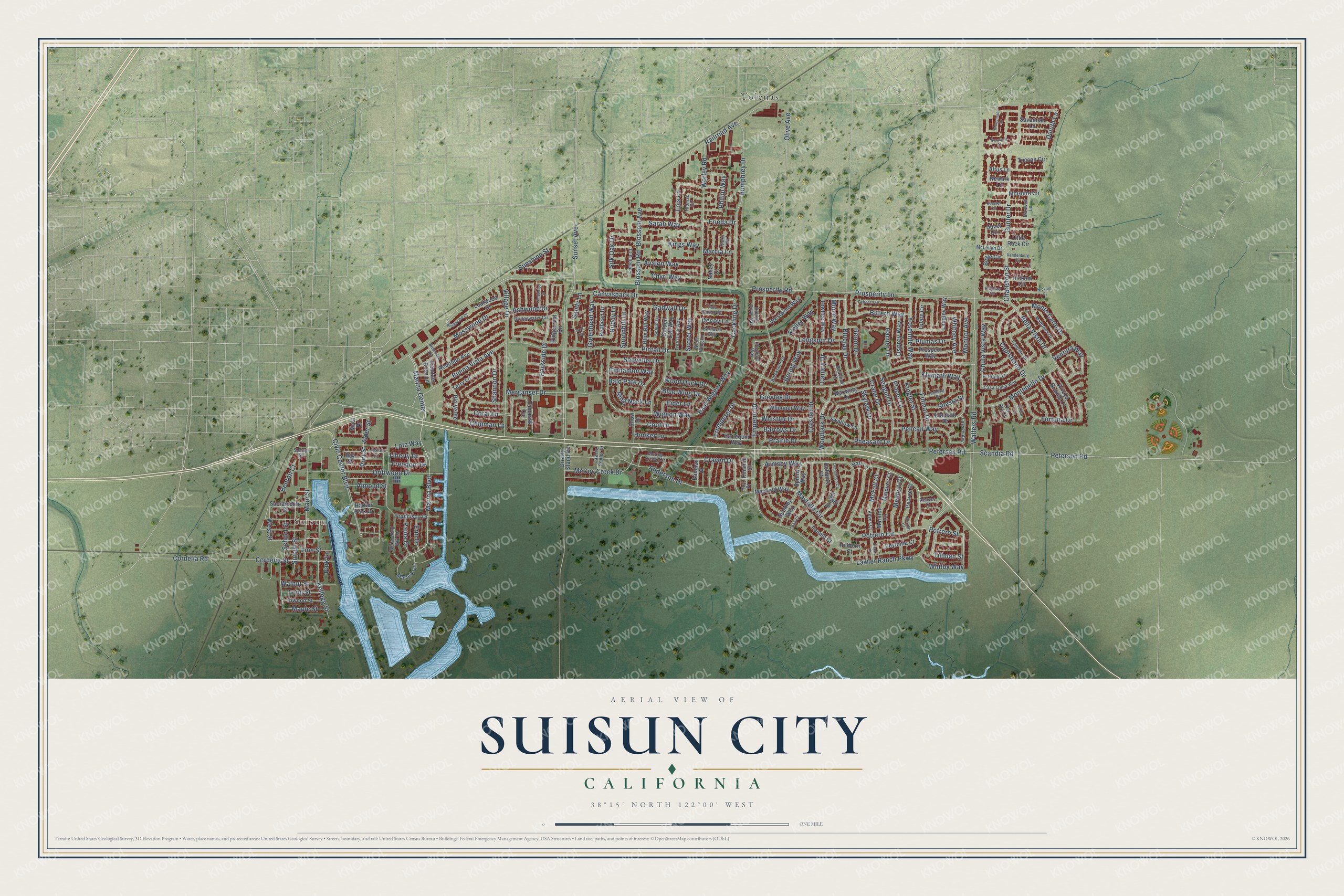
Suisun City, California Map Art
Building by building, with labeled streets and shaded relief.
12" x 18" Archival Matte Print
A Map of Home. A Work of Art.
Explore Suisun City, California from a whole new perspective. Created using aerial imagery and detailed geographic data, this map captures Suisun City building by building, with labeled streets, familiar landmarks, and shaded topographical relief that highlights the natural contours of the landscape.
Combining modern data with the timeless character of a vintage atlas, this map is just as interesting up close as it is beautiful on the wall. Whether you grew up in Suisun City, spent memorable years there, or call it home today, this unique map is a great way to celebrate a place that means something to you. Zoom in on the preview to look for your street, and then order a print to put your memories on the wall.
Three ways to hang it

Unframed archival matte, a black wood frame or a white wood frame.
Up close
Geography Worth Displaying
This map was created using accurate cartographic data and authoritative geographic sources, including the U.S. Geological Survey and the Census Bureau. The map brings together terrain, waterways, roads, and building detail. The majority of the streets are labeled, houses are accurately depicted, and the topography is derived from government sources. Combining local data with carefully composed color and shading leads to this beautifully detailed Suisun City artwork for your wall.
Rather than simply showing street outlines, we’ve included as many of the street names as we could reasonably fit on the map while keeping their names legible. Zoom in on the high resolution preview to see exactly what’s on the map. We truly set out to create a statement piece for anyone who loves Suisun City. So whether it’s for you, or a gift for someone you love, we hope this map of Suisun City brings back fond memories.
Read the story behind this map of Suisun City, California from 2026.

Find your street
Names on the Suisun City map
Every name below is printed on this map. Look for your street, your school, the park where you played, or the pond down the road.
Places and landmarks2
- Suisun
- Tolenas
Streets and roads232
- Potrero Circle
- Potrero Street
- Tillman Street
- Cackling Drive
- Alder Street
- Trumpeter Drive
- Railroad Avenue
- Marina Center
- Emperor Drive
- Pintail Drive
- Sunset Avenue
- Walters Road
- Lawler Ranch Parkway
- Marina Boulevard
- Peterson Road
- Scandia Road
- Mayfield Circle
- Civic Center Boulevard
- Cordelia Road
- Gunter Drive
- Bella Vista Drive
- Main Street
- Worley Road
- Wigeon Way
- Anderson Drive
- Humphrey Drive
- Village Drive
- Canvasback Drive
- Driftwood Drive
- Prosperity Lane
Show all 232 streets
- Blossom Road
- Lotz Way
- Klamath Way
- School Street
- Blossom Avenue
- Petersen Road
- Merganser Drive
- Chula Vista Way
- Crested Drive
- Prosperity Road
- Buena Vista Avenue
- Kellogg Street
- Chyrl Way
- Montebello Drive
- Capistrano Drive
- Mosswood Drive
- Bluejay Drive
- Longspur Drive
- Fulmar Drive
- Monitor Avenue
- Suisun Street
- Cordelia Street
- McCoy Creek Drive
- Pelican Way
- Fortuna Drive
- Parkside Drive
- Spoonbill Lane
- Phillip Way
- East Wigeon Way
- Pheasant Drive
- Honker Lane
- Ventura Way
- Seagull Drive
- Charlston Street
- Yosemite Way
- Armsby Way
- Woodlark Drive
- Bittern Way
- Lois Lane
- Duluth Lane
- Crane Drive
- Chipman Lane
- Sarah Way
- Kings Way
- Avalon Way
- Silk Oak Drive
- Heron Drive
- Monte Carlo Drive
- Whitby Way
- Whitney Avenue
- Sandy Lane
- Canary Drive
- Harrier Drive
- Shoveller Drive
- Whistler Drive
- Greylag Drive
- Barrows Drive
- Almond Street
- Prairie Drive
- Greenhead Way
- Craven Drive
- Walnut Street
- Gadwall Drive
- Coot Drive
- Wood Duck Drive
- Blue Wing Drive
- Scoter Way
- Ruddy Lane
- Osprey Way
- Skylark Drive
- Kinglet Street
- West Street
- Eider Lane
- Shannon Drive
- Bering Way
- Ring Neck Lane
- Line Street
- Sunshine Street
- Plumas Drive
- Cinnamon Way
- Ashwood Drive
- Maple Street
- Shasta Street
- Olive Avenue
- Murre Way
- Long Street
- Paula Drive
- Coral Lane
- Bald Pate Drive
- Freedom Drive
- Placer Lane
- Liberty Drive
- Steller Way
- McFall Court
- Erin Drive
- Marcia Lane
- Benton Court
- Frieda Drive
- Decoy Lane
- Meehan Court
- Port Street
- Park Lane
- McGuire Circle
- Golden Eye Way
- Tamarisk Circle
- Tucson Circle
- Rodondo Avenue
- Hickam Circle
- Langley Way
- Tulare Circle
- Marina Circle
- Little Rock Circle
- Harbor Park Drive
- Whooper Way
- Mayfield Way
- Arroyo Grande Lane
- Dover Circle
- Beale Circle
- Ridgecrest Circle
- Terry Lane
- Sacramento Street
- Prospect Way
- Klamath Drive
- Waxwing Drive
- Westwind Way
- Blue Bill Way
- Rio Verde
- Grizzly Island Road
- Elwood Street
- Towhee Way
- Swallow Lane
- Bay Street
- Harlequin Way
- Spinney Way
- Leafwood Court
- Newark Lane
- Francisco Drive
- Savannah Lane
- Redhead Drive
- Snow Drive
- Maloney Court
- Peytonia Court
- Marston Court
- Rambler Rose Lane
- Spinny Way
- Engell Court
- Bauman Drive
- Fennie Court
- Pearce Court
- Hillborn Court
- Kinsmill Court
- Dobbins Court
- Altus Lane
- Hall Lane
- Mast Drive
- Nancy Court
- Whispering Bay Lane
- Bridgewater Circle
- Palermo Drive
- Josiah Circle
- McCoy Creek Circle
- Blackspur Drive
- Madonna Drive
- Thomas Circle
- Casa Loma Way
- Maxwell Lane
- Tree Duck Way
- Scaup Lane
- El Prado Lane
- Pochard Way
- Hidden Cove Way
- Barnacle Way
- Tule Goose Drive
- White Wing Lane
- Lassen Avenue
- McLellan Drive
- Keyes Court
- Camellia Court
- Lawler Center Drive
- Bobolink Court
- Ricky Court
- Reeves Court
- Spring Street
- Del Oro Court
- Hoyt Court
- Stoneman Drive
- Rebecca Drive
- Vandenberg Circle
- Andrews Circle
- Keesler Circle
- Humbolt Drive
- Brookside Drive
- Lark Circle
- Limewood Street
- Birchwood Court
- Keyes Lane
- Donaldson Court
- Carswell Court
- El Mar Court
- Cohn Court
- Perkins Court
- Hickam Court
Names are listed as they appear on the printed map. Zoom into the product photos to find them.
About Suisun City, California
Suisun City is a city of 29,518 people in Solano County, on the edge of the Suisun Marsh. The gold rush gave farming in the area a big push, and in 1850 Curtis Wilson and John Baker sailed up the Suisun Slough to the site of today's city, the first Americans to make that trip. The town was founded in the 1850s, and its place on the water made it a good spot for trade and shipping during the Gold Rush.
In 1868 and 1869 the California Pacific Railroad linked the town to the first transcontinental railroad at Sacramento. By 1879 the Central Pacific owned that line. It sent its overland trains from Port Costa on the ferry Solano to Benicia, then over the Suisun Marsh to Suisun City, so the town sat right on the main route from San Francisco to Ogden.
- The fire of 1888In 1888 a fire burned much of downtown. Among the losses were the Orkel grain warehouses, the Union Hotel, Crowley's saloon and the Robert Hotel. Residents talked about giving up on the town. Instead they rebuilt it and raised money for a waterworks, so they could fight the next fire better.
- Where the west wind blowsThe city is named for the nearby Suisun Bay, which takes its name from the Suisun people, who lived here. In the Patwin language, Suisun means "where the west wind blows."
- A marsh of 84,000 acresSuisun City borders the Suisun Marsh. At 84,000 acres, it is the largest unbroken estuarine marsh left on the west coast of North America.
- Suburban growthIn the 1960s and 1970s the Bay Area's suburbs spread into rural Solano County, and Suisun City grew fast. Interstate 80 was built just outside the city in the 1960s, and trucks took over freight that had once moved by rail and water.
Keep exploring California
Suisun City is one of 1,990 California towns we've mapped. Every dot on the map is a print of its own.
The search covers every state, California first.
Near Suisun City
Order 2 or more town maps and save 10%. Shown in the size and finish you picked above, so they hang as a set.
- Fairfield 12" x 18" / Archival Matte Print $39.99
- Cordelia 12" x 18" / Archival Matte Print $39.99
- Vacaville 12" x 18" / Archival Matte Print $39.99


More maps nearby: Green Valley, Elmira, Hartley, Allendale and Napa Junction.
The art of mapping a place
How This Map Was Made
Real places. Remarkable detail. Discover the layers that turn geographic data into a map of home.

The view from above
Aerial imagery reveals the character of the land: woodland, open fields, and the patterns of a place.

The shape of the land
Elevation data brings hills, valleys, and subtle changes in the landscape into view.

The details of home
Roads, waterways, and building footprints come together to make the map feel unmistakably local.

Geography becomes art
Considered color, shading, and typography bring the layers together in a map made for your wall.


Process illustrated with Mendon, Massachusetts. Aerial imagery: USDA NAIP. Terrain: USGS 3D Elevation Program. Map details and finished artwork: KNOWOL.
The Details
About This Print
Choose an archival matte print, or a black or white Ayous wood frame. The archival matte print is unframed.
Select your size and finish above to see the matching product image and price.
Materials & Craftsmanship
A contemporary map with the character of a classic atlas, printed on archival matte paper. Optional frames are made from Ayous wood.
Your printed map does not include the watermark shown in the full-map preview.
Shipping & Delivery
Free shipping within the United States. Every print is made to order in the USA.
Buying a gift? Add a note in your cart and we'll include it. We never put prices in the package.
Prints ship within 2 to 3 business days. Allow 7 to 10 days total from ordering for delivery. Timing may vary during holidays or periods of high order volume.
Read our shipping policy.
Returns and damaged prints
Each print is made to order. Change-of-mind refunds are not available after production.
If your print arrives damaged, misprinted or incorrect, contact support@knowol.com within 30 days of receiving it. Include your order number, photos and a description of the issue.
Read our full refund and replacement policy. For questions about your order, email support@knowol.com.