


Search for another town


Free U.S. delivery 7 to 10 days after you order
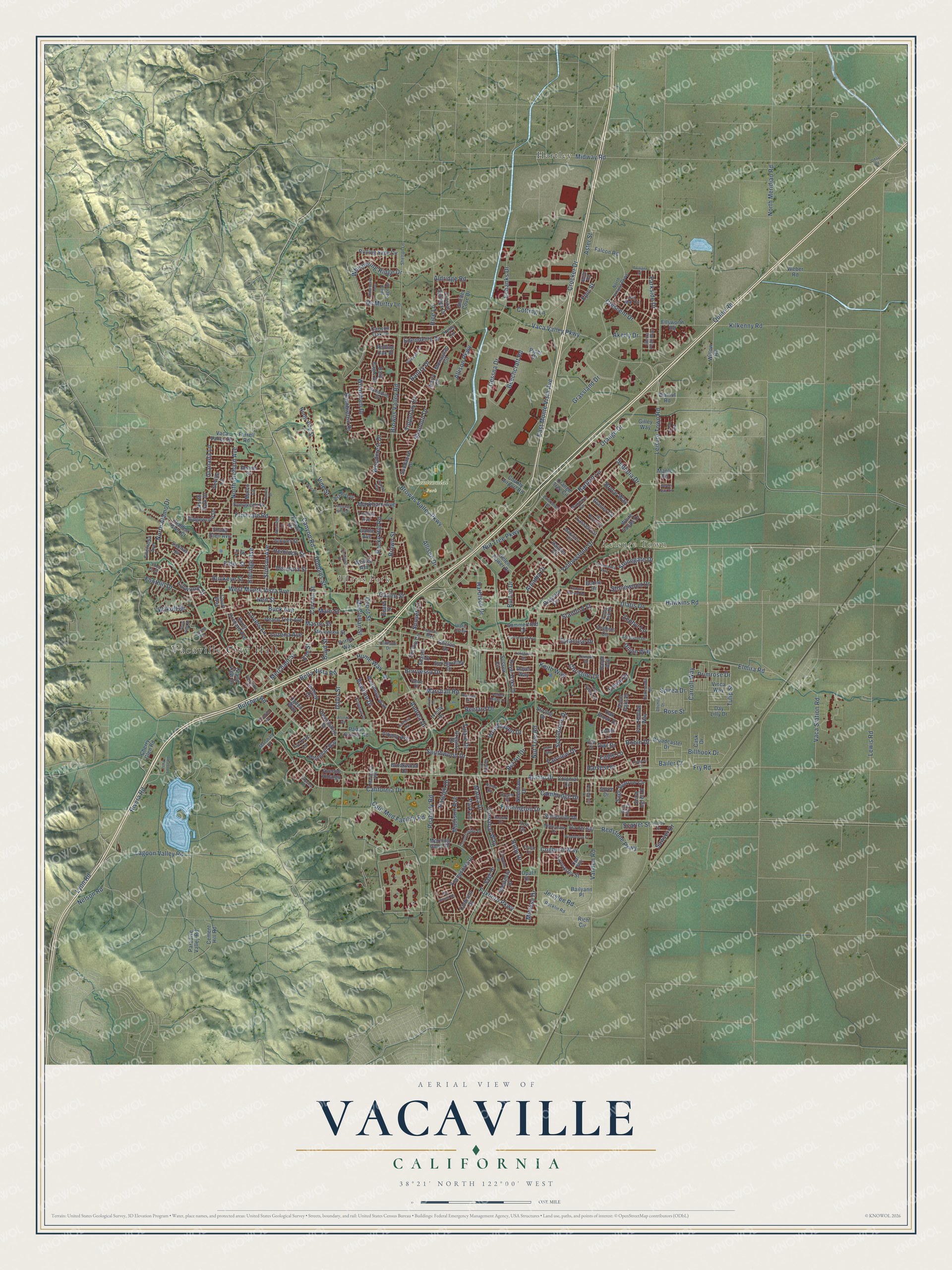
Vacaville, California Map Art
Building by building, with labeled streets and shaded relief.
12" x 18" Archival Matte Print
A Map of Home. A Work of Art.
Explore Vacaville, California from a whole new perspective. Created using aerial imagery and detailed geographic data, this map captures Vacaville building by building, with labeled streets, familiar landmarks, and shaded topographical relief that highlights the natural contours of the landscape.
Combining modern data with the timeless character of a vintage atlas, this map is just as interesting up close as it is beautiful on the wall. Whether you grew up in Vacaville, spent memorable years there, or call it home today, this unique map is a great way to celebrate a place that means something to you. Zoom in on the preview to look for your street, and then order a print to put your memories on the wall.
Three ways to hang it

Unframed archival matte, a black wood frame or a white wood frame.
Up close
Geography Worth Displaying
This map was created using accurate cartographic data and authoritative geographic sources, including the U.S. Geological Survey and the Census Bureau. The map brings together terrain, waterways, roads, and building detail. The majority of the streets are labeled, houses are accurately depicted, and the topography is derived from government sources. Combining local data with carefully composed color and shading leads to this beautifully detailed Vacaville artwork for your wall.
Rather than simply showing street outlines, we’ve included as many of the street names as we could reasonably fit on the map while keeping their names legible. Zoom in on the high resolution preview to see exactly what’s on the map. We truly set out to create a statement piece for anyone who loves Vacaville. So whether it’s for you, or a gift for someone you love, we hope this map of Vacaville brings back fond memories.
Read the story behind this map of Vacaville, California from 2026.

Find your street
Names on the Vacaville map
Every name below is printed on this map. Look for your street, your school, the park where you played, or the pond down the road.
Places and landmarks5
- Vacaville City Hall
- Leisure Town
- Ulatis Park
- Centennial Park
- Hartley
Streets and roads317
- Alamo Drive
- Elmira Road
- Peabody Road
- Akerly Drive
- West Monte Vista Avenue
- Dobbins Street
- Elm Street
- Canyon Road
- Bella Vista Road
- Vaca Valley Parkway
- East Monte Vista Avenue
- Fruitvale Road
- Vanden Road
- Leisure Town Road
- Nut Tree Road
- Orange Drive
- Marshall Road
- Allison Drive
- Midway Road
- Browns Valley Road
- Lagoon Valley Road
- California Drive
- Ulatis Drive
- Nut Tree Parkway
- North Alamo Drive
- Ruby Drive
- Eubanks Drive
- Foxboro Parkway
- Vine Street
- Davis Street
Show all 317 streets
- Quinn Road
- North Orchard Avenue
- Christine Drive
- Beelard Drive
- Buck Avenue
- Aldridge Road
- Markham Avenue
- Yellowstone Drive
- Fry Road
- Browns Valley Parkway
- Allison Parkway
- Eldridge Avenue
- Rivera Road
- Harbison Drive
- Tipperary Drive
- Crescent Drive
- Carroll Way
- Nelson Road
- Shannon Drive
- Tulare Drive
- Brown Street
- Wrentham Drive
- Cessna Drive
- Woodcrest Drive
- Deodara Street
- McMurtry Lane
- Merchant Street
- Lyon Road
- Southwood Drive
- Grassland Drive
- Andrea Drive
- Scottsdale Drive
- Callen Street
- Woodhaven Drive
- Edwin Drive
- Whispering Ridge Drive
- Mason Street
- Berryessa Drive
- Kilkenny Road
- Wykoff Drive
- Bowline Drive
- Farmington Drive
- Bel Air Drive
- Rambleton Drive
- Crocker Drive
- Aster Street
- Marna Drive
- Stinson Avenue
- Vaca Station Road
- Stonegate Drive
- Hemlock Street
- Stonewood Drive
- Edenderry Drive
- Burton Drive
- Lovers Lane
- Jerrylee Road
- Calif Med Facility Road
- Rocky Hill Road
- Elder Street
- Cernon Street
- Parkside Drive
- Granada Lane
- Redstone Parkway
- Butcher Road
- Bailer Court
- Rice Lane
- Buckeye Street
- Fairview Drive
- Arcadia Drive
- Beechcraft Road
- Bantry Drive
- Hawkins Road
- North Meridian Road
- Linwood Street
- Keith Way
- Cinnabar Way
- Foothill Drive
- Sequoia Drive
- Lewis Road
- Madison Avenue
- Tulip Street
- Epic Street
- Raleigh Drive
- Billhook Drive
- Hume Way
- McClellan Street
- Harvest Drive
- Cotting Lane
- Cambridge Drive
- Cogburn Way
- Primrose Drive
- Mimosa Drive
- Luzena Avenue
- Stanford Street
- Sawyer Drive
- Zephyr Lane
- Rose Street
- Spirea Drive
- Boyd Street
- Syracuse Drive
- Main Street
- Sunset Lane
- Neil Street
- Bartlett Lane
- Bryce Way
- Scarlet Street
- Union Way
- Robin Drive
- Depot Street
- Owl Drive
- Eagle Lane
- Park Lane
- Bishop Drive
- Boone Drive
- Arabian Circle
- Crystal Springs Drive
- Fox Hollow Way
- Day Lilly Drive
- Youngsdale Drive
- South Orchard Avenue
- Shady Glen Avenue
- Bald Eagle Drive
- Rolling Sage Circle
- Colonial Circle
- Rainier Circle
- Orange Tree Circle
- Arbor Oaks Drive
- Peach Tree Avenue
- Lassen Circle
- Sage Sparrow Circle
- Regency Circle
- Shasta Drive
- White Sands Drive
- Glacier Circle
- Springvalley Drive
- Trinity Drive
- Cement Hill Road
- North Vine Street
- Westgate Drive
- Via del Sol
- Stevenson Street
- La Cruz Lane
- Weatherly Way
- Morning Glory Drive
- Needham Drive
- Piper Drive
- Royal Oaks Drive
- Monaghan Circle
- Del Rio Circle
- Cherry Glen Road
- Paradise Valley Road
- Ogden Way
- Rich Circle
- Derry Circle
- Somerville Drive
- Fir Street
- Whitehall Way
- Helen Power Drive
- Lancaster Street
- Ridgewood Drive
- Cookson Street
- Summerfield Drive
- Oak Brook Drive
- Bailyann Place
- Devonshire Drive
- Sage Drive
- Willow Road
- Evergreen Drive
- Juniper Street
- Falcon Road
- Broadcaster Drive
- Padan School Road
- Sundance Drive
- Hidden Glen Court
- Stirling Drive
- Gilley Way
- Salinas Drive
- Ellsworth Road
- Albany Avenue
- Weber Road
- Gregory Drive
- Brookwood Drive
- Chelan Drive
- Dennis Drive
- Sussex Circle
- Shelter Cove Drive
- Grand View Drive
- Wesley Avenue
- Encinosa Avenue
- County Airport Road
- Cask Drive
- Vaca Valley Road
- Snow Egret Drive
- Seville Lane
- Porter Way
- Ralph Avenue
- Canyon Oak Drive
- Dover Way
- Vinca Way
- North Park Drive
- Lomita Avenue
- Avenue Hidalgo
- Court Way
- Beard Street
- Marco Lane
- Gable Avenue
- Farrell Road
- Violet Lane
- Joyce Drive
- Rolling Oak Drive
- Maple Road
- Walnut Road
- Kells Circle
- Opal Drive
- Pintail Drive
- Iron Drive
- Sierra Peak Way
- Cliffside Drive
- Mandarin Circle
- North Village Parkway
- Newcastle Drive
- Kingman Drive
- McKinley Circle
- Ballindine Drive
- Shelton Lane
- Atchison Drive
- Topaz Circle
- Gentry Circle
- Wild Sage Drive
- Aaron Circle
- Temple Drive
- Del Mar Circle
- Oak Valley Drive
- Countryside Drive
- Rocklin Road
- Alta Mira Drive
- Tahoe Drive
- Mariposa Avenue
- Fairoaks Drive
- Lawrence Drive
- Oakmeade Drive
- Dream Street
- Star Lilly Drive
- Opal Way
- Guild Road
- Marshall Drive
- Spring Lane
- Valley Oak Drive
- Ulatis Creek
- Owl Court
- Aegean Way
- Elderberry Loop
- Isle Royale Circle
- Stonecastle Way
- Cooper School Road
- Turquoise Street
- Chateau Circle
- Portsmouth Avenue
- Providence Place
- Timber Drive
- Clark Way
- Fox Hound Road
- Bluewater Drive
- Silver Drive
- Wimbledon Court
- Klamath Drive
- Hartford Avenue
- Vine Place
- Kodiak Drive
- Del Rey Drive
- Pena Adobe Road
- Zachary Drive
- Alonzo Road
- Twilight Street
- Cosmos Drive
- Vista View Drive
- Zinfandel Court
- Skyview Place
- Sweet Bay Circle
- Lakehurst Drive
- Westfield Lane
- Portofino Avenue
- Vineyard Hills Court
- Amber Ridge Lane
- Granite Way
- Santa Fe Court
- Oday Road
Names are listed as they appear on the printed map. Zoom into the product photos to find them.
About Vacaville, California
Vacaville is a city of 102,386 people in Solano County, where the Sacramento Valley meets the Vaca Mountains. Long before settlers came, the Patwin people lived here, and the Ululato tribelet kept a village beside Ulatis Creek in what is now downtown. In 1842 a Mexican land grant of 44,000 acres went to Juan Manuel Cabeza Vaca along with Juan Felipe Peña, and both families settled in Lagoon Valley that same year.
Talks to sell part of the grant to William McDaniel began in August 1850. On December 13, 1851, the two sides signed an agreement that gave him nine square miles for $3,000, and McDaniel agreed to name the new town for Vaca. The first town plan was drawn up on that land, and Vacaville became a city in 1892.
- Fruit shipping from 1880In 1880 Leonard Buck founded two firms. The L.W. and F.H. Buck Company was among the state's first to sell fruit at auction, and he also started the California Fruit Shipping Association. The good soil of the Vaca Valley soon drew many more produce companies and farms, and many Japanese and Chinese immigrants came to work for the fruit firms.
- Peña Adobe, built in 1842Juan Felipe Peña's adobe home, built the year his family arrived, is the oldest building still standing in Vacaville. It now sits in Peña Adobe Park in Lagoon Valley, near the Mowers-Goheen Museum.
- First schools, 1885 and 1898Ulatis School opened in 1885 as the town's first grade school. Vacaville Union High School, its first high school, was built in 1898.
- The Centennial muralsBetween 1992 and 1995, artist Guillermo Wagner Granizo set 20 ceramic-tile murals into three walls near City Hall. They show Vaca, Peña and McDaniel, the early fruit trade, the first schools, parades and the Nut Tree, a roadside fruit and nut stand from the 1920s.
Keep exploring California
Vacaville is one of 1,990 California towns we've mapped. Every dot on the map is a print of its own.
The search covers every state, California first.
Near Vacaville
Order 2 or more town maps and save 10%. Shown in the size and finish you picked above, so they hang as a set.
- Elmira 12" x 18" / Archival Matte Print $39.99
- Hartley 12" x 18" / Archival Matte Print $39.99
- Allendale 12" x 18" / Archival Matte Print $39.99


More maps nearby: Fairfield, Suisun City, Dixon, Winters and Green Valley.
The art of mapping a place
How This Map Was Made
Real places. Remarkable detail. Discover the layers that turn geographic data into a map of home.

The view from above
Aerial imagery reveals the character of the land: woodland, open fields, and the patterns of a place.

The shape of the land
Elevation data brings hills, valleys, and subtle changes in the landscape into view.

The details of home
Roads, waterways, and building footprints come together to make the map feel unmistakably local.

Geography becomes art
Considered color, shading, and typography bring the layers together in a map made for your wall.


Process illustrated with Mendon, Massachusetts. Aerial imagery: USDA NAIP. Terrain: USGS 3D Elevation Program. Map details and finished artwork: KNOWOL.
The Details
About This Print
Choose an archival matte print, or a black or white Ayous wood frame. The archival matte print is unframed.
Select your size and finish above to see the matching product image and price.
Materials & Craftsmanship
A contemporary map with the character of a classic atlas, printed on archival matte paper. Optional frames are made from Ayous wood.
Your printed map does not include the watermark shown in the full-map preview.
Shipping & Delivery
Free shipping within the United States. Every print is made to order in the USA.
Buying a gift? Add a note in your cart and we'll include it. We never put prices in the package.
Prints ship within 2 to 3 business days. Allow 7 to 10 days total from ordering for delivery. Timing may vary during holidays or periods of high order volume.
Read our shipping policy.
Returns and damaged prints
Each print is made to order. Change-of-mind refunds are not available after production.
If your print arrives damaged, misprinted or incorrect, contact support@knowol.com within 30 days of receiving it. Include your order number, photos and a description of the issue.
Read our full refund and replacement policy. For questions about your order, email support@knowol.com.