
Search for another town


Free U.S. delivery 7 to 10 days after you order
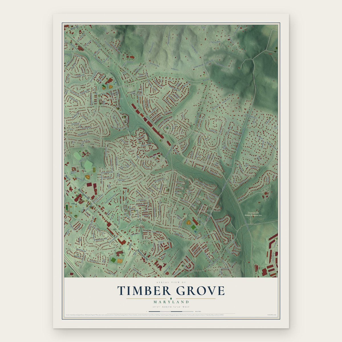
Timber Grove, Maryland Map Art
Building by building, with labeled streets and shaded relief.
12" x 18" Archival Matte Print
A Map of Home. A Work of Art.
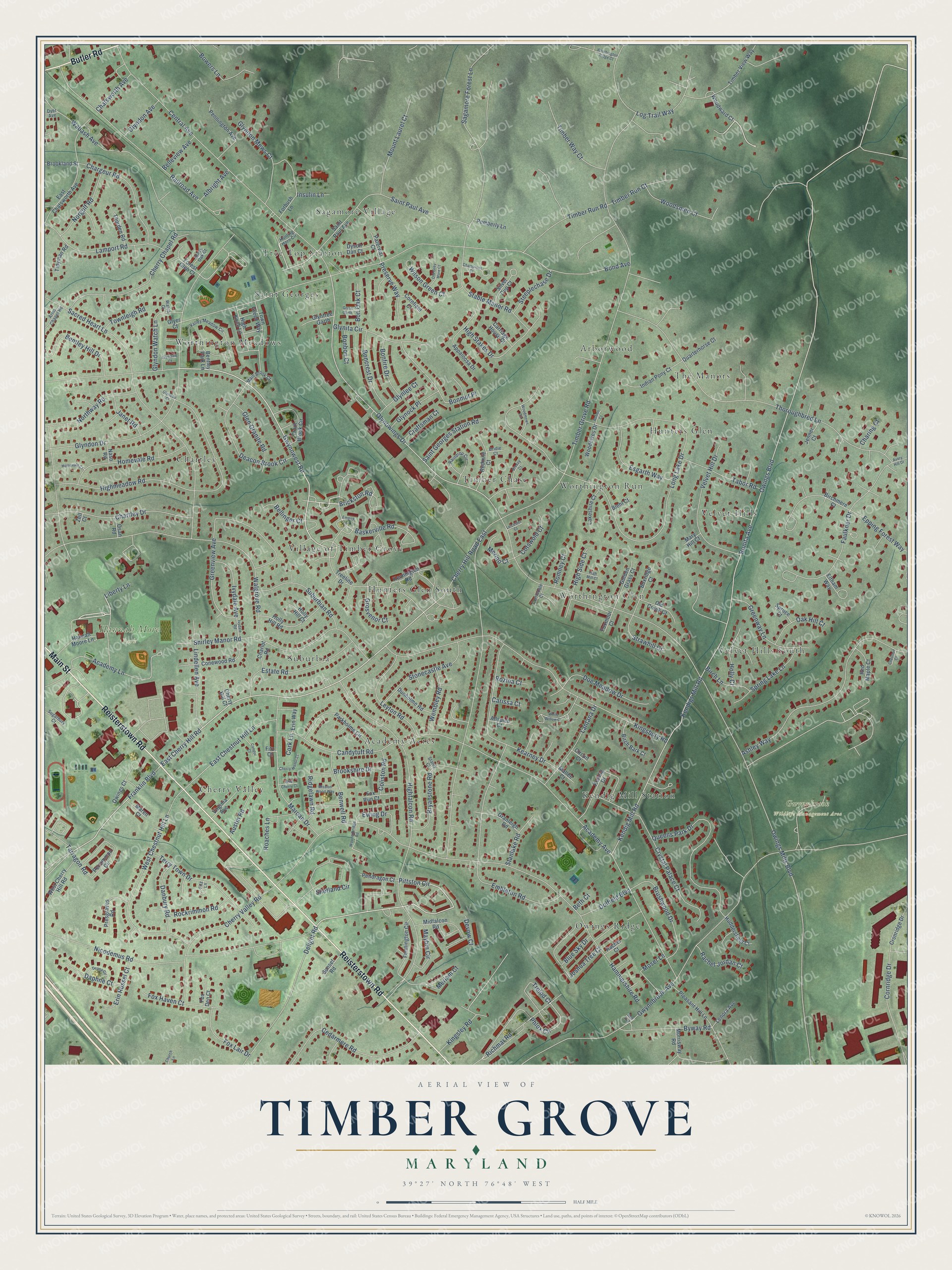
Explore Timber Grove, Maryland from a whole new perspective. Created using aerial imagery and detailed geographic data, this map captures Timber Grove building by building, with labeled streets, familiar landmarks, and shaded topographical relief that highlights the natural contours of the landscape.
Combining modern data with the timeless character of a vintage atlas, this map is just as interesting up close as it is beautiful on the wall. Whether you grew up in Timber Grove, spent memorable years there, or call it home today, this unique map is a great way to celebrate a place that means something to you. Zoom in on the preview to look for your street, and then order a print to put your memories on the wall.
Three ways to hang it

Unframed archival matte, a black wood frame or a white wood frame.
Up close
Geography Worth Displaying
This map was created using accurate cartographic data and authoritative geographic sources, including the U.S. Geological Survey and the Census Bureau. The map brings together terrain, waterways, roads, and building detail. The majority of the streets are labeled, houses are accurately depicted, and the topography is derived from government sources. Combining local data with carefully composed color and shading leads to this beautifully detailed Timber Grove artwork for your wall.
Rather than simply showing street outlines, we’ve included as many of the street names as we could reasonably fit on the map while keeping their names legible. Zoom in on the high resolution preview to see exactly what’s on the map. We truly set out to create a statement piece for anyone who loves Timber Grove. So whether it’s for you, or a gift for someone you love, we hope this map of Timber Grove brings back fond memories.
Read the story behind this map: Detailed Map of Timber Grove, Maryland.

Find your street
Names on the Timber Grove map
Every name below is printed on this map. Look for your street, your school, the park where you played, or the pond down the road.
Places and landmarks22
- Gwynnbrook Wildlife Management Area
- Hannah More Park
- Sagamore Village
- Velvet Hills
- Owings Ridge
- Village of Timber Grove
- Worthington Meadows
- Worthington Glen
- Academy Acres
- Cherry Valley
- Kendig Mill Station
- Arborwood
Show all 22 places
- Velvet Hills South
- Timber Chase
- Chartley
- Saint Georges
- Worthington Run
- Suburbia
- Hunters Glen
- The Manors
- Tree Top Station
- Hunters Glen South
Streets and roads271
- Reisterstown Road
- Butler Road
- Main Street
- Gwynnwest Road
- Timber Grove Road
- Pittston Circle
- East Cherry Hill Road
- Franklin Boulevard
- Brickston Road
- Phlox Circle
- Owings Mills Boulevard
- Bonita Avenue
- Owings Boulevard
- Bond Avenue
- Gwynnbrook Avenue
- Long Lake Drive
- Hammershire Road
- Academy Avenue
- Highfalcon Road
- Shirley Manor Road
- Thoroughbred Lane
- Glyndon Drive
- Kingsbury Road
- Sacred Heart Lane
- Central Avenue
- Glynowings Drive
- Walgrove Road
- Nicodemus Road
- Highmeadow Road
- Embleton Road
Show all 271 streets
- Ashley Way
- Sagamore Forest Lane
- Greenview Avenue
- West Chestnut Hill Lane
- Railroad Avenue
- Cherry Chapel Road
- Shetland Circle
- Kendig Mill Road
- Kendigs Mill Road
- Queens Park Drive
- Faulkner Drive
- Kearney Drive
- Cedarmere Road
- Delight Road
- Log Trail Way
- Chartley Drive
- Cherry Valley Road
- High Stakes Drive
- Velvet Hill Drive
- Deacon Brook Circle
- Byway Road
- Crystal Palace Court
- Lamport Road
- Cornridge Drive
- Terry Town Drive
- Estate Road
- Candytuft Road
- Mardan Drive
- Academy Lane
- Wabash Avenue
- Homevale Road
- Chargeur Road
- Glynita Circle
- East Chestnut Hill Lane
- Lantana Drive
- Baskerville Road
- Richmar Road
- Bryanstone Road
- Brushwood Drive
- Lindellen Avenue
- Bonmot Place
- Joshua Tree Court
- Stonecastle Avenue
- Leyton Road
- Suburbian Road
- Greenway Lane
- Northway Road
- Mount Laurel Court
- Doe Meadow Drive
- Timber Run Road
- Glyndon Mews Court
- Saint Paul Avenue
- Meriam Court
- Timber Way Court
- Bentley Hill Drive
- Esgarth Way
- Stable Manor Road
- Tabor Road
- Cherry Hill Road East
- Wilson Green Court
- Spring Lake Lane
- Insulin Lane
- Glyndon Watch Lane
- Boncrest Drive
- Norgulf Road
- Glen Granite Road
- Fox Lair Drive
- Woodsmen Court
- Saint Georges Station Road
- Ridgelawn Road
- Benwell Road
- Danbury Road
- Epping Forest Way
- Fox Haven Court
- Bowers Lane
- Ivydale Avenue
- Austin Road
- Tarragon Road
- Wembley Road
- Roaches Lane
- Maybin Circle
- Trolod Court
- Rockrimmon Road
- Timber Run Court
- Kingsley Road
- Preserve Way
- Oak Hill Court
- Erin Russel Court
- Daphne Court
- Bonfire Drive
- Glynock Place
- Ewing Drive
- Holly Court
- Steeplechase Drive
- Moser Lane
- Strawhill Court
- Rachel Jordan Court
- Stanlake Road
- Dolfield Boulevard
- Albright Avenue
- Cotswold Court
- Bellinger Court
- Birch Lane
- Brookshire Drive
- Janet Road
- Glynlee Court
- Chatsworth Avenue
- Grosvenor Court
- Glyndon Avenue
- Merino Court
- Townleigh Road
- High Side Court
- Craftsman Court
- Coliston Road
- Belleview Avenue
- Bon Oak Court
- Blue Sky Drive
- Cork Lane
- Romney Court
- Bonbon Court
- Charing Court
- Rozina Court
- Devow Court
- Carissa Court
- Liberty Lane
- Beth Court
- Treeline Drive
- Kennington Road
- East Chatsworth Avenue
- Timber View Way
- Hannah Moore Lane
- Parkholme Circle
- Appaloosa Drive
- Persimmon Circle
- Conewood Road
- Pennington Avenue
- Holly Hill Road
- Birchmere Court
- Town Green Way
- Fennington Circle
- Indian Pony Court
- Trout Brook Circle
- Morrisway Road
- Pleasant Hill Lane
- Owings Court
- West Cherry Hill Road
- Kendig Drive
- Silver Cup Court
- Presgraves Road
- Redmile Court
- Boxridge Court
- Golden Grass Court
- Bentley Park Lane
- Cronridge Drive
- High Knob Lane
- Birch Bark Court
- Old Creek Court
- Dunholme Road
- Granleigh Road
- Forest Glen Court
- Quarterhorse Court
- Huddersfield Court
- Pendragon Court
- Erin Way
- Lakeshire Court
- Midfalcon Road
- Red Maple Court
- Virginia Avenue
- Thorden Road
- Woodward Court
- Woodelves Drive
- Lenora Avenue
- Glyntree Garth
- Pemberly Lane
- Brookland Street
- Fox Run Court
- Paterwal Court
- Circuit Court
- Carriage House Court
- Tidyman Road
- Dyson Dan Court
- Forbush Lane
- Sunset Road
- Chariot Road
- Cornfield Court
- Jenner Court
- Maren Court
- Foxmoor Court
- Fox Den Court
- Allspice Court
- Holly Hill Court
- Spruce Court
- Biehl Court
- Eltham Way
- Mallee Court
- Rachel Court
- Naso Road
- Mary Hill Court
- Osan Road
- Cherry Hill Court
- Glyer Court
- Fitz Court
- Zell Court
- Hunting Horn Circle
- Valley Meadow Circle
- Raindrop Circle
- Black Oak Court
- Main Brook Court
- Arms Chapel Road
- Sugarbury Court
- Corriedale Court
- Bridle Court
- Staley Court
- Dyer Avenue
- Watch Court
- Fitz Lane
- Ivydale Road
- White Willow Court
- Empire Court
- Champions Court
- Deana Circle
- Woodmews Circle
- Cherry Manor Court
- Mission Wood Way
- Breezy Court
- Woodenbridge Road
- Old Grey Mare Court
- Glyndale Court
- Worthington Ridge Court
- Homevale Court
- Candor Court
- High Mill Court
- Wild Cherry Court
- Leicester Court
- Glynn Garth
- Chestnut Court
- Avery Hill Drive
- Glyndon Court
- Rohan Court
- Church Lane
- Bell Avenue
Names are listed as they appear on the printed map. Zoom into the product photos to find them.
Keep exploring Maryland
Timber Grove is one of 881 Maryland towns we've mapped. Every dot on the map is a print of its own.
The search covers every state, Maryland first.
Near Timber Grove
Order 2 or more town maps and save 10%. Shown in the size and finish you picked above, so they hang as a set.
- Reisterstown 12" x 18" / Archival Matte Print $39.99
- Glyndon 12" x 18" / Archival Matte Print $39.99
- Owings Mills 12" x 18" / Archival Matte Print $39.99


More maps nearby: Garrison, Randallstown, Pikesville, Hernwood and Mays Chapel.
The art of mapping a place
How This Map Was Made
Real places. Remarkable detail. Discover the layers that turn geographic data into a map of home.

The view from above
Aerial imagery reveals the character of the land: woodland, open fields, and the patterns of a place.

The shape of the land
Elevation data brings hills, valleys, and subtle changes in the landscape into view.

The details of home
Roads, waterways, and building footprints come together to make the map feel unmistakably local.

Geography becomes art
Considered color, shading, and typography bring the layers together in a map made for your wall.


Process illustrated with Mendon, Massachusetts. Aerial imagery: USDA NAIP. Terrain: USGS 3D Elevation Program. Map details and finished artwork: KNOWOL.
The Details
About This Print
Choose an archival matte print, or a black or white Ayous wood frame. The archival matte print is unframed.
Select your size and finish above to see the matching product image and price.
Materials & Craftsmanship
A contemporary map with the character of a classic atlas, printed on archival matte paper. Optional frames are made from Ayous wood.
Your printed map does not include the watermark shown in the full-map preview.
Shipping & Delivery
Free shipping within the United States. Every print is made to order in the USA.
Buying a gift? Add a note in your cart and we'll include it. We never put prices in the package.
Prints ship within 2 to 3 business days. Allow 7 to 10 days total from ordering for delivery. Timing may vary during holidays or periods of high order volume.
Read our shipping policy.
Returns and damaged prints
Each print is made to order. Change-of-mind refunds are not available after production.
If your print arrives damaged, misprinted or incorrect, contact support@knowol.com within 30 days of receiving it. Include your order number, photos and a description of the issue.
Read our full refund and replacement policy. For questions about your order, email support@knowol.com.