


Search for another town





Free U.S. delivery 7 to 10 days after you order
Waterloo, Iowa Map Art
Building by building, with labeled streets and shaded relief.
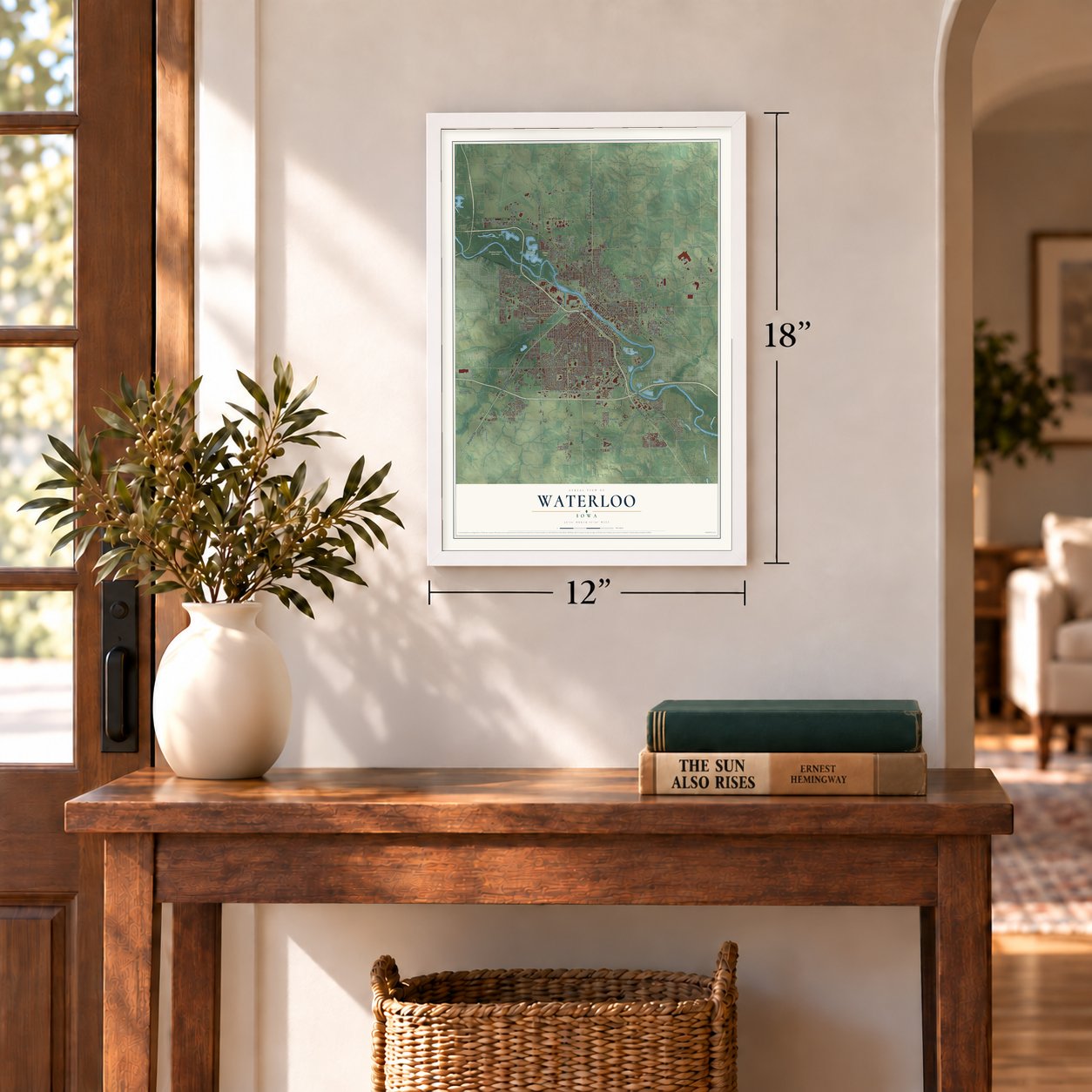
12" x 18" Archival Matte Print
A Map of Home. A Work of Art.
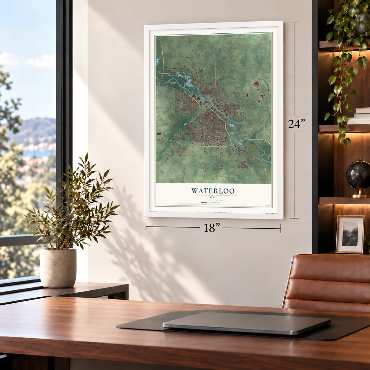
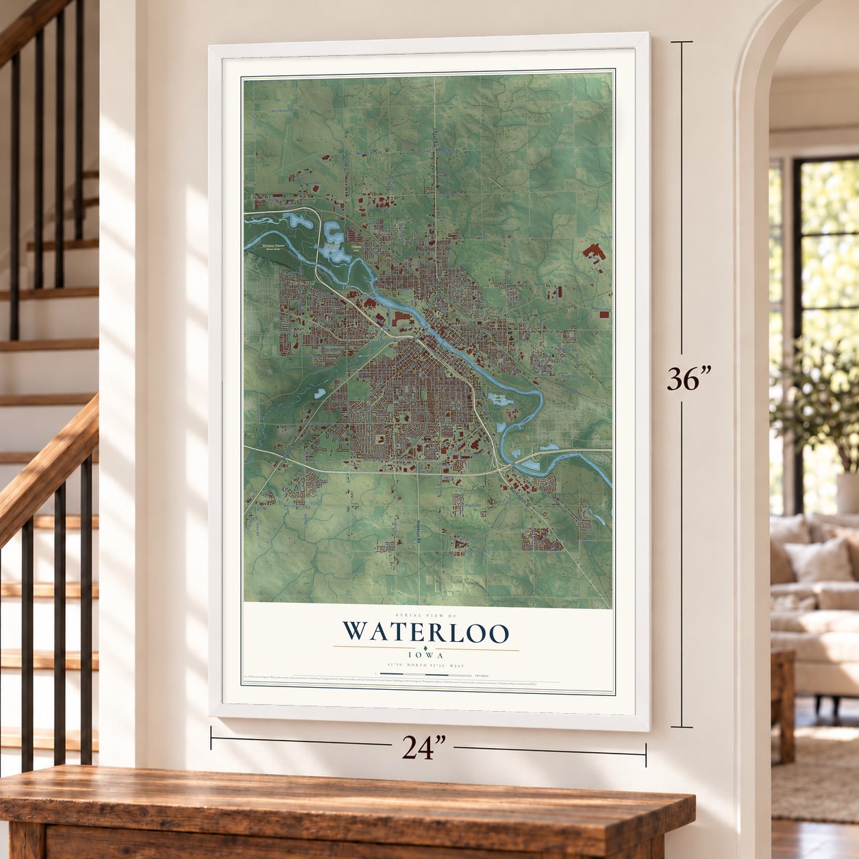
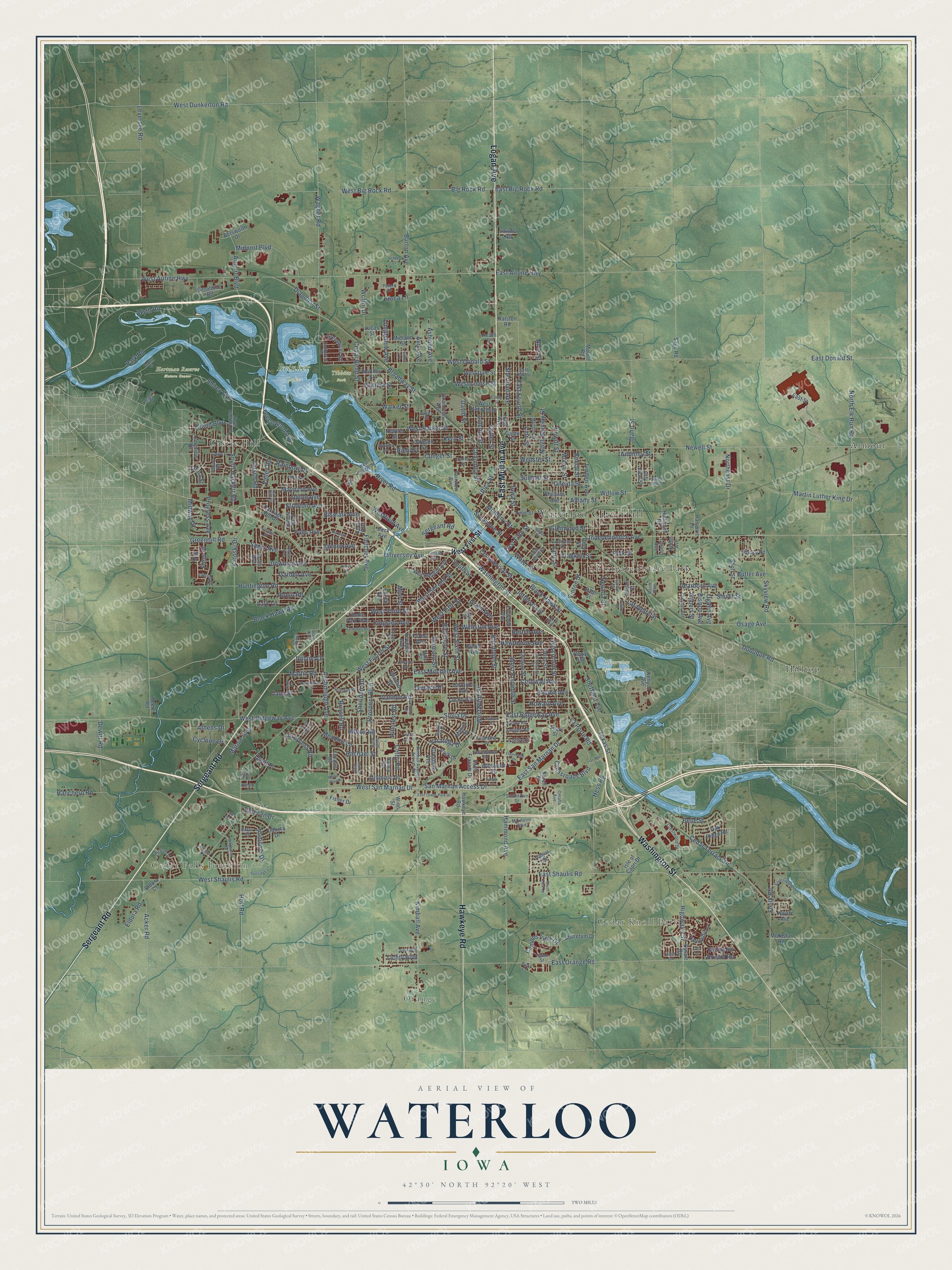
Explore Waterloo, Iowa from a whole new perspective. Created using aerial imagery and detailed geographic data, this map captures Waterloo building by building, with labeled streets, familiar landmarks, and shaded topographical relief that highlights the natural contours of the landscape.
Combining modern data with the timeless character of a vintage atlas, this map is just as interesting up close as it is beautiful on the wall. Whether you grew up in Waterloo, spent memorable years there, or call it home today, this unique map is a great way to celebrate a place that means something to you. Zoom in on the preview to look for your street, and then order a print to put your memories on the wall.
Three ways to hang it
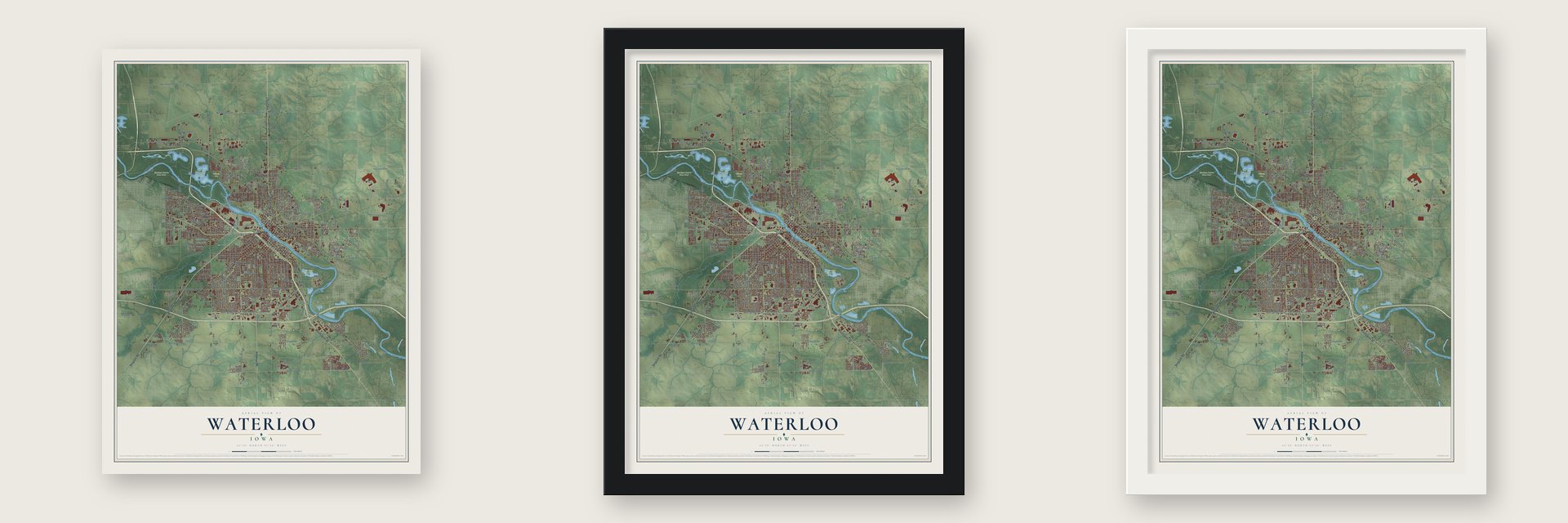
Unframed archival matte, a black wood frame or a white wood frame.
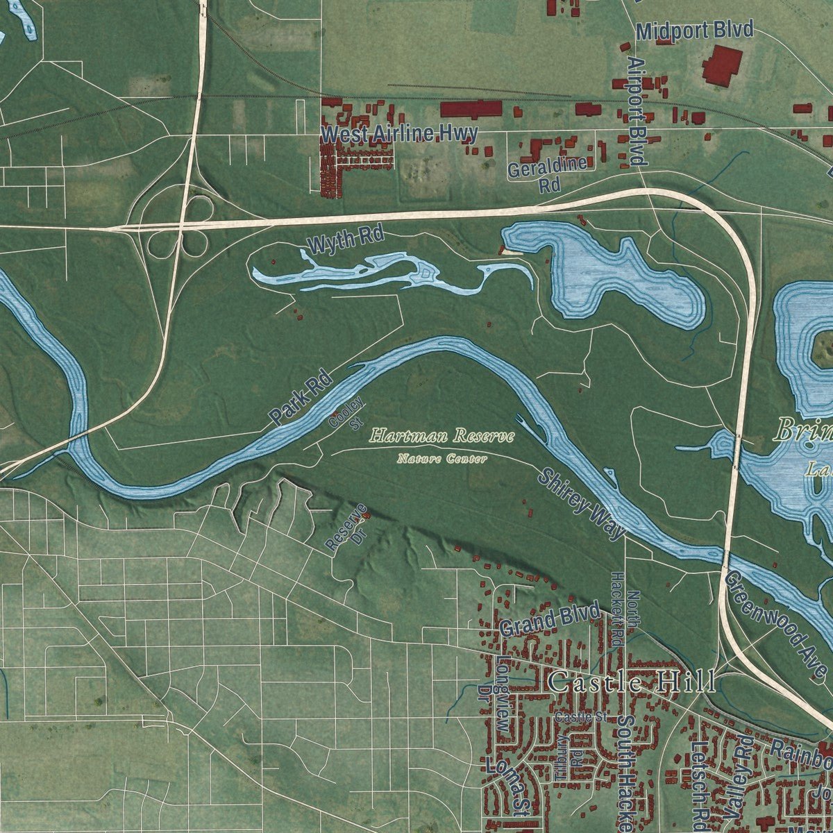
Up close
Geography Worth Displaying
This map was created using accurate cartographic data and authoritative geographic sources, including the U.S. Geological Survey and the Census Bureau. The map brings together terrain, waterways, roads, and building detail. The majority of the streets are labeled, houses are accurately depicted, and the topography is derived from government sources. Combining local data with carefully composed color and shading leads to this beautifully detailed Waterloo artwork for your wall.
Rather than simply showing street outlines, we’ve included as many of the street names as we could reasonably fit on the map while keeping their names legible. Zoom in on the high resolution preview to see exactly what’s on the map. We truly set out to create a statement piece for anyone who loves Waterloo. So whether it’s for you, or a gift for someone you love, we hope this map of Waterloo brings back fond memories.

Find your street
Names on the Waterloo map
Every name below is printed on this map. Look for your street, your school, the park where you played, or the pond down the road.
Places and landmarks12
- Waterloo City Hall
- Cedar Falls Junction
- Orange
- Cedar Knoll Park
- Brinker Lake
- Hartman Reserve Nature Center
- Riverview Recreation Area
- Tibbitts Park
- Armour
- Castle Hill
- Eastgate Estate Park
- Hilltop
Streets and roads347
- Sergeant Road
- Washington Street
- Logan Avenue
- East Mullan Avenue
- Hawkeye Road
- University Avenue
- West Third Street
- West Parker Street
- Independence Avenue
- Westfield Avenue
- La Porte Road
- River Road
- Greenwood Avenue
- East Fifth Street
- West Fifth Street
- West Airline Highway
- West Ninth Street
- Hawthorne Avenue
- Grant Avenue
- East Shaulis Road
- West Sixth Street
- South Hackett Road
- Conger Street
- Ansborough Avenue
- West Fourth Street
- Broadway Street
- East San Marnan Drive
- Hammond Avenue
- Kimball Avenue
- Newell Street
Show all 347 streets
- West Ridgeway Avenue
- East Donald Street
- West Shaulis Road
- Burton Avenue
- Lafayette Street
- West Donald Street
- West San Marnan Drive
- Wyth Road
- East Orange Road
- Dubuque Road
- Texas Street
- Idaho Street
- Martin Luther King Drive
- East Fourth Street
- East Mitchell Avenue
- Park Road
- Black Hawk Road
- West Big Rock Road
- Easton Avenue
- Hess Road
- Mulberry Street
- East Ridgeway Avenue
- Wagner Road
- Randolph Street
- Franklin Street
- Greenhill Road
- Leversee Road
- Fletcher Avenue
- Sovia Drive
- Cedar Terrace Drive
- San Marnan Access Drive
- Martin Road
- Prospect Boulevard
- North Elk Run Road
- Commercial Street
- Ranchero Road
- Katoski Drive
- Baltimore Street
- West Eleventh Street
- Jefferson Street
- Rainbow Drive
- Cornwall Avenue
- Sycamore Street
- Osage Avenue
- Big Rock Road
- Longfellow Avenue
- Williston Avenue
- Bertch Avenue
- Downing Avenue
- Falls Avenue
- Hoff Road
- Linden Avenue
- Columbia Street
- Huntington Road
- Sheridan Road
- Crossroads Boulevard
- Mobile Street
- Dearborn Avenue
- Kern Street
- Olympic Drive
- Belle Street
- Maynard Avenue
- Northeast Drive
- Riehl Street
- Sager Avenue
- Campus View Drive
- Cedar Bend Street
- Highway V37
- Shirey Way
- Wcf&n Drive
- West Second Street
- Avon Avenue
- North Barclay Street
- Bishop Avenue
- Skyview Road
- Foulk Road
- West Dunkerton Road
- Upton Avenue
- Rachael Street
- Ohio Street
- Butler Avenue
- Webster Street
- South Street
- Wisconsin Street
- Shultz Street
- Midport Boulevard
- Ashland Avenue
- Vinton Street
- Progress Avenue
- Water Street
- Vermont Street
- Lincoln Street
- Eldora Road
- Airport Boulevard
- Nevada Street
- Kingsley Avenue
- Janney Avenue
- Meadow Lane
- Howard Avenue
- Sumner Street
- Stratford Avenue
- East Airline Highway
- Sherman Avenue
- East Big Rock Road
- Beech Street
- Dewitt Road
- Midway Drive
- Saratoga Drive
- Linn Street
- Cyclone Drive
- Audubon Drive
- Sheffield Avenue
- Oneida Street
- Colby Road
- Diagonal Street
- Hewitt Street
- Gilbert Street
- Willow Street
- Bismark Avenue
- Cutler Street
- Moir Street
- Russell Road
- Glenwood Street
- Albany Street
- Acker Road
- Inverness Road
- Virginia Street
- Garden Avenue
- Utica Street
- Lane Street
- Black Hawk Street
- Marnie Avenue
- Robin Road
- Hilltop Road
- Grand Boulevard
- Anthony Street
- Walker Street
- West Louise Street
- Quail Place
- Ivanhoe Road
- Ogden Avenue
- Red Tail Drive
- Hillcrest Road
- Letsch Road
- David Street
- Athens Drive
- Terrace Drive
- Lichty Boulevard
- Bristol Road
- Lark Lane
- Valley Road
- Polk Street
- Iowa Street
- Upland Drive
- Jane Street
- Fleur Drive
- Lois Lane
- Loma Street
- Roca Lane
- Niles Street
- West First Street
- Kenyon Avenue
- Byron Avenue
- Forest Avenue
- Dawson Street
- Locke Avenue
- Dysart Road
- Oregon Street
- Fairview Avenue
- Home Park Boulevard
- Newton Street
- Midland Street
- Hanna Boulevard
- Lorraine Avenue
- Scott Avenue
- Grandview Avenue
- Heath Street
- Hope Avenue
- Geraldine Road
- West Mullan Avenue
- Gable Street
- Knoll Avenue
- Euclid Avenue
- Park Lane
- Adrian Street
- Kennedy Lane
- Rhey Street
- Saint Francis Drive
- City View Street
- Aboretum Drive
- Isle of Capri Drive
- Greenbrier Road
- Northey Street
- West Hanover Street
- Windsor Drive
- Joy Drive
- Carriage Hill Drive
- Oak Ridge Road
- West Dale Street
- Wildwood Road
- Longview Drive
- Short Street
- Shilliam Avenue
- Crestline Avenue
- Hallowell Road
- Fisher Drive
- Betsworth Drive
- Kipling Road
- Rampart Lane
- Lucas Street
- Dakota Drive
- Rocky Road
- Nancy Road
- Sears Street
- Lovejoy Avenue
- Loralin Drive
- Winn Street
- McKellar Road
- Ralston Road
- North Avenue
- Manor Street
- Lowder Road
- Sage Road
- Moline Road
- Angus Drive
- Linwood Avenue
- Rath Street
- Deere Road
- East Street
- Toland Avenue
- Lime Street
- Sarah Drive
- Eldora Court
- Rome Avenue
- Beck Avenue
- Regal Avenue
- Hale Street
- Jill Drive
- North Hackett Road
- West Conger Street
- Minnesota Street
- Allen Street
- Manson Street
- Creston Avenue
- Kimball Avenue Access Road
- Center Street
- Courtland Street
- Oleson Road
- Caras Road
- East Dale Street
- Maxhelen Boulevard
- Crestwood Drive
- Ravenwood Road
- East Ninth Street
- Southtown Drive
- Charm Drive
- Langley Road
- Columbus Drive
- Tilbury Road
- Leland Avenue
- Brees Street
- Flower Street
- Barton Avenue
- Reserve Drive
- Peters Drive
- Vision Street
- Omaha Avenue
- Rooff Avenue
- Trent Lane
- Buzz Court
- Walnut Street
- Hartman Avenue
- South Hill Drive
- Campbell Avenue
- Colorado Street
- Partridge Lane
- Silver Lake Drive
- William Drive
- Flammang Drive
- Clough Street
- Devonshire Drive
- Berkshire Road
- Winghaven Drive
- Indiana Street
- Carolina Avenue
- Sunrise Boulevard
- East Tower Park Drive
- South View Drive
- Castle Street
- West 18th Street
- Esther Street
- Violet Drive
- Candlewick Road
- West Ridge Drive
- Beverly Hills Street
- West Park Lane
- Ingersoll Road
- Helmet Avenue
- Sidehill Drive
- Lindner Drive
- South Fork Lane
- Grover Court
- Norwood Avenue
- Sonya Drive
- Doreen Avenue
- Sky Line Drive
- Bellaire Road
- Kate Street
- Movilla Street
- Home Plaza
- Cooley Street
- Kamille Court
- Grimm Street
- Lunar Lane
- Ida Street
- Alice Avenue
- Tulip Lane
Names are listed as they appear on the printed map. Zoom into the product photos to find them.
About Waterloo, Iowa
Within Black Hawk County, Waterloo had 67,314 residents counted by the 2020 census. Waterloo comprises a twin conurbation with neighboring municipality Cedar Falls, and is the larger of the two cities. The Waterloo to Cedar Falls metropolitan area has an estimated 170,000 residents.
- 67,314 residentsThat was the population recorded in the 2020 census.
- Black Hawk CountyThe community's municipal boundaries fall within Black Hawk County.
- A local milestoneWaterloo comprises a twin conurbation with neighboring municipality Cedar Falls, and is the larger of the two cities.
- Metro AreaThe Waterloo to Cedar Falls metropolitan area has an estimated 170,000 residents.
- A local milestoneWaterloo is bisected into eastern and western halves by the Cedar River flowing southeastward.
Keep exploring Iowa
Waterloo is one of 1,038 Iowa towns we've mapped. Every dot on the map is a print of its own.
The search covers every state, Iowa first.
Near Waterloo
Order 2 or more town maps and save 10%. Shown in the size and finish you picked above, so they hang as a set.
- Evansdale 12" x 18" / Archival Matte Print $39.99
- Elk Run Heights 12" x 18" / Archival Matte Print $39.99
- Cedar Falls 12" x 18" / Archival Matte Print $39.99


More maps nearby: Raymond, Hudson, Washburn, Gilbertville and Dunkerton.
The art of mapping a place
How This Map Was Made
Real places. Remarkable detail. Discover the layers that turn geographic data into a map of home.

The view from above
Aerial imagery reveals the character of the land: woodland, open fields, and the patterns of a place.

The shape of the land
Elevation data brings hills, valleys, and subtle changes in the landscape into view.

The details of home
Roads, waterways, and building footprints come together to make the map feel unmistakably local.

Geography becomes art
Considered color, shading, and typography bring the layers together in a map made for your wall.


Process illustrated with Mendon, Massachusetts. Aerial imagery: USDA NAIP. Terrain: USGS 3D Elevation Program. Map details and finished artwork: KNOWOL.
The Details
About This Print
Choose an archival matte print, or a black or white Ayous wood frame. The archival matte print is unframed.
Select your size and finish above to see the matching product image and price.
Materials & Craftsmanship
A contemporary map with the character of a classic atlas, printed on archival matte paper. Optional frames are made from Ayous wood.
Your printed map does not include the watermark shown in the full-map preview.
Shipping & Delivery
Free shipping within the United States. Every print is made to order in the USA.
Buying a gift? Add a note in your cart and we'll include it. We never put prices in the package.
Prints ship within 2 to 3 business days. Allow 7 to 10 days total from ordering for delivery. Timing may vary during holidays or periods of high order volume.
Read our shipping policy.
Returns and damaged prints
Each print is made to order. Change-of-mind refunds are not available after production.
If your print arrives damaged, misprinted or incorrect, contact support@knowol.com within 30 days of receiving it. Include your order number, photos and a description of the issue.
Read our full refund and replacement policy. For questions about your order, email support@knowol.com.