
Search for another town


Free U.S. delivery 7 to 10 days after you order
Waynesville, North Carolina Map Art
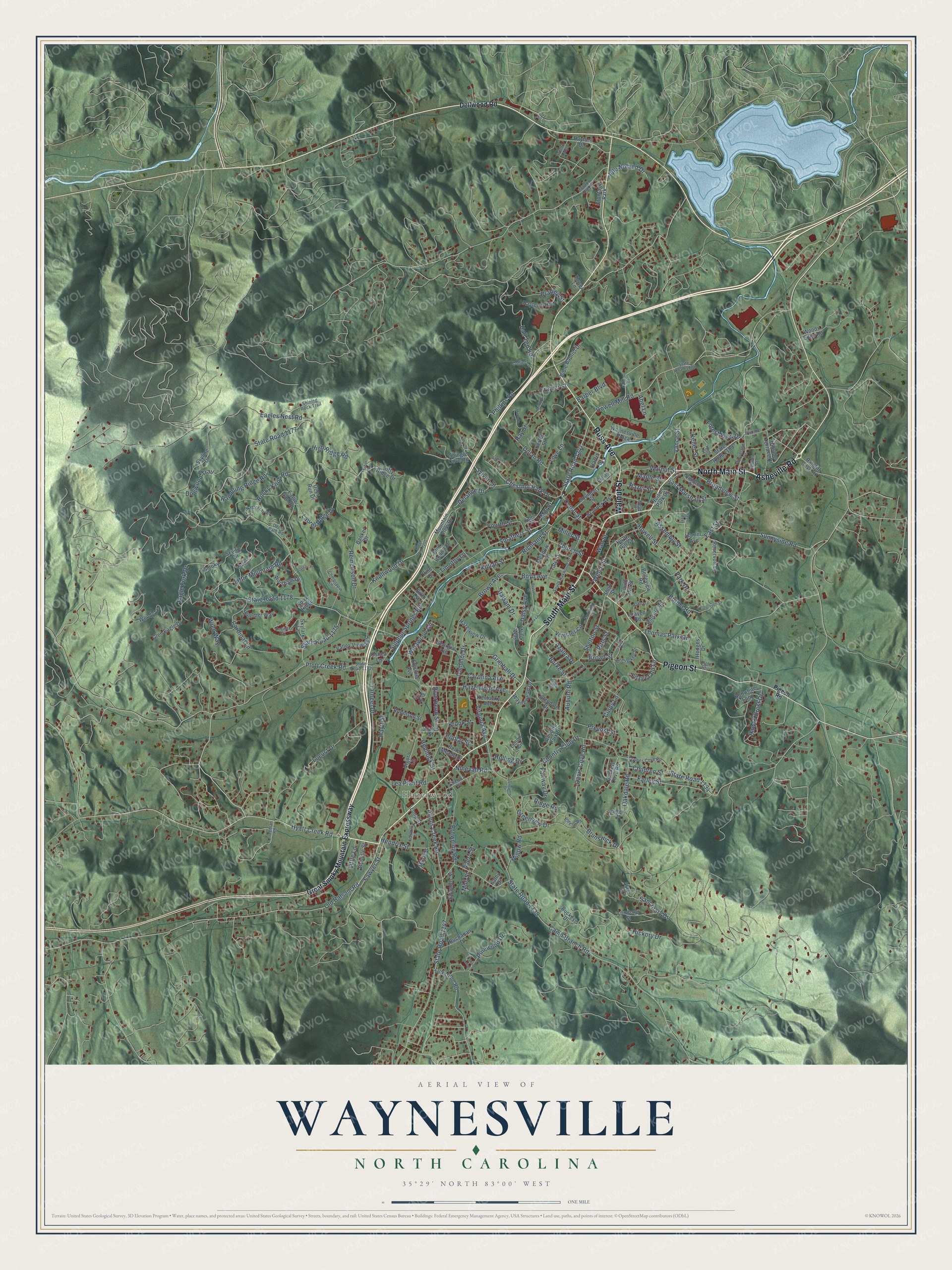
Building by building, with labeled streets and shaded relief.
12" x 18" Archival Matte Print
A Map of Home. A Work of Art.
Explore Waynesville, North Carolina from a whole new perspective. Created using aerial imagery and detailed geographic data, this map captures Waynesville building by building, with labeled streets, familiar landmarks, and shaded topographical relief that highlights the natural contours of the landscape.
Combining modern data with the timeless character of a vintage atlas, this map is just as interesting up close as it is beautiful on the wall. Whether you grew up in Waynesville, spent memorable years there, or call it home today, this unique map is a great way to celebrate a place that means something to you. Zoom in on the preview to look for your street, and then order a print to put your memories on the wall.
Three ways to hang it

Unframed archival matte, a black wood frame or a white wood frame.
Up close
Geography Worth Displaying
This map was created using accurate cartographic data and authoritative geographic sources, including the U.S. Geological Survey and the Census Bureau. The map brings together terrain, waterways, roads, and building detail. The majority of the streets are labeled, houses are accurately depicted, and the topography is derived from government sources. Combining local data with carefully composed color and shading leads to this beautifully detailed Waynesville artwork for your wall.
Rather than simply showing street outlines, we’ve included as many of the street names as we could reasonably fit on the map while keeping their names legible. Zoom in on the high resolution preview to see exactly what’s on the map. We truly set out to create a statement piece for anyone who loves Waynesville. So whether it’s for you, or a gift for someone you love, we hope this map of Waynesville brings back fond memories.
Read the story behind this map of Waynesville, North Carolina from 2026.

Find your street
Names on the Waynesville map
Every name below is printed on this map. Look for your street, your school, the park where you played, or the pond down the road.
Places and landmarks2
- Hazelwood
- Frontage Park
Streets and roads242
- South Main Street
- North Main Street
- Asheville Road
- Russ Avenue
- Pigeon Street
- Walnut Street
- Hyatt Creek Road
- Smathers Street
- Church Street
- Allens Creek Road
- State Road 1134
- Broadview Street
- State Road 1147
- Country Club Drive
- Plott Creek Road
- State Road 1177
- Eagles Nest Road
- Oakdale Road
- Brown Avenue
- East Street
- Camp Branch Road
- State Road 1138
- Rocky Knob Road
- Laurel Ridge Drive
- Little Mountain Road
- State Road 1178
- Dogwood Trail
- Sulphur Springs Road
- High Ridge Road
- Hazelwood Avenue
Show all 242 streets
- Locust Drive
- State Road 1247
- Pinewood Drive
- Hickory Drive
- Camelot Drive
- Howell Mill Road
- Knollwood Drive
- Greenview Drive
- Love Lane
- Auburn Road
- Westwood Circle
- Old Balsam Road
- Vance Street
- Wall Street
- East Marshall Street
- Balsam Drive
- Ray Street
- Reinertson Drive
- Hall Top Road
- Shelton Street
- Boyd Avenue
- Cardinal Lane
- Chestnut Park Drive
- Brunswick Drive
- Riverbend Street
- Tarheel Drive
- Rambling Ridge Road
- Haytt Street
- Killian Street
- Browning Road
- Grimball Drive
- Lea Plant Road
- Eagle Fork Drive
- Farley Street
- Fourth Street
- Fairway Drive
- Welch Street
- Sanctuary Drive
- Rolling Drive
- Wren Way
- Howell Street
- Thomas Park Drive
- State Road 1175
- Daisy Avenue
- Hawks Crest Drive
- Assembly Street
- Carolina Avenue
- Davis Cove Road
- Richland Street
- Dolan Road
- Ridge Road
- Hendrix Street
- Sylvan Street
- Virginia Avenue
- Burma Road
- Park Drive
- Hemlock Street
- Brook Street
- Depot Street
- Sawyer Street
- Willow Road
- Barber Boulevard
- Phillips Road
- Prevost Street
- Bradley Street
- Jule Noland Drive
- Miller Street
- Hazel Street
- Forest View Drive
- Children Street
- Mill Street
- Keller Street
- Ninevah Road
- Fitzgerald Lane
- Sunnyside Road
- Delanne Drive
- Frazier Street
- Timothy Lane
- Azalea Drive
- Maple Street
- Broad Street
- Burke Street
- Poplar Street
- Little Lane
- Pitts Street
- Cindy Lane
- Avery Street
- Abel Lane
- Mull Street
- Dellwood Road
- Great Smoky Mountain Expressway
- Harris Street
- Scenic Circle
- Woody Lane
- Auburn Park Drive
- Blink Bonny Drive
- Boundary Street
- Georgia Avenue
- Hamer Avenue
- Veterans Circle
- Mountain View Drive
- Skylark Lane
- Banker Drive
- Belleview Road
- Skyline Drive
- State Road 1189
- Lickstone Road
- Hodges Drive
- Lenoir Circle
- Meadow Street
- Glen Eagle Drive
- Valley View Terrace
- Bobwhite Loop
- North Hill Street
- Hillside Road
- Elysinia Avenue
- Reservoir Drive
- Eagle Gap Road
- Waynesville Plaza
- Duckett Cove Road
- Branner Avenue
- Raytown Heights
- Vigoro Lane
- Bible Baptist Drive
- Hillside Terrace Drive
- Belle Meade Drive
- Waynewood Drive
- South Hill Street
- Buchanan Drive
- Woods Edge Road
- Short Street
- Hazelview Drive
- Summer Way
- Tate Street
- Craven Road
- Robinson Street
- Long Street
- Edwards Street
- Worsham Drive
- Lombard Street
- Muse Street
- Kentucky Avenue
- Lofty Ridge Drive
- Brendle Street
- Nelson Park Drive
- Giles Place
- Ratcliff Cove Road
- Glendale Drive
- Smoky Lane
- Dayton Drive
- Buckeye Drive
- Kerley Street
- Shingle Cove Road
- Scates Street
- Deer Run Drive
- Oshea Lane
- Sixth Street
- Wills Way
- Spice Ridge
- Tower Lane
- Kathy Drive
- Aster Lane
- Pine Drive
- Pigeon Road
- Crymes Cove Road
- State Road 1184
- State Road 1173
- Deer Path Road
- Highland Road
- Woodland Drive
- South Haywood Street
- Chinquapin Lane
- Chelsea Road
- McCracken Street
- Morning Drive
- Nags Trail Road
- Norris Street
- High Street
- Shining Rock Trail
- Buffalo Lane
- Sutton Loop
- Baldwin Drive
- Estero Road
- Collier Lane
- Freeman Road
- Felmet Street
- Plott Heights
- Mead Street
- State Road 1244
- Longview Drive
- Bryson Street
- Joy Lane
- Augusta Circle
- Calhoun Road
- Anthony Street
- Yarborough Street
- Layfield Drive
- Melinda Drive
- Mauney Cove Road
- Grayden Street
- Lariat Loop
- Babb Street
- McElroy Street
- Franklin Street
- Lowell Street
- Plateau Place
- Taylor Avenue
- Ivy Hill Drive
- Fairlane Drive
- Lansing Road
- Arbor Drive
- Kelley Street
Names are listed as they appear on the printed map. Zoom into the product photos to find them.
About Waynesville, North Carolina
From the A History of Haywood County: "One of the most beautiful churches in Western North Carolina has recently been completed in Waynesville by the Methodists, and the same denomination constructed the Junaluska Methodist Church at Lake Junaluska."
Keep exploring North Carolina
Waynesville is one of 952 North Carolina towns we've mapped. Every dot on the map is a print of its own.
The search covers every state, North Carolina first.
Near Waynesville
Order 2 or more town maps and save 10%. Shown in the size and finish you picked above, so they hang as a set.
- Lake Junaluska 12" x 18" / Archival Matte Print $39.99
- Maggie Valley 12" x 18" / Archival Matte Print $39.99
- Bethel 12" x 18" / Archival Matte Print $39.99


More maps nearby: Clyde, West Canton, Canton, Jonathan and Sylva.
The art of mapping a place
How This Map Was Made
Real places. Remarkable detail. Discover the layers that turn geographic data into a map of home.

The view from above
Aerial imagery reveals the character of the land: woodland, open fields, and the patterns of a place.

The shape of the land
Elevation data brings hills, valleys, and subtle changes in the landscape into view.

The details of home
Roads, waterways, and building footprints come together to make the map feel unmistakably local.

Geography becomes art
Considered color, shading, and typography bring the layers together in a map made for your wall.


Process illustrated with Mendon, Massachusetts. Aerial imagery: USDA NAIP. Terrain: USGS 3D Elevation Program. Map details and finished artwork: KNOWOL.
The Details
About This Print
Choose an archival matte print, or a black or white Ayous wood frame. The archival matte print is unframed.
Select your size and finish above to see the matching product image and price.
Materials & Craftsmanship
A contemporary map with the character of a classic atlas, printed on archival matte paper. Optional frames are made from Ayous wood.
Your printed map does not include the watermark shown in the full-map preview.
Shipping & Delivery
Free shipping within the United States. Every print is made to order in the USA.
Buying a gift? Add a note in your cart and we'll include it. We never put prices in the package.
Prints ship within 2 to 3 business days. Allow 7 to 10 days total from ordering for delivery. Timing may vary during holidays or periods of high order volume.
Read our shipping policy.
Returns and damaged prints
Each print is made to order. Change-of-mind refunds are not available after production.
If your print arrives damaged, misprinted or incorrect, contact support@knowol.com within 30 days of receiving it. Include your order number, photos and a description of the issue.
Read our full refund and replacement policy. For questions about your order, email support@knowol.com.