
Search for another town


Free U.S. delivery 7 to 10 days after you order
Lake Junaluska, North Carolina Map Art
Building by building, with labeled streets and shaded relief.
12" x 18" Archival Matte Print
A Map of Home. A Work of Art.
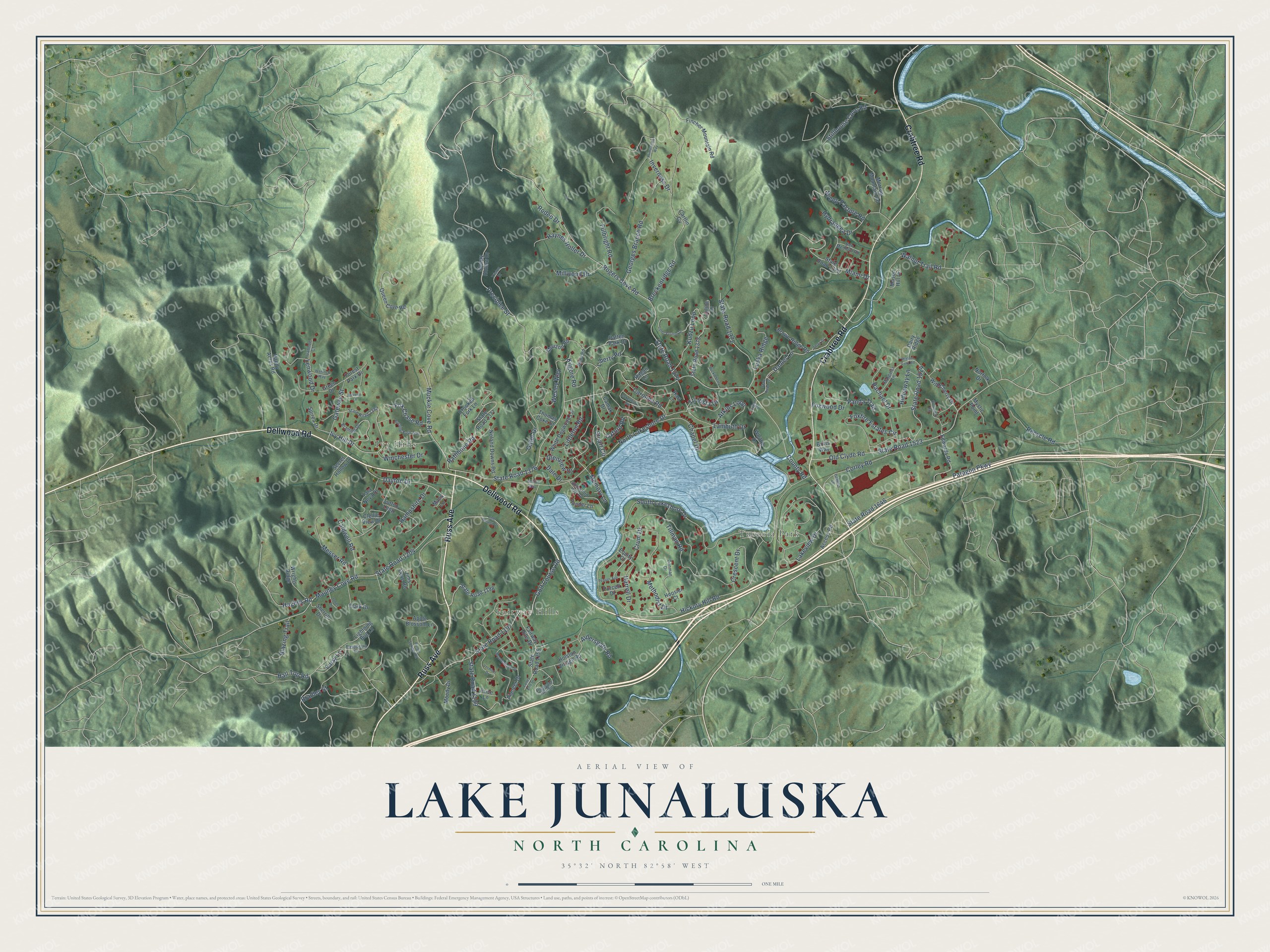
Explore Lake Junaluska, North Carolina from a whole new perspective. Created using aerial imagery and detailed geographic data, this map captures Lake Junaluska building by building, with labeled streets, familiar landmarks, and shaded topographical relief that highlights the natural contours of the landscape.
Combining modern data with the timeless character of a vintage atlas, this map is just as interesting up close as it is beautiful on the wall. Whether you grew up in Lake Junaluska, spent memorable years there, or call it home today, this unique map is a great way to celebrate a place that means something to you. Zoom in on the preview to look for your street, and then order a print to put your memories on the wall.
Three ways to hang it

Unframed archival matte, a black wood frame or a white wood frame.
Up close
Geography Worth Displaying
This map was created using accurate cartographic data and authoritative geographic sources, including the U.S. Geological Survey and the Census Bureau. The map brings together terrain, waterways, roads, and building detail. The majority of the streets are labeled, houses are accurately depicted, and the topography is derived from government sources. Combining local data with carefully composed color and shading leads to this beautifully detailed Lake Junaluska artwork for your wall.
Rather than simply showing street outlines, we’ve included as many of the street names as we could reasonably fit on the map while keeping their names legible. Zoom in on the high resolution preview to see exactly what’s on the map. We truly set out to create a statement piece for anyone who loves Lake Junaluska. So whether it’s for you, or a gift for someone you love, we hope this map of Lake Junaluska brings back fond memories.
Read the story behind this map of Lake Junaluska, North Carolina from 2026.

Find your street
Names on the Lake Junaluska map
Every name below is printed on this map. Look for your street, your school, the park where you played, or the pond down the road.
Places and landmarks3
- Ivy Hills
- Fairway Hills
- Tuscola Park
Streets and roads168
- Dellwood Road
- Russ Avenue
- Crabtree Road
- County Road
- State Road 1376
- South Lakeshore Drive
- North Lakeshore Drive
- Rogers Cove Road
- State Road 1374
- Paragon Parkway
- State Road 1646
- Old Clyde Road
- State Road 1523
- Mauney Cove Road
- State Road 1204
- Golf Course Road
- State Road 1197
- Stillhouse Cove Road
- Breckenridge Road
- Hickory Hill Road
- Miami Drive
- Ivy Hill Drive
- Kudzu Loop
- Oxford Road
- Crum Drive
- Walnut Trail Road
- Foxfire Estates Circle
- Kilgore Road
- Lakeview Drive
- Daniel Lane
Show all 168 streets
- Muckle Cove Road
- State Road 1524
- State Road 1372
- Tillman Road
- Precipice Street
- Littleton Road
- Methodist Drive
- Dayton Drive
- Sheep Pasture Road
- Inverness Drive
- Rachael Drive
- Liberty Road
- Fulbright Road
- Crescent Drive
- Corley Road
- Messer Road
- State Road 1199
- Lenwood Drive
- Lambuth Drive
- Hall Top Road
- Georges Branch Road
- Wesley Way
- Stuart Circle
- Atkins Loop
- Haynes Holler Drive
- Hideaway Lane
- Gateway Street
- Chapel Drive
- Fox Chase Road
- Caldwell Road
- Recycle Road
- Carolina Road
- Hydrangea Drive
- Harrell Drive
- Millwood Drive
- Glenview Drive
- Rodeo Drive
- Winchester Drive
- Hampshire Drive
- Bradley Street
- Luska Ridge
- Blazing Trail
- Dale Drive
- Tri Vista Drive
- Aldersgate Road
- Foxwood Drive
- Rathbone Road
- Memory Lane
- Hughes Road
- Gator Drive
- Furry Lane
- Panda Trail
- Sleepy Hollow Drive
- Access Road
- State Road 1370
- Queen Cove Road
- State Road 1373
- Holston Village Road
- State Road 1377
- Pioneer Drive
- Mouzon Road
- Fincher Mountain Road
- Fairway Hills Drive
- State Road 1255
- Lightning Bug Lane
- Morrow Mountain Road
- Tara Nova Drive
- Apple Blossom Lane
- State Road 1198
- Happy Acres Road
- White Dogwood Lane
- Green Drive
- Edwards Road
- Noland Downs Road
- Sutton Loop
- Clellie View Drive
- Wrights Ridge
- Wild Cherry Drive
- Clark Drive
- Crooked Fork Lane
- Moody Drive
- Brown Ridge Road
- Spirea Drive
- Secret Hollow Lane
- Ponder Lane
- Whittle Drive
- Patten Park Drive
- Mason Hill Drive
- Jims Cove Road
- Caline Drive
- Hoosier Court
- Sherrill Drive
- Forest Park Drive
- Purcell Drive
- Mystic Point
- Dairy Ridge
- Cartlin Cv
- Thomas Coke Drive
- Norfolk Drive
- Camak Drive
- Price Lane
- Britts Way
- Macs Lane
- Ragan Lane
- Equity Court
- Hart Lane
- State Road 1392
- Bramlett Drive
- Shackford Hall Road
- Pleasant Hill Circle
- Ben Medford Road
- Denman Drive
- Raspberry Lane
- Margaret Lane
- Wells Road
- Ivanhoe Court
- State Road 1371
- Walnut Ford Road
- Cokesbury Circle
- Triston Drive
- Burgin Springs Road
- Irene Vernon Drive
- Rimesdale Way
- Vermont Drive
- Weldon Way
- Cloverhill Road
- Burning Bush Trail
- Mountaineer Drive
- Pepper Avenue
- Huckleberry Lane
- Beverly Lane
- Jule Noland Drive
- Wenlock Way
- Jones Drive
- Phlox Drive
- Lanes End Drive
- Islander Lane
- Logan Drive
Names are listed as they appear on the printed map. Zoom into the product photos to find them.
About Lake Junaluska, North Carolina
Lake Junaluska is a community of 3,219 people in Haywood County, beside a 200-acre lake made by damming Richland Creek. In April 1908 the Methodist pastor James Atkins reached out to George R. Stuart, a pastor in Chattanooga. Both men believed the Southeast needed a church assembly ground like those at Chautauqua Lake, New York, and Winona Lake, Indiana. The Southern Assembly, Inc. then bought 1,200 acres in the Haywood County mountains, and the dam went up between 1911 and 1913.
On June 25, 1913, the Methodist Episcopal Church, South opened its Second General Missionary Conference in a new auditorium named for Stuart. The lake was still filling, and some visitors crossed its dry bed, where farmers were bringing in corn. Only 13 houses stood here and there was no hotel yet, so the 4,000 people who came had to sleep elsewhere. The assembly grew anyway, and in 1952 the World Methodist Council chose Lake Junaluska for its American headquarters.
- Named for a Cherokee leaderThe lake takes its name from Junaluska, a Cherokee chief. Wikipedia traces the name through nearby Mount Junaluska, now called North Eaglenest Mountain. The water covers the site of Tuscola, an older community that had its own post office in the 1870s and 1880s.
- Hotels that kept burningThe first hotel, the Auditorium Hotel, opened across from Stuart Auditorium in 1914 and burned in 1920. The Junaluska Inn, built in 1917, burned the following year. A new hotel went up on the same site in 1921 and was later named for Bishop Walter Russell Lambuth. It was enlarged in 1956 and 1964, and it is on the National Register as the Lambeth Inn.
- Shackford Hall, 1923In 1923 the assembly built Shackford Hall, a classroom building at the lake's west end. Like the hotel, it is listed on the National Register.
- A lighted cross since 1922In 1922 a large lighted cross went up on a spot overlooking the lake near the old hotel. A new cross replaced it in 1994, and the original was restored and moved to Mount Shepherd Retreat Center near Asheboro.
- The Warren CenterThe World Methodist Council's headquarters building and museum changed hands in spring 2021, when the assembly paid the council $1.25 million for them. The council moved its offices to Waynesville, and Southern Methodist University took the museum's collection. Mike and Anne Warren gave $625,000 toward the purchase, so the building was renamed the Warren Center in their honor, and it held its first event in June 2024.
Keep exploring North Carolina
Lake Junaluska is one of 952 North Carolina towns we've mapped. Every dot on the map is a print of its own.
The search covers every state, North Carolina first.
Near Lake Junaluska
Order 2 or more town maps and save 10%. Shown in the size and finish you picked above, so they hang as a set.
- Waynesville 12" x 18" / Archival Matte Print $39.99
- Clyde 12" x 18" / Archival Matte Print $39.99
- Maggie Valley 12" x 18" / Archival Matte Print $39.99


More maps nearby: Bethel, West Canton, Canton, Jonathan and Candler.
The art of mapping a place
How This Map Was Made
Real places. Remarkable detail. Discover the layers that turn geographic data into a map of home.

The view from above
Aerial imagery reveals the character of the land: woodland, open fields, and the patterns of a place.

The shape of the land
Elevation data brings hills, valleys, and subtle changes in the landscape into view.

The details of home
Roads, waterways, and building footprints come together to make the map feel unmistakably local.

Geography becomes art
Considered color, shading, and typography bring the layers together in a map made for your wall.


Process illustrated with Mendon, Massachusetts. Aerial imagery: USDA NAIP. Terrain: USGS 3D Elevation Program. Map details and finished artwork: KNOWOL.
The Details
About This Print
Choose an archival matte print, or a black or white Ayous wood frame. The archival matte print is unframed.
Select your size and finish above to see the matching product image and price.
Materials & Craftsmanship
A contemporary map with the character of a classic atlas, printed on archival matte paper. Optional frames are made from Ayous wood.
Your printed map does not include the watermark shown in the full-map preview.
Shipping & Delivery
Free shipping within the United States. Every print is made to order in the USA.
Buying a gift? Add a note in your cart and we'll include it. We never put prices in the package.
Prints ship within 2 to 3 business days. Allow 7 to 10 days total from ordering for delivery. Timing may vary during holidays or periods of high order volume.
Read our shipping policy.
Returns and damaged prints
Each print is made to order. Change-of-mind refunds are not available after production.
If your print arrives damaged, misprinted or incorrect, contact support@knowol.com within 30 days of receiving it. Include your order number, photos and a description of the issue.
Read our full refund and replacement policy. For questions about your order, email support@knowol.com.