
Search for another town


Free U.S. delivery 7 to 10 days after you order
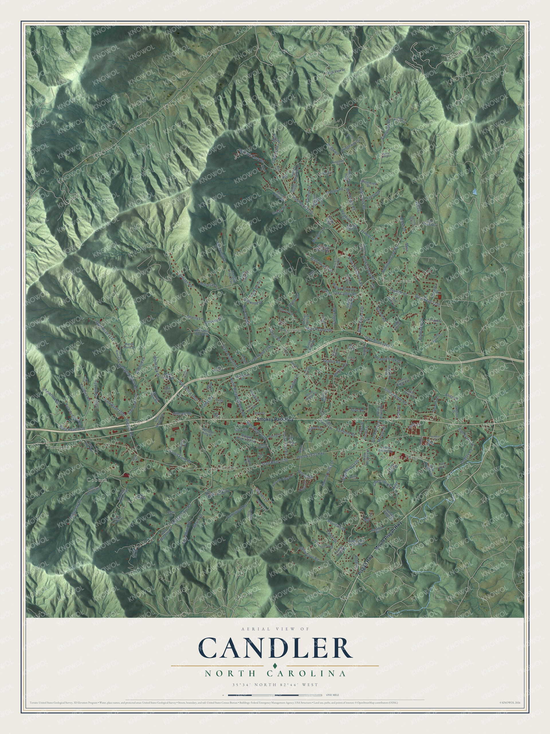
Candler, North Carolina Map Art
Building by building, with labeled streets and shaded relief.
12" x 18" Archival Matte Print
A Map of Home. A Work of Art.
Explore Candler, North Carolina from a whole new perspective. Created using aerial imagery and detailed geographic data, this map captures Candler building by building, with labeled streets, familiar landmarks, and shaded topographical relief that highlights the natural contours of the landscape.
Combining modern data with the timeless character of a vintage atlas, this map is just as interesting up close as it is beautiful on the wall. Whether you grew up in Candler, spent memorable years there, or call it home today, this unique map is a great way to celebrate a place that means something to you. Zoom in on the preview to look for your street, and then order a print to put your memories on the wall.
Three ways to hang it

Unframed archival matte, a black wood frame or a white wood frame.
Up close
Geography Worth Displaying
This map was created using accurate cartographic data and authoritative geographic sources, including the U.S. Geological Survey and the Census Bureau. The map brings together terrain, waterways, roads, and building detail. The majority of the streets are labeled, houses are accurately depicted, and the topography is derived from government sources. Combining local data with carefully composed color and shading leads to this beautifully detailed Candler artwork for your wall.
Rather than simply showing street outlines, we’ve included as many of the street names as we could reasonably fit on the map while keeping their names legible. Zoom in on the high resolution preview to see exactly what’s on the map. We truly set out to create a statement piece for anyone who loves Candler. So whether it’s for you, or a gift for someone you love, we hope this map of Candler brings back fond memories.
Read the story behind this map: Detailed Map of Candler, North Carolina.

Find your street
Names on the Candler map
Every name below is printed on this map. Look for your street, your school, the park where you played, or the pond down the road.
Places and landmarks6
- Turnpike
- Candler Heights
- Coburn
- Pole Creek
- Jugtown
- Luther
Streets and roads219
- Smokey Park Highway
- Mount Pisgah Highway
- Pisgah Highway
- Pole Creek Road
- State Road 1220
- Hookers Gap Road
- State Road 1210
- Morgan Cove Road
- Fairmont Road
- Snow Hill Church Road
- Morgan Road
- State Road 1205
- Ashbrook Drive
- State Road 1438
- Ross Mintz Road
- Wiggins Road
- State Road 1120
- Ridgeway Road
- Welch Road
- Grooms Road
- Old US 19 23 Highway
- State Road 1130
- Justice Ridge Road
- State Road 1208
- State Road 1215
- Big Cove Road
- State Road 1207
- Luther Road
- State Road 1141
- Milksick Cove Road
Show all 219 streets
- State Road 1200
- Bryson Road
- State Road 1212
- North Morgan Branch Road
- Ben Wright Road
- Ridge Road
- Robinson Cove Road
- State Road 1140
- Cathey Road
- Bradshaw Circle
- Lindsey Road
- Homewood Road
- Hominy Valley Drive
- Shanes Lane
- Georges Branch Road
- Vintage Road
- Poplar Cove Road
- Mountain Drive
- Hillcrest Drive
- State Road 1131
- Young Drive
- Bridgeway Drive
- Charity Lane
- Bentwood Drive
- Childers Road
- English Road
- Colebrook Road
- Curtis Farm Road
- Meadowbrook Drive
- Harkins Cove Road
- Anita Lane
- Wildbird Lane
- Willow Bend Drive
- Cole Cove Road
- Indian Trail Road
- Fox Hill Drive
- Hurst Drive
- Stillwood Drive
- Wilson Road
- Old Cathey Road
- State Road 1445
- Carolyn Drive
- Poplar Drive
- Old Tull Road
- White Oak Drive
- Stamey Road
- Ginger Lane
- Ashe Road
- Morgan Street
- Lively Lane
- Mieko Drive
- Monarch Drive
- Corvette Drive
- Dixon Terrace
- Parker Drive
- Meadow Lane
- Cross Street
- Mimi Lane
- Dogwood Road
- Candler School Road
- State Road 1126
- State Road 1135
- Youngs Cove Road
- Cold Mountain Drive
- Walking Horse Trail
- North Luther Road
- Hidden Meadows Drive
- State Road 1465
- State Road 1289
- State Road 1221
- State Road 1128
- Morgan Branch Estate
- State Road 1437
- Forrest Lane
- State Road 1204
- Holland Ridge Road
- Indian Branch Road
- Grassy View Road
- Pine Tree Drive
- Foxbriar Drive
- Laurel Knoll
- Junction Drive
- Challedon Drive
- Hillside Ridge Road
- State Road 1461
- Paradise Court
- Creek Run Road
- Harris Ridge Road
- Green Acres Drive
- Winding Spring Road
- Justice Ridge Terrace
- State Road 1134
- Wild Rose Lane
- Dogwood Ridge
- Williams Way West
- Manor Stone Drive
- Gossett Street
- Briggs Drive
- Travis Cove Road
- Fowler Town Road
- Stone Ridge Drive
- Bachelder Lane
- McFalls Road
- Miller Road
- High View Drive
- Spencer Road
- Wintercrest Drive
- Cleve Street
- Talon Rest Drive
- Isaac Hill
- Brown Road
- Burrece Drive
- Ridge View Acres Road
- State Road 1137
- Pinnacle Pine Trail
- Greene View Road
- Haly Ho Drive
- Dusty Lane
- Spring Street
- Brendell Road
- Phillips Dairy Drive
- Macie Lane
- Fair Drive
- Gray Dove Road
- Country Lane
- Lauren Lane
- Donna Road
- Hinson Drive
- Herschel King Drive
- East Forest Place
- Smoke Ridge
- Brooms Road
- Midge Lane
- Apple Lane
- Odie Lane
- Jared Court
- Joy Lane
- Ola Drive
- Milk Sick Cove Road
- Horn Cove Road
- State Road 1225
- Ridgedale Road
- State Road 1295
- George Branch Road
- Paradise Ridge Road
- Jones Stamey Road
- Rising Sun Road
- Old Youngs Cove Road
- Dragons Dale Drive
- Aloha Circle
- Turning Leaf Lane
- Happy Hollow Drive
- Fieldcrest Road
- Western Haze Trail
- Griffin Lane
- English Oaks Drive
- Dots Drive
- Emily Ridge Road
- Center Street
- Jonquil Lane
- Leelee Lane
- Shope Road
- Kaye Court
- State Road 1469
- Ridgedale Tp
- State Road 1209
- Howling Waite Ridge
- Hooker's Gap Road
- Serenity Mountain Drive
- Surrett Road
- August Lane
- Twin Acres Drive
- Hazelwood Hill Drive
- Venetian Drive
- Rainbow Lane
- Doyce Drive
- Goodson Hill Road
- Molly Lane
- Lockes Lane
- Rory Phillips Vw
- Hemlock Court
- Lost Trail Drive
- White Terrace
- Conrad Drive
- Emmaus Fields Lane
- Kilby Trail
- Baylie Grace Lane
- Gerald's Lane
- Sunrise Lane
Names are listed as they appear on the printed map. Zoom into the product photos to find them.
About Candler, North Carolina
Candler takes its name from George Candler, one of the first settlers in the Hominy Valley. In the 1890s Russell Jones Gaston ran a big store and a mill on Hominy Creek here. Candler grew into a mill town, and by the early 1940s it had its own high school.
Keep exploring North Carolina
Candler is one of 952 North Carolina towns we've mapped. Every dot on the map is a print of its own.
The search covers every state, North Carolina first.
Near Candler
Order 2 or more town maps and save 10%. Shown in the size and finish you picked above, so they hang as a set.
- Hominy 12" x 18" / Archival Matte Print $39.99
- Canton 12" x 18" / Archival Matte Print $39.99
- Leicester 12" x 18" / Archival Matte Print $39.99


More maps nearby: Bent Creek, West Canton, Emma, Asheville and Woodfin.
The art of mapping a place
How This Map Was Made
Real places. Remarkable detail. Discover the layers that turn geographic data into a map of home.

The view from above
Aerial imagery reveals the character of the land: woodland, open fields, and the patterns of a place.

The shape of the land
Elevation data brings hills, valleys, and subtle changes in the landscape into view.

The details of home
Roads, waterways, and building footprints come together to make the map feel unmistakably local.

Geography becomes art
Considered color, shading, and typography bring the layers together in a map made for your wall.


Process illustrated with Mendon, Massachusetts. Aerial imagery: USDA NAIP. Terrain: USGS 3D Elevation Program. Map details and finished artwork: KNOWOL.
The Details
About This Print
Choose an archival matte print, or a black or white Ayous wood frame. The archival matte print is unframed.
Select your size and finish above to see the matching product image and price.
Materials & Craftsmanship
A contemporary map with the character of a classic atlas, printed on archival matte paper. Optional frames are made from Ayous wood.
Your printed map does not include the watermark shown in the full-map preview.
Shipping & Delivery
Free shipping within the United States. Every print is made to order in the USA.
Buying a gift? Add a note in your cart and we'll include it. We never put prices in the package.
Prints ship within 2 to 3 business days. Allow 7 to 10 days total from ordering for delivery. Timing may vary during holidays or periods of high order volume.
Read our shipping policy.
Returns and damaged prints
Each print is made to order. Change-of-mind refunds are not available after production.
If your print arrives damaged, misprinted or incorrect, contact support@knowol.com within 30 days of receiving it. Include your order number, photos and a description of the issue.
Read our full refund and replacement policy. For questions about your order, email support@knowol.com.