


Search for another town


Free U.S. delivery 7 to 10 days after you order
Asheville, North Carolina Map Art
Building by building, with labeled streets and shaded relief.
12" x 18" Archival Matte Print
A Map of Home. A Work of Art.
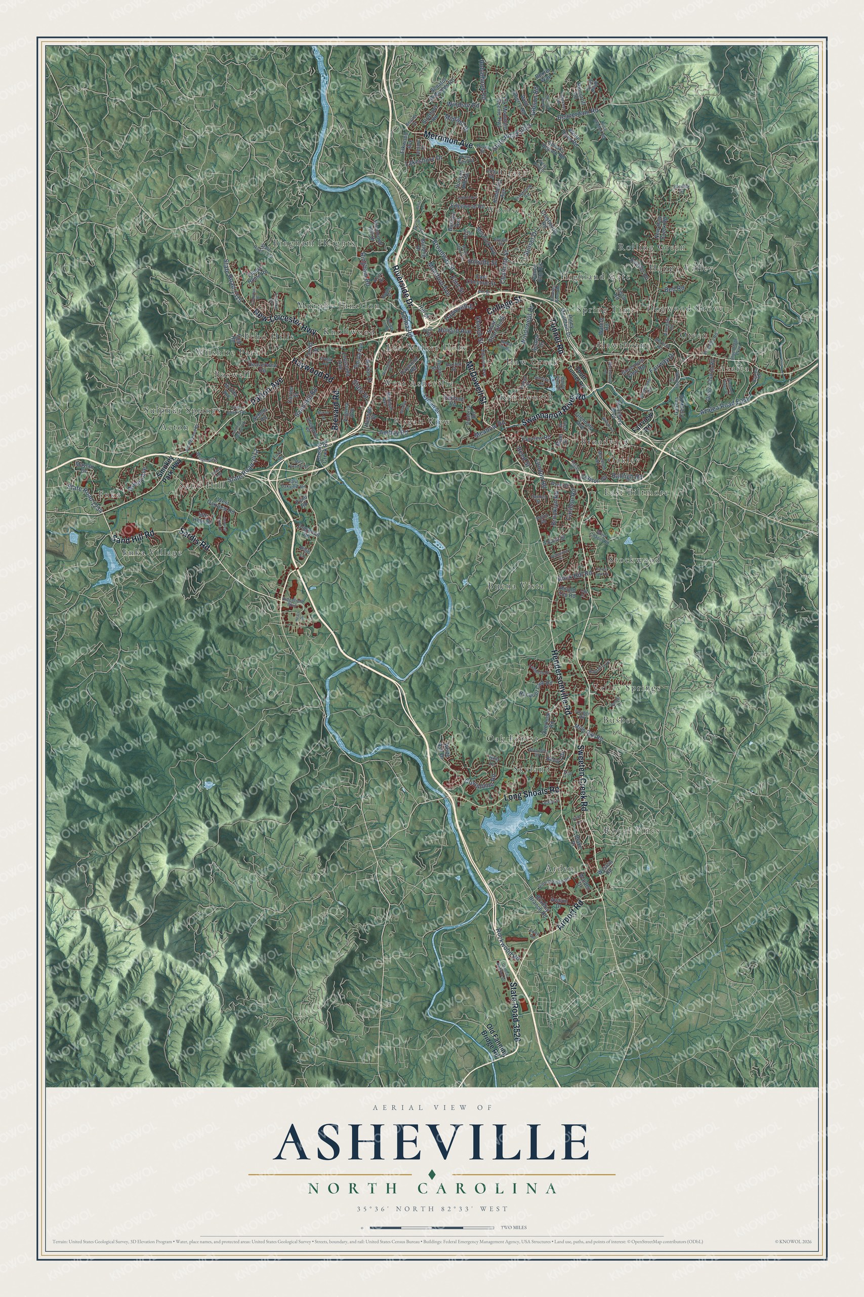
Explore Asheville, North Carolina from a whole new perspective. Created using aerial imagery and detailed geographic data, this map captures Asheville building by building, with labeled streets, familiar landmarks, and shaded topographical relief that highlights the natural contours of the landscape.
Combining modern data with the timeless character of a vintage atlas, this map is just as interesting up close as it is beautiful on the wall. Whether you grew up in Asheville, spent memorable years there, or call it home today, this unique map is a great way to celebrate a place that means something to you. Zoom in on the preview to look for your street, and then order a print to put your memories on the wall.
Three ways to hang it

Unframed archival matte, a black wood frame or a white wood frame.
Up close
Geography Worth Displaying
This map was created using accurate cartographic data and authoritative geographic sources, including the U.S. Geological Survey and the Census Bureau. The map brings together terrain, waterways, roads, and building detail. The majority of the streets are labeled, houses are accurately depicted, and the topography is derived from government sources. Combining local data with carefully composed color and shading leads to this beautifully detailed Asheville artwork for your wall.
Rather than simply showing street outlines, we’ve included as many of the street names as we could reasonably fit on the map while keeping their names legible. Zoom in on the high resolution preview to see exactly what’s on the map. We truly set out to create a statement piece for anyone who loves Asheville. So whether it’s for you, or a gift for someone you love, we hope this map of Asheville brings back fond memories.
Read the story behind this map of Asheville, North Carolina from 2026.

Find your street
Names on the Asheville map
Every name below is printed on this map. Look for your street, your school, the park where you played, or the pond down the road.
Places and landmarks37
- Arden
- Acton
- Buena Vista
- Rolling Green
- East Biltmore
- Busbee
- Azalea
- Grace
- Spring Time
- Pisgah View
- Enka Village
- Murphy Junction
Show all 37 places
- Broadview
- Skyland
- Kenilworth
- Wilshire Park
- Bingham Heights
- Valley Springs
- Oteen
- Knollwood
- Royal Pines
- Highland Gate
- Stockwood
- West Asheville
- Enka
- Happy Valley
- Oakley
- Sand Hill
- Woolsey
- Lee Walker Hots
- Sulphur Springs
- Dogwood Grove
- Boswell
- Haw Creek
- Echo Hills
- Hawthorne
- Oak Forest
Streets and roads209
- Sweeten Creek Road
- Patton Avenue
- Merrimon Avenue
- State Road 3526
- Airport Road
- Haywood Road
- McDowell Street
- Sand Hill Road
- College Street
- Sardis Road
- Hendersonville Road
- Tunnel Road
- Brevard Road
- Swannanoa River Road
- New Leicester Highway
- Long Shoals Road
- Riverside Drive
- State Road 1234
- Charlotte Street
- State Road 3412
- Broadway Street
- Beaverdam Road
- State Road 2053
- Sunset Drive
- Azalea Road East
- Caribou Road
- Windsor Road
- Robinhood Road
- Fairway Drive
- Lakeshore Drive
Show all 209 streets
- Meadow Road
- State Road 1315
- Amboy Road
- State Street
- Montford Avenue
- Reed Street
- Rock Hill Road
- London Road
- Midland Drive
- Windswept Drive
- Bingham Road
- Emma Road
- Brooklyn Road
- Haywood Street
- Hillside Street
- Hilliard Avenue
- Columbine Road
- Bell Road
- Rockwood Road
- Flint Street
- Moody Avenue
- Gibson Road
- Raleigh Road
- Church Street
- Old Fanning Bridge Road
- Smokey Park Highway
- Fairview Road
- South Charlotte Street
- Bradley Branch Road
- Deaverview Road
- School Road
- New Haw Creek Road
- Overlook Road
- Governors View Road
- Kimberly Avenue
- Edgewood Road
- Lyman Street
- Stratford Road
- Bleachery Boulevard
- Gashes Creek Road
- Elk Mountain Scenic Highway
- Piney Mountain Drive
- Victoria Road
- Hominy Creek Road
- Richmond Hill Drive
- Hill Street
- White Ash Drive
- Aurora Drive
- Cisco Road
- Virginia Avenue
- Hi Alta Avenue
- Spooks Branch Road
- Racquet Club Road
- Glendale Avenue
- Barnard Avenue
- Mills Gap Road
- Depot Street
- West Oakview Road
- Oteen Church Road
- Eliada Home Road
- Senator Reynolds Road
- East Chestnut Street
- Elkwood Avenue
- Murdock Avenue
- Mayfair Drive
- Hanover Street
- Blake Drive
- Crestwood Road
- Wolfe Cove Road
- Dogwood Road
- Louisiana Avenue
- Horizon Hill Road
- Burton Street
- Avalon Drive
- Pond Road
- Pinecroft Road
- Druid Drive
- Wild Cherry Road
- Waters Road
- Vance Gap Road
- Crayton Road
- Florida Avenue
- Oakland Road
- Cub Road
- Carrier Street
- Round Top Road
- Keasler Road
- Bevlyn Drive
- Weston Road
- Bulldog Drive
- Dexter Way
- Idle Hour Drive
- Forest Street
- Walden Drive
- Pine Lane
- Main Street
- Holt Lane
- South Tunnel Road
- Biltmore Avenue
- Ridgefield Boulevard
- Loop Road
- Blue Ridge Parkway
- West Chapel Road
- State Road 1338
- Beverly Road
- Stony Ridge
- Chunns Cove Road
- Glenn Bridge Road
- White Pine Drive
- Michigan Avenue
- Shelburne Road
- Azalea Road
- Lambeth Drive
- Sondley Drive
- Shiloh Road
- Wyatt Street
- Merchant Street
- East Oakview Road
- Beaver Drive
- Keith Drive
- Rice Branch Road
- Faircrest Road
- Evelake Drive
- Bartlett Street
- Riceville Road
- Innsbrook Road
- Gladstone Road
- Pine Tree Road
- Stancliff Drive
- Evelyn Place
- Pinedale Road
- Gerber Road
- Alclare Drive
- Dover Street
- Lee Street
- Ottari Road
- Waverly Court
- Center Street
- First Street
- Dalton Street
- Boone Street
- King Street
- Club Street
- Fury Drive
- Birch Lane
- Old Haywood Road
- State Road 1404
- State Road 3413
- Ballantree Drive
- Asheville School Road
- Forest Lake Drive
- Westwood Place
- General Aviation Drive
- Carter Cove Road
- Mount Clare Avenue
- Pleasant Ridge Drive
- Beechwood Road
- Wood Avenue
- Montgomery Street
- Crowell Farms Drive
- Grove Cove Drive
- Compton Drive
- Fenner Avenue
- Retreat Hill Way
- Holiday Inn Drive
- Deanwood Circle
- Selwyn Road
- Bradley Street
- Division Street
- Atkins Street
- Craggy Avenue
- Barrett Lane
- Morris Street
- Sheridan Road
- Elm Street
- Raglee Drive
- Heart Drive
- Relic Lane
- Oak Place
Names are listed as they appear on the printed map. Zoom into the product photos to find them.
About Asheville, North Carolina
Asheville is a city of 94,589 people and the seat of Buncombe County, where the French Broad and Swannanoa rivers meet. The Cherokee used the ground at the meeting of the rivers for hunting and gatherings, and they called it Tokiyasdi, meaning "Where they race." White settlers began arriving in 1784, after the Revolution. Buncombe County was formed in 1792, and its seat was laid out as Morristown the next year on high ground where two Indian trails met. In 1797 the town was incorporated and renamed Asheville for Governor Samuel Ashe.
The Western North Carolina Railroad finished its line from Salisbury on October 3, 1880, and it was the first railroad to reach the city. Textile mills and other factories followed, and by 1900 Asheville was the third-largest city in North Carolina. Then the Great Depression struck. Eight local banks failed on November 20, 1930, and the city carried the highest debt per person in the nation. Asheville paid off its bonds over fifty years instead of defaulting. Because so little was rebuilt in those lean years, its downtown kept one of the country's finest groups of Art Deco buildings.
- The Battle of Asheville, 1865Fighting came to Asheville only in early April 1865, on the ground where the University of North Carolina at Asheville stands today. Old and young Confederate reserves, joined by recovering soldiers, held trenches across the Buncombe Turnpike, and the Union force pulled back to Tennessee. Later that month Union troops of the 3rd North Carolina Mounted Infantry, under Gen. George Stoneman, took the town. When the 2,700 men left, hundreds of freed slaves went with them.
- George Avery's cemeteryGeorge Avery was one of 40 enslaved people known to have left with the Union troops for Tennessee, where he joined the U.S. Colored Troops. Discharged in 1866, he returned to Asheville, and his former enslaver, William W. McDowell, hired him to run the South Asheville Cemetery, a public burial ground for Black residents. By its last burial in 1943 it held an estimated 2,000 people. It is North Carolina's oldest and largest such cemetery.
- The state's first streetcarsAsheville opened the first electric street railway line in North Carolina in 1889. The streetcars kept running until 1934, when buses took their place.
- Burton Street and West AshevilleIn the 1910s and 1920s, Rutherford P. Hayes, a son of President Rutherford B. Hayes, bought land here. He worked with Edward W. Pearson Sr., a leading African-American businessman, to build the homes that became the Burton Street Community. Hayes also pushed for a sanitary district in West Asheville, which became a town in 1913 and joined Asheville in 1917.
Keep exploring North Carolina
Asheville is one of 952 North Carolina towns we've mapped. Every dot on the map is a print of its own.
The search covers every state, North Carolina first.
Near Asheville
Order 2 or more town maps and save 10%. Shown in the size and finish you picked above, so they hang as a set.
- Biltmore Forest 12" x 18" / Archival Matte Print $39.99
- Emma 12" x 18" / Archival Matte Print $39.99
- Bent Creek 12" x 18" / Archival Matte Print $39.99


More maps nearby: Woodfin, Royal Pines, Hominy, Avery Creek and Weaverville.
The art of mapping a place
How This Map Was Made
Real places. Remarkable detail. Discover the layers that turn geographic data into a map of home.

The view from above
Aerial imagery reveals the character of the land: woodland, open fields, and the patterns of a place.

The shape of the land
Elevation data brings hills, valleys, and subtle changes in the landscape into view.

The details of home
Roads, waterways, and building footprints come together to make the map feel unmistakably local.

Geography becomes art
Considered color, shading, and typography bring the layers together in a map made for your wall.


Process illustrated with Mendon, Massachusetts. Aerial imagery: USDA NAIP. Terrain: USGS 3D Elevation Program. Map details and finished artwork: KNOWOL.
The Details
About This Print
Choose an archival matte print, or a black or white Ayous wood frame. The archival matte print is unframed.
Select your size and finish above to see the matching product image and price.
Materials & Craftsmanship
A contemporary map with the character of a classic atlas, printed on archival matte paper. Optional frames are made from Ayous wood.
Your printed map does not include the watermark shown in the full-map preview.
Shipping & Delivery
Free shipping within the United States. Every print is made to order in the USA.
Buying a gift? Add a note in your cart and we'll include it. We never put prices in the package.
Prints ship within 2 to 3 business days. Allow 7 to 10 days total from ordering for delivery. Timing may vary during holidays or periods of high order volume.
Read our shipping policy.
Returns and damaged prints
Each print is made to order. Change-of-mind refunds are not available after production.
If your print arrives damaged, misprinted or incorrect, contact support@knowol.com within 30 days of receiving it. Include your order number, photos and a description of the issue.
Read our full refund and replacement policy. For questions about your order, email support@knowol.com.