
Search for another town


Free U.S. delivery 7 to 10 days after you order
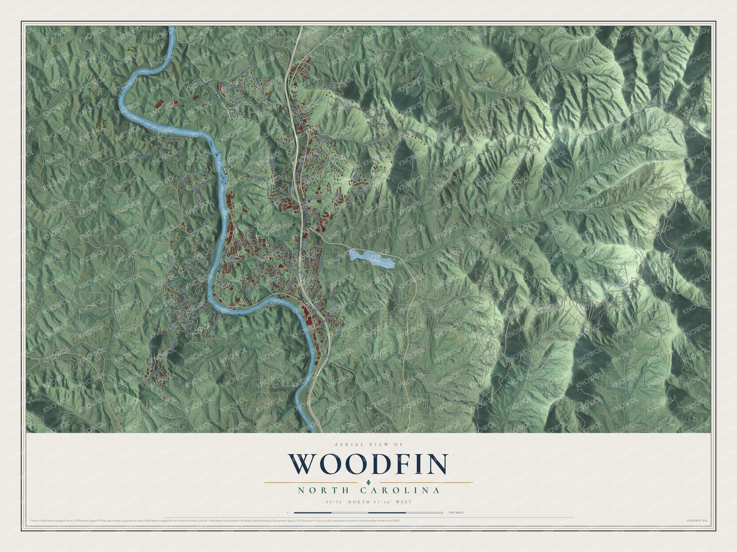
Woodfin, North Carolina Map Art
Building by building, with labeled streets and shaded relief.
12" x 18" Archival Matte Print
A Map of Home. A Work of Art.
Explore Woodfin, North Carolina from a whole new perspective. Created using aerial imagery and detailed geographic data, this map captures Woodfin building by building, with labeled streets, familiar landmarks, and shaded topographical relief that highlights the natural contours of the landscape.
Combining modern data with the timeless character of a vintage atlas, this map is just as interesting up close as it is beautiful on the wall. Whether you grew up in Woodfin, spent memorable years there, or call it home today, this unique map is a great way to celebrate a place that means something to you. Zoom in on the preview to look for your street, and then order a print to put your memories on the wall.
Three ways to hang it

Unframed archival matte, a black wood frame or a white wood frame.
Up close
Geography Worth Displaying
This map was created using accurate cartographic data and authoritative geographic sources, including the U.S. Geological Survey and the Census Bureau. The map brings together terrain, waterways, roads, and building detail. The majority of the streets are labeled, houses are accurately depicted, and the topography is derived from government sources. Combining local data with carefully composed color and shading leads to this beautifully detailed Woodfin artwork for your wall.
Rather than simply showing street outlines, we’ve included as many of the street names as we could reasonably fit on the map while keeping their names legible. Zoom in on the high resolution preview to see exactly what’s on the map. We truly set out to create a statement piece for anyone who loves Woodfin. So whether it’s for you, or a gift for someone you love, we hope this map of Woodfin brings back fond memories.
Read the story behind this map of Woodfin, North Carolina from 2026.

Find your street
Names on the Woodfin map
Every name below is printed on this map. Look for your street, your school, the park where you played, or the pond down the road.
Places and landmarks2
- Elk Mountain
- Chamwood Park
Streets and roads108
- Weaverville Highway
- Weaverville Road
- Riverside Drive
- Farm Road
- Olivette Road
- Elk Mountain Road
- Mills Place
- Old Marshall Highway
- Old Leicester Highway
- Versant Drive
- Elkwood Avenue
- Dimora Drive
- Altura Parkway
- Lookout Road
- Ingle Road
- Serenity Ridge Trail
- Flynn Branch Road
- Old Weaverville Road
- Hollifield Road
- Chimney Crest Drive
- Gosnell Road
- Bannister Drive
- Laurel Terrace
- Northside Drive
- Villa Nova Drive
- Church Road
- Powers Road
- Nelon Road
- Pelzer Street
- Vine Street
Show all 108 streets
- River Run
- Finch Drive
- Skyland Circle
- Mezzo Cv
- Sixth Street
- Denali Drive
- Fox Road
- State Road 1649
- Woodfin Avenue
- State Road 1839
- Sunny Ridge Drive
- Jonestown Road
- Summit Tower Circle
- Baird Cove Road
- Goodman Road
- North Merrimon Avenue
- Dryman Valley Road
- State Road 1654
- River Walk Drive
- Points West Drive
- Ben Lippen Road
- State Road 1712
- French Broad River Way
- Senator Reynolds Road
- Running Ridge Road
- Naples Road
- Green Oak Road
- Charter Gln
- Washington Avenue
- Katies Ridge Drive
- Hickory Street
- Crofoot Trail
- Timber Moss Drive
- Red Tail Ridge
- Verde Drive
- Mulberry Street
- Elk Park Drive
- New Hope Road
- View Street
- Cottage Street
- Reed Street
- Relic Lane
- Norton Drive
- Reese Street
- Rod Drive
- State Road 1367
- Old Beaverdam Creek Road
- Gorman Bridge Road
- State Road 1653
- Greenwood Fields Drive
- Barton Road
- Brookdale Road
- Soaring Hawk Vw
- Old Burnsville Hill Road
- Hogan View Drive
- Wolf Park Circle
- Chestnut Ridge Avenue
- Grey River Run
- Parkwood Avenue
- Bee Balm Way
- Bird's Eye View Drive
- Firethorn Drive
- State Road 2230
- Fern Stone Road
- Terri Drive
- Elkdale Drive
- Union Street
- Broadway Street
- Reynolds Mountain Boulevard
- Crestfield Avenue
- Foothills Road
- Robinhood Road
- Barebridge Hills Drive
- Johnson Road
- Hannah Drive
- State Road 1365
- Bobby Lane
- Nina Street
Names are listed as they appear on the printed map. Zoom into the product photos to find them.
About Woodfin, North Carolina
From the NC State Historic Preservation Office: "Foster’s Log Cabin Court is currently located within the limits of the Town of Woodfin, which was not incorporated until 1971."
Keep exploring North Carolina
Woodfin is one of 952 North Carolina towns we've mapped. Every dot on the map is a print of its own.
The search covers every state, North Carolina first.
Near Woodfin
Order 2 or more town maps and save 10%. Shown in the size and finish you picked above, so they hang as a set.
- Emma 12" x 18" / Archival Matte Print $39.99
- Weaverville 12" x 18" / Archival Matte Print $39.99
- Asheville 12" x 18" / Archival Matte Print $39.99


More maps nearby: Biltmore Forest, Hominy, Bent Creek, Candler and Leicester.
The art of mapping a place
How This Map Was Made
Real places. Remarkable detail. Discover the layers that turn geographic data into a map of home.

The view from above
Aerial imagery reveals the character of the land: woodland, open fields, and the patterns of a place.

The shape of the land
Elevation data brings hills, valleys, and subtle changes in the landscape into view.

The details of home
Roads, waterways, and building footprints come together to make the map feel unmistakably local.

Geography becomes art
Considered color, shading, and typography bring the layers together in a map made for your wall.


Process illustrated with Mendon, Massachusetts. Aerial imagery: USDA NAIP. Terrain: USGS 3D Elevation Program. Map details and finished artwork: KNOWOL.
The Details
About This Print
Choose an archival matte print, or a black or white Ayous wood frame. The archival matte print is unframed.
Select your size and finish above to see the matching product image and price.
Materials & Craftsmanship
A contemporary map with the character of a classic atlas, printed on archival matte paper. Optional frames are made from Ayous wood.
Your printed map does not include the watermark shown in the full-map preview.
Shipping & Delivery
Free shipping within the United States. Every print is made to order in the USA.
Buying a gift? Add a note in your cart and we'll include it. We never put prices in the package.
Prints ship within 2 to 3 business days. Allow 7 to 10 days total from ordering for delivery. Timing may vary during holidays or periods of high order volume.
Read our shipping policy.
Returns and damaged prints
Each print is made to order. Change-of-mind refunds are not available after production.
If your print arrives damaged, misprinted or incorrect, contact support@knowol.com within 30 days of receiving it. Include your order number, photos and a description of the issue.
Read our full refund and replacement policy. For questions about your order, email support@knowol.com.