
Search for another town


Free U.S. delivery 7 to 10 days after you order
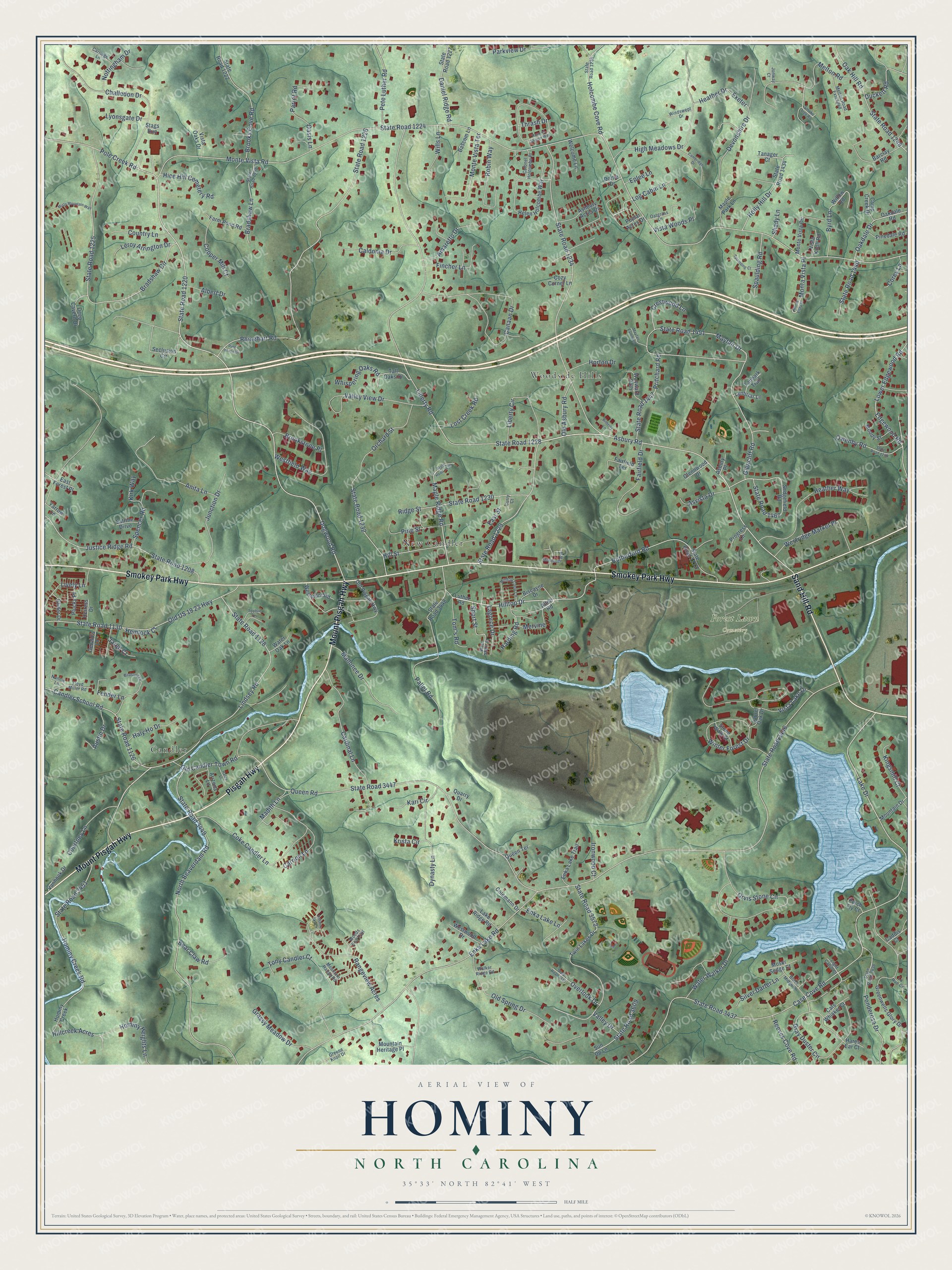
Hominy, North Carolina Map Art
Building by building, with labeled streets and shaded relief.
12" x 18" Archival Matte Print
A Map of Home. A Work of Art.
Explore Hominy, North Carolina from a whole new perspective. Created using aerial imagery and detailed geographic data, this map captures Hominy building by building, with labeled streets, familiar landmarks, and shaded topographical relief that highlights the natural contours of the landscape.
Combining modern data with the timeless character of a vintage atlas, this map is just as interesting up close as it is beautiful on the wall. Whether you grew up in Hominy, spent memorable years there, or call it home today, this unique map is a great way to celebrate a place that means something to you. Zoom in on the preview to look for your street, and then order a print to put your memories on the wall.
Three ways to hang it

Unframed archival matte, a black wood frame or a white wood frame.
Up close
Geography Worth Displaying
This map was created using accurate cartographic data and authoritative geographic sources, including the U.S. Geological Survey and the Census Bureau. The map brings together terrain, waterways, roads, and building detail. The majority of the streets are labeled, houses are accurately depicted, and the topography is derived from government sources. Combining local data with carefully composed color and shading leads to this beautifully detailed Hominy artwork for your wall.
Rather than simply showing street outlines, we’ve included as many of the street names as we could reasonably fit on the map while keeping their names legible. Zoom in on the high resolution preview to see exactly what’s on the map. We truly set out to create a statement piece for anyone who loves Hominy. So whether it’s for you, or a gift for someone you love, we hope this map of Hominy brings back fond memories.
Read the story behind this map: Detailed Map of Hominy, North Carolina.

Find your street
Names on the Hominy map
Every name below is printed on this map. Look for your street, your school, the park where you played, or the pond down the road.
Places and landmarks4
- Forest Lawn Cemetery
- Candler
- New Candler
- Woodside Hills
Streets and roads268
- Smokey Park Highway
- Mount Pisgah Highway
- Pisgah Highway
- Sand Hill Road
- Liberty Road
- State Road 1234
- Hilltop Drive
- East Street
- Courtney Lane
- Dogwood Road
- Gray Duster Circle
- Melton Road
- Maple Ridge Road
- Monte Vista Road
- State Road 1224
- Enka Lake Road
- State Road 3446
- Case Cove Road
- State Road 3437
- Pole Creek Road
- State Road 1220
- Asbury Road
- State Road 1228
- State Road 1451
- Queen Road
- State Road 3447
- North Beaverdam Road
- State Road 3449
- Rhinehart Road
- State Road 1226
Show all 268 streets
- Bradshaw Circle
- State Road 1225
- Lindsey Road
- State Road 1128
- Vista Lake Drive
- Mayfair Drive
- Canaan Drive
- State Road 3572
- Orvis Stone Circle
- Orchard Street
- Old US 19 23 Highway
- State Road 1130
- Carrion Lane
- Justice Ridge Road
- State Road 1208
- Lake Drive
- High Meadows Drive
- Hominy Creek Road
- State Road 3451
- Heather Way
- Rutherford Road
- Old Candler Town Road
- Lower Edgewood Road
- Edgewood Road
- Tony Candler Court
- Pallet Road
- Rangeview Acres
- Glencliff Road
- Candler School Road
- State Road 1126
- State Road 1229
- Ridge Street
- State Road 1230
- Westfield Way
- Oak Hill Road
- State Road 1248
- Ponderosa Drive
- Brooks Cove Road
- State Road 1467
- Junction Drive
- Anita Lane
- Devonshire Drive
- Challedon Drive
- Winter Forest Drive
- Holly Hill Drive
- Dynasty Lane
- Liberty Circle
- Westridge Market Place
- Water Walker Drive
- Fairfield Drive
- Mallonee Drive
- Holcombe Cove Road
- Old Spring Drive
- Robin Way
- State Road 1232
- Pritchard Road
- State Road 1447
- Hill Street
- Valley View Drive
- Coke Candler Lane
- Cardinal Lane
- Monte Vista Terrace
- Caldonia Drive
- Pete Luther Road
- Bradshaw Lane
- Hominy Heights Lane
- Daniel Ridge Road
- Oakdale Drive
- Pine Street
- Grassy Meadow Drive
- Short Street
- Enka Lake Lane
- Owenby Road
- Spencer Road
- Fincher Lane
- State Road 3609
- Lively Lane
- Parkview Drive
- Fender Lane
- Copper Mill Court
- Amaretto Drive
- Hice Hill Cemetery Road
- Leroy Arrington Drive
- Duckett Road
- Spaulding Road
- Hillcreek Acres
- Monta Vista Place
- Kingsmill Court
- Parrot Road
- Overlook Drive
- Silver Darter Lane
- Crestwood Lane
- Country Lane
- Austin Drive
- Haly Ho Drive
- Whispering Oaks Road
- State Road 1440
- Brookstone Place
- Lost Creek Road
- Bear Claw Road
- Old Asbury Road
- Reeves Cove Road
- Asvista Drive
- Vista Woods Place
- Log Cabin Lane
- Harding Road
- Horton Drive
- Lagorce Drive
- Byrd Lane
- Tom's Road
- Nottingham Drive
- Mervine
- Wills Lane
- Lyonsgate Drive
- Albert Drive
- Madith Lane
- Corey Lane
- Ironwood Court
- Heather Drive
- Hemlock Court
- Kirk Way
- Kari Circle
- Valley Drive
- Jared Court
- Krista Circle
- Eplee Lane
- Thrash Drive
- Shady Lane
- Exeter
- Oasis Lane
- Alton Road
- Poplar Acres Drive
- Luther Road
- Westmont Road
- Hominy Creek
- Twin Lakes Drive
- Greenwells Glory Drive
- State Road 1233
- State Road 1222
- Helen Holcombe Way
- State Road 1434
- Sedgefield Road
- State Road 3448
- State Road 1227
- Ashbury Acres Drive
- Oakdale Road
- Old Pisgah Highway
- Seclusion Circle
- Sun Up Lane
- Cats Whisker Court
- Barclay Road
- Monte Vista Circle
- Enka Lake Trail
- Tall Oaks Drive
- Mountain Heritage Place
- Tanager Court
- Biscayne Drive
- Farm Pond Road
- Pinedale Road
- Willow Road
- Wayward Path
- Westwood Drive
- Fairfield Terrace
- Caddis Court
- Deep Cavern Drive
- Mountain Drive
- Bascom Lane
- Colemann Drive
- Maple Park Lane
- Welcome Lane
- Moody Street
- East Forest Place
- Stone Walk Street
- Glider Drive
- Vanhook Drive
- Lake Ridge Road
- Camp Creek Drive
- Plucky Place
- Lynbriar Lane
- Moser Sedge Court
- Gerald's Lane
- Glennwood Drive
- Vista Knoll Road
- Vista Oaks Drive
- Queen Terrace
- Progress Lane
- Tanbark Trail
- Water Oak Lane
- Cozy Corner Lane
- Heiress Drive
- Estrine Dirve
- Laurel Oak Drive
- Hares Ear Court
- Quarry Drive
- Arizona Lane
- Asbury Place
- Yarrow Lane
- Dottie Drive
- Perch Fly Court
- Stags Run
- State Road 3438
- State Road 1236
- State Road 1448
- West Short Street
- Hilltop Loop Lane
- Mountain Range Road
- Floyd Miller Road
- Oatgrass Lane
- Greene Knoll Drive
- Black Midge Lane
- Melton Road Extended
- Colonel Holcombe Place
- Carriage Lane
- Windswept Drive
- Nannie Lane
- Woods End Trail
- Walker Ridge Road
- Light Cahill Court
- Jonway Court
- La Rue Court
- Curry Court
- Smoke Tree Road
- Rose of Sharon Way
- State Road 1436
- State Road 1240
- Monte Vista Place
- State Road 3610
- Cambridge Drive
- Birdsong Lane
- Misty Mountain Way
- Monmouth Way
- Spaulding Court
- Mayfair Extended
- Tootsie Lane
- Pristine Sky Court
- Bilberry Lane
- Haley Lane
- Pine Island Drive
Names are listed as they appear on the printed map. Zoom into the product photos to find them.
Keep exploring North Carolina
Hominy is one of 952 North Carolina towns we've mapped. Every dot on the map is a print of its own.
The search covers every state, North Carolina first.
Near Hominy
Order 2 or more town maps and save 10%. Shown in the size and finish you picked above, so they hang as a set.
- Candler 12" x 18" / Archival Matte Print $39.99
- Bent Creek 12" x 18" / Archival Matte Print $39.99
- Emma 12" x 18" / Archival Matte Print $39.99


More maps nearby: Asheville, Biltmore Forest, Avery Creek, Woodfin and Leicester.
The art of mapping a place
How This Map Was Made
Real places. Remarkable detail. Discover the layers that turn geographic data into a map of home.

The view from above
Aerial imagery reveals the character of the land: woodland, open fields, and the patterns of a place.

The shape of the land
Elevation data brings hills, valleys, and subtle changes in the landscape into view.

The details of home
Roads, waterways, and building footprints come together to make the map feel unmistakably local.

Geography becomes art
Considered color, shading, and typography bring the layers together in a map made for your wall.


Process illustrated with Mendon, Massachusetts. Aerial imagery: USDA NAIP. Terrain: USGS 3D Elevation Program. Map details and finished artwork: KNOWOL.
The Details
About This Print
Choose an archival matte print, or a black or white Ayous wood frame. The archival matte print is unframed.
Select your size and finish above to see the matching product image and price.
Materials & Craftsmanship
A contemporary map with the character of a classic atlas, printed on archival matte paper. Optional frames are made from Ayous wood.
Your printed map does not include the watermark shown in the full-map preview.
Shipping & Delivery
Free shipping within the United States. Every print is made to order in the USA.
Buying a gift? Add a note in your cart and we'll include it. We never put prices in the package.
Prints ship within 2 to 3 business days. Allow 7 to 10 days total from ordering for delivery. Timing may vary during holidays or periods of high order volume.
Read our shipping policy.
Returns and damaged prints
Each print is made to order. Change-of-mind refunds are not available after production.
If your print arrives damaged, misprinted or incorrect, contact support@knowol.com within 30 days of receiving it. Include your order number, photos and a description of the issue.
Read our full refund and replacement policy. For questions about your order, email support@knowol.com.