
Search for another town


Free U.S. delivery 7 to 10 days after you order
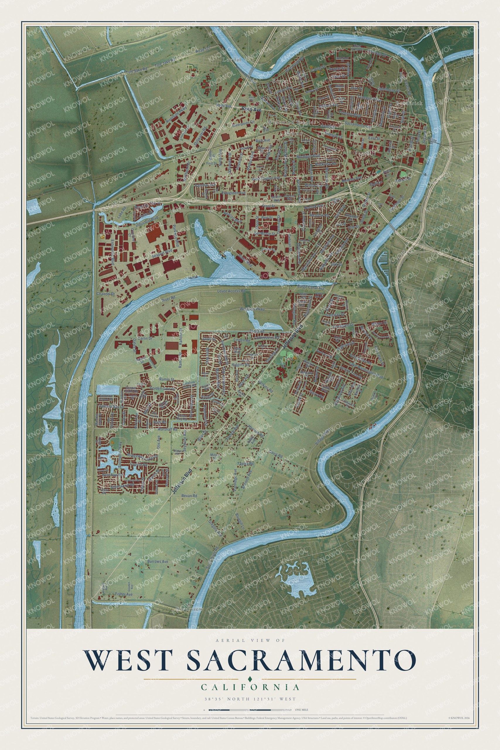
West Sacramento, California Map Art
Building by building, with labeled streets and shaded relief.
12" x 18" Archival Matte Print
A Map of Home. A Work of Art.
Explore West Sacramento, California from a whole new perspective. Created using aerial imagery and detailed geographic data, this map captures West Sacramento building by building, with labeled streets, familiar landmarks, and shaded topographical relief that highlights the natural contours of the landscape.
Combining modern data with the timeless character of a vintage atlas, this map is just as interesting up close as it is beautiful on the wall. Whether you grew up in West Sacramento, spent memorable years there, or call it home today, this unique map is a great way to celebrate a place that means something to you. Zoom in on the preview to look for your street, and then order a print to put your memories on the wall.
Three ways to hang it

Unframed archival matte, a black wood frame or a white wood frame.
Up close
Geography Worth Displaying
This map was created using accurate cartographic data and authoritative geographic sources, including the U.S. Geological Survey and the Census Bureau. The map brings together terrain, waterways, roads, and building detail. The majority of the streets are labeled, houses are accurately depicted, and the topography is derived from government sources. Combining local data with carefully composed color and shading leads to this beautifully detailed West Sacramento artwork for your wall.
Rather than simply showing street outlines, we’ve included as many of the street names as we could reasonably fit on the map while keeping their names legible. Zoom in on the high resolution preview to see exactly what’s on the map. We truly set out to create a statement piece for anyone who loves West Sacramento. So whether it’s for you, or a gift for someone you love, we hope this map of West Sacramento brings back fond memories.
Read the story behind this map of West Sacramento, California from 2026.

Find your street
Names on the West Sacramento map
Every name below is printed on this map. Look for your street, your school, the park where you played, or the pond down the road.
Places and landmarks7
- Riverview
- Lovdal
- Broderick
- Bryte
- Mikon
- Westwind Estates
- Peethill
Streets and roads286
- Jefferson Boulevard
- Reed Avenue
- Second Street
- West Capitol Avenue
- Park Boulevard
- East Street
- Harbor Boulevard
- Oakland Bay Drive
- Summerfield Drive
- Marshall Road
- Fountain Drive
- Gateway Drive
- Claredon Street
- Sycamore Avenue
- South River Road
- Levee Access Road
- Southport Parkway
- Village Parkway
- Linden Road
- River Road
- Industrial Boulevard
- Lake Washington Boulevard
- Davis Road
- Westport Parkway
- Stonegate Drive
- Enterprise Boulevard
- Stone Boulevard
- Thorp Road
- Bridgeway Lakes Drive
- Evergreen Avenue
Show all 286 streets
- Road 127
- Tule Jake Road
- Tule Sake Road
- Ramco Street
- Ramlo Street
- Rancho Street
- Gregory Avenue
- Golden Gate Drive
- Riverbank Road
- Allan Avenue
- Riverpoint Circle
- Westacre Road
- Seaport Boulevard
- Burrows Avenue
- Bevan Road
- Channel Drive
- Otis Avenue
- Riverside Parkway
- Lighthouse Drive
- Virginia Avenue
- Partridge Avenue
- Merkley Avenue
- Cummins Way
- Michigan Boulevard
- Anna Street
- Delaware Avenue
- Sunset Avenue
- Hobson Avenue
- Maryland Avenue
- Antioch Avenue
- Poplar Avenue
- Alabama Avenue
- Carrie Street
- Kegle Drive
- Third Street
- Higgins Road
- Terminal Street
- Sacramento Avenue
- Levee Road
- Lisbon Avenue
- Sand Circle
- Sixth Street
- Fourth Street
- Redwood Avenue
- Yolo Street
- Walnut Avenue
- Walnut Street
- Meadow Road
- Highland Drive
- 19th Street
- Parkway Boulevard
- Douglas Drive
- French Avenue
- Stillwater Road
- Carlin Drive
- Mojave Drive
- Rice Avenue
- Silverwood Road
- Pecan Street
- Del Monte Street
- 15th Street
- Maple Street
- Harmon Road
- Glide Avenue
- Riverfront Street
- Barge Canal Acc
- Cebrian Street
- Greenbrier Road
- Eighth Street
- Coyote Road
- Deerwood Street
- Betty Way
- Solano Street
- Lake Road
- Fremont Boulevard
- Rockrose Road
- Seymore Avenue
- Fisher Avenue
- Arlington Road
- Sutter Avenue
- Ryer Island Street
- Canvasback Way
- Houston Street
- Kinsington Street
- Water Street
- Lemon Tree Drive
- Soule Street
- Martis Street
- Drever Street
- Myrtle Avenue
- Beacon Boulevard
- Arthur Drive
- Willow Avenue
- Bragi Drive
- Coffeeberry Road
- Mareca Way
- Tahoe Street
- Beardsley Drive
- Perkins Road
- Shore Street
- Henshaw Road
- Teal Drive
- Rivermont Street
- Oates Street
- Front Street
- Triangle Court
- Barona Street
- Galveston Street
- Key Largo Street
- Sierra Road
- Northport Drive
- Port Street
- Palomar Avenue
- Norfolk Avenue
- Rogers Street
- Starling Lane
- Bluegill Lane
- Vaten Drive
- Allan Drive
- Lassik Street
- Milano Street
- Geary Street
- Taber Street
- Julian Drive
- Tapley Road
- Prosser Street
- Janet Drive
- Steel Lane
- Lilac Lane
- Maui Street
- Violet Drive
- Aruba Street
- Joan Street
- Haiti Road
- Malcolm Island Street
- North Harbor Boulevard
- River Crest Drive
- Bryte Avenue
- Eleventh Street
- Fernwood Street
- Trinity Way
- Hardy Drive
- Ballpark Drive
- Pitzer Circle
- Alder Way
- Duluth Street
- Thor Drive
- Hart Avenue
- Shaw Drive
- Suisun Bay Road
- 13th Street
- Oak Street
- Topaz Road
- San Salvador Street
- Rubicon Way
- Catalina Island Road
- Kiline Street
- Solomon Island Road
- Cooper Island Road
- Hilary Avenue
- Spokane Road
- Fiji Island Street
- Martinique Street
- Quail Road
- Benton Street
- Kauai Road
- Muscovy Road
- Garnet Street
- Aster Avenue
- Simon Terrace
- Turlock Street
- Spruce Street
- Crown Avenue
- Lagoon Lane
- First Street
- Overland Court
- Milton Street
- Mallard Road
- Rich Street
- Drew Street
- Seventh Street
- Middle Street
- Ramos Drive
- West Street
- Bastone Court
- Short Street
- Hearst Street
- Tyler Way
- Sellers Way
- Hume Street
- Delta Lane
- Miller Court
- Ash Avenue
- Swift Street
- Alvin Street
- Todhunter Avenue
- Valley Oak Lane
- Laurel Lane
- Elm Street
- Webster Street
- Coranado Street
- Regatta Lane
- Lewiston Road
- Berry Creek Road
- Tamarack Road
- Fairway Drive
- Portsmouth Avenue
- Boatman Avenue
- Odin Drive
- Tortola Road
- Ballena Bay Road
- Oakmont Way
- Village Club Drive
- La Jolla Street
- Goodell Avenue
- Wigeon Street
- Waterford Drive
- California Street
- Jamaica Street
- Saginaw Street
- Gladys Avenue
- Blacker Road
- Armfield Avenue
- Asante Lane
- Brenda Way
- Oxford Street
- Diane Drive
- Pecan Court
- Kovr Drive
- Safflower Place
- 17th Street
- Embarcadero Drive
- Haverhill Street
- Jasmine Avenue
- May Street
- Proctor Avenue
- Woodhaven Place
- Lakewood Drive
- Rumsey Street
- Duet Drive
- Promenade Street
- Bridge Street
- Holly Street
- Buckeye Drive
- Fowler Road
- Audubon Drive
- Pine Avenue
- Randolph Road
- Otay Street
- Pilot Point Road
- Olive Court
- Presidio Road
- Nichlos Court
- Flossie Avenue
- Cherry Place
- Tower Street
Names are listed as they appear on the printed map. Zoom into the product photos to find them.
About West Sacramento, California
West Sacramento is a city of 53,915 people in Yolo County, across the Sacramento River from the state capital. In 1844, when this land still belonged to Mexico, a Flemish traveler named John Schwartz put up a shack on the river's west bank. With his brother George he started a salmon fishery, and the two also farmed and raised livestock. In 1846 James McDowell bought 600 acres from Schwartz and settled his wife, Margaret, and their three daughters where Broderick stands today.
In May 1849 McDowell was shot dead in a barroom quarrel. Margaret needed to support her daughters, so that October she had a surveyor lay out 160 acres in blocks and began selling lots in what she called the Town of Washington. August W. Kaye paid $500 for the first one. Hotels, saloons and restaurants soon served travelers crossing the marshes toward Sacramento, and the California Steam Navigation Company set up here in 1859.
- Mike Bryte's dairyMike Bryte came to California in 1849 to look for gold. He never got rich mining, but he found enough to buy a dairy farm, and he shipped his dairy goods to market on the steamers that stopped at Washington. The profits let him build up several thousand acres. He sat on the county's Board of Supervisors and then became sheriff of Yolo County, and in the 20th century his land was divided into the community of Bryte.
- First salmon cannery, 1864Hapgood, Hume and Company opened California's first Pacific Coast salmon cannery in 1864 in Washington, the town now called Broderick. A state historical marker shows the approximate site, near the Sacramento River.
- Three towns, one city in 1987The Town of Washington was renamed Broderick for U.S. Senator David C. Broderick. After 1900, Bryte, Broderick and West Sacramento were known together as East Yolo, and their population doubled from 1,398 to 2,638 by 1920. The West Sacramento post office opened in 1915, and the communities finally incorporated as one city in 1987.
- Ocean ships since 1963Congress approved a deep water channel to Sacramento in 1946, and digging started on the river's west side in 1949. The Sacramento Deep Water Ship Channel opened the port to ocean traffic in June 1963. Now called the Port of West Sacramento, it brings in cement and ships out rice.
Keep exploring California
West Sacramento is one of 1,990 California towns we've mapped. Every dot on the map is a print of its own.
The search covers every state, California first.
Near West Sacramento
Order 2 or more town maps and save 10%. Shown in the size and finish you picked above, so they hang as a set.
- Sacramento 12" x 18" / Archival Matte Print $39.99
- Fruitridge Pocket 12" x 18" / Archival Matte Print $39.99
- Lemon Hill 12" x 18" / Archival Matte Print $39.99


More maps nearby: Parkway, Freeport, El Macero, Ben Ali and Florin.
The art of mapping a place
How This Map Was Made
Real places. Remarkable detail. Discover the layers that turn geographic data into a map of home.

The view from above
Aerial imagery reveals the character of the land: woodland, open fields, and the patterns of a place.

The shape of the land
Elevation data brings hills, valleys, and subtle changes in the landscape into view.

The details of home
Roads, waterways, and building footprints come together to make the map feel unmistakably local.

Geography becomes art
Considered color, shading, and typography bring the layers together in a map made for your wall.


Process illustrated with Mendon, Massachusetts. Aerial imagery: USDA NAIP. Terrain: USGS 3D Elevation Program. Map details and finished artwork: KNOWOL.
The Details
About This Print
Choose an archival matte print, or a black or white Ayous wood frame. The archival matte print is unframed.
Select your size and finish above to see the matching product image and price.
Materials & Craftsmanship
A contemporary map with the character of a classic atlas, printed on archival matte paper. Optional frames are made from Ayous wood.
Your printed map does not include the watermark shown in the full-map preview.
Shipping & Delivery
Free shipping within the United States. Every print is made to order in the USA.
Buying a gift? Add a note in your cart and we'll include it. We never put prices in the package.
Prints ship within 2 to 3 business days. Allow 7 to 10 days total from ordering for delivery. Timing may vary during holidays or periods of high order volume.
Read our shipping policy.
Returns and damaged prints
Each print is made to order. Change-of-mind refunds are not available after production.
If your print arrives damaged, misprinted or incorrect, contact support@knowol.com within 30 days of receiving it. Include your order number, photos and a description of the issue.
Read our full refund and replacement policy. For questions about your order, email support@knowol.com.