
Search for another town


Free U.S. delivery 7 to 10 days after you order
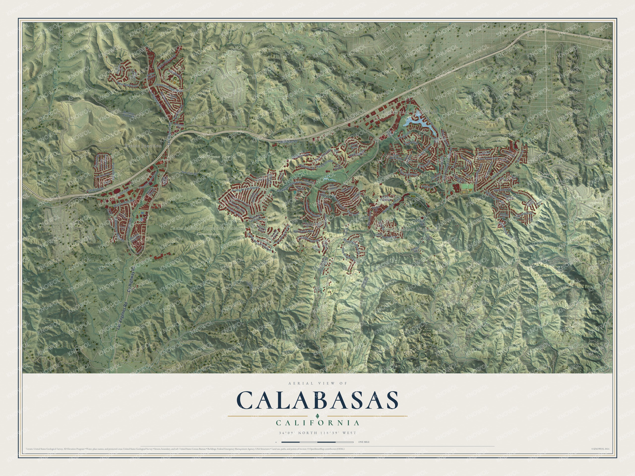
Calabasas, California Map Art
Building by building, with labeled streets and shaded relief.
12" x 18" Archival Matte Print
A Map of Home. A Work of Art.
Explore Calabasas, California from a whole new perspective. Created using aerial imagery and detailed geographic data, this map captures Calabasas building by building, with labeled streets, familiar landmarks, and shaded topographical relief that highlights the natural contours of the landscape.
Combining modern data with the timeless character of a vintage atlas, this map is just as interesting up close as it is beautiful on the wall. Whether you grew up in Calabasas, spent memorable years there, or call it home today, this unique map is a great way to celebrate a place that means something to you. Zoom in on the preview to look for your street, and then order a print to put your memories on the wall.
Three ways to hang it

Unframed archival matte, a black wood frame or a white wood frame.
Up close
Geography Worth Displaying
This map was created using accurate cartographic data and authoritative geographic sources, including the U.S. Geological Survey and the Census Bureau. The map brings together terrain, waterways, roads, and building detail. The majority of the streets are labeled, houses are accurately depicted, and the topography is derived from government sources. Combining local data with carefully composed color and shading leads to this beautifully detailed Calabasas artwork for your wall.
Rather than simply showing street outlines, we’ve included as many of the street names as we could reasonably fit on the map while keeping their names legible. Zoom in on the high resolution preview to see exactly what’s on the map. We truly set out to create a statement piece for anyone who loves Calabasas. So whether it’s for you, or a gift for someone you love, we hope this map of Calabasas brings back fond memories.
Read the story behind this map of Calabasas, California from 2026.

Find your street
Names on the Calabasas map
Every name below is printed on this map. Look for your street, your school, the park where you played, or the pond down the road.
Places and landmarks5
- Calabasas City Hall
- Brents Junction
- Calabasas Highlands
- Las Virgenes View Park
- Santa Monica Mountains National Recreation Area
Streets and roads131
- County Highway N1
- Las Virgenes Road
- Lost Hills Road
- Pso Primario
- Agoura Road
- Parkway Calabasas
- Mulholland Highway
- Calabasas Road
- Park Granada
- Old Topanga Canyon Road
- Park Sienna
- Thousand Oaks Boulevard
- Parkmor Road
- Mountain Park Drive
- Ruthwood Drive
- Paul Revere Drive
- Dardenne Street
- Liberty Bell Road
- Prado de Las Flores
- Adamsville Avenue
- Park Entrada
- Calabasas Hills Road
- Malibu Hills Road
- Eddingham Avenue
- Country Creek Lane
- Park Helena
- Cairnloch Street
- Adamor Road
- West Alsace Drive
- Canwood Street
Show all 131 streets
- Prado de la Felicidad
- Towhee Drive
- Prado de Oro
- Park Verdi
- Park Alisal
- Parkville Road
- Alizia Canyon Drive
- Cordillera Drive
- Declaration Avenue
- Park Colombo
- Avenue Callada
- Palm Drive
- Vicasa Drive
- Oak Ridge Terrace
- Summit Drive
- Pso del Rancho
- Cll Largo
- Palermo Drive
- Park Casino
- Norman's Way
- Esward Drive
- Alcamo Drive
- Park Arroyo
- Cll Canon
- Cangas Drive
- Elm Drive
- Morrison Ranch Road
- Park Ora
- Dry Canyon Cold Creek Road
- Gun Club Road
- Park Sorrento
- Park Belmonte
- De Kalb Drive
- Bonhomme Road
- Cordova Drive
- Bluebird Drive
- Willow Glen Street
- Prado del Trigo
- Via del Prado
- Prado de Azul
- Prado de Las Fresas
- Park Capri
- Prado del Grandioso
- Blackbird Way
- Calipatria Drive
- Prado de la Puma
- Park South Street
- De Grasse Drive
- Palmilla Drive
- Meadow Creek Lane
- Cll Joaquin
- Helmond Drive
- Hatmor Drive
- Balcony Drive
- Balder Drive
- Mureau Road
- Via Verde Court
- Valdez Road
- Lorenzo Court
- Ariella Drive
- Via Pradera
- Park Rosso
- Park Vicente
- Via Tecolote
- Galilee Street
- Cll Cedro
- Cam del Sol
- Reina Court
- West Alsace
- Lido Court
- Earls Court
- Hill Road
- Canyon Drive
- Jameson Drive
- Meadowlark Drive
- Prado de Las Bellotas
- Mont Calabasas
- Calabasas Peak Mtwy
- Pso del Sol
- Provence Drive
- Park Miramar
- Prado de Ambar
- Dorothy Road
- Garret Drive
- Delia Court
- Dino Court
- Paul Revere Road
- Ambridge Drive
- El Encanto Drive
- Prado de Los Pajaros
- Prado de Los Gansos
- Stokes Canyon Road
- Saint Andrews Lane
- Cold Springs Street
- Pulido Court
- Daniela Court
- Shadow Hills Road
- Carsamba Drive
- Prado del Misterio
- Lemans Drive
- Cactus Trail
Names are listed as they appear on the printed map. Zoom into the product photos to find them.
About Calabasas, California
Calabasas is a city of 23,241 people in Los Angeles County, at the southwest edge of the San Fernando Valley, where the low slopes of the Santa Monica and Santa Susana mountains rise. The Chumash and Tongva lived in the valley for thousands of years before Spanish explorers arrived. Gaspar de Portolá's expedition crossed this ground in 1770 on its way back to Mexico, and Juan Bautista de Anza's party camped here in 1776 while traveling north.
The name comes from calabazas, the Spanish word for winter squashes, because wild squash grew all over the area. The Spanish botanist José Longinos Martínez wrote down Las Calabazas as a place name in 1792, and by 1795 a ranchería in the Los Angeles area carried the name Calabasas. The community became a city on April 5, 1991, so it is the youngest city in Los Angeles County.
- The Leonis Adobe, from 1844The Leonis Adobe stands in Old Town Calabasas and dates to 1844. That makes it one of the oldest buildings still standing anywhere in greater Los Angeles, and it joined the National Register in 1975.
- An old artists' colonyPark Moderne, behind Calabasas High School, is one of the city's oldest neighborhoods. It began as a colony for artists, and pieces of its clubhouse, pool and cabins still survive there. Because its streets are all named for birds, people call it the Bird Streets.
- Open space by popular voteIn 2005 Calabasas voters passed Measure D by a wide margin. Under it, no land the city has set aside as open space can be turned to another use unless two-thirds of voters approve. The next year the city banned smoking in nearly all public places, a law that took effect on March 16, 2006, and drew attention from local and national media.
- Home of the Cheesecake FactoryThe Cheesecake Factory, Harbor Freight Tools and DTS, Inc. all have their headquarters in Calabasas. During the dot-com bubble, so many networking and software firms gathered in one part of the city that it earned the nickname "101 Technology Corridor," and a strong technology presence remains there.
Keep exploring California
Calabasas is one of 1,990 California towns we've mapped. Every dot on the map is a print of its own.
The search covers every state, California first.
Near Calabasas
Order 2 or more town maps and save 10%. Shown in the size and finish you picked above, so they hang as a set.
- Hidden Hills 12" x 18" / Archival Matte Print $39.99
- Woodland Hills 12" x 18" / Archival Matte Print $39.99
- Topanga 12" x 18" / Archival Matte Print $39.99


More maps nearby: Bell Canyon, West Hills, Agoura Hills, Oak Park and Pepperdine University.
The art of mapping a place
How This Map Was Made
Real places. Remarkable detail. Discover the layers that turn geographic data into a map of home.

The view from above
Aerial imagery reveals the character of the land: woodland, open fields, and the patterns of a place.

The shape of the land
Elevation data brings hills, valleys, and subtle changes in the landscape into view.

The details of home
Roads, waterways, and building footprints come together to make the map feel unmistakably local.

Geography becomes art
Considered color, shading, and typography bring the layers together in a map made for your wall.


Process illustrated with Mendon, Massachusetts. Aerial imagery: USDA NAIP. Terrain: USGS 3D Elevation Program. Map details and finished artwork: KNOWOL.
The Details
About This Print
Choose an archival matte print, or a black or white Ayous wood frame. The archival matte print is unframed.
Select your size and finish above to see the matching product image and price.
Materials & Craftsmanship
A contemporary map with the character of a classic atlas, printed on archival matte paper. Optional frames are made from Ayous wood.
Your printed map does not include the watermark shown in the full-map preview.
Shipping & Delivery
Free shipping within the United States. Every print is made to order in the USA.
Buying a gift? Add a note in your cart and we'll include it. We never put prices in the package.
Prints ship within 2 to 3 business days. Allow 7 to 10 days total from ordering for delivery. Timing may vary during holidays or periods of high order volume.
Read our shipping policy.
Returns and damaged prints
Each print is made to order. Change-of-mind refunds are not available after production.
If your print arrives damaged, misprinted or incorrect, contact support@knowol.com within 30 days of receiving it. Include your order number, photos and a description of the issue.
Read our full refund and replacement policy. For questions about your order, email support@knowol.com.