


Search for another town


Free U.S. delivery 7 to 10 days after you order
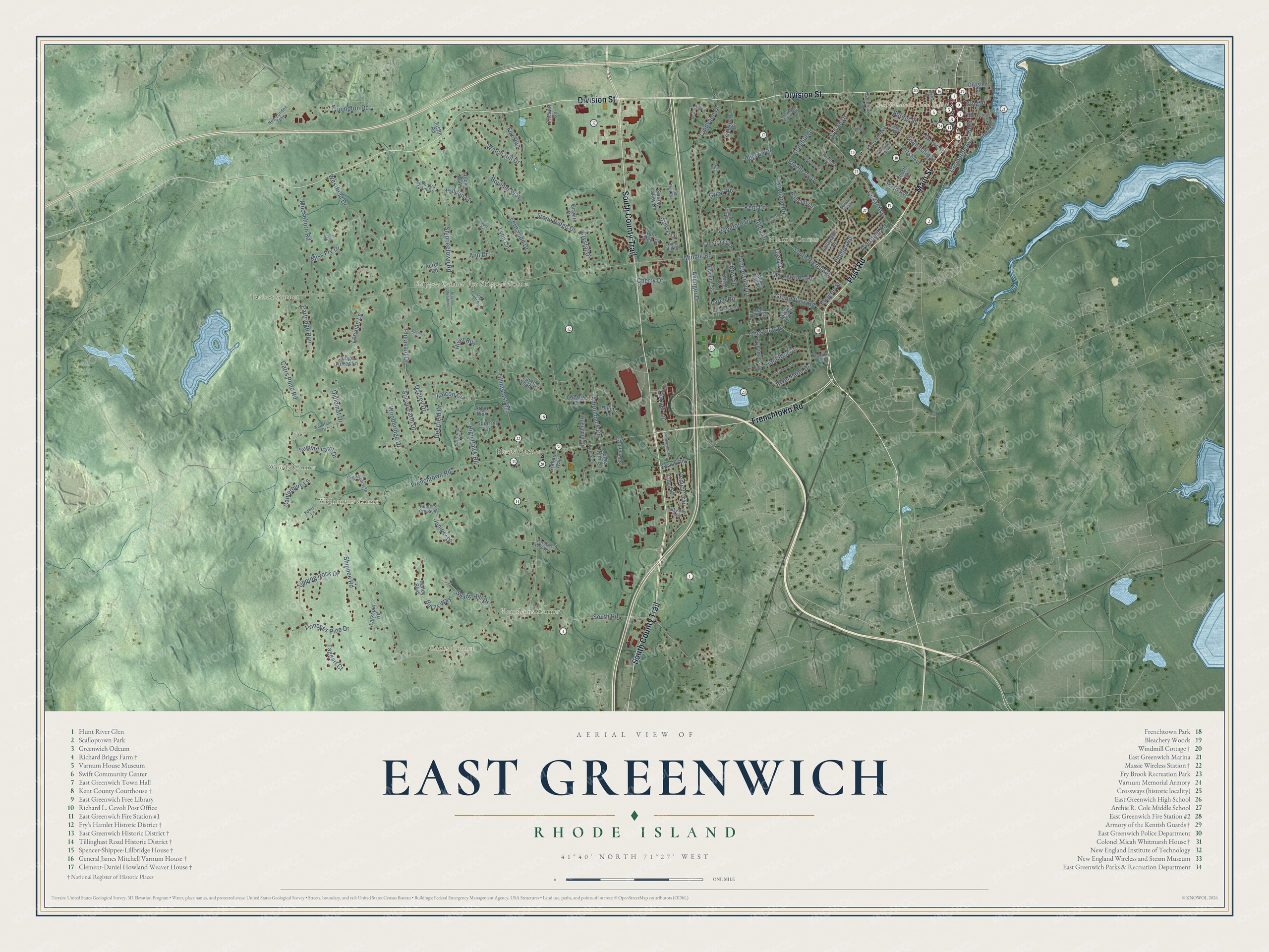
East Greenwich, Rhode Island Map Art
Building by building, with labeled streets and shaded relief.
12" x 18" Archival Matte Print
A Map of Home. A Work of Art.
Explore East Greenwich, Rhode Island from a whole new perspective. Created using aerial imagery and detailed geographic data, this map captures East Greenwich building by building, with labeled streets, familiar landmarks, and shaded topographical relief that highlights the natural contours of the landscape.
Combining modern data with the timeless character of a vintage atlas, this map is just as interesting up close as it is beautiful on the wall. Whether you grew up in East Greenwich, spent memorable years there, or call it home today, this unique map is a great way to celebrate a place that means something to you. Zoom in on the preview to look for your street, and then order a print to put your memories on the wall.
Three ways to hang it

Unframed archival matte, a black wood frame or a white wood frame.
Up close
Geography Worth Displaying
This map was created using accurate cartographic data and authoritative geographic sources, including the U.S. Geological Survey (USGS) and FEMA. The map brings together terrain, waterways, roads, and building detail. The majority of the streets are labeled, houses are accurately depicted, and the topography is derived from government sources. Combining local data with carefully composed color and shading leads to this beautifully detailed East Greenwich artwork for your wall.
Rather than simply showing street outlines, we’ve included as many of the street names as we could reasonably fit on the map while keeping their names legible. Zoom in on the high resolution preview to see exactly what’s on the map. We truly set out to create a statement piece for anyone who loves East Greenwich. So whether it’s for you, or a gift for someone you love, we hope this map of East Greenwich brings back fond memories.
Explore the full map of East Greenwich, Rhode Island and read about the local places it shows.

Find your street
Names on the East Greenwich map
Every name below is printed on this map. Look for your street, your school, the park where you played, or the pond down the road.
Places and landmarks10
- East Greenwich Town Hall
- Cooks Corner
- Woods Corner
- Tarbox Corner
- Places Corner
- Ike Shippee Corner
- Nichols Corner
- Hamiltons Corner
- Shippee Corner
- Wightmans Corner
Streets and roads150
- Main Street
- Post Road
- Division Street
- South County Trail
- Frenchtown Road
- Chestnut Drive
- King Street
- Duke Street
- Friendship Street
- Middle Road
- South Road
- Tillinghast Road
- Carrs Pond Road
- Shippeetown Road
- Cedar Avenue
- High Hawk Road
- Cindyann Drive
- Howland Road
- Westfield Drive
- Shippee Road
- Stone Ridge Drive
- First Avenue
- Adirondack Drive
- Kent Drive
- Moosehorn Road
- Watch Hill Drive
- Grand View Road
- Woodbridge Drive
- Deerfield Drive
- River Farm Drive
Show all 150 streets
- Tipping Rock Drive
- River Run
- Lenihan Lane
- Crompton Road
- Avenger Drive
- Pequot Trail
- Lynn Circle
- Tanglewood Drive
- Shady Hill Drive
- South Pierce Road
- Miss Fry Drive
- Juniper Drive
- Princess Pine Drive
- Spring Street
- Pheasant Drive
- Maplewood Drive
- Partridge Run
- Overfield Road
- Fox Run
- Boulder Way
- Dalehill Drive
- Sheep Farm Drive
- Falcon Circle
- Hamilton Drive
- Hanaford Drive
- Bow Street
- Summit Farm Drive
- Osprey Drive
- Ann Drive
- Great Road
- Sylvan Drive
- Phillips Road
- Fernwood Drive
- Crompton Avenue
- Canterbury Lane
- Taggart Court
- Blueberry Drive
- Crystal Drive
- Cooper Lane
- Allen Drive
- Sixth Avenue
- Larch Road
- Diplomat Drive
- Balsam Drive
- Hidden Lane
- Eugene Street
- Burns Way
- Pegwin Drive
- Glen Drive
- Cherry Drive
- Sunset Drive
- London Street
- Spring Valley Drive
- Bailey Boulevard
- Kenyon Avenue
- Pine Glen Drive
- Laurel Wood Drive
- Sanctuary Drive
- Cavalier Drive
- Larkspur Road
- Laurel Hill Road
- Downing Street
- Squirrel Lane
- Sycamore Drive
- Fourth Street
- Crestridge Drive
- Rock Way
- Jodie Beth Drive
- Sawmill Court
- Granite Drive
- Misty Oak Drive
- Graham Way
- Huguenot Drive
- Valley Road
- Huling Lane
- Ayrault Road
- Lafayette Drive
- Judge Torres Lane
- Greene Street
- Aurora Road
- Crickett Circle
- Red Oak Road
- Devon Court
- Justin Road
- Arbor Way
- Hemlock Drive
- Tamarack Drive
- Red Barn Lane
- Long Meadow Drive
- Howland Farm Road
- Queen Street
- Spencers Grant Drive
- Oak Dell Circle
- Pardons Wood Lane
- Cardinal Lane
- Virginia Avenue
- New London Turnpike
- Forest Lane
- Kirker Drive
- Old Farm Road
- Overbrook Lane
- Hunters Crossing
- Gould Place
- Franklin Road
- Ledge Road
- Sarahs Trce
- Corr Way
- Pine Hill Drive
- Darl Court
- Silo Lane
- Waterford Drive
- Brisas Circle
- Jefferson Drive
- Meadowbrook Road
- Rector Street
- Oakwood Drive
- Nichols Lane
- Brayton Meadows
- King Philip Trail
- Sparrow Lane
Names are listed as they appear on the printed map. Zoom into the product photos to find them.
About East Greenwich, Rhode Island
East Greenwich is a town of 14,312 people and the county seat of Kent County, on the western side of Narragansett Bay. In October 1677 the General Assembly created it as Greenwich, after Greenwich, England, to strengthen Rhode Island's hold on land that Connecticut also claimed. The Assembly set aside 5,000 acres and gave land to 48 veterans of King Phillip's War. Settlers came quickly enough to stop Connecticut from moving its border east. The town was briefly called Dedford, from 1686 to 1689. In 1687 the Narragansett Proprietors tried to settle land north of Wickford that overlapped the town, but Sir Edmund Andros, the Massachusetts governor, ruled for East Greenwich.
Starting in 1711, the town sold small lots by the water for a shilling each to anyone who promised to put up a building. By 1725 a village stood there, with a schoolhouse and a graveyard. The town was so large that people struggled to reach town meetings, so in 1741 the rural western part, three-quarters of the land, became West Greenwich. The remaining quarter took the name East Greenwich.
- A state capital until 1854Kent County was carved from Providence County in 1750, and its shire town, East Greenwich, built a courthouse. Until 1854 it was among Rhode Island's five capitals, and the General Assembly met there whenever it sat in town. Revolutionary War veteran Oliver Wickes began today's Kent County Courthouse on Main Street in 1804, and it got a Colonial Revival interior in 1909. When Warwick got a new county courthouse in 1974, it became Town Hall, where probate court still sits.
- A navy in 1772On June 12, 1772, while meeting in East Greenwich, the Assembly voted to form a navy of two ships, the Katy and the Washington, which the town counts as the first navy of the United States. The Assembly named Captain Abraham Whipple its commodore and put him in charge of both ships.
- General Varnum's houseJames Mitchell Varnum had his house on Peirce Street built in 1773, before he served as a general in the Continental Army. A portico of fluted Ionic columns frames the front door. George A. Brayton, a chief justice of the Rhode Island Supreme Court, lived there in later years. The Varnum Continentals bought the house in 1939 and have run it as a museum ever since.
- Scalloptown on the coveIn the 19th century, Irish, Italian, German and Scandinavian newcomers and free Black families settled the waterfront at Scalloptown, named for the scallops many caught and sold. White writers and town leaders dismissed it as a lawless shantytown. The neighborhood reached its height between 1890 and 1913. Sarah Fernandis opened Neighborhood House, a settlement house, there in 1908. In 1913 the town council ruled many homes unfit and ordered families out, and by 1926 most of Scalloptown had been destroyed.
- Three families, one farmThe farmhouse at Crossways Farm on Middle Road is usually dated to 1772, though it may be older. The related Spencer, Shippee and Lillbridge families worked its 225 acres from the start until 2001. A small nineteenth-century addition gave the hired hands a stair of their own up to their attic rooms. The house is listed today as the Spencer-Shippee-Lillbridge House.
Keep exploring Rhode Island
East Greenwich is one of 86 Rhode Island towns we've mapped. Every dot on the map is a print of its own.
The search covers every state, Rhode Island first.
Near East Greenwich
Order 2 or more town maps and save 10%. Shown in the size and finish you picked above, so they hang as a set.
- Frenchtown 12" x 18" / Archival Matte Print $39.99
- West Warwick 12" x 18" / Archival Matte Print $39.99
- Davisville 12" x 18" / Archival Matte Print $39.99


More maps nearby: Wickford, Washington, North Kingstown, Warwick and Hamilton.
The art of mapping a place
How This Map Was Made
Real places. Remarkable detail. Discover the layers that turn geographic data into a map of home.

The view from above
Aerial imagery reveals the character of the land: woodland, open fields, and the patterns of a place.

The shape of the land
Elevation data brings hills, valleys, and subtle changes in the landscape into view.

The details of home
Roads, waterways, and building footprints come together to make the map feel unmistakably local.

Geography becomes art
Considered color, shading, and typography bring the layers together in a map made for your wall.


Process illustrated with Mendon, Massachusetts. Aerial imagery: USDA NAIP. Terrain: USGS 3D Elevation Program. Map details and finished artwork: KNOWOL.
The Details
About This Print
Choose an archival matte print, or a black or white Ayous wood frame. The archival matte print is unframed.
Select your size and finish above to see the matching product image and price.
Materials & Craftsmanship
A contemporary map with the character of a classic atlas, printed on archival matte paper. Optional frames are made from Ayous wood.
Your printed map does not include the watermark shown in the full-map preview.
Shipping & Delivery
Free shipping within the United States. Every print is made to order in the USA.
Buying a gift? Add a note in your cart and we'll include it. We never put prices in the package.
Prints ship within 2 to 3 business days. Allow 7 to 10 days total from ordering for delivery. Timing may vary during holidays or periods of high order volume.
Read our shipping policy.
Returns and damaged prints
Each print is made to order. Change-of-mind refunds are not available after production.
If your print arrives damaged, misprinted or incorrect, contact support@knowol.com within 30 days of receiving it. Include your order number, photos and a description of the issue.
Read our full refund and replacement policy. For questions about your order, email support@knowol.com.