
Search for another town


Free U.S. delivery 7 to 10 days after you order
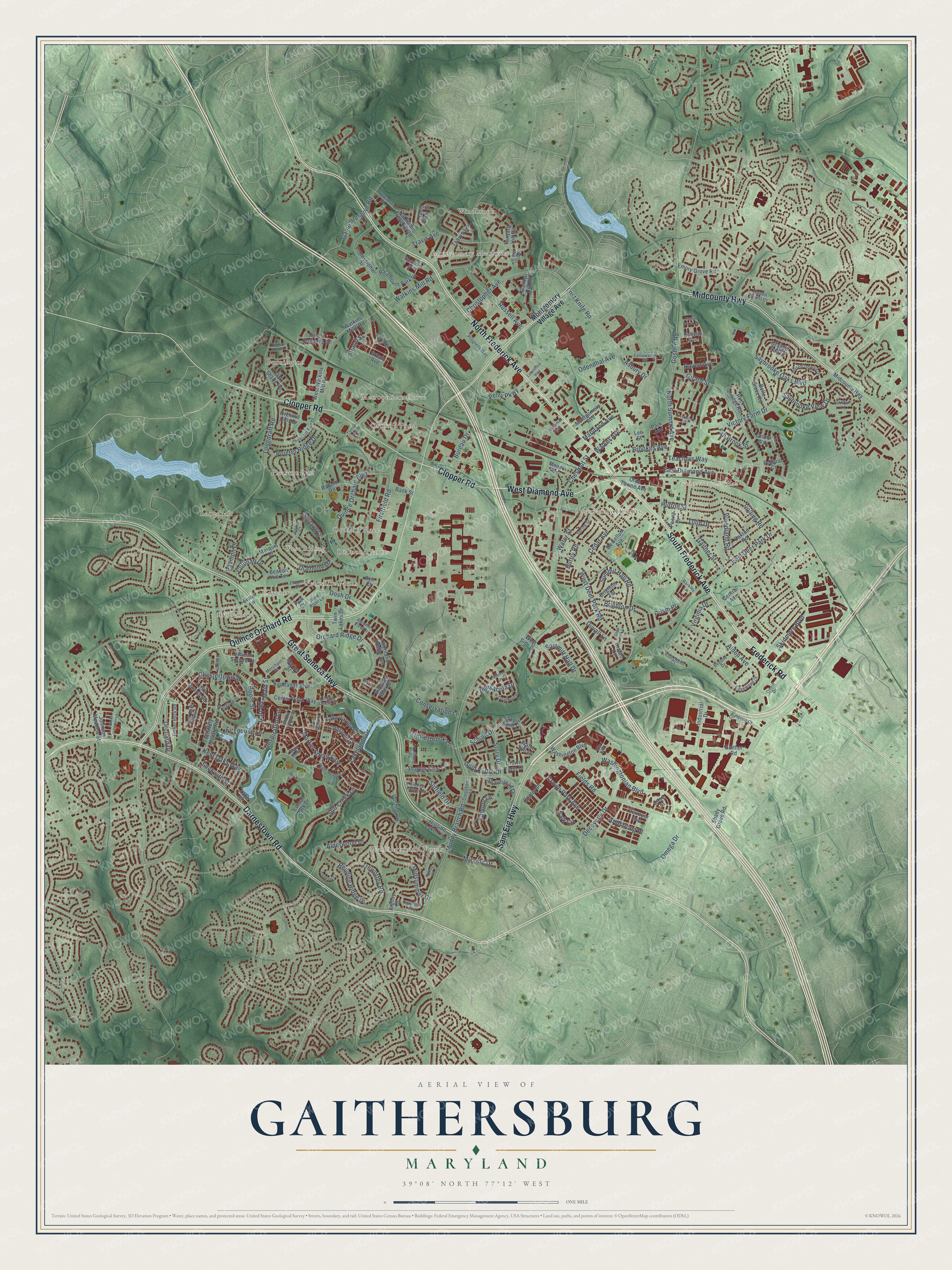
Gaithersburg, Maryland Map Art
Building by building, with labeled streets and shaded relief.
12" x 18" Archival Matte Print
A Map of Home. A Work of Art.
Explore Gaithersburg, Maryland from a whole new perspective. Created using aerial imagery and detailed geographic data, this map captures Gaithersburg building by building, with labeled streets, familiar landmarks, and shaded topographical relief that highlights the natural contours of the landscape.
Combining modern data with the timeless character of a vintage atlas, this map is just as interesting up close as it is beautiful on the wall. Whether you grew up in Gaithersburg, spent memorable years there, or call it home today, this unique map is a great way to celebrate a place that means something to you. Zoom in on the preview to look for your street, and then order a print to put your memories on the wall.
Three ways to hang it

Unframed archival matte, a black wood frame or a white wood frame.
Up close
Geography Worth Displaying
This map was created using accurate cartographic data and authoritative geographic sources, including the U.S. Geological Survey and the Census Bureau. The map brings together terrain, waterways, roads, and building detail. The majority of the streets are labeled, houses are accurately depicted, and the topography is derived from government sources. Combining local data with carefully composed color and shading leads to this beautifully detailed Gaithersburg artwork for your wall.
Rather than simply showing street outlines, we’ve included as many of the street names as we could reasonably fit on the map while keeping their names legible. Zoom in on the high resolution preview to see exactly what’s on the map. We truly set out to create a statement piece for anyone who loves Gaithersburg. So whether it’s for you, or a gift for someone you love, we hope this map of Gaithersburg brings back fond memories.
Read the story behind this map of Gaithersburg, Maryland from 2026.

Find your street
Names on the Gaithersburg map
Every name below is printed on this map. Look for your street, your school, the park where you played, or the pond down the road.
Places and landmarks18
- Gaithersburg City Hall
- Bohrer Park
- Morris Park
- Longdraft
- Bennington
- Washingtonian Woods
- Diamond Farms
- Bridlewood
- Metropolitan Grove
- Fernshire Farms
- Pleasant Run
- Montgomery Meadows
Show all 18 places
- Observatory Heights
- Coventry
- Orchard Pond
- West Riding
- Orchard Place
- Windbrook
Streets and roads214
- North Frederick Avenue
- South Frederick Avenue
- West Diamond Avenue
- Darnestown Road
- Frederick Road
- Quince Orchard Road
- Great Seneca Highway
- Midcounty Highway
- Clopper Road
- Sam Eig Highway
- Fields Road
- Omega Drive
- Main Street
- Watkins Mill Road
- East Diamond Avenue
- Beckwith Street
- Muddy Branch Road
- Longdraft Road
- Russell Avenue
- Lost Knife Road
- West Deer Park Road
- Washingtonian Boulevard
- Firstfield Road
- Quince Orchard Boulevard
- Girard Street
- Perry Parkway
- Midsummer Drive
- Orchard Ridge Drive
- Odendhal Avenue
- Summit Hall Road
Show all 214 streets
- Kent Oaks Way
- Chestertown Street
- Diamond Drive
- Game Preserve Road
- Crown Park Avenue
- Travis Avenue
- Still Creek Lane
- Pointer Ridge Drive
- East Deer Park Drive
- Victory Farm Drive
- Goshen Road
- North Summit Avenue
- Hutton Street
- Woodland Road
- Teachers Way
- Suffield Drive
- Market Street East
- Cedar Avenue
- Duvall Lane
- Christopher Avenue
- Saybrooke Oaks Boulevard
- Rolling Road
- Tulip Drive
- Booth Street
- Summitt Hall Drive
- Redding Ridge Drive
- Alderwood Drive
- Inspiration Lane
- Treworthy Road
- Gold Kettle Drive
- Saybrooke View Drive
- Brighton Drive
- Water Street
- Lakelands Drive
- Brookes Avenue
- Firehouse Lane
- Dosh Drive
- Travis Lane
- School Drive
- Conservation Lane
- Chestnut Street
- Gaither Street
- Timberbrook Lane
- Raven Avenue
- Orchard Drive
- Skidmore Boulevard
- Bureau Drive
- Mission Drive
- Decoverly Drive
- Story Drive
- Pavilion Drive
- Pensacola Drive
- Maryland Avenue
- Cullinan Drive
- Buttry Road
- Armstrong Place
- Fall Brook Street
- Walker Avenue
- Prism Place
- Alden Avenue
- Asbury Drive
- Virginia Drive
- Hart Road
- Grand Street
- Lamont Lane
- Salk Circle
- Montgomery Village Avenue
- Watkins Mills Road
- Olde Towne Avenue
- West Watkins Mill Road
- Forest Preserve Drive
- Polk Court
- Beacon Square Court
- Upshire Circle
- Shady Grove Road
- Kentlands Boulevard
- Tschiffely Square Road
- Sioux Lane
- Emory Grove Road
- Little Quarry Road
- Rabbitt Road
- West Side Drive
- Highland Ridge Avenue
- Edison Park Drive
- Beacon Hill Terrace
- Sharpstead Lane
- Hillside Lake Terrace
- Paramount Park Drive
- Professional Drive
- Park Avenue
- Center Point Way
- Grange Hall Drive
- Argosy Drive
- Summer Walk Drive
- Oak Shade Road
- Oakton Road
- Solitaire Court
- Tanyard Hill Road
- Copley Place
- Twin Lakes Drive
- Lake Varuna Drive
- Apple Seed Lane
- Urban Avenue
- Meem Avenue
- Travis View Court
- Washington Boulevard
- Market Street
- Gatestone Street
- Shadow Glen Court
- Lake Street
- Montgomery Avenue
- Watch Hill Lane
- Belle Grove Road
- Old Game Preserve Road
- Central Avenue
- Pelican Avenue
- Liriope Place
- Orchard Hills Drive
- De Sellum Avenue
- Federal Court
- Bralan Court
- Gaither Road
- Gallop Hill Road
- Johnson Meadow Street
- Vermeer Avenue
- Rock Lodge Road
- Gloria Way
- Peony Drive
- Industrial Drive
- Marquis Drive
- Brighton Terrace
- Bank Street
- Crown Farm Drive
- Lee Street
- Case Street
- Rye Court
- Wye Mill Court
- Kent Oaks Mews
- Pheasant Run Drive
- Edgewood Drive
- Fellowship Circle
- Spring Street
- Chevy Chase Street
- Bristol Downs Drive
- Wind River Lane
- Thurgood Street
- Edgewood Court
- Main Mews
- Merchant Place
- Crossbow Lane
- Spectrum Avenue
- Timber Rock Road
- Autumn View Drive
- Flagler Drive
- Progress Way
- Hidden Forest Court
- Arrowsmith Court
- Fleece Flower Drive
- Comprint Court
- Oneill Drive
- Eugene Drive
- Dalamar Street
- Barkley Lane
- Jonker Court
- Rio Boulevard
- Flower Center Lane
- Bookham Lane
- Coral Reef Drive
- Hidden Marsh Street
- Market Street West
- Englefield Drive
- Bright Meadow Lane
- High Gables Drive
- Palmtree Drive
- Deer Park Lane
- Turnham Court
- Crestwood Drive
- Elmira Lane
- Kendrick Place
- Lakeforest Boulevard
- Twelve Oaks Drive
- Honey Brook Lane
- Cross Green Street
- Argosy Circle
Names are listed as they appear on the printed map. Zoom into the product photos to find them.
About Gaithersburg, Maryland
Gaithersburg is a city of 69,657 people in Montgomery County, northwest of Washington, D.C. It began in 1765 as a small farming settlement called Log Town, near today's Summit Hall, on a 1725 land grant to Ralph Crabb known as "Deer Park." Benjamin Gaither built his home on part of that land in 1802, and by the 1850s the people living here had stopped saying Log Town and called the place Gaithersburg.
The name became official in 1873, when the railroad came through and the new station was named Gaithersburg. The Baltimore and Ohio built that depot to a design by Ephraim Francis Baldwin, known for his Victorian stations across Maryland. Growth came quickly, and the town was incorporated on April 5, 1878. Stores, hotels, schools and churches were built, along with a mill and grain elevators, and most of them stood near the station. Gaithersburg stayed a farm town until the 1970s, though it became a city in 1968.
“Gaithersburg is increasing in trade and population faster than any other place in the county, and is attracting many business men from other parts.”
- The Forest OakIn 1851 a post office opened in Gaither's store. It was called Forest Oak, after a huge tree in town. The oak stood for 295 years until a rainstorm brought it down in 1997, and it lives on in the city's logo and on its flag.
- 10,000 Confederates in 1864After the Battle of Monocacy, more than 10,000 Confederate soldiers marched a day from Frederick along today's Route 355. On July 10, 1864, they camped here overnight, partly on the ground that is now Bohrer Park. The next day they pushed on toward Washington, but they failed to take the capital.
- Watching the Earth wobbleIn 1899 Gaithersburg was chosen as one of six stations around the world built to measure the wobble of the Earth on its polar axis. Its readings, joined with those from stations in Japan, Italy, Russia and the U.S., helped map the planet's size and shape. Observers worked here by hand until 1982, when computers took over. The observatory is the city's only National Historic Landmark.
Keep exploring Maryland
Gaithersburg is one of 881 Maryland towns we've mapped. Every dot on the map is a print of its own.
The search covers every state, Maryland first.
Near Gaithersburg
Order 2 or more town maps and save 10%. Shown in the size and finish you picked above, so they hang as a set.
- Washington Grove 12" x 18" / Archival Matte Print $39.99
- Flower Hill 12" x 18" / Archival Matte Print $39.99
- Rosemont 12" x 18" / Archival Matte Print $39.99


More maps nearby: Watkins Mill, Clopper, Goshen, Montgomery Village and Redland.
The art of mapping a place
How This Map Was Made
Real places. Remarkable detail. Discover the layers that turn geographic data into a map of home.

The view from above
Aerial imagery reveals the character of the land: woodland, open fields, and the patterns of a place.

The shape of the land
Elevation data brings hills, valleys, and subtle changes in the landscape into view.

The details of home
Roads, waterways, and building footprints come together to make the map feel unmistakably local.

Geography becomes art
Considered color, shading, and typography bring the layers together in a map made for your wall.


Process illustrated with Mendon, Massachusetts. Aerial imagery: USDA NAIP. Terrain: USGS 3D Elevation Program. Map details and finished artwork: KNOWOL.
The Details
About This Print
Choose an archival matte print, or a black or white Ayous wood frame. The archival matte print is unframed.
Select your size and finish above to see the matching product image and price.
Materials & Craftsmanship
A contemporary map with the character of a classic atlas, printed on archival matte paper. Optional frames are made from Ayous wood.
Your printed map does not include the watermark shown in the full-map preview.
Shipping & Delivery
Free shipping within the United States. Every print is made to order in the USA.
Buying a gift? Add a note in your cart and we'll include it. We never put prices in the package.
Prints ship within 2 to 3 business days. Allow 7 to 10 days total from ordering for delivery. Timing may vary during holidays or periods of high order volume.
Read our shipping policy.
Returns and damaged prints
Each print is made to order. Change-of-mind refunds are not available after production.
If your print arrives damaged, misprinted or incorrect, contact support@knowol.com within 30 days of receiving it. Include your order number, photos and a description of the issue.
Read our full refund and replacement policy. For questions about your order, email support@knowol.com.