


Search for another town


Free U.S. delivery 7 to 10 days after you order
Watkins Mill, Maryland Map Art
Building by building, with labeled streets and shaded relief.
12" x 18" Archival Matte Print
A Map of Home. A Work of Art.
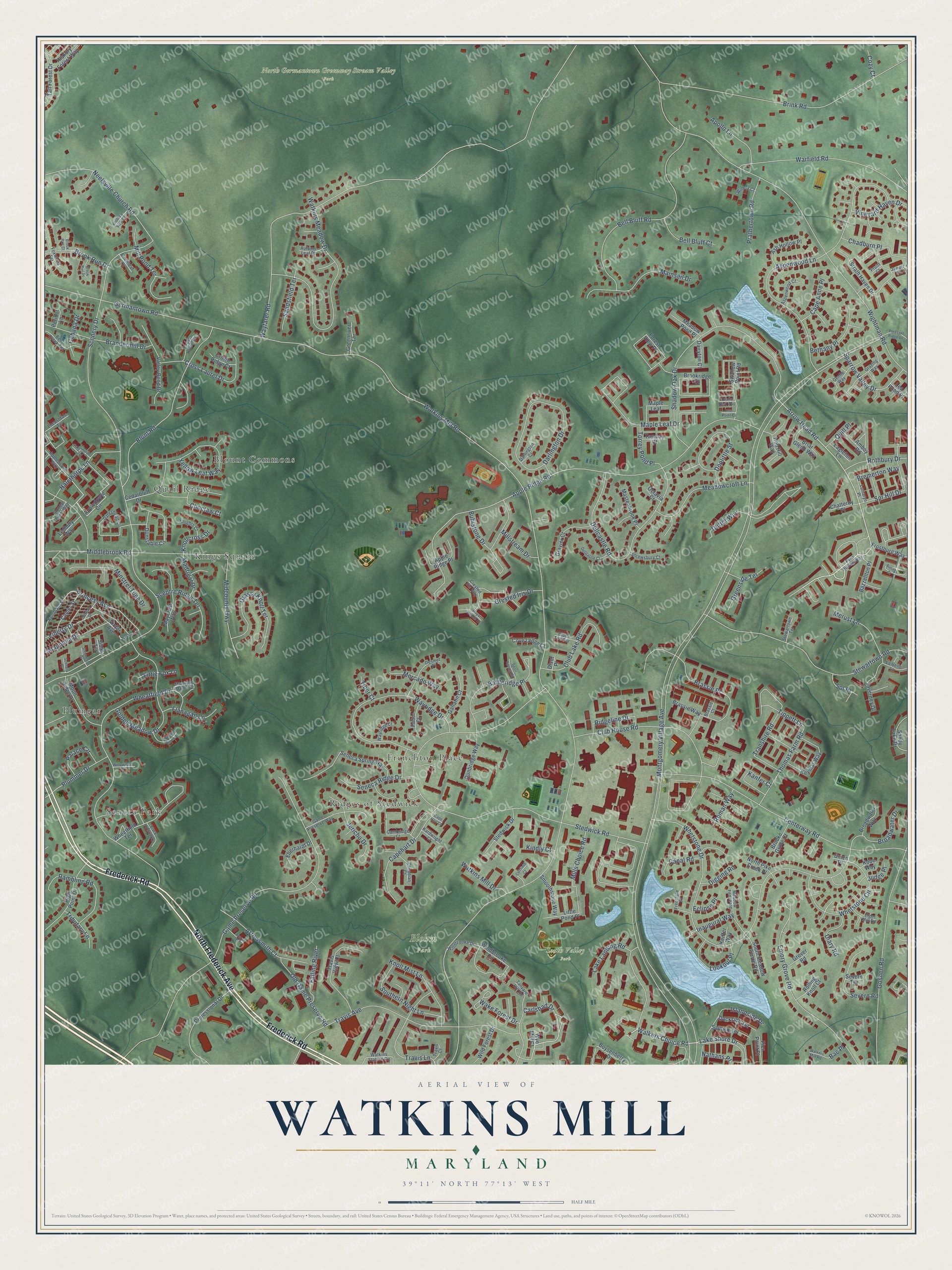
Explore Watkins Mill, Maryland from a whole new perspective. Created using aerial imagery and detailed geographic data, this map captures Watkins Mill building by building, with labeled streets, familiar landmarks, and shaded topographical relief that highlights the natural contours of the landscape.
Combining modern data with the timeless character of a vintage atlas, this map is just as interesting up close as it is beautiful on the wall. Whether you grew up in Watkins Mill, spent memorable years there, or call it home today, this unique map is a great way to celebrate a place that means something to you. Zoom in on the preview to look for your street, and then order a print to put your memories on the wall.
Three ways to hang it

Unframed archival matte, a black wood frame or a white wood frame.
Up close
Geography Worth Displaying
This map was created using accurate cartographic data and authoritative geographic sources, including the U.S. Geological Survey and the Census Bureau. The map brings together terrain, waterways, roads, and building detail. The majority of the streets are labeled, houses are accurately depicted, and the topography is derived from government sources. Combining local data with carefully composed color and shading leads to this beautifully detailed Watkins Mill artwork for your wall.
Rather than simply showing street outlines, we’ve included as many of the street names as we could reasonably fit on the map while keeping their names legible. Zoom in on the high resolution preview to see exactly what’s on the map. We truly set out to create a statement piece for anyone who loves Watkins Mill. So whether it’s for you, or a gift for someone you love, we hope this map of Watkins Mill brings back fond memories.
Read the story behind this map: Detailed Map of Watkins Mill, Maryland.

Find your street
Names on the Watkins Mill map
Every name below is printed on this map. Look for your street, your school, the park where you played, or the pond down the road.
Places and landmarks10
- Blohm Park
- North Germantown Greenway Stream Valley Park
- South Valley Park
- Blount Commons
- Plumgar
- Frenchton Place
- Kings Square
- Seneca Park
- Ridges of Stedwick
- Quail Ridge
Streets and roads256
- North Frederick Avenue
- Frederick Road
- Walkers Choice Road
- Lake Shore Drive
- Arrow Head Road
- Carlsbad Drive
- Princess Avenue
- Montgomery Village Avenue
- Watkins Mill Road
- Scenery Drive
- Stedwick Road
- Apple Ridge Road
- Game Preserve Road
- Wightman Road
- Wayfarer Road
- Whetstone Drive
- Blunt Road
- Wheatfield Drive
- Brink Road
- Aspenwood Lane
- Stewartown Road
- Centerway Road
- Shadow Oak Drive
- Watkins Meadow Drive
- Travis Avenue
- Germantown Road
- Bell Bluff Road
- Goshen Road
- Dellcastle Road
- Wayridge Drive
Show all 256 streets
- Darlington Drive
- Brandermill Drive
- Emory Grove Road
- Duffer Way
- Maple Leaf Drive
- Middlebrook Road
- Warfield Road
- Club House Road
- Golden Meadow Drive
- Brassie Place
- Neelsville Church Road
- Transhire Road
- Whetstone Circle
- Battleridge Place
- Yellow Leaf Way
- Grassy Knoll Terrace
- Doolittle Street
- Capehart Drive
- Travis Lane
- Mainsail Drive
- Meadowcroft Lane
- Cross Laurel Drive
- Midcounty Highway
- Arrowsmith Court
- Rambling Road
- Club Lake Road
- Southern Night Lane
- Mill Pond Terrace
- Minstrel Tune Drive
- Knoll Mist Lane
- Mills Choice Road
- Thomas Farm Road
- Sparrow Valley Drive
- Halethorpe Lane
- Severn Road
- Islandside Drive
- Old Game Preserve Road
- Choctaw Court
- Sceptre Ridge Terrace
- Spr Hill Drive
- Broadwater Drive
- Seneca Ridge Drive
- Jericho Drive
- Plummer Drive
- Lookout Place
- Chadburn Place
- Liberty Drive
- Magnolia Drive
- Merust Lane
- Prathertown Road
- Brook Run Drive
- Crested Iris Drive
- Bethany Place
- Rothbury Drive
- Apollo Lane
- Ridgeline Drive
- Bell Bluff Court
- Sandsfield Terrace
- Greenside Terrace
- Kanfer Court
- Vineyard Haven Drive
- Falling River
- Flanagan Lane
- Palace Circle
- Torrey Pond Place
- Watkins Mill Drive
- Diary Road
- Lake Landing Road
- Mercado Way
- Tippett Lane
- Cape Anne Place
- Sol Place
- Millstream Drive
- Canal Road
- Tributary Lane
- Madrigal Drive
- Wake Forest Drive
- Cabana Drive
- Buhrstone Drive
- Bremerton Way
- Little Fox Lane
- Inaugural Way
- Knollcross Drive
- Digging Road
- Roman Way
- Quill Place
- Nathans Place
- Kindly Court
- Eclipse Place
- Cozy Court
- Judge Place
- Tiber Court
- Bac Place
- Wye Mill Court
- Victor Avenue
- Appledowre Circle
- Wheatfield Terrace
- Forest View Place
- Seneca Spring Way
- Strath Haven Drive
- Professional Drive
- Swallow Point Road
- Brookridge Court
- Windbrooke Circle
- Travis View Court
- Dunstable Circle
- High Point Drive
- Maycrest Way
- Valley Bend Drive
- Keymar Way
- Stedwick Drive
- Moon Ridge Drive
- Cedarbluff Drive
- Hob Hill Way
- Taverney Drive
- Boysenberry Drive
- Apple Ridge Place
- Gravier Court
- Tall Forest Drive
- Dairyton Court
- Dunbridge Way
- Gallatin Court
- Ash Hollow Place
- Comer Street
- South Meadow Fence Road
- Smoothstone Way
- Sandy Lake Drive
- Briar Glenn Way
- Bazzellton Place
- Mastenbrook Place
- Dockside Terrace
- Wild Forest Drive
- Sailfish Terrace
- Frostburg Way
- Eberhardt Drive
- Little Pond Place
- Hickory Forest Way
- Meadow Pond Place
- Grover Road
- Cove Ledge Court
- Broadwater Way
- Brooke Grove Court
- Greenriver Terrace
- Amboy Road
- Brassie Way
- Rolling Knoll Court
- Faber Court
- Crown Ridge Court
- Ledbury Way
- Chatteroy Place
- North Pike Creek Place
- Pier Point Place
- Eagleton Lane
- Tambay Court
- Lea Pond Place
- Maple Leaf
- Keiffer Way
- Peridot Lane
- Octavia Court
- Kobe Way
- Severn Terrace
- Sibley Terrace
- Divot Place
- Union Place
- Fern Hollow Way
- Tanyard Hill Road
- Gateshead Circle
- Cambridge Court
- Desmet Place
- Grazing Way
- Meadow Fence Road
- Canadian Court
- Foxwood Terrace
- Rembrant Street
- Watkins Station Circle
- Bent Creek Terrace
- Maryland Manor Court
- Appledowre Way
- Gentle Way
- Elger Mill Road
- Windbrooke Drive
- Crested Iris Way
- Aspenwood Court
- Freestate Place
- Shrewsbury Court
- Game Preserve Way
- Stoney Point Way
- Locustdale Terrace
- Wayridge Court
- Cross Laurel Court
- Knights Court
- Stewartown Terrace
- La Belle Lane
- Autumn Leaf Place
- Lumaryn Place
- Kardwright Court
- Darlington Court
- Blue Tee Terrace
- Arrowleaf Court
- Winery Court
- Jarrett Court
- Travis Court
- Brassie Court
- Pruitt Court
- Nashua Drive
- Billings Court
- Dellcastle Court
- Winding Brook Lane
- Pleasant Ridge Drive
- Black Forest Way
- Coltfield Court
- Royal Woods Court
- Sparr Spring Road
- Ararat Drive
- Halethorpe Terrace
- Brook Run Place
- Knolltop View Court
- Willowdale Drive
- Garway Street
- Walkers Mill Road
- Stevenson Drive
- Quails Nest Way
- Cape Hart Court
- Inlet Point Court
- Scenery Place
- Brook Run Court
Names are listed as they appear on the printed map. Zoom into the product photos to find them.
Keep exploring Maryland
Watkins Mill is one of 881 Maryland towns we've mapped. Every dot on the map is a print of its own.
The search covers every state, Maryland first.
Near Watkins Mill
Order 2 or more town maps and save 10%. Shown in the size and finish you picked above, so they hang as a set.
- Montgomery Village 12" x 18" / Archival Matte Print $39.99
- Goshen 12" x 18" / Archival Matte Print $39.99
- Flower Hill 12" x 18" / Archival Matte Print $39.99

More maps nearby: Gaithersburg, Clopper, Germantown, Washington Grove and Clarksburg.
The art of mapping a place
How This Map Was Made
Real places. Remarkable detail. Discover the layers that turn geographic data into a map of home.

The view from above
Aerial imagery reveals the character of the land: woodland, open fields, and the patterns of a place.

The shape of the land
Elevation data brings hills, valleys, and subtle changes in the landscape into view.

The details of home
Roads, waterways, and building footprints come together to make the map feel unmistakably local.

Geography becomes art
Considered color, shading, and typography bring the layers together in a map made for your wall.


Process illustrated with Mendon, Massachusetts. Aerial imagery: USDA NAIP. Terrain: USGS 3D Elevation Program. Map details and finished artwork: KNOWOL.
The Details
About This Print
Choose an archival matte print, or a black or white Ayous wood frame. The archival matte print is unframed.
Select your size and finish above to see the matching product image and price.
Materials & Craftsmanship
A contemporary map with the character of a classic atlas, printed on archival matte paper. Optional frames are made from Ayous wood.
Your printed map does not include the watermark shown in the full-map preview.
Shipping & Delivery
Free shipping within the United States. Every print is made to order in the USA.
Buying a gift? Add a note in your cart and we'll include it. We never put prices in the package.
Prints ship within 2 to 3 business days. Allow 7 to 10 days total from ordering for delivery. Timing may vary during holidays or periods of high order volume.
Read our shipping policy.
Returns and damaged prints
Each print is made to order. Change-of-mind refunds are not available after production.
If your print arrives damaged, misprinted or incorrect, contact support@knowol.com within 30 days of receiving it. Include your order number, photos and a description of the issue.
Read our full refund and replacement policy. For questions about your order, email support@knowol.com.