


Search for another town


Free U.S. delivery 7 to 10 days after you order
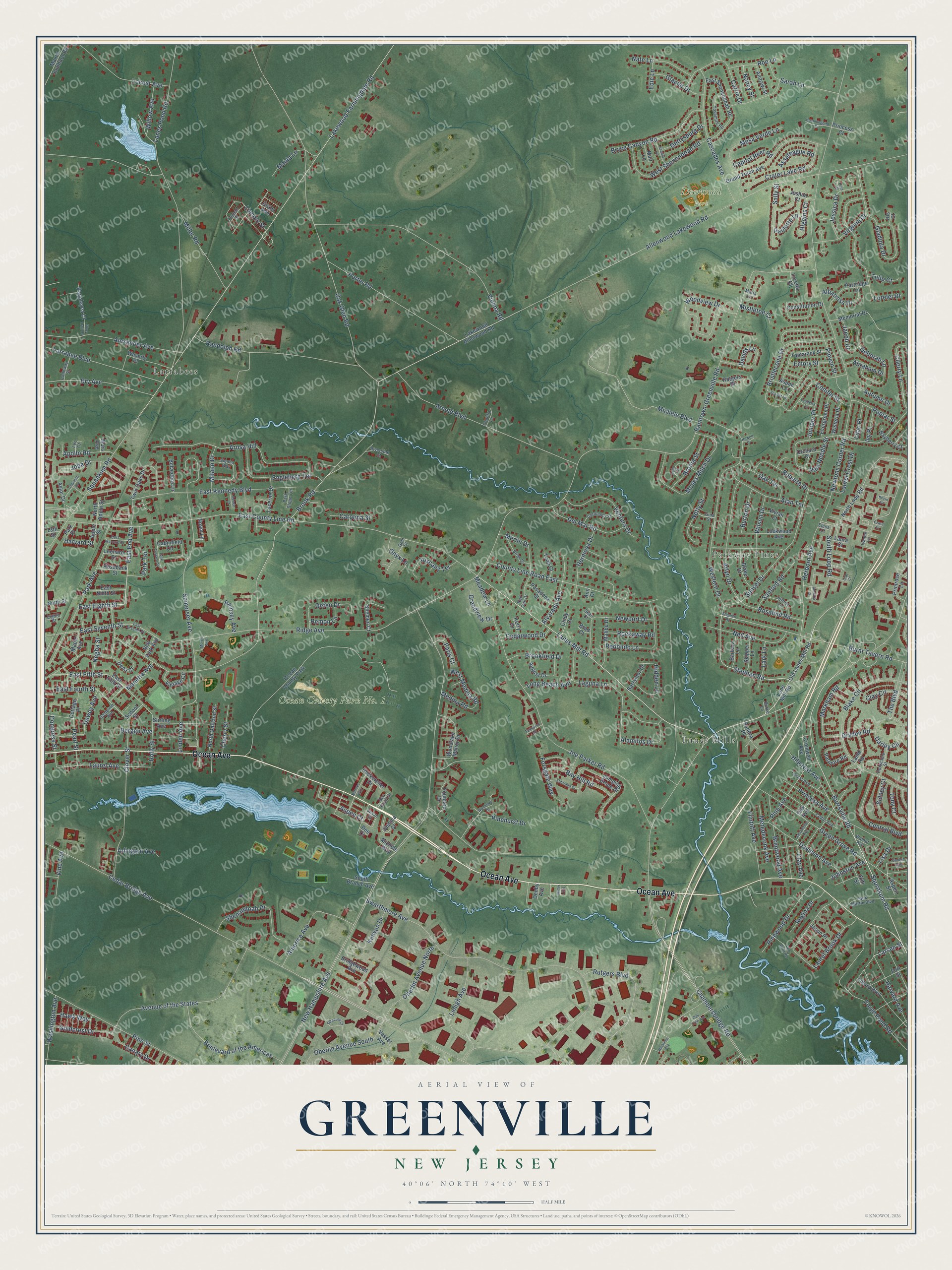
Greenville, New Jersey Map Art
Building by building, with labeled streets and shaded relief.
12" x 18" Archival Matte Print
A Map of Home. A Work of Art.
Explore Greenville, New Jersey from a whole new perspective. Created using aerial imagery and detailed geographic data, this map captures Greenville building by building, with labeled streets, familiar landmarks, and shaded topographical relief that highlights the natural contours of the landscape.
Combining modern data with the timeless character of a vintage atlas, this map is just as interesting up close as it is beautiful on the wall. Whether you grew up in Greenville, spent memorable years there, or call it home today, this unique map is a great way to celebrate a place that means something to you. Zoom in on the preview to look for your street, and then order a print to put your memories on the wall.
Three ways to hang it

Unframed archival matte, a black wood frame or a white wood frame.
Up close
Geography Worth Displaying
This map was created using accurate cartographic data and authoritative geographic sources, including the U.S. Geological Survey and the Census Bureau. The map brings together terrain, waterways, roads, and building detail. The majority of the streets are labeled, houses are accurately depicted, and the topography is derived from government sources. Combining local data with carefully composed color and shading leads to this beautifully detailed Greenville artwork for your wall.
Rather than simply showing street outlines, we’ve included as many of the street names as we could reasonably fit on the map while keeping their names legible. Zoom in on the high resolution preview to see exactly what’s on the map. We truly set out to create a statement piece for anyone who loves Greenville. So whether it’s for you, or a gift for someone you love, we hope this map of Greenville brings back fond memories.
Read the story behind this map: Detailed Map of Greenville, New Jersey.

Find your street
Names on the Greenville map
Every name below is printed on this map. Look for your street, your school, the park where you played, or the pond down the road.
Places and landmarks6
- Deerwood Park
- Ocean County Park No. 1
- Parkway Pines
- Larrabees
- Lanes Mills
- Ocean County Park
Streets and roads335
- Ocean Avenue
- Lanes Mill Road
- Burrsville Road
- Stephan Road
- East End Avenue
- Allenwood Lakewood Road
- Larsen Street
- Brook Road
- Squrnkum Road
- Cedar Bridge Avenue
- New Hampshire Avenue
- Ridge Avenue
- Newtons Corner Road
- Lakewood Farmingdale Road
- East County Line Road
- Swarthmore Avenue
- Chambersbridge Road
- Ramtown-Greenville Road
- Oak Glen Road
- Lanes Pond Road
- East Kennedy Boulevard
- Somerset Avenue
- Joe Parker Road
- Western Drive
- Vienna Road
- East Seventh Street
- Arnold Boulevard
- Pine Needle Street
- Burnt Tavern Road
- Michele Boulevard
Show all 335 streets
- Blake Circle
- Park Avenue
- Rutgers Boulevard
- Arosa Hill
- Bristlecone Drive
- Avenue of the States
- Randolph Road
- County Line Road East
- Green Grove Road
- Squankum Road
- Pine Street
- Laurel Brook Drive
- Clover Street
- Forge Pond Road
- Porter Road
- Sunset Drive
- Lorelei Drive
- Moses Milch Drive
- Cascades Avenue
- Alexander Avenue
- Woodview Drive
- Boulevard of the Americas
- Arlyn Drive
- Princess Avenue
- Pinehurst Drive
- Larrabee Boulevard
- The Boulevard
- East Fifth Street
- Pinyon Street
- Deborah Lane
- Virginia Drive
- Bry Avenue
- West Shenendoah Road
- Laurel Avenue
- Gladiola Drive
- Lehigh Avenue
- America Avenue
- Bryce Canyon Road
- Laguna Lane
- Engleberg Terrace
- Herborn Avenue
- Locust Avenue
- Davidson Avenue
- Shenandoah Drive
- Newport Drive
- Oberlin Avenue South
- Pine Avenue
- Alamitos Drive
- Carrie Drive
- Ventura Drive
- East Fourth Street
- Central Boulevard
- Redondo Lane
- Oberlin Avenue North
- Miller Road
- Roberta Drive
- Conifer Street
- Crater Lake Road
- Darley Circle
- Alan Terrace
- Pinewood Drive
- Mesa Verde Lane
- Neil Avenue
- Long Beach Avenue
- Wilson Drive
- Aspen Court
- Sarah Lane
- Clay Circle
- Flintoft Avenue
- Del Mar Road
- Harvard Avenue
- Davids Lane
- South Loop Road
- Markham Road
- Brentwood Avenue
- Hidden Lane
- Gefen Drive
- Bay Hill Road
- Jessica Drive
- Cherry Lane
- Washington Avenue
- Rosalind Road
- Nate Lane
- Tuscany Terrace
- Bronia Street
- Laurel Crest Drive
- Lincoln Street
- Joda Drive
- Goldcrest Drive
- Apollo Road
- Linden Avenue
- Merlin Drive
- Hermosa Drive
- Oak Terrace
- Sanford Road
- Sally Street
- Manetta Avenue
- Higgins Court
- Netty Street
- Maida Lane
- Forsgate Way
- Metedeconk Avenue
- Glacier Drive
- Brookfield Drive
- Albatross Drive
- Jacob Drive
- Regina Drive
- Juniper Place
- Vine Avenue
- West Medina Road
- Gettysburg Drive
- Cedarwood Drive
- Holly Street
- Negba Street
- Roe Lane
- Willow Avenue
- Poplar Street
- Canary Drive
- Bergen Avenue
- Cherry Street
- Rockaway Road
- Assateague Road
- Lark Lane
- Onyx Lane
- Ramsey Avenue
- Alvarado Avenue
- Pearl Street
- East Eighth Street
- Milano Drive
- Dewey Avenue
- Burton Drive
- Autumn Drive
- Arlington Avenue
- Capitol Reef Road
- Abraham Drive
- Grandview Drive
- Emory Street
- Johnston Avenue
- Tony Court
- Hillcrest Avenue
- Park Terrace
- Remon Lane
- Carolina Street
- Mistletoe Court
- Medina Road
- Hawk Way
- Paulette Lane
- Paris Court
- Congress Street
- Lilac Place
- Meadow Lane
- Kenyon Drive
- Nancy Street
- Sidney Court
- Dryden Road
- Clay Avenue
- Tulip Court
- Ivy Place
- Harvard Street
- Edie Lane
- Lisa Drive
- Old Lanes Mill Road
- Lane Mill Road
- Twin Oaks Drive
- Lakewood Allenwood Road
- North Loop Road
- Grand Teton Avenue
- Jumping Brook Drive
- East Shenendoah Road
- Memorial Drive
- Woodlake Manor Drive
- Tilford Boulevard
- Lockwood Avenue
- Cabinfield Circle
- Tamarack Street
- Stirling Avenue
- Orchard Court
- August Drive
- Patmore Road
- North Oakland Street
- Malibu Drive
- Primrose Lane
- Waverly Place
- Shemen Court
- Evergreen Place
- Maxim Southard Road
- Blake Drive
- Oak Avenue
- Fort Street
- Lucerne Drive
- Jessica Court
- East Ninth Street
- Grant Avenue
- Vintage Circle
- Fountain Drive
- Sandra Place
- Vasser Avenue
- Vivian Court
- Astor Drive
- Pasadena Street
- Constitution Drive
- Rappleyea Court
- Partridge Lane
- Bayberry Court
- Wisteria Place
- Skipper Lane
- Dena Court
- Barbara Lane
- Andrew Street
- Cindy Court
- South Branch Avenue
- Elm Street
- Belvedere Lane
- Rutgers Drive
- Bridgewood Avenue
- Lamb Road
- Barrymor Drive
- Cromwell Avenue
- Rosebank Street
- Noam Lane
- Cottage Place
- Laura Court
- Jason Place
- Joshua Court
- Rockefeller Drive
- Todd Court
- Maple Avenue
- Princess Court
- North Apple Street
- Leonard Street
- Aspen Lane
- Park Place
- Michele Way
- Ninth Street
- Loretta Court
- New York Avenue
- School Street
- Aspen Street
- Muir Lane
- Apple Street
- Kerry Court
- Denby Avenue
- 13th Street
- Dee Court
- Brad Court
- Iris Court
- Mars Avenue
- Ann Court
- Walnut Avenue
- Cedar Avenue
- Forest Avenue
- Jack Martin Boulevard
- Sienna Way
- Yosemite Road
- Coronado Street
- Brian Street
- Gem Drive
- Red Oak Drive
- Jeffrey Lane
- Susan Drive
- Truman Street
- Constable Street
- Sampson Avenue
- Calloway Street
- Riverside Court
- Park Slope Terrace
- Gina Street
- Sea Point Drive
- Country Lane
- Leo Court
- Eighth Street
- Ivanna Lane
- Elena Court
- Burke Lane
- Maria Lane
- Sean Court
- Stephen Road
- Adriana Court
- Syracuse Court
- Garden Avenue
- Fella Street
- Eldorado Drive
- East Harvard Street
- Woodlake Drive
- Red Bluff Road
- Kevin Court
- Coleman Avenue
- Park Terrace Street
- Acadia Lane
- Hummingbird Court
- Oak Tree Avenue
- Natures Way
- Jacqueline Avenue
- Morris Avenue
- Scarlet Lane
- Tamarind Road
- Teaberry Lane
- Renee Court
- Herkimer Avenue
- Blue Trail Road
- Howell Court
- Miller Avenue
- Ezara Court
- Lynn Court
- Lido Court
Names are listed as they appear on the printed map. Zoom into the product photos to find them.
Keep exploring New Jersey
Greenville is one of 990 New Jersey towns we've mapped. Every dot on the map is a print of its own.
The search covers every state, New Jersey first.
Near Greenville
Order 2 or more town maps and save 10%. Shown in the size and finish you picked above, so they hang as a set.
- Ramtown 12" x 18" / Archival Matte Print $39.99
- Lakewood 12" x 18" / Archival Matte Print $39.99
- Herbertsville 12" x 18" / Archival Matte Print $39.99


More maps nearby: Leisure Village, Leisure Village East, Brick, Allenwood and Lake Riviera.
The art of mapping a place
How This Map Was Made
Real places. Remarkable detail. Discover the layers that turn geographic data into a map of home.

The view from above
Aerial imagery reveals the character of the land: woodland, open fields, and the patterns of a place.

The shape of the land
Elevation data brings hills, valleys, and subtle changes in the landscape into view.

The details of home
Roads, waterways, and building footprints come together to make the map feel unmistakably local.

Geography becomes art
Considered color, shading, and typography bring the layers together in a map made for your wall.


Process illustrated with Mendon, Massachusetts. Aerial imagery: USDA NAIP. Terrain: USGS 3D Elevation Program. Map details and finished artwork: KNOWOL.
The Details
About This Print
Choose an archival matte print, or a black or white Ayous wood frame. The archival matte print is unframed.
Select your size and finish above to see the matching product image and price.
Materials & Craftsmanship
A contemporary map with the character of a classic atlas, printed on archival matte paper. Optional frames are made from Ayous wood.
Your printed map does not include the watermark shown in the full-map preview.
Shipping & Delivery
Free shipping within the United States. Every print is made to order in the USA.
Buying a gift? Add a note in your cart and we'll include it. We never put prices in the package.
Prints ship within 2 to 3 business days. Allow 7 to 10 days total from ordering for delivery. Timing may vary during holidays or periods of high order volume.
Read our shipping policy.
Returns and damaged prints
Each print is made to order. Change-of-mind refunds are not available after production.
If your print arrives damaged, misprinted or incorrect, contact support@knowol.com within 30 days of receiving it. Include your order number, photos and a description of the issue.
Read our full refund and replacement policy. For questions about your order, email support@knowol.com.