
Search for another town


Free U.S. delivery 7 to 10 days after you order
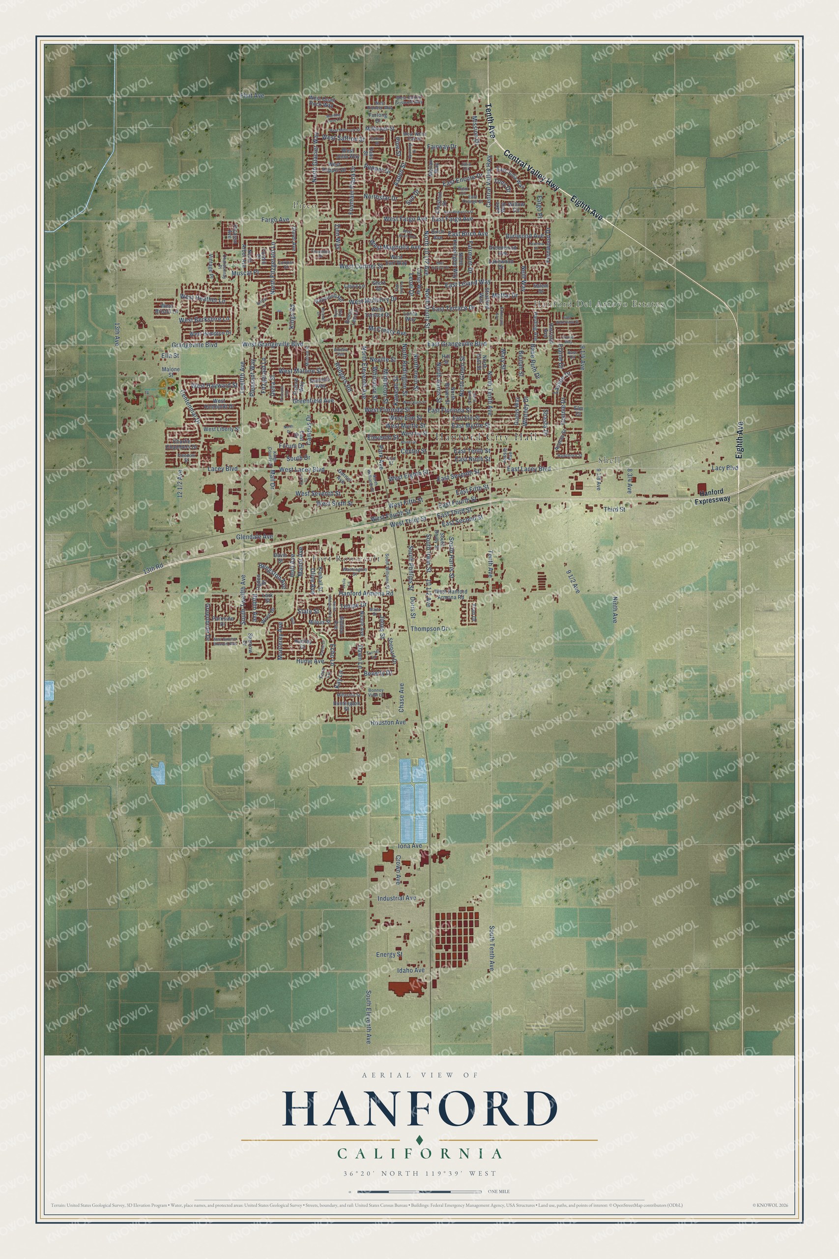
Hanford, California Map Art
Building by building, with labeled streets and shaded relief.
12" x 18" Archival Matte Print
A Map of Home. A Work of Art.
Explore Hanford, California from a whole new perspective. Created using aerial imagery and detailed geographic data, this map captures Hanford building by building, with labeled streets, familiar landmarks, and shaded topographical relief that highlights the natural contours of the landscape.
Combining modern data with the timeless character of a vintage atlas, this map is just as interesting up close as it is beautiful on the wall. Whether you grew up in Hanford, spent memorable years there, or call it home today, this unique map is a great way to celebrate a place that means something to you. Zoom in on the preview to look for your street, and then order a print to put your memories on the wall.
Three ways to hang it

Unframed archival matte, a black wood frame or a white wood frame.
Up close
Geography Worth Displaying
This map was created using accurate cartographic data and authoritative geographic sources, including the U.S. Geological Survey and the Census Bureau. The map brings together terrain, waterways, roads, and building detail. The majority of the streets are labeled, houses are accurately depicted, and the topography is derived from government sources. Combining local data with carefully composed color and shading leads to this beautifully detailed Hanford artwork for your wall.
Rather than simply showing street outlines, we’ve included as many of the street names as we could reasonably fit on the map while keeping their names legible. Zoom in on the high resolution preview to see exactly what’s on the map. We truly set out to create a statement piece for anyone who loves Hanford. So whether it’s for you, or a gift for someone you love, we hope this map of Hanford brings back fond memories.
Read the story behind this map of Hanford, California from 2026.

Find your street
Names on the Hanford map
Every name below is printed on this map. Look for your street, your school, the park where you played, or the pond down the road.
Places and landmarks5
- Hanford City Hall
- Pitco
- Hanford Del Arroyo Estates
- Shell
- Fort Roosevelt
Streets and roads253
- Eighth Avenue
- Central Valley Highway
- Tenth Avenue
- North Douty Street
- North Tenth Avenue
- West Seventh Street
- East Seventh Street
- South Tenth Avenue
- West Grangeville Boulevard
- East Grangeville Boulevard
- Neill Way
- East Terrace Drive
- Grangeville Boulevard
- Fairway Drive
- Twelfth Avenue
- Hanford Armona Road
- West Sixth Street
- Fountain Plaza Drive
- East Fargo Avenue
- East Encore Drive
- South Twelfth Avenue
- Whitney Drive
- Dawn Lane
- Manor Avenue
- East Fifth Street
- Zion Way
- Holt Avenue
- North Eleventh Avenue
- South Eleventh Avenue
- West Lacey Boulevard
Show all 253 streets
- Greenfield Avenue
- Fargo Avenue
- East Florinda Street
- Rodgers Road
- East Leland Way
- Houston Avenue
- East Lacey Boulevard
- Aspen Street
- West Cortner Street
- Lacey Boulevard
- 13th Avenue
- Centennial Drive
- West Fargo Avenue
- North Fitzgerald Lane
- North Redington Street
- North Glacier Way
- Fairmont Drive
- Glendale Avenue
- Flint Avenue
- Hume Avenue
- East Myrtle Street
- East Third Street
- North Irwin Street
- North Harris Street
- Mall Drive
- Campus Drive
- Iona Avenue
- West Florinda Street
- Kaweah Street
- Idaho Avenue
- West Malone Street
- South Irwin Street
- Leoni Drive
- McCreary Avenue
- South Phillips Street
- Ninth Avenue
- North Green Street
- South Harris Street
- Third Street
- Lassen Drive
- West Fifth Street
- Muscat Place
- East Tenth Street
- West Eighth Street
- Neville Street
- Thompson Drive
- West Mulberry Drive
- Eleventh Street
- West Third Street
- West Fourth Street
- Jones Street
- Pine Street
- Pleasant Way
- Kings Road
- Whitmore Street
- Mission Drive
- Middleton Street
- Greenbrier Drive
- West Elm Street
- East Birch Avenue
- East Fourth Street
- East Ninth Street
- Northstar Drive
- Fernwood Drive
- Moffat Drive
- Park Avenue
- Tempe Drive
- West Magnolia Avenue
- Echo Lane
- Beverly Drive
- Mary Street
- West Hayward Street
- Fitzgerald Lane
- West Berkshire Lane
- East Second Street
- West Heather Lane
- Crown Avenue
- Babe Ruth Drive
- West Saffron Street
- Beulah Street
- Industrial Avenue
- West Myrtle Street
- Burlwood Avenue
- 13th Road
- Bengston Avenue
- Chase Avenue
- Kay Lane
- Monterey Avenue
- Connie Drive
- Pepper Drive
- Olive Avenue
- Forum Drive
- Energy Street
- Doris Street
- Robin Avenue
- Elaine Drive
- Center Street
- South Drive
- Della Street
- Lacy Boulevard
- Shasta Drive
- Fargo Place
- Tony Drive
- State Street
- Sun Drive
- Ella Street
- Hanford Expressway
- Garner Avenue
- West Hanford Armona Road
- West Quail Rock Way
- Oaks Street
- West Pepper Drive
- Galileo Avenue
- North Kensington Way
- North Brown Street
- Davis Street
- East Elm Street
- South Douty Street
- Emma Lee Lane
- Carter Way
- West Terrace Drive
- West Liberty Street
- North East Street
- West Julia Way
- Harrison Avenue
- West Ivy Street
- East Julia Way
- Short Drive
- Stratford Way
- Birch Avenue
- West Bristol Lane
- Lakewood Drive
- Oxford Way
- Kimball Street
- Chestnut Street
- West Humboldt Drive
- Claret Avenue
- West Hampton Drive
- Parkside Drive
- West Earl Way
- North Arbor Avenue
- Lark Street
- Hartley Drive
- Shepard Drive
- Sparrow Drive
- Charlie Chambers Drive
- Wren Drive
- Harding Avenue
- Gladys Way
- Nicole Avenue
- Greenwood Avenue
- Raymond Road
- Millbrook Street
- Huntington Street
- Dominic Way
- East Drive
- Lorita Way
- Jessie Avenue
- Ogden Street
- Acacia Street
- Vintage Place
- Picasso Avenue
- Merlan Way
- Salem Drive
- Milpas Street
- Furlong Drive
- Hill Street
- Fern Lane
- Laura Lane
- Malone Street
- Lake Way
- Elm Court
- Fran Drive
- Foxhill Place
- Willow Circle
- South Williams Street
- Chardonnay Place
- West Harold Griswold Way
- North Williams Street
- East Orange Street
- West Pioneer Way
- Washington Street
- Amelia Avenue
- Yosemite Drive
- West White Oak Drive
- Mildred Street
- Hawthorn Street
- Kings County Drive
- Millerton Street
- Malta Street
- Freedom Street
- Turner Lane
- Cortner Street
- Julia Circle
- Bonney View Lane
- Ford Street
- Palm Circle
- Bass Circle
- North White Street
- East Cortner Street
- Porter Street
- Leslie Lane
- East Redwood Street
- Peralta Way
- West Summer Blossom Way
- Hoover Way
- West Bush Street
- West Millbrook Street
- Morning Dove Lane
- Spalding Drive
- South Anacapa Avenue
- North Drive
- East Waterview Street
- Payne Drive
- Hardcastle Avenue
- Fairview Place
- Bristol Lane
- Roland Drive
- West Birch Avenue
- Princeton Avenue
- Saffron Street
- Ryan Way
- Holt
Names are listed as they appear on the printed map. Zoom into the product photos to find them.
About Hanford, California
Hanford is a city of 57,990 people and the seat of Kings County, in the San Joaquin Valley. Tachi Yokuts people lived here for several thousand years, near Tulare Lake, once the biggest freshwater lake west of the Mississippi. After California became American, settlers turned the area, known as Mussel Slough, into farms, and the rivers that fed the lake were diverted for irrigation until it dried up.
In the late 1870s the Southern Pacific Railroad aimed a line at this farmland, and the town took the name of James Madison Hanford, one of the company's executives. The name appears on an 1876 map of Tulare County, and tracks came through in 1877, many laid by Chinese workers. Fires burned the business district again and again, so residents incorporated the city in 1891 to get fire protection, with Yamon LeBaron as the first mayor. When Kings County was carved from western Tulare County in 1893, Hanford became its seat.
“It was but a short step from sheep-camp to village and with the railroad as an attraction the village flourished and became a town within a few historic months.”
- The Mussel Slough TragedySettlers and the Southern Pacific fought for years over who owned the land the farmers lived on. In May 1878 Hanford residents passed a resolve against the railroad buying land out from under settlers. In May 1880 the dispute ended in a gun battle on a farm 5.6 miles northwest of town, and seven men died. The shootout became known across the country as the Mussel Slough Tragedy.
- China Alley and its templeWhen Hanford held its first census in June 1880, it counted 269 people, and 44 of them were Chinese immigrants living in the street now called China Alley. They built a busy Chinatown around it, and in 1893 they put up the Taoist Temple, which joined the National Register in 1972. A Moon Festival still fills China Alley in early October.
- Lights from a flour millH.G. Lacey founded the Lacey Milling Company in 1887. In 1891 he built an electrical generating plant that gave the city its first electric lights. Lacey and his descendants kept the mill running for 136 years, until it closed in 2023.
- Carnegie's gift of $12,500Andrew Carnegie gave $12,500 in 1903 to build the Hanford Carnegie Library, which opened its doors in 1905. After the city moved its library to a new building, the old one was restored and reopened in 1975 as the Hanford Carnegie Museum. It joined the National Register in 1981.
- Amelia Earhart's dressIn the 1930s Amelia Earhart lived in Hanford while she taught flying at Fresno Chandler Airport. She became friends with one of her students, Mary Packwood, and gave her a dress of her own design and some luggage shortly before she vanished over the Pacific in 1937. Those things are now on display at the Carnegie Museum.
Keep exploring California
Hanford is one of 1,990 California towns we've mapped. Every dot on the map is a print of its own.
The search covers every state, California first.
Near Hanford
Order 2 or more town maps and save 10%. Shown in the size and finish you picked above, so they hang as a set.
- Home Garden 12" x 18" / Archival Matte Print $39.99
- Armona 12" x 18" / Archival Matte Print $39.99
- Grangeville 12" x 18" / Archival Matte Print $39.99


More maps nearby: Hardwick, Laton, Lemoore, West Goshen and Traver.
The art of mapping a place
How This Map Was Made
Real places. Remarkable detail. Discover the layers that turn geographic data into a map of home.

The view from above
Aerial imagery reveals the character of the land: woodland, open fields, and the patterns of a place.

The shape of the land
Elevation data brings hills, valleys, and subtle changes in the landscape into view.

The details of home
Roads, waterways, and building footprints come together to make the map feel unmistakably local.

Geography becomes art
Considered color, shading, and typography bring the layers together in a map made for your wall.


Process illustrated with Mendon, Massachusetts. Aerial imagery: USDA NAIP. Terrain: USGS 3D Elevation Program. Map details and finished artwork: KNOWOL.
The Details
About This Print
Choose an archival matte print, or a black or white Ayous wood frame. The archival matte print is unframed.
Select your size and finish above to see the matching product image and price.
Materials & Craftsmanship
A contemporary map with the character of a classic atlas, printed on archival matte paper. Optional frames are made from Ayous wood.
Your printed map does not include the watermark shown in the full-map preview.
Shipping & Delivery
Free shipping within the United States. Every print is made to order in the USA.
Buying a gift? Add a note in your cart and we'll include it. We never put prices in the package.
Prints ship within 2 to 3 business days. Allow 7 to 10 days total from ordering for delivery. Timing may vary during holidays or periods of high order volume.
Read our shipping policy.
Returns and damaged prints
Each print is made to order. Change-of-mind refunds are not available after production.
If your print arrives damaged, misprinted or incorrect, contact support@knowol.com within 30 days of receiving it. Include your order number, photos and a description of the issue.
Read our full refund and replacement policy. For questions about your order, email support@knowol.com.