
Search for another town


Free U.S. delivery 7 to 10 days after you order
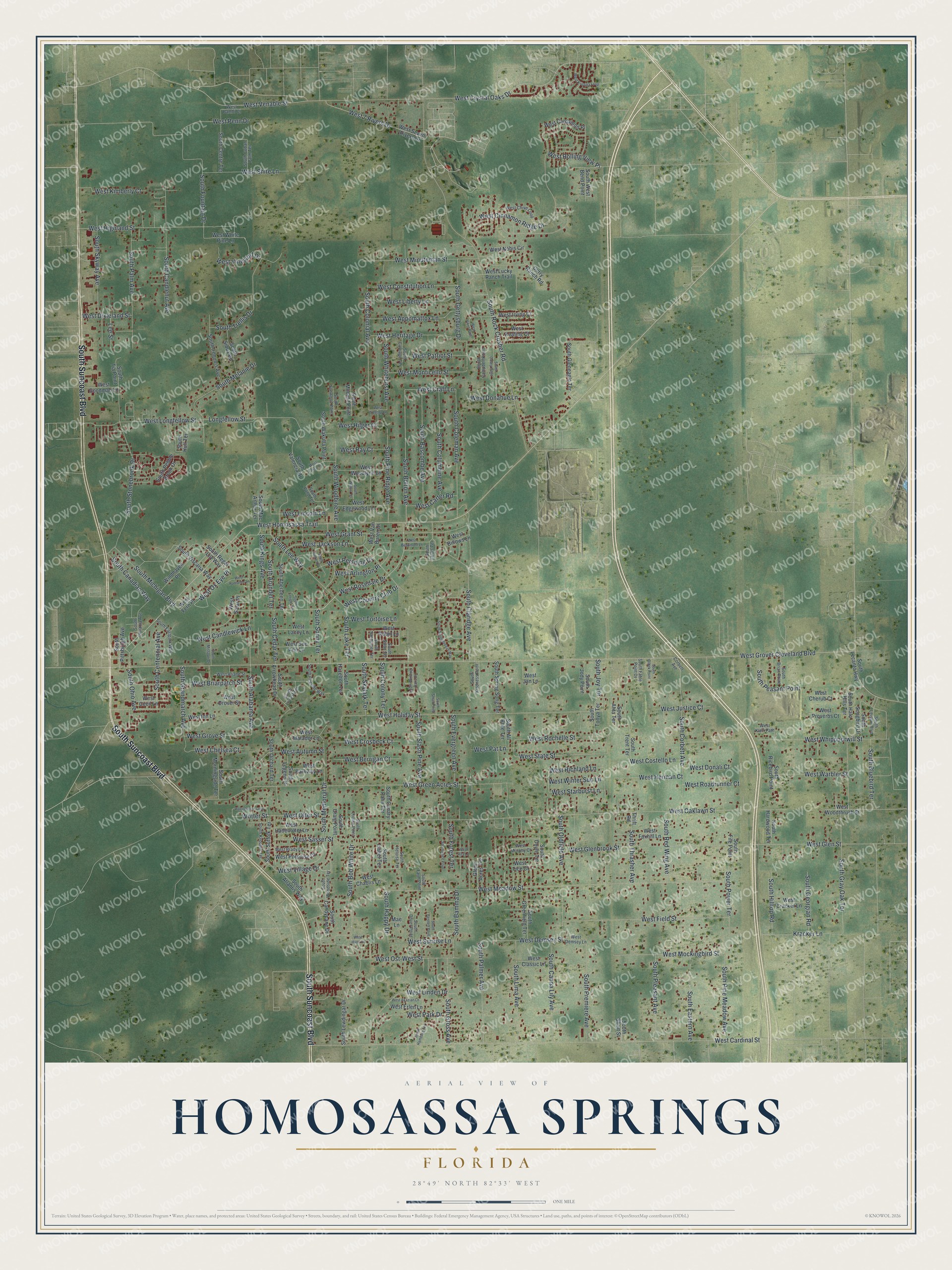
Homosassa Springs, Florida Map Art
Building by building, with labeled streets and shaded relief.
12" x 18" Archival Matte Print
A Map of Home. A Work of Art.
Explore Homosassa Springs, Florida from a whole new perspective. Created using aerial imagery and detailed geographic data, this map captures Homosassa Springs building by building, with labeled streets, familiar landmarks, and shaded topographical relief that highlights the natural contours of the landscape.
Combining modern data with the timeless character of a vintage atlas, this map is just as interesting up close as it is beautiful on the wall. Whether you grew up in Homosassa Springs, spent memorable years there, or call it home today, this unique map is a great way to celebrate a place that means something to you. Zoom in on the preview to look for your street, and then order a print to put your memories on the wall.
Three ways to hang it

Unframed archival matte, a black wood frame or a white wood frame.
Up close
Geography Worth Displaying
This map was created using accurate cartographic data and authoritative geographic sources, including the U.S. Geological Survey and the Census Bureau. The map brings together terrain, waterways, roads, and building detail. The majority of the streets are labeled, houses are accurately depicted, and the topography is derived from government sources. Combining local data with carefully composed color and shading leads to this beautifully detailed Homosassa Springs artwork for your wall.
Rather than simply showing street outlines, we’ve included as many of the street names as we could reasonably fit on the map while keeping their names legible. Zoom in on the high resolution preview to see exactly what’s on the map. We truly set out to create a statement piece for anyone who loves Homosassa Springs. So whether it’s for you, or a gift for someone you love, we hope this map of Homosassa Springs brings back fond memories.
Read the story behind this map of Homosassa Springs, Florida from 2026.

Find your street
Names on the Homosassa Springs map
Every name below is printed on this map. Look for your street, your school, the park where you played, or the pond down the road.
Streets and roads269
- South Suncoast Boulevard
- West Crystal Oaks Drive
- West Ox Eye Place
- West Grover Cleveland Boulevard
- West Rosedale Drive
- West Richland Lane
- West Venable Street
- South Alabama Avenue
- South Bolton Avenue
- West Country Club Drive
- West Homosassa Trail
- West Grove Street
- West Craft Lane
- West Cardinal Street
- West Oaklawn Street
- South Rock Crusher Road
- West Meadow Street
- West Green Acres Street
- West Holiday Street
- West Cinnamon Ridge Drive
- West Grant Street
- West Whippoorwill Street
- South Stonebrook Drive
- West Glen Street
- South Memorial Drive
- West Field Street
- West Highland Street
- South Claridge Avenue
- West Pershing Drive
- South Kings Avenue
Show all 269 streets
- South Candlenut Avenue
- South Coleman Avenue
- South Corbett Avenue
- South Colonial Avenue
- South Oldfield Avenue
- West Longfellow Street
- South Gray Oak Terrace
- South Fountain Drive
- South Palm Avenue
- South Melanie Drive
- South Gettysburg Drive
- South Bascombe Avenue
- West Minuteman Street
- West 7 Rivers Drive
- South Lee Way
- South Bob White Drive
- West Autumn Street
- West Linden Drive
- West Mockingbird Street
- South Columbine Avenue
- South Pine Ridge Avenue
- South Trellis Drive
- South Canna Lily Avenue
- South Lima Avenue
- South Premiere Avenue
- South Palmer Avenue
- South Skyway Avenue
- West Sasser Street
- West Ost-West Street
- South Skylark Terrace
- West Rochelle Street
- West Park Drive
- West State Street
- West Appomattox Lane
- West Glenbrook Street
- West Liberty Lane
- South Michigan Boulevard
- West Heritage Drive
- West Constitution Lane
- Longfellow Street
- West Village Drive
- South Ohio Avenue
- South Eastern Avenue
- South Pleasant Avenue
- South Pine Meadow Avenue
- West Shire Lane
- South Gross Avenue
- West Vineyard Drive
- West Candlewick Lane
- West Demsey Street
- West Warbler Street
- South Woodbine Avenue
- South Centennial Avenue
- West Monticello Street
- South Whitehurst Avenue
- West Penn Drive
- South Hilltop Road
- West Arlington Place
- Kracker Lane
- South Red Wing Avenue
- South Thrasher Avenue
- West Kimberly Court
- South Bluebird Terrace
- South Evergreen Avenue
- South Slash Pine Avenue
- South Power Terrace
- South Grandmarch Avenue
- South Peasant Point
- West Costello Lane
- South Bamma Drive
- West Jackson Lane
- West Briarpatch Street
- West Berrigan Court
- West Herman Court
- West Crosbeck Court
- West Donahue Lane
- West Patriot Street
- South Arundel Terrace
- South Canadian Way
- South Georgian Road
- West Starburst Lane
- West Roadrunner Court
- West Rolling View Place
- West Winter Sun Lane
- West Otter Street
- West Lincoln Lane
- South Lake Terrace
- West Justice Court
- West Donali Court
- South Cedar Terrace
- West Carter Road
- South Sonny Terrace
- West Dixieland Street
- South Colony Terrace
- South Happy Drive
- West Tortoise Lane
- South Forest Terrace
- West Chelsea Court
- West Sunrise Lane
- West Ray Court
- West Pat Lane
- South Joy Terrace
- West Hilger Court
- Wotter Street
- Lee Street
- South Suffolk Terrace
- South Atlantis Way
- South Regal Lily Way
- South Lewdingar Drive
- West Seven Rivers Drive
- West Nobis Circle
- South Legend Drive
- West Fern Place
- South Sioux Road
- South Iroquois Avenue
- West Van Buren Drive
- Thrift Road
- South Valencia Drive
- South Centre Terrace
- South Gleneagle Terrace
- West Inn Lane
- South Aberdeen Terrace
- West Drover Street
- West Porpoise Drive
- South Viscaria Way
- South Morningside Terrace
- South Lecanto Highway
- South Greenfield Terrace
- South Songbird Drive
- South Spring Song Terrace
- West Edgewood Lane
- West Woodlynn Lane
- West Lucky Ranch Trail
- South Arrowhead Drive
- West Foxhill Lane
- South Wakulla Point
- South Isabel Terrace
- West Hadenotter Lane
- South Orchard Terrace
- South Halo Hills Terrace
- West Woodthrush Street
- West Solar Place
- Windhaven Place
- West Chablis Lane
- West Cardamon Place
- West Lacey Lane
- West Sue Ann Lane
- West White Pine Lane
- West Irving Court
- West Cherub Court
- West Proverbs Court
- South Pittsburgh Avenue
- South Ricebird Point
- South Pebble Brook Drive
- South Candycane Drive
- South Tonya Terrace
- West Keating Court
- West Cracker Lane
- West Parkway Lane
- West Erlen Lane
- South Trent Terrace
- West Goodman Lane
- West Classic Lane
- South Canary Palm Terrace
- South Hazelton Terrace
- South Hardwood Terrace
- South All Brite Terrace
- South Mac Arthur Terrace
- South Jody Point
- West Cecil Lane
- South West Bend Point
- South Tia Point
- West Matador Lane
- South Hull Terrace
- South Moonlit Point
- Glenn Acres Terrace
- West Robin Lane
- South Doyle Terrace
- Curry Ranch Road
- South Craig Point
- West Tice Court
- South Alita Terrace
- West Billows Lane
- South Short Street
- South Fife Point
- West Jan Lane
- Mae Lane
- South Calais Terrace
- West Chive Loop
- South Sunwood Point
- West Brady Lane
- South Fireside Way
- South Knobhill Terrace
- South Eastpark Way
- South Cuban Palm Terrace
- South Carriage Terrace
- West Ariane Street
- South Woodside Terrace
- South Campbell Point
- South Kindness Point
- South Sandpiper Terrace
- South Leisure Boulevard
- West Klett Path
- South Brian Point
- West Bambi Court
- West Murphy Court
- South Dover Point
- South Swan Terrace
- South Heloise Terrace
- South Locust Terrace
- South Indiania Avenue
- South Fable Point Drive
- South Louise Point
- South Farm Point
- West Demsey Lane
- South Pond Terrace
- Corbett Avenue
- South Missouri Drive
- West Treetop Lane
- South Springbreeze Way
- South Hamburg Terrace
- West Beaumont Lane
- Wpenderson Loop
- South Junket Drive
- South Winding Oaks Drive
- West Kristina Loop
- West Vikre Path
- West Pasco Place
- South Willow Terrace
- South Casey Point
- West Akazian Lane
- South Alice Point
- South Bennett Point
- West Radiance Lane
- South Olbek Point
- South Small Point
- South Enright Terrace
- West Rita Lane
- West Hans Court
Names are listed as they appear on the printed map. Zoom into the product photos to find them.
About Homosassa Springs, Florida
Homosassa Springs is a community of 14,283 people in southern Citrus County. In 1924, at the peak of the Florida land boom, a firm called the Florida West Coast Development Company purchased several thousand acres here to build a City Beautiful, which locals called New Homosassa. Its streets were laid out 80 to 100 feet wide and its sidewalks nine feet wide, and the plans called for 700 home sites, three country clubs, a golf course, and plazas, parks and boulevards.
- Bust in 1926The Florida land boom collapsed in 1926, and the developers dropped their grand plans for New Homosassa almost at once. Most of the parks, clubs and boulevards were never built. Only two commercial buildings went up, along with a few houses in the Mediterranean Revival style that had been popular during the boom years.
- The Florida Boom SidewalkA stretch of New Homosassa's original wide sidewalk still survives from the developers' plan. In 2010 a Florida historical marker was placed to explain it, describing the sidewalk as a remnant of the City Beautiful look the developers had in mind for Homosassa Springs.
- Named for a warm springThe community takes its name from the warm spring in Homosassa Springs Wildlife State Park, just west of U.S. Routes 19 and 98, where the water draws manatees to the area.
Keep exploring Florida
Homosassa Springs is one of 1,067 Florida towns we've mapped. Every dot on the map is a print of its own.
The search covers every state, Florida first.
Near Homosassa Springs
Order 2 or more town maps and save 10%. Shown in the size and finish you picked above, so they hang as a set.
- Lecanto 12" x 18" / Archival Matte Print $39.99
- Homosassa 12" x 18" / Archival Matte Print $39.99
- Sugarmill Woods 12" x 18" / Archival Matte Print $39.99


More maps nearby: Crystal River, Black Diamond, Citrus Hills, Beverly Hills and Pine Ridge.
The art of mapping a place
How This Map Was Made
Real places. Remarkable detail. Discover the layers that turn geographic data into a map of home.

The view from above
Aerial imagery reveals the character of the land: woodland, open fields, and the patterns of a place.

The shape of the land
Elevation data brings hills, valleys, and subtle changes in the landscape into view.

The details of home
Roads, waterways, and building footprints come together to make the map feel unmistakably local.

Geography becomes art
Considered color, shading, and typography bring the layers together in a map made for your wall.


Process illustrated with Mendon, Massachusetts. Aerial imagery: USDA NAIP. Terrain: USGS 3D Elevation Program. Map details and finished artwork: KNOWOL.
The Details
About This Print
Choose an archival matte print, or a black or white Ayous wood frame. The archival matte print is unframed.
Select your size and finish above to see the matching product image and price.
Materials & Craftsmanship
A contemporary map with the character of a classic atlas, printed on archival matte paper. Optional frames are made from Ayous wood.
Your printed map does not include the watermark shown in the full-map preview.
Shipping & Delivery
Free shipping within the United States. Every print is made to order in the USA.
Buying a gift? Add a note in your cart and we'll include it. We never put prices in the package.
Prints ship within 2 to 3 business days. Allow 7 to 10 days total from ordering for delivery. Timing may vary during holidays or periods of high order volume.
Read our shipping policy.
Returns and damaged prints
Each print is made to order. Change-of-mind refunds are not available after production.
If your print arrives damaged, misprinted or incorrect, contact support@knowol.com within 30 days of receiving it. Include your order number, photos and a description of the issue.
Read our full refund and replacement policy. For questions about your order, email support@knowol.com.