
Search for another town


Free U.S. delivery 7 to 10 days after you order
Indian Trail, North Carolina Map Art
Building by building, with labeled streets and shaded relief.
12" x 18" Archival Matte Print
A Map of Home. A Work of Art.
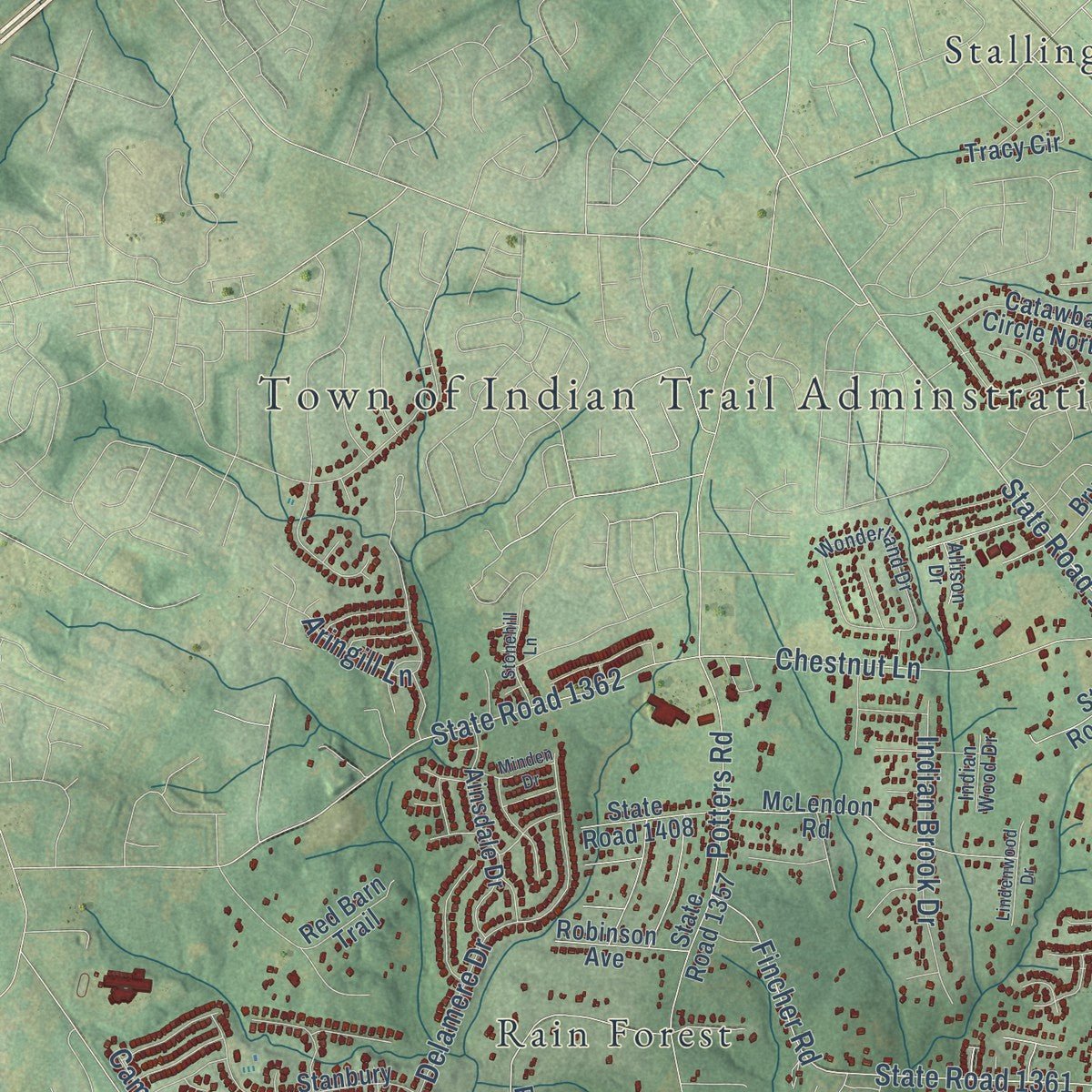
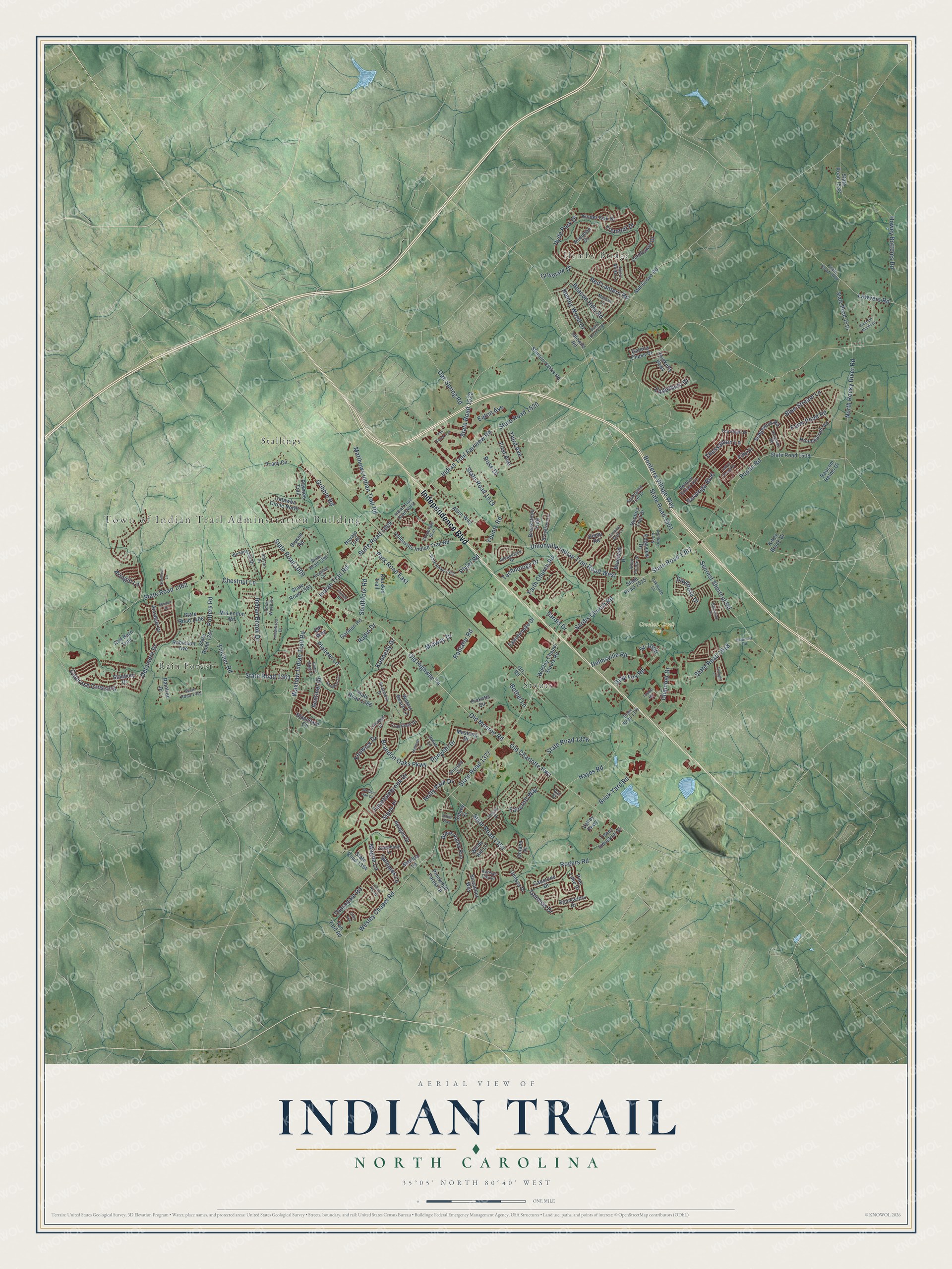
Explore Indian Trail, North Carolina from a whole new perspective. Created using aerial imagery and detailed geographic data, this map captures Indian Trail building by building, with labeled streets, familiar landmarks, and shaded topographical relief that highlights the natural contours of the landscape.
Combining modern data with the timeless character of a vintage atlas, this map is just as interesting up close as it is beautiful on the wall. Whether you grew up in Indian Trail, spent memorable years there, or call it home today, this unique map is a great way to celebrate a place that means something to you. Zoom in on the preview to look for your street, and then order a print to put your memories on the wall.
Three ways to hang it
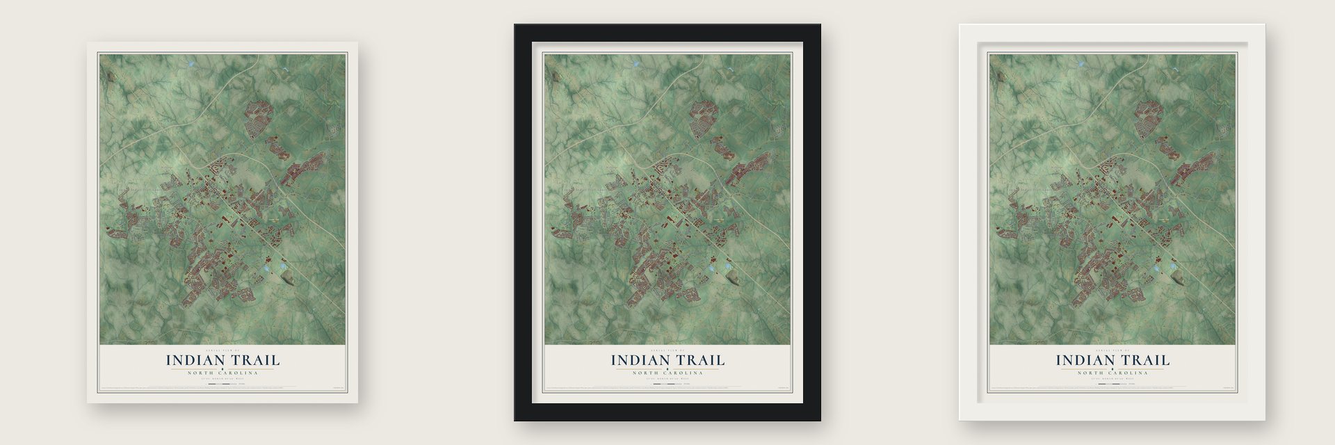
Unframed archival matte, a black wood frame or a white wood frame.
Up close
Geography Worth Displaying
This map was created using accurate cartographic data and authoritative geographic sources, including the U.S. Geological Survey and the Census Bureau. The map brings together terrain, waterways, roads, and building detail. The majority of the streets are labeled, houses are accurately depicted, and the topography is derived from government sources. Combining local data with carefully composed color and shading leads to this beautifully detailed Indian Trail artwork for your wall.
Rather than simply showing street outlines, we’ve included as many of the street names as we could reasonably fit on the map while keeping their names legible. Zoom in on the high resolution preview to see exactly what’s on the map. We truly set out to create a statement piece for anyone who loves Indian Trail. So whether it’s for you, or a gift for someone you love, we hope this map of Indian Trail brings back fond memories.
Read the story behind this map of Indian Trail, North Carolina from 2026.

Find your street
Names on the Indian Trail map
Every name below is printed on this map. Look for your street, your school, the park where you played, or the pond down the road.
Places and landmarks6
- Town of Indian Trail Adminstration Building
- Crooked Creek Park
- Hemby Bridge
- Rain Forest
- Stallings
- Stouts
Streets and roads203
- Independence Boulevard
- State Road 1367
- Old Highway 74
- State Road 1009
- State Road 1377
- Indian Trail Fairview Road
- State Road 1520
- State Road 1008
- Old Monroe Road
- Unionville Indian Trail Road West
- Wesley Chapel Road
- Secrest Shortcut Road
- State Road 1501
- Chestnut Lane
- State Road 1362
- Rogers Road
- State Road 1353
- Waxhaw Indian Trail Road
- Howey Bottoms Road
- Hayes Road
- State Road 1518
- Bonterra Village Way
- Brandon Oaks Parkway
- North Rocky River Road
- State Road 1522
- Indian Trail Road
- Magna Lane
- Poplin Road
- Faith Church Road
- Potters Road
Show all 203 streets
- Old Charlotte Highway
- State Road 1378
- Crismark Drive
- Fincher Road
- Pioneer Lane
- Faircroft Way
- State Road 1361
- Gribble Road
- Brick Yard Road
- Delamere Drive
- Sardis Church Road
- State Road 1519
- Younts Road
- Gray Fox Road
- Matthews Indian Trail Road
- Blue Stream Lane
- Camrose Crossing
- Saratoga Boulevard
- Enderbury Drive
- Plyler Road
- Hyde Park Drive
- Southfork Road
- Indian Brook Drive
- Farm Pond Road
- Daybreak Drive
- Radiator Road
- Sr-1000
- Red Lantern Road
- Lawyers Road
- Chamber Drive
- Sentinel Drive
- Hemby Wood Drive
- Fenwick Drive
- Fountainbrook Drive
- Helmsville Road
- Beacon Hills Road
- Thorndale Road
- Park Road East
- Tremont Drive
- Technology Drive
- Aringill Lane
- Genesis Drive
- Midway Drive
- Ponytail Drive
- Eaton Avenue
- Holly Park Drive
- Semmes Lane
- Thessallian Lane
- Sipes Place
- Oak Spring Road
- First Avenue
- Rose Drive
- Radio Drive
- Sardis Drive
- Kennerly Drive
- Third Avenue
- Bethel Lane
- State Road 1533
- State Road 1514
- Stinson Hartis Road
- State Road 1508
- State Road 1357
- Wesley Chapel Stouts Road
- Unionville Indian Trail Road
- State Road 1386
- State Road 1408
- State Road 1515
- Brook Valley Run
- Red Barn Trail
- McLendon Road
- Raintree Drive
- Edgeview Drive
- Picketts Circle
- Stanbury Drive
- State Road 1354
- Kinder Oak Drive
- Navajo Trail
- Streamlet Way
- Sedgewick Road
- Ainsdale Drive
- Mill Grove Road
- Brookstone Trail
- Pinewood Forest Drive
- Capstone Drive
- Catawba Circle North
- Houndscroft Road
- Allen Way
- Hunters Trail Drive
- Thicketty Parkway
- Tracy Circle
- Fawnbrooke Drive
- Counselors Drive
- Filly Drive
- Braefield Drive
- Idlewild Road
- Tower Industrial Drive
- Cornflower Drive
- Mustang Drive
- State Road 1391
- Pawnee Trail
- Pine Lake Drive
- Garmon Road
- Redskin Trail
- Baucom Helms Drive
- Waters Reach Lane
- Blanchard Circle
- Galena Chase Drive
- Robinson Avenue
- Orr Road
- Apogee Drive
- Bryson Road
- Tan Yard Road
- Windy Hill Lane
- Odessa Place
- Matilda Lane
- Audubon Drive
- Kiker Brock Drive
- Valley Parkway
- Omaha Drive
- Sidney Court
- Elk Way
- Kemp Road
- State Road 1373
- Wonderland Drive
- State Road 1004
- Indian Trail Road North
- Scott Long Road
- Jacquelyne Drive
- Corporate Boulevard
- Belmont Stakes Avenue
- Brooktree Lane
- Shumard Circle
- Keowee Circle
- Oakwood Lane
- State Road 1390
- Potomac Road
- Symphony Lane
- Courtfield Drive
- Southwind Trail Drive
- Top Flight Drive
- Briarmore Drive
- Linstead Drive
- Marcus Lane
- State Road 1379
- Kansas City Drive
- Joyful Noise Lane
- Arbor Pointe Drive
- Devon Drive
- State Road 1451
- Dataw Lane
- Indian Wood Drive
- Allison Drive
- Von Court
- Clover Hill Road
- Haywood Road
- Van Buren Avenue
- Colton Ridge Drive
- State Road 2320
- Garden Oak Drive
- Blackvine Drive
- Emerald Woods Drive
- Ladys Secret Drive
- Sandbox Circle
- Twilight Lane
- Lindenwood Drive
- Stonehill Lane
- Minden Drive
- Orby Avenue
- Lauren Drive
- Cardinal Bluff Lane
- Alyssum Lane
- Tophill Road
- Hilton Way
Names are listed as they appear on the printed map. Zoom into the product photos to find them.
About Indian Trail, North Carolina
Indian Trail is a town of 39,997 people in Union County, about 10 miles southeast of Charlotte. It takes its name from an old trade route, the "Indian Trail," which traders followed from Petersburg, Virginia, south to the Waxhaw Indians and the gold mining country. A state historical marker for the Trading Path says the route split in Mecklenburg County, and one branch ran on to Indian Trail and Waxhaw.
The town dates its founding to March 12, 1861. It began as a farming community, and German, Scots-Irish and Irish settlers moved in because of where it sat. In 1874 the Seaboard Coast Line laid track between Charlotte and Monroe, right through the town, and the railroad brought good times. In 1907 the community was formally incorporated.
- Town limits drawn from the depotWhen Indian Trail was incorporated in 1907, its limits were set as a circle reaching one-half mile out from the spot where Indian Trail Road crossed the Seaboard Railroad. The old depot at that crossing still stands, and an auction business uses it today. CSX Transportation now runs the line.
- From 1,942 to 39,997Indian Trail had 1,942 residents in 1990. Commuters to Charlotte made it one of the area's fastest-growing suburbs, and by 2020 the town had 39,997 people.
- A congressman and a quarterbackIndian Trail counts two well-known names among its own: Mark Harris, a U.S. representative, and Sam Howell, an NFL quarterback for the Dallas Cowboys.
Keep exploring North Carolina
Indian Trail is one of 952 North Carolina towns we've mapped. Every dot on the map is a print of its own.
The search covers every state, North Carolina first.
Near Indian Trail
Order 2 or more town maps and save 10%. Shown in the size and finish you picked above, so they hang as a set.
- Lake Park 12" x 18" / Archival Matte Print $39.99
- Stallings 12" x 18" / Archival Matte Print $39.99
- Hemby Bridge 12" x 18" / Archival Matte Print $39.99


More maps nearby: Matthews, Wesley Chapel, Weddington, Monroe and Mint Hill.
The art of mapping a place
How This Map Was Made
Real places. Remarkable detail. Discover the layers that turn geographic data into a map of home.

The view from above
Aerial imagery reveals the character of the land: woodland, open fields, and the patterns of a place.

The shape of the land
Elevation data brings hills, valleys, and subtle changes in the landscape into view.

The details of home
Roads, waterways, and building footprints come together to make the map feel unmistakably local.

Geography becomes art
Considered color, shading, and typography bring the layers together in a map made for your wall.


Process illustrated with Mendon, Massachusetts. Aerial imagery: USDA NAIP. Terrain: USGS 3D Elevation Program. Map details and finished artwork: KNOWOL.
The Details
About This Print
Choose an archival matte print, or a black or white Ayous wood frame. The archival matte print is unframed.
Select your size and finish above to see the matching product image and price.
Materials & Craftsmanship
A contemporary map with the character of a classic atlas, printed on archival matte paper. Optional frames are made from Ayous wood.
Your printed map does not include the watermark shown in the full-map preview.
Shipping & Delivery
Free shipping within the United States. Every print is made to order in the USA.
Buying a gift? Add a note in your cart and we'll include it. We never put prices in the package.
Prints ship within 2 to 3 business days. Allow 7 to 10 days total from ordering for delivery. Timing may vary during holidays or periods of high order volume.
Read our shipping policy.
Returns and damaged prints
Each print is made to order. Change-of-mind refunds are not available after production.
If your print arrives damaged, misprinted or incorrect, contact support@knowol.com within 30 days of receiving it. Include your order number, photos and a description of the issue.
Read our full refund and replacement policy. For questions about your order, email support@knowol.com.