
Search for another town


Free U.S. delivery 7 to 10 days after you order
Kalaeloa, Hawaii Map Art
Building by building, with labeled streets and shaded relief.
12" x 18" Archival Matte Print
A Map of Home. A Work of Art.
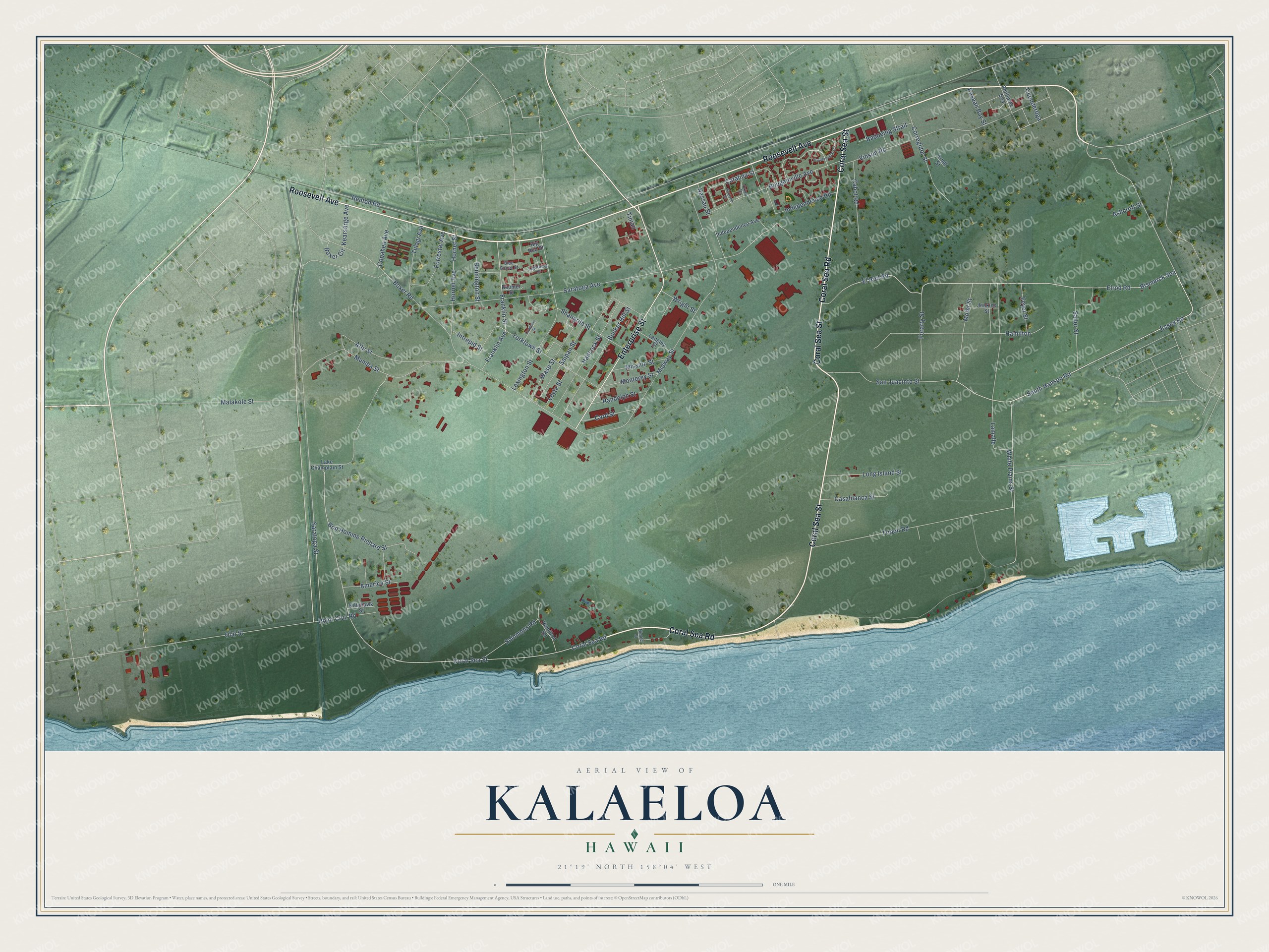
Explore Kalaeloa, Hawaii from a whole new perspective. Created using aerial imagery and detailed geographic data, this map captures Kalaeloa building by building, with labeled streets, familiar landmarks, and shaded topographical relief that highlights the natural contours of the landscape.
Combining modern data with the timeless character of a vintage atlas, this map is just as interesting up close as it is beautiful on the wall. Whether you grew up in Kalaeloa, spent memorable years there, or call it home today, this unique map is a great way to celebrate a place that means something to you. Zoom in on the preview to look for your street, and then order a print to put your memories on the wall.
Three ways to hang it

Unframed archival matte, a black wood frame or a white wood frame.
Up close
Geography Worth Displaying
This map was created using accurate cartographic data and authoritative geographic sources, including the U.S. Geological Survey and the Census Bureau. The map brings together terrain, waterways, roads, and building detail. The majority of the streets are labeled, houses are accurately depicted, and the topography is derived from government sources. Combining local data with carefully composed color and shading leads to this beautifully detailed Kalaeloa artwork for your wall.
Rather than simply showing street outlines, we’ve included as many of the street names as we could reasonably fit on the map while keeping their names legible. Zoom in on the high resolution preview to see exactly what’s on the map. We truly set out to create a statement piece for anyone who loves Kalaeloa. So whether it’s for you, or a gift for someone you love, we hope this map of Kalaeloa brings back fond memories.
Read the story behind this map of Kalaeloa, Hawaii from 2026.

Find your street
Names on the Kalaeloa map
Every name below is printed on this map. Look for your street, your school, the park where you played, or the pond down the road.
Streets and roads86
- Roosevelt Avenue
- Coral Sea Road
- Coral Sea Street
- Enterprise Street
- South Hanson Road
- Elrod Road
- El Rod Road
- Essex Road
- Saratoga Street
- Catalina Street
- Renton Road
- Midway Street
- Saratoga Avenue
- Boxer Road
- Vinson Road
- Tripoli Road
- Olai Street
- Hamilton
- Lexington Street
- Bougainville Avenue
- Mofet Street
- Franklin Avenue
- Franklin Street
- San Juacinto Street
- Lamalle
- Hancock Street
- Bunker Hill Street
- Leyte Street
- Yorktown Street
- Hornet Avenue
Show all 86 streets
- Corregidor Street
- Hornet Street
- Bon Homme Richard Street
- Saipan Street
- Malakole Street
- Attu Street
- Solomons Road
- Forarty Street
- Wasp Street
- Sailor Street
- Nassau Street
- Shangrila Street
- Long Island Street
- Mumba Street
- Forrestal Avenue
- Tulagi Avenue
- Casablanca Street
- Ashcroft Street
- Independence Road
- Point Cruz Road
- Cabot Road
- White Plains Street
- Badoeing Strait
- Monterey Street
- Mission Street
- Randolph Street
- Card Street
- America Street
- Copahee Avenue
- Feyer Street
- Intrepid Street
- Bennington Street
- Kearsarge Avenue
- Wright Street
- Kasaan Bay Street
- Bismarck Sea
- Ticonderoga
- Boxer Circle
- Tinian
- Jenkins Street
- Independence Avenue
- Lake Champlain Street
- Langley Street
- Hamilton Road
- Phillipine Sea
- Kittyhawk Street
- Arndt Street
- Boomer Street
- Big Red Street
- Orion Drive
- Lightning Street
- Blue Goose Street
- Nimitz Street
- Guadalcanal Circle
- Cowpens Street
- Neptune Street
Names are listed as they appear on the printed map. Zoom into the product photos to find them.
About Kalaeloa, Hawaii
Kalaeloa is a community of 2,364 people in Honolulu County, at the southwestern tip of Oahu. Its Hawaiian name, Ka lae loa, means "long point," and English speakers came to call the same point Barbers Point after a shipwreck there. The community stands on the grounds of Naval Air Station Barbers Point, which the Navy closed in 1999 and turned over to the State of Hawaii.
The base got its start in 1925, when the Navy began building Ewa Field around a mooring mast for dirigibles, though no airship ever tied up there. By 1941 Ewa Field had become a new Marine base. Just before 8 AM on December 7, 1941, the Imperial Japanese Navy struck it in the Battle of Ewa Plain, part of the surprise attack on Pearl Harbor. The Navy later folded the Marine field into its larger air station at Barbers Point.
- The wreck of the ArthurCaptain Henry Barber brought the ship Arthur to Hawaii on a trading voyage bound for China. After taking on supplies at Waikiki he set out for Kauai, but beyond the mouth of Pearl Harbor the ship struck a reef in heavy surf and broke apart. Six sailors drowned, while Barber and fifteen others rowed to shore, and the point has carried his name ever since.
- Streets named for Navy shipsWhen the Navy folded the old Marine field into the larger air station at Barbers Point, it named the base's streets for Navy ships. Many honor aircraft carriers, such as Yorktown and Lexington, and those names still mark the streets of Kalaeloa today.
- From air station to airportOnce federal officials put Barbers Point on the list of bases to close, the state legislature set up a commission in 1993 to plan new uses for John Rodgers airfield and 3,700 acres along Oahu's south shore. The Hawaii Community Development Authority took charge on July 1, 2002. The old Navy runways now serve as Kalaeloa Airport, and the former Navy Exchange reopened in January 2011 as an indoor go-cart track.
- A living breakwaterAfter four years of research, scientists from Ohio State University, Florida Atlantic University, the University of California San Diego and its Scripps Institution of Oceanography began a hybrid reef on the rock bottom south of Kalaeloa Harbor. It uses 60 porous concrete structures fitted with coral modules. In large wave tank tests, such breakwaters cut wave energy by more than 80%.
Keep exploring Hawaii
Kalaeloa is one of 169 Hawaii towns we've mapped. Every dot on the map is a print of its own.
The search covers every state, Hawaii first.
Near Kalaeloa
Order 2 or more town maps and save 10%. Shown in the size and finish you picked above, so they hang as a set.
- Kapolei 12" x 18" / Archival Matte Print $39.99
- Ocean Pointe 12" x 18" / Archival Matte Print $39.99
- Ewa Villages 12" x 18" / Archival Matte Print $39.99


More maps nearby: Ewa Gentry, Makakilo, East Kapolei, Ewa Beach and Ko Olina.
The art of mapping a place
How This Map Was Made
Real places. Remarkable detail. Discover the layers that turn geographic data into a map of home.

The view from above
Aerial imagery reveals the character of the land: woodland, open fields, and the patterns of a place.

The shape of the land
Elevation data brings hills, valleys, and subtle changes in the landscape into view.

The details of home
Roads, waterways, and building footprints come together to make the map feel unmistakably local.

Geography becomes art
Considered color, shading, and typography bring the layers together in a map made for your wall.


Process illustrated with Mendon, Massachusetts. Aerial imagery: USDA NAIP. Terrain: USGS 3D Elevation Program. Map details and finished artwork: KNOWOL.
The Details
About This Print
Choose an archival matte print, or a black or white Ayous wood frame. The archival matte print is unframed.
Select your size and finish above to see the matching product image and price.
Materials & Craftsmanship
A contemporary map with the character of a classic atlas, printed on archival matte paper. Optional frames are made from Ayous wood.
Your printed map does not include the watermark shown in the full-map preview.
Shipping & Delivery
Free shipping within the United States. Every print is made to order in the USA.
Buying a gift? Add a note in your cart and we'll include it. We never put prices in the package.
Prints ship within 2 to 3 business days. Allow 7 to 10 days total from ordering for delivery. Timing may vary during holidays or periods of high order volume.
Read our shipping policy.
Returns and damaged prints
Each print is made to order. Change-of-mind refunds are not available after production.
If your print arrives damaged, misprinted or incorrect, contact support@knowol.com within 30 days of receiving it. Include your order number, photos and a description of the issue.
Read our full refund and replacement policy. For questions about your order, email support@knowol.com.