
Search for another town


Free U.S. delivery 7 to 10 days after you order
Lakeville, Massachusetts Map Art
Building by building, with labeled streets and shaded relief.
12" x 18" Archival Matte Print
A Map of Home. A Work of Art.
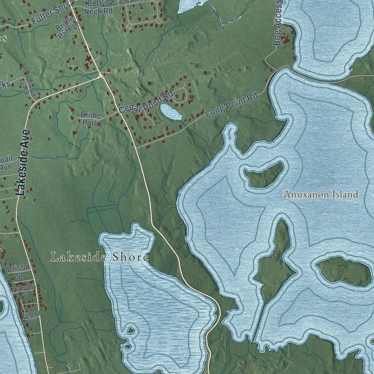
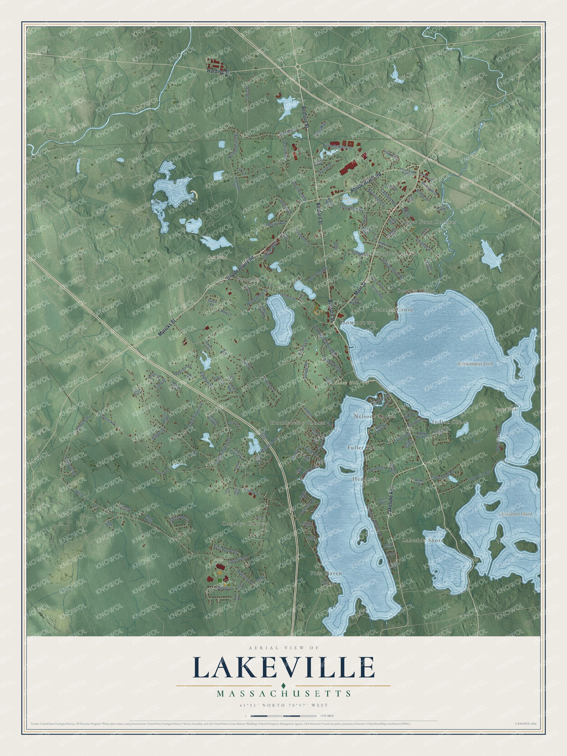
Explore Lakeville, Massachusetts from a whole new perspective. Created using aerial imagery and detailed geographic data, this map captures Lakeville building by building, with labeled streets, familiar landmarks, and shaded topographical relief that highlights the natural contours of the landscape.
Combining modern data with the timeless character of a vintage atlas, this map is just as interesting up close as it is beautiful on the wall. Whether you grew up in Lakeville, spent memorable years there, or call it home today, this unique map is a great way to celebrate a place that means something to you. Zoom in on the preview to look for your street, and then order a print to put your memories on the wall.
Three ways to hang it
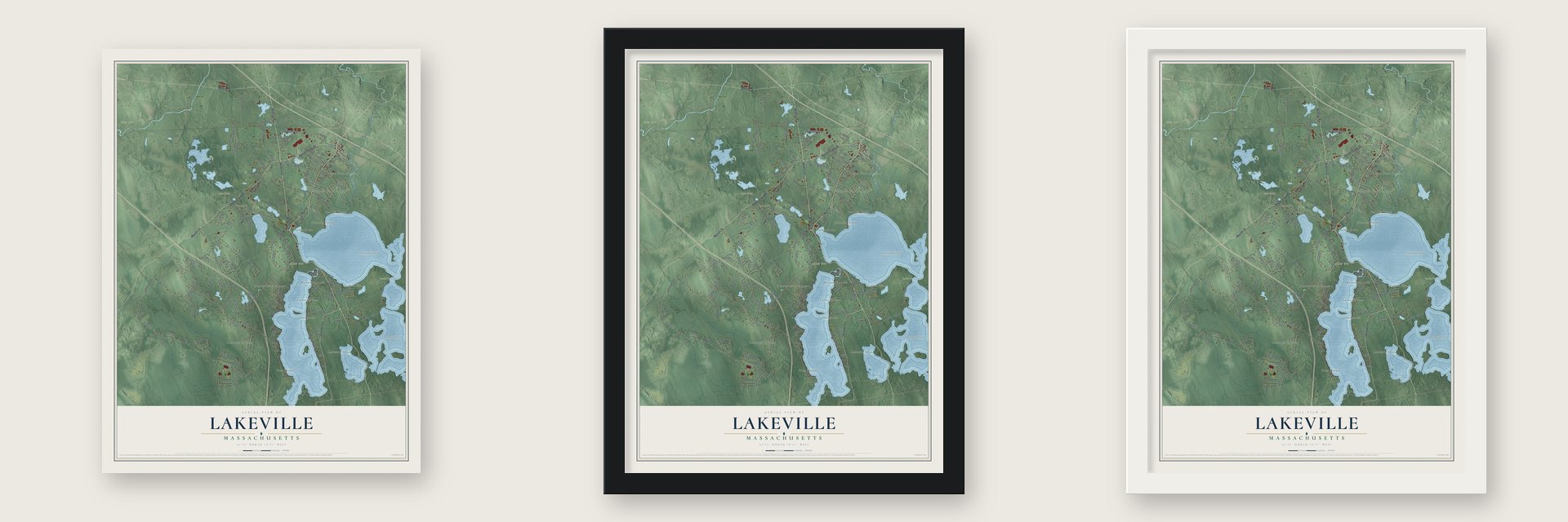
Unframed archival matte, a black wood frame or a white wood frame.
Up close
Geography Worth Displaying
This map was created using accurate cartographic data and authoritative geographic sources, including the U.S. Geological Survey (USGS) and FEMA. The map brings together terrain, waterways, roads, and building detail. The majority of the streets are labeled, houses are accurately depicted, and the topography is derived from government sources. Combining local data with carefully composed color and shading leads to this beautifully detailed Lakeville artwork for your wall.
Rather than simply showing street outlines, we’ve included as many of the street names as we could reasonably fit on the map while keeping their names legible. Zoom in on the high resolution preview to see exactly what’s on the map. We truly set out to create a statement piece for anyone who loves Lakeville. So whether it’s for you, or a gift for someone you love, we hope this map of Lakeville brings back fond memories.
Explore the full map of Lakeville, Massachusetts and read about the local places it shows.

Find your street
Names on the Lakeville map
Every name below is printed on this map. Look for your street, your school, the park where you played, or the pond down the road.
Places and landmarks22
- Downtown
- Alden Hill
- Anuxanon Island
- Betty Hill
- Bettys Neck
- Assawompset Pond
- Cain Pond
- Clear Pond Park
- Cr #1
- Lakeside Shore
- Pine Haven
- Hemlocks
Show all 22 places
- Canedys Corner
- Huckleberry Shores
- Staples Shore
- Nelsons Grove
- Nelsons Shores
- Upper Four Corners
- Staples Corner
- Fuller Shores
- Indian Shore
- Precinct
Streets and roads147
- Bedford Street
- Main Street
- Myricks Street
- Lakeside Avenue
- Rhode Island Road
- Harding Street
- Howland Road
- Crooked Lane
- Staples Shore Road
- Vaughan Street
- Grove Avenue
- County Street
- Kingman Street
- Highland Road
- Pierce Avenue
- Pickens Street
- Kenneth Welch Drive
- Precinct Street
- Taunton Street
- Montgomery Street
- Southworth Street
- Freetown Street
- Baker Lane
- Long Point Road
- Malbone Street
- South Kingman Street
- Loon Pond Road
- Clear Pond Road
- Cross Street
- Mill Street
Show all 147 streets
- Hill Street
- Sherwood Lane
- Old Powder House Road
- South Pickens Street
- North Precinct Street
- Clark Road
- Bridge Street
- Fuller Shrs
- Heritage Hill Drive
- Johnson Drive
- Lebaron Boulevard
- Harrison Avenue
- Bog Access Road
- Captains Way
- Leonard Street
- Bells Brook Road
- Stetson Street
- Cedar Pond Road
- Lang Street
- Churchill Road
- Riverside Drive
- Village Road
- School Street
- Surrey Drive
- Shore Avenue
- Pine Bluff
- Parkhurst Drive
- New Lane
- Emerson Road
- Tylers Way
- Pond Lane
- Bettys Neck Road
- Old Main Street
- Haskell Circle
- Nelson Shore Road
- Settlers Drive
- Galfre Road
- West Vaughan Street
- Race Course Road
- Quail Run
- Panettieri Drive
- Robbins Lane
- Alberta Lane
- Central Avenue
- Jennifer Lane
- Reed Farm Road
- Elders Pond Road
- Elliot Way
- Twin Oaks Road
- Hackett Avenue
- Pilgrim Road
- Coombs Street
- Bristol Street
- Jamies Way
- Bridle Path
- Meadow Lane
- Highstone Street
- Green Lot Circle
- Mya Lane
- Keith Avenue
- Deneise Street
- Wind Rush
- Bridle Path Lane
- Azel Road
- Wynns Way
- Oshing Way
- Josh Road
- Lori Lane
- Oak Street
- Nachaomet Road
- Forest Park Drive
- Stonehedge Drive
- Priscilla Drive
- Moulton Street
- Holloway Brook Road
- Pheasant Run Road
- Mullein Hill Drive
- Commercial Drive
- Anderson Way
- Wisteria Street
- Harcourt Avenue
- Rhode Island Road Extension
- Fairway Drive
- Wood's Edge Road
- Joshua Lane
- Flintlock Lane
- Alden Road
- Old Bridge Street
- Island Road
- Julias Way
- Island Vw
- Ivy Lane
- Hemlock Farm Road
- Rush Pond Road
- Carriage House Drive
- Barstow Street
- Halcyon Farm Road
- Margeaux Drive
- Great Cedar Crossing
- Plymouth Street
- Pine Ridge Drive
- Deerfield Lane
- Hickory Lane
- Langlois Pines
- Unicorn Lane
- Rachel's Way
- Gillian Drive
- Wordell Lane
- Smith Circle
- Shaylee Lane
- Cedar Berry Lane
- Yellow Brick Road
- Carrie Street
- Trinity Lane
- First Avenue
- Andrea Avenue
- Fern Avenue
Names are listed as they appear on the printed map. Zoom into the product photos to find them.
About Lakeville, Massachusetts
Lakeville is a town of 11,523 people in Plymouth County, set among a chain of great ponds: Assawompset, Great Quittacas, Little Quittacas, Pocksha and Long. This was Wampanoag land called Soewampset, and a Wampanoag community lived beside Assawompset Pond until at least the early 1800s. A man named Peirce made the first recorded settler's home in 1705, and in 1717 Thomas Nelson built a house on Assawompset Neck as the area filled in as Middleborough's western parish.
In 1853 the parish broke away from Middleborough, and on January 29 its voters met in a schoolhouse to pick a name. Oliver Pierce pushed for Bristol, and Austin J. Roberts argued for Laketon, after the ponds. Most voters wanted Nelson, in honor of Job Pierce Nelson, the man who had done more than anyone to bring about the split, but he turned the honor down. The town settled on Lakeville instead and was incorporated on May 13, 1853.
“Formerly distinguished, as was Egypt, for its remarkable productiveness in grain.”
- A body beneath the iceIn 1675 the body of John Sassamon, an advisor to Governor Josiah Winslow, was pulled from beneath the ice on Assawompset Pond. Three Native men were convicted of his murder on the word of a single witness, though English law called for two.
- The trial that started a warTobias, a senior counselor to King Philip, and a second of the convicted men were hanged for Sassamon's murder. The rope broke on the third, Tobias's son, who was jailed after a confession many believe was forced. The trial is widely seen as the spark of King Philip's War, and Metacomet's forces later sheltered at Assawompset Pond.
- The woman called BettyIn 1673 Tuspaquin, the Black Sachem, and his son handed the point called Nahteawamet to Assawetough, a daughter of John Sassamon. The English called her Betty, and Betty's Neck still carries her name. She left the land to her daughter Mercy in 1696, and her family kept it for generations. Zerviah Gould Mitchell, a descendant still living on the neck, published a book in 1878 about Massasoit's history and his descendants.
- Seventeen stolen doorsZebidee Sproat took over the old Ward house, first a small garrison house of oak planks, in 1778 and laid out a terraced garden. A fierce enemy of King George, he joined in the sacking of Judge Oliver's house at Nemasket, and before it burned he carried off its inside doors. Seventeen of them were hung in his bedrooms and upstairs hall. General Ephraim Ward bought the house in 1806.
- Town Hall of 1856Lakeville built its Greek Revival Town Hall in 1856 at Precinct and Bedford Streets. For nearly a century it held town meetings, the selectmen's offices and at times the library. Town offices moved out in 1952, but the hall is still used for meetings, and it joined the National Register in 1976.
Keep exploring Massachusetts
Lakeville is one of 470 Massachusetts towns we've mapped. Every dot on the map is a print of its own.
The search covers every state, Massachusetts first.
Near Lakeville
Order 2 or more town maps and save 10%. Shown in the size and finish you picked above, so they hang as a set.
- Freetown 12" x 18" / Archival Matte Print $39.99
- Middleborough 12" x 18" / Archival Matte Print $39.99
- Berkley 12" x 18" / Archival Matte Print $39.99


More maps nearby: Rochester, Raynham, Acushnet, Taunton and Bridgewater.
The art of mapping a place
How This Map Was Made
Real places. Remarkable detail. Discover the layers that turn geographic data into a map of home.

The view from above
Aerial imagery reveals the character of the land: woodland, open fields, and the patterns of a place.

The shape of the land
Elevation data brings hills, valleys, and subtle changes in the landscape into view.

The details of home
Roads, waterways, and building footprints come together to make the map feel unmistakably local.

Geography becomes art
Considered color, shading, and typography bring the layers together in a map made for your wall.


Process illustrated with Mendon, Massachusetts. Aerial imagery: USDA NAIP. Terrain: USGS 3D Elevation Program. Map details and finished artwork: KNOWOL.
The Details
About This Print
Choose an archival matte print, or a black or white Ayous wood frame. The archival matte print is unframed.
Select your size and finish above to see the matching product image and price.
Materials & Craftsmanship
A contemporary map with the character of a classic atlas, printed on archival matte paper. Optional frames are made from Ayous wood.
Your printed map does not include the watermark shown in the full-map preview.
Shipping & Delivery
Free shipping within the United States. Every print is made to order in the USA.
Buying a gift? Add a note in your cart and we'll include it. We never put prices in the package.
Prints ship within 2 to 3 business days. Allow 7 to 10 days total from ordering for delivery. Timing may vary during holidays or periods of high order volume.
Read our shipping policy.
Returns and damaged prints
Each print is made to order. Change-of-mind refunds are not available after production.
If your print arrives damaged, misprinted or incorrect, contact support@knowol.com within 30 days of receiving it. Include your order number, photos and a description of the issue.
Read our full refund and replacement policy. For questions about your order, email support@knowol.com.