


Search for another town


Free U.S. delivery 7 to 10 days after you order
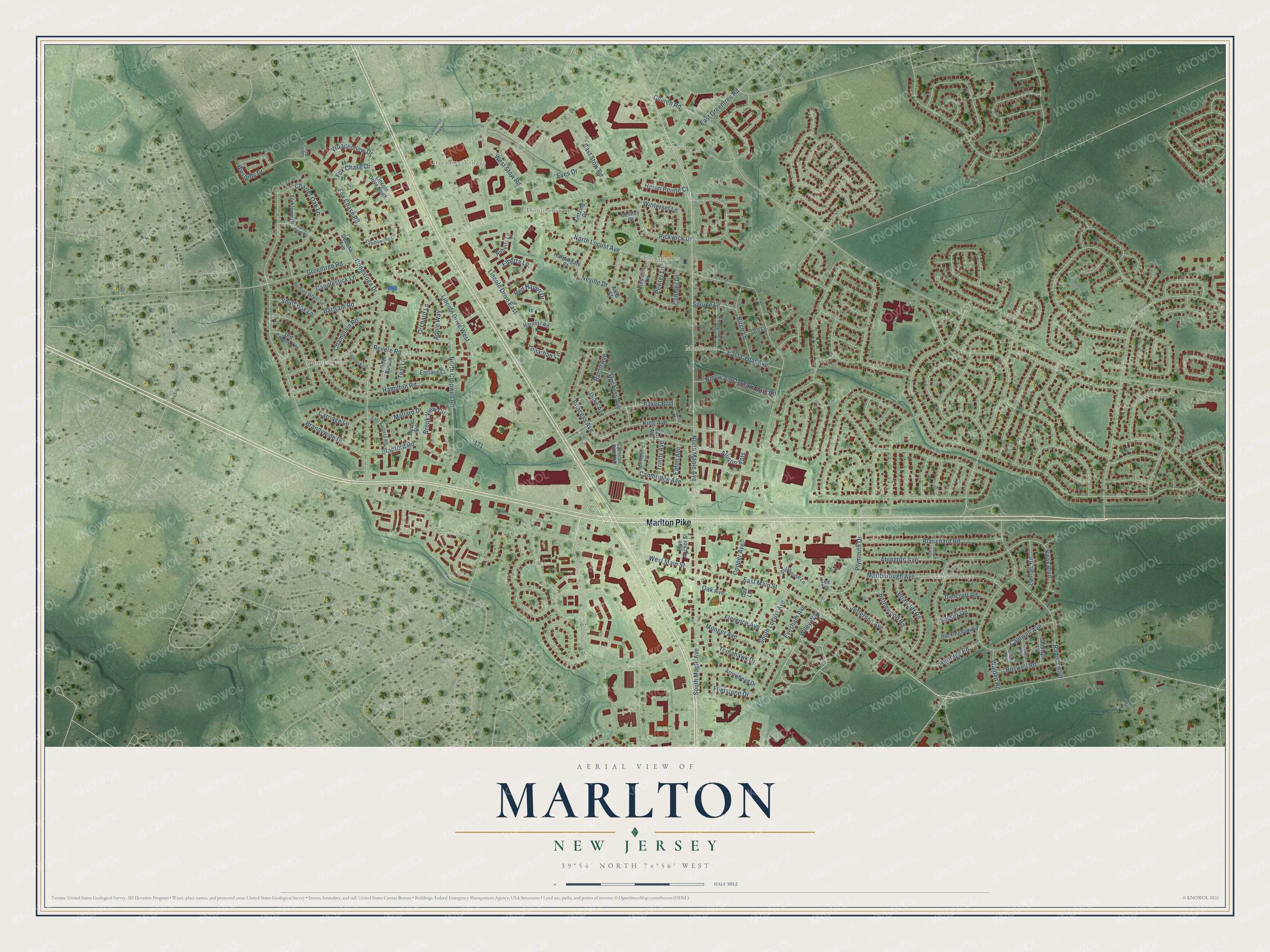
Marlton, New Jersey Map Art
Building by building, with labeled streets and shaded relief.
12" x 18" Archival Matte Print
A Map of Home. A Work of Art.
Explore Marlton, New Jersey from a whole new perspective. Created using aerial imagery and detailed geographic data, this map captures Marlton building by building, with labeled streets, familiar landmarks, and shaded topographical relief that highlights the natural contours of the landscape.
Combining modern data with the timeless character of a vintage atlas, this map is just as interesting up close as it is beautiful on the wall. Whether you grew up in Marlton, spent memorable years there, or call it home today, this unique map is a great way to celebrate a place that means something to you. Zoom in on the preview to look for your street, and then order a print to put your memories on the wall.
Three ways to hang it

Unframed archival matte, a black wood frame or a white wood frame.
Up close
Geography Worth Displaying
This map was created using accurate cartographic data and authoritative geographic sources, including the U.S. Geological Survey (USGS) and FEMA. The map brings together terrain, waterways, roads, and building detail. The majority of the streets are labeled, houses are accurately depicted, and the topography is derived from government sources. Combining local data with carefully composed color and shading leads to this beautifully detailed Marlton artwork for your wall.
Rather than simply showing street outlines, we’ve included as many of the street names as we could reasonably fit on the map while keeping their names legible. Zoom in on the high resolution preview to see exactly what’s on the map. We truly set out to create a statement piece for anyone who loves Marlton. So whether it’s for you, or a gift for someone you love, we hope this map of Marlton brings back fond memories.
Explore the full map of Marlton, New Jersey and read about the local places it shows.

Find your street
Names on the Marlton map
Every name below is printed on this map. Look for your street, your school, the park where you played, or the pond down the road.
Places and landmarks7
- Marlboro
- Woodstream
- Evesboro
- Heritage Village
- Greentree Village
- The Maples
- Donlontown
Streets and roads120
- Marlton Pike
- North Maple Avenue
- Allison Apts
- Plymouth Drive
- West Main Street
- Fox Chase Drive
- Wiley Way
- East Main Street
- Red Haven Drive
- Lincoln Drive West
- North Locust Avenue
- East Greentree Road
- Brandywine Drive
- Knox Boulevard
- Lincoln Drive East
- Conestoga Drive
- Hamilton Road
- Radnor Boulevard
- Caldwell Avenue
- East Stow Road
- North Cropwell Road
- Westerly Drive
- Baker Boulevard
- Marlborough Avenue
- Pickwick Drive
- Blanchard Road
- Charter Oak Lane
- Brook View Circle
- South Maple Avenue
- Apple Way
Show all 120 streets
- Eves Drive
- King Avenue
- Oak Avenue
- Nieuw Amsterdam Apts Road
- Champlain Road
- Greentree Road
- Neville Drive
- Heritage Road
- Princess Avenue
- Flintstone Drive
- Bettlewood Road
- South Locust Avenue
- Fox Chase Road
- East Cedar Avenue
- Jonathan Lane
- Elberta Lane
- Abington Avenue
- Cambridge Avenue
- Briarcliff Road
- Bartram Road
- Revere Road
- Birch Lane
- Orchard Lane
- Boswell Road
- Winterset Lane
- West Stow Road
- Jefferson Avenue
- Munger Avenue
- Duchess Avenue
- Woodhollow Drive
- Florence Avenue
- Tomahawk Drive
- Church Road
- Candlestick Lane
- Cooper Avenue
- Bancroft Road
- Carriage Lane
- Evesham Avenue
- Bradford Road
- Lanfair Road
- Snuff Box Lane
- Heron Pointe Court
- Sussex Road
- Mallard Drive
- Spruce Lane
- Baron Avenue
- Duke Avenue
- Walden Road
- Trinity Avenue
- Eaton Avenue
- Pewter Lane
- Cobbler Lane
- Teal Lane
- Lincoln Drive North
- Old Colony Lane
- Roberts Lane
- Camelot Apts Road
- Arrowhead Drive
- Tinsmith Lane
- Evergreen Lane
- Buckingham Road
- Tinder Box Lane
- Deltona Avenue
- Yorktown Drive
- Gladwyn Road
- Enclave Court
- Stillhouse Lane
- Mystic Road
- Blue Anchor Street
- Harrowgate Court
- Kintzing Drive
- Harvest Road
- Ore Lane
- Bentley Court
- Alvis Court
- Oak Lane
- Earl Avenue
- Lee Terrace
- Candlewood Circle
- Spinning Wheel Lane
- East Burgess Road
- Commerce Parkway
- Devon Road
- Flintlock Lane
- Oxford Road
- Valley Forge Road
- Manchester Avenue
- Counts Court
- Hobart Avenue
- Eagle Row
Names are listed as they appear on the printed map. Zoom into the product photos to find them.
About Marlton, New Jersey
Marlton is a census-designated place of 10,594 people inside Evesham Township, in Burlington County, and many people use its name for the whole township. Welsh and English farmers began settling here in 1676, though the name Marlton did not show up until the early 19th century.
The name comes from marl, a clay found all through the local soil. Once farmers and merchants learned what the marl could do for them, the village had its first building boom in the 1830s and 1840s. The marl pits stayed open until they were shut down in 1930. The clay was sold nearby or sent by rail to Burlington City, Philadelphia and Atlantic City, then reshipped for fertilizer in place of green manure, for treating water and for fill.
- Rail service from 1881 to 1927The Philadelphia Marlton and Medford Railroad began stopping at several points in Marlton in July 1881. Its trains kept serving the village for more than forty years, until September 24, 1927.
- A Nike missile base in 1955During the Cold War, PH-32, a Project Nike missile base, was finished in 1955. It took up a 38-acre site close to Marlton Middle School.
- The end of the Marlton CircleRoute 70 and Route 73 once met at the Marlton Circle, a traffic circle. In 2010 the circle was torn out and replaced with an interchange that lifts Route 73 over Route 70, and the new traffic pattern was done by late 2011.
Keep exploring New Jersey
Marlton is one of 990 New Jersey towns we've mapped. Every dot on the map is a print of its own.
The search covers every state, New Jersey first.
Near Marlton
Order 2 or more town maps and save 10%. Shown in the size and finish you picked above, so they hang as a set.
- Greentree 12" x 18" / Archival Matte Print $39.99
- Ramblewood 12" x 18" / Archival Matte Print $39.99
- Springdale 12" x 18" / Archival Matte Print $39.99


More maps nearby: Kresson, Kingston Estates, Evesham, Cherry Hill and Mount Laurel.
The art of mapping a place
How This Map Was Made
Real places. Remarkable detail. Discover the layers that turn geographic data into a map of home.

The view from above
Aerial imagery reveals the character of the land: woodland, open fields, and the patterns of a place.

The shape of the land
Elevation data brings hills, valleys, and subtle changes in the landscape into view.

The details of home
Roads, waterways, and building footprints come together to make the map feel unmistakably local.

Geography becomes art
Considered color, shading, and typography bring the layers together in a map made for your wall.


Process illustrated with Mendon, Massachusetts. Aerial imagery: USDA NAIP. Terrain: USGS 3D Elevation Program. Map details and finished artwork: KNOWOL.
The Details
About This Print
Choose an archival matte print, or a black or white Ayous wood frame. The archival matte print is unframed.
Select your size and finish above to see the matching product image and price.
Materials & Craftsmanship
A contemporary map with the character of a classic atlas, printed on archival matte paper. Optional frames are made from Ayous wood.
Your printed map does not include the watermark shown in the full-map preview.
Shipping & Delivery
Free shipping within the United States. Every print is made to order in the USA.
Buying a gift? Add a note in your cart and we'll include it. We never put prices in the package.
Prints ship within 2 to 3 business days. Allow 7 to 10 days total from ordering for delivery. Timing may vary during holidays or periods of high order volume.
Read our shipping policy.
Returns and damaged prints
Each print is made to order. Change-of-mind refunds are not available after production.
If your print arrives damaged, misprinted or incorrect, contact support@knowol.com within 30 days of receiving it. Include your order number, photos and a description of the issue.
Read our full refund and replacement policy. For questions about your order, email support@knowol.com.