


Search for another town


Free U.S. delivery 7 to 10 days after you order
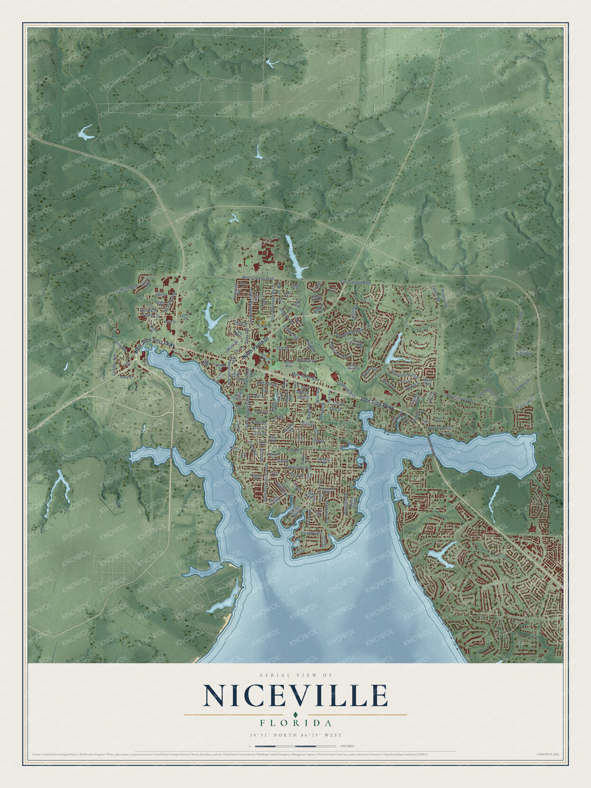
Niceville, Florida Map Art
Building by building, with labeled streets and shaded relief.
12" x 18" Archival Matte Print
A Map of Home. A Work of Art.
Explore Niceville, Florida from a whole new perspective. Created using aerial imagery and detailed geographic data, this map captures Niceville building by building, with labeled streets, familiar landmarks, and shaded topographical relief that highlights the natural contours of the landscape.
Combining modern data with the timeless character of a vintage atlas, this map is just as interesting up close as it is beautiful on the wall. Whether you grew up in Niceville, spent memorable years there, or call it home today, this unique map is a great way to celebrate a place that means something to you. Zoom in on the preview to look for your street, and then order a print to put your memories on the wall.
Three ways to hang it

Unframed archival matte, a black wood frame or a white wood frame.
Up close
Geography Worth Displaying
This map was created using accurate cartographic data and authoritative geographic sources, including the U.S. Geological Survey (USGS) and FEMA. The map brings together terrain, waterways, roads, and building detail. The majority of the streets are labeled, houses are accurately depicted, and the topography is derived from government sources. Combining local data with carefully composed color and shading leads to this beautifully detailed Niceville artwork for your wall.
Rather than simply showing street outlines, we’ve included as many of the street names as we could reasonably fit on the map while keeping their names legible. Zoom in on the high resolution preview to see exactly what’s on the map. We truly set out to create a statement piece for anyone who loves Niceville. So whether it’s for you, or a gift for someone you love, we hope this map of Niceville brings back fond memories.
Explore the full map of Niceville, Florida and read about the local places it shows.

Find your street
Names on the Niceville map
Every name below is printed on this map. Look for your street, your school, the park where you played, or the pond down the road.
Places and landmarks1
- Dana Point
Streets and roads152
- John Sims Parkway
- West John Sims Parkway
- North Partin Drive
- Crossing Boulevard
- Cedar Avenue South
- 21st Street
- 23rd Street
- College Boulevard
- East College Boulevard
- West College Boulevard
- Bayshore Drive
- Palm Boulevard North
- Deer Moss Loop
- Palm Boulevard South
- Rocky Bayou Drive
- 27th Street
- Forest Road
- Cedar Avenue North
- Valparaiso Boulevard
- Juniper Avenue
- 20th Street
- 22nd Street
- Caraway Drive
- Niceville Avenue
- Sweetwater Run
- Marc Smith Boulevard
- McEwen Drive
- Kildare Circle
- Finck Road
- Roscommon Boulevard
Show all 152 streets
- Fir Avenue
- Kelly Road
- Third Street
- Edgewater Drive
- Dana Pointe
- Bailey Drive
- 37th Street
- Nathey Street
- Roberts Drive
- Jefferson Street
- Reynolds Avenue
- Coral Drive
- 29th Street
- Mulry Drive
- Hart Street
- 31st Street
- Davis Drive
- Deer Avenue
- Florida Street
- Cadillac Avenue
- Rhonda Drive
- Canal Drive
- 26th Street
- 17th Street
- Reeves Street
- Dyer Street
- Iowa Street
- Wise Avenue
- Scott Street
- 28th Street
- Paradise Road
- Cedar Avenue
- Coldwater Creek Circle
- Beverly Drive
- 45th Street
- Red Maple Way
- Linden Avenue
- Hickory Avenue
- Galway Drive
- Foxglove Run
- Evergreen Avenue
- Saint Andrews Drive
- Grove Park Drive
- Pin Oak Circle
- Woods Drive
- Elderflower Drive
- Persimmon Way
- Falcon Trail
- Royal Palm Drive
- Pine Avenue
- Park Avenue
- Evans Street
- Weeden Island Drive
- Helms Street
- Gracie Lane
- Reindeer Road
- Hillside Drive
- Edge Avenue
- Town Center Boulevard
- Elm Street
- Ivy Avenue
- Abner Way
- Allen Avenue
- Fairway Drive
- Bahia Vista Drive
- Biscayne Lane
- Christy Avenue
- Sabal Palm Drive
- Biltmore Way
- Bally Way
- Phyllis Avenue
- Pine Lake Drive
- Boxer Avenue
- Karen Court
- 18th Street
- Harding Road
- Lewis Street
- Riley Road
- Hill Lane
- Tee Street
- Winding Waters Way
- Rocky Shores Drive
- Yacht Club Drive
- Sterling River Way
- Nutmeg Avenue
- Maple Avenue
- Duke Drive
- Perdido Circle
- Old Costal Highway
- Fairwood Drive
- Dolphin Point Road
- Adams Street
- Emmett Drive
- Poplar Place
- Campbell Drive
- Azalea Drive
- Rushing River Way
- 30th Street
- Byrne Street
- Woodlow Road
- Julia Avenue
- Hospital Drive
- 46th Street
- Duncan Drive
- Black Bear Circle
- Everglade Drive
- Killarney Road
- Bullock Boulevard
- South Partin Drive
- Cypress Drive
- Hudson Circle
- Bayou Drive
- 47th Street
- Kumquat Avenue
- Parker Drive
- Oak Avenue
- Balsam Drive
- Sweet Basil Lane
- Spence Circle
- Meigs Drive
- Green Oak Lane
- Teresa Court
Names are listed as they appear on the printed map. Zoom into the product photos to find them.
About Niceville, Florida
Niceville is a city of 15,772 people in Okaloosa County, on Boggy Bayou where it meets Choctawhatchee Bay. Its mail service started on July 21, 1868, and back then the settlement went by the name Boggy. On November 5, 1910, the town officially became Niceville, a name picked by the postmaster's daughter.
Niceville belonged to Walton County until 1915, when Okaloosa County was formed and the town became part of the new county. Valparaiso shares its western border, and the two are known as twin cities. During World War II the military graded a railroad line into the region, and its only commercial customer was a lumber pulp yard at Niceville. Community athletic fields stand on that ground today.
- A college from 1963The Florida Legislature created the school in 1963. Its first classes began in August 1964, under the name Okaloosa-Walton Junior College. In January 1966 an Act of Congress handed over its 264-acre campus from the Eglin Air Force Reservation. It became Northwest Florida State College in 2008. Its teams are the Raiders, named for the Doolittle Raiders of World War II, who trained at nearby Eglin.
- Diploma and degree togetherCollegiate High School opened on the college campus in 2000 as a charter school, letting students finish high school and earn a college degree at the same time. It won the National Blue Ribbon School award twice, in 2006 and again in 2013.
- A 1,650-seat stageThe Mattie Kelly Arts Center, on the Northwest Florida State College campus, holds a main stage theater with 1,650 seats.
- The Boggy Bayou Mullet FestivalChoctawhatchee Bay supports both commercial and sport fishing, with mullet, red drum, spotted seatrout, sheepshead and flounder in its waters. Niceville honored the catch with the Boggy Bayou Mullet Festival every year, an event later renamed the Boggy Fest.
Keep exploring Florida
Niceville is one of 1,067 Florida towns we've mapped. Every dot on the map is a print of its own.
The search covers every state, Florida first.
Near Niceville
Order 2 or more town maps and save 10%. Shown in the size and finish you picked above, so they hang as a set.
- Valparaiso 12" x 18" / Archival Matte Print $39.99
- Eglin AFB 12" x 18" / Archival Matte Print $39.99
- Lake Lorraine 12" x 18" / Archival Matte Print $39.99


More maps nearby: Longwood, Destin, Shalimar, Ocean City and Cinco Bayou.
The art of mapping a place
How This Map Was Made
Real places. Remarkable detail. Discover the layers that turn geographic data into a map of home.

The view from above
Aerial imagery reveals the character of the land: woodland, open fields, and the patterns of a place.

The shape of the land
Elevation data brings hills, valleys, and subtle changes in the landscape into view.

The details of home
Roads, waterways, and building footprints come together to make the map feel unmistakably local.

Geography becomes art
Considered color, shading, and typography bring the layers together in a map made for your wall.


Process illustrated with Mendon, Massachusetts. Aerial imagery: USDA NAIP. Terrain: USGS 3D Elevation Program. Map details and finished artwork: KNOWOL.
The Details
About This Print
Choose an archival matte print, or a black or white Ayous wood frame. The archival matte print is unframed.
Select your size and finish above to see the matching product image and price.
Materials & Craftsmanship
A contemporary map with the character of a classic atlas, printed on archival matte paper. Optional frames are made from Ayous wood.
Your printed map does not include the watermark shown in the full-map preview.
Shipping & Delivery
Free shipping within the United States. Every print is made to order in the USA.
Buying a gift? Add a note in your cart and we'll include it. We never put prices in the package.
Prints ship within 2 to 3 business days. Allow 7 to 10 days total from ordering for delivery. Timing may vary during holidays or periods of high order volume.
Read our shipping policy.
Returns and damaged prints
Each print is made to order. Change-of-mind refunds are not available after production.
If your print arrives damaged, misprinted or incorrect, contact support@knowol.com within 30 days of receiving it. Include your order number, photos and a description of the issue.
Read our full refund and replacement policy. For questions about your order, email support@knowol.com.