


Search for another town


Free U.S. delivery 7 to 10 days after you order
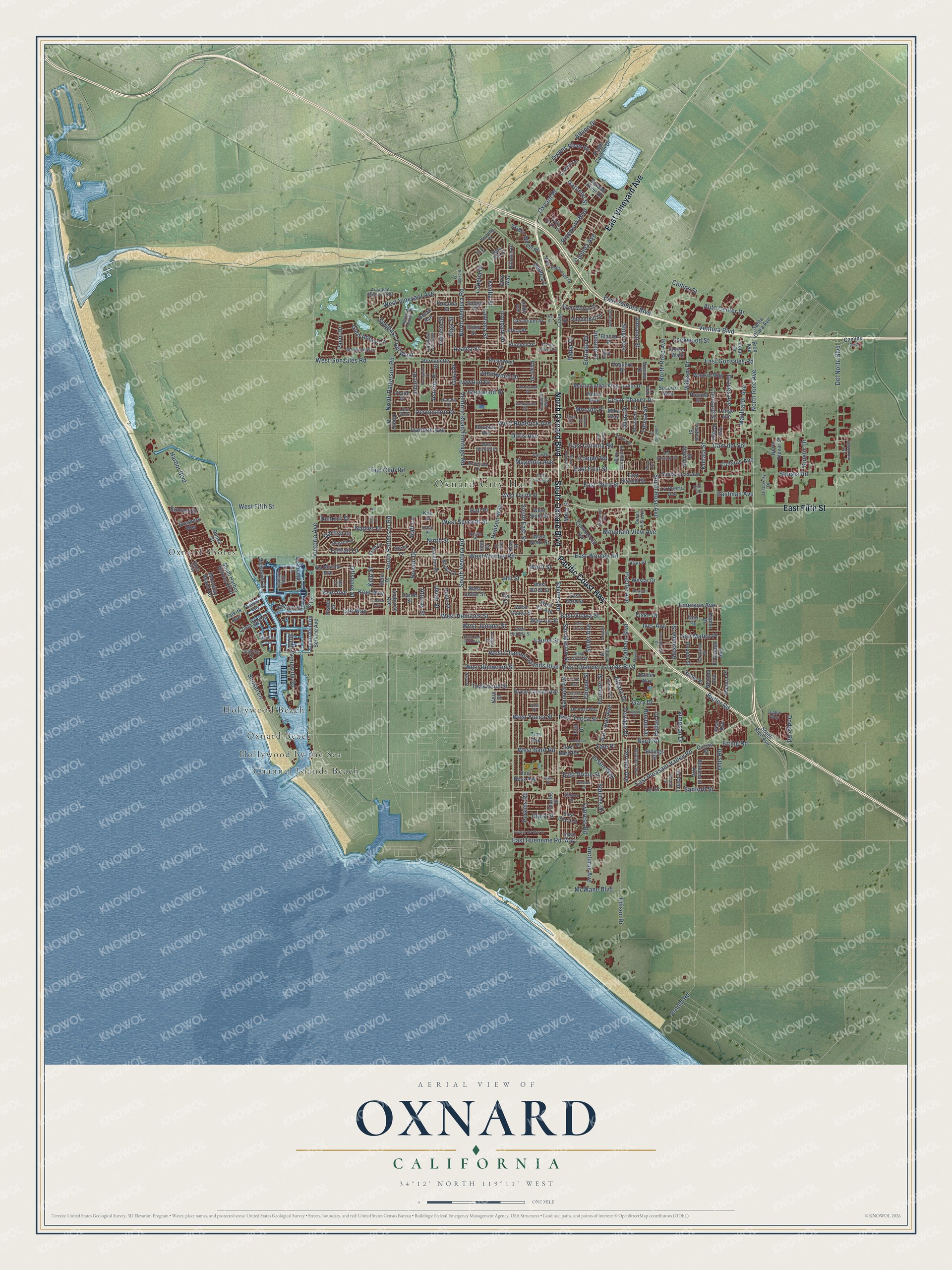
Oxnard, California Map Art
Building by building, with labeled streets and shaded relief.
12" x 18" Archival Matte Print
A Map of Home. A Work of Art.
Explore Oxnard, California from a whole new perspective. Created using aerial imagery and detailed geographic data, this map captures Oxnard building by building, with labeled streets, familiar landmarks, and shaded topographical relief that highlights the natural contours of the landscape.
Combining modern data with the timeless character of a vintage atlas, this map is just as interesting up close as it is beautiful on the wall. Whether you grew up in Oxnard, spent memorable years there, or call it home today, this unique map is a great way to celebrate a place that means something to you. Zoom in on the preview to look for your street, and then order a print to put your memories on the wall.
Three ways to hang it

Unframed archival matte, a black wood frame or a white wood frame.
Up close
Geography Worth Displaying
This map was created using accurate cartographic data and authoritative geographic sources, including the U.S. Geological Survey and the Census Bureau. The map brings together terrain, waterways, roads, and building detail. The majority of the streets are labeled, houses are accurately depicted, and the topography is derived from government sources. Combining local data with carefully composed color and shading leads to this beautifully detailed Oxnard artwork for your wall.
Rather than simply showing street outlines, we’ve included as many of the street names as we could reasonably fit on the map while keeping their names legible. Zoom in on the high resolution preview to see exactly what’s on the map. We truly set out to create a statement piece for anyone who loves Oxnard. So whether it’s for you, or a gift for someone you love, we hope this map of Oxnard brings back fond memories.
Read the story behind this map of Oxnard, California from 2026.

Find your street
Names on the Oxnard map
Every name below is printed on this map. Look for your street, your school, the park where you played, or the pond down the road.
Places and landmarks7
- Oxnard City Hall
- College Park
- Channel Islands Beach
- Oxnard Shores
- Hollywood Beach
- Oxnard Beach
- Hollywood by the Sea
Streets and roads338
- Pacific Coast Highway
- South Oxnard Boulevard
- North Oxnard Boulevard
- East Fifth Street
- East Vineyard Avenue
- East Pleasant Valley Road
- West Channel Islands Boulevard
- East Channel Islands Boulevard
- North Rice Avenue
- Cesar Chavez Drive
- East First Street
- East Hueneme Road
- East Ventura Boulevard
- Teresa Street
- Harbor Boulevard
- Saviers Road
- Simpson Drive
- William Drive
- West Wooley Road
- North Ventura Road
- West Fifth Street
- South Rose Avenue
- Victoria Avenue
- Cam del Sol
- West Hemlock Street
- West Gonzales Road
- West Vineyard Avenue
- Oxnard Bl
- East Gonzales Road
- North Rose Avenue
Show all 338 streets
- South East Street
- Del Norte Boulevard
- Ventura Boulevard
- Olds Road
- Doris Avenue
- South Ventura Road
- Teal Club Road
- Hill Street
- Sturgis Road
- North Patterson Road
- West Seventh Street
- Devonshire Drive
- South Patterson Road
- Entrada Drive
- Pacific Avenue
- Lombard Street
- Perkins Road
- Arcturus Avenue
- Oarfish Lane
- Auto Center Drive
- Edison Drive
- Eastman Avenue
- Ventura Road Frontage Road
- East Third Street
- Dunkirk Drive
- East Wooley Road
- Graves Avenue
- Cloyne Street
- Emerson Avenue
- Magnolia Avenue
- San Juan Avenue
- Taffrail Lane
- Patricia Street
- Sunset Lane
- West Juniper Street
- Spyglass Trail West
- Teakwood Street
- West Redwood Street
- Glenwood Drive
- Etting Road
- Mountain View Avenue
- Ivywood Drive
- Bard Road
- East Colonia Road
- West Roderick Avenue
- Riverpark Boulevard
- Offshore Street
- Kohala Street
- South Peninsula Road
- Ninth Street
- Lantana Street
- Snow Avenue
- Novato Drive
- Kentia Street
- Lockwood Street
- Joliet Place
- Glen Abbey Lane
- Statham Boulevard
- Ivanhoe Avenue
- Laurel Street
- McWane Boulevard
- Gisler Avenue
- Dallas Drive
- Owens River Drive
- San Marino Street
- Maulhardt Avenue
- Almanor Street
- Keel Avenue
- Keel Way
- Kelp Street
- East Yucca Street
- Lobelia Drive
- Justin Way
- Ives Avenue
- Albany Drive
- Sanford Street
- Alexander Street
- Janetwood Drive
- Fournier Street
- Ironbark Drive
- Azalea Street
- Samuel Avenue
- East Dollie Street
- Cooper Road
- Cypress Road
- San Mateo Place
- Arnold Road
- Isle Way
- Terrace Avenue
- Gary Drive
- Albion Drive
- Wolff Street
- Butler Road
- Clara Street
- West Yucca Street
- East Guava Street
- Apple Lane
- Squires Drive
- West Bard Road
- Astoria Place
- Naples Drive
- Garonne Street
- Olga Street
- Raft Lane
- Morado Place
- Celsius Avenue
- Hobson Way
- Kinetic Drive
- Gina Drive
- Colonia Avenue
- Boston Drive
- Ukiah Street
- Alturas Street
- Olivia Drive
- Terrace Drive
- Indiana Drive
- Sunset Drive
- Collins Street
- Dodge Road
- Bahia Drive
- Meta Street
- Pavin Drive
- Yale Place
- Hull Place
- Tulsa Drive
- Fiske Place
- South Rice Avenue
- Rice Avenue
- Kapalua Drive
- Mandalay Beach Road
- Holly Avenue
- South Harbor Service Boulevard
- West Birch Street
- West Iris Street
- East Second Street
- West Guava Street
- West Fir Avenue
- Martin Luther King Junior Drive
- Wagon Wheel Road
- Douglas Avenue
- Commercial Avenue
- East Bard Road
- Bryce Canyon Avenue
- West Cedar Street
- Ebony Drive
- West Ninth Street
- Bevra Avenue
- Rialto Street
- West Fourth Street
- Kiawah River Drive
- El Dorado Avenue
- Via Marina Avenue
- East Date Street
- West Sixth Street
- Wankel Way
- Latigo Avenue
- Santa Lucia Avenue
- Helm Drive
- Dupont Street
- Harbour Island Lane
- Beaumont Avenue
- Kings Canyon Drive
- Pso Ortega
- Stern Lane
- Indigo Place
- Saint Marys Drive
- North Elevar Street
- Escalon Drive
- Gibralter Street
- Carob Street
- Vanderbilt Drive
- South Victoria Service Avenue
- Viewpoint Drive
- Dunes Street
- Bernadette Street
- Geranium Place
- Costa de Oro
- Posada Drive
- Elder Street
- Seabridge Lane
- Kepler Drive
- Erica Place
- Solar Drive
- Rosewood Drive
- East Clara Street
- Madera Place
- Van Ness Avenue
- Socorro Way
- Westar Drive
- Falkirk Avenue
- Bluebell Place
- Ambrose Avenue
- La Puerta Avenue
- Lei Drive
- Petit Drive
- Vaquero Drive
- Breakers Way
- Kern Street
- Camino Avenue
- Hillrose Place
- Santa Clara Avenue
- Sonata Drive
- Lisbon Lane
- Rivas Lane
- Kelp Lane
- Blanca Place
- Charles Street
- Craig Drive
- Dover Street
- Billings Street
- Sutter Place
- Raider Way
- Fisher Drive
- Pear Avenue
- Kite Drive
- Titan Place
- Zion Avenue
- Nevada Avenue
- Holser Walk
- Pyrite Place
- Festivo Street
- Piedra Way
- Curran Street
- King Street
- Ives Place
- Ivory Way
- Irwin Way
- Mika Way
- Inlet Drive
- Elm Court
- Town Center Drive
- West Kamala Street
- Bermuda Dunes Place
- Palm Drive
- West Beverly Drive
- Arcadian Shores Trail
- West Esplanade Drive
- Lassen Street
- Brookwood Lane
- Oneida Place
- Geronimo Drive
- Rosalinda Drive
- East Olive Street
- Highland Avenue
- Camelot Way
- Spyglass Trail East
- De Anza Way
- Regatta Place
- Clinton Street
- North Marquita Street
- Buena Vista Avenue
- Lilac Walk
- Eastwood Drive
- Beacon Place
- Spectrum Circle
- Discovery Drive
- Eliza Court
- Citrus Grove Lane
- Falkirk Bay
- Jardin Drive
- Oyster Place
- Vida Lane
- Capri Way
- Estuary Way
- Yearling Place
- Upper Bay Drive
- Starfish Drive
- Spruce Drive
- Acacia Street
- Diablo Way
- Ilena Street
- Joya Drive
- Irving Drive
- Orlop Place
- Vine Place
- Lago Lane
- Ebb Court
- West Second Street
- Richmond Avenue
- East Iris Street
- Greenbrook Drive
- North Hayes Avenue
- Cuesta del Mar Drive
- Jason Place
- San Gorgonio Street
- Johnson Road
- Arcadia Street
- Anita Avenue
- Bottlebrush Place
- Valentina Drive
- Hazelwood Drive
- James Avenue
- Higuera Drive
- Evangeline Place
- Casa San Carlos Lane
- Webster Drive
- Nicklaus Street
- Jacktar Avenue
- Meridian Avenue
- Frank Avenue
- Andrea Drive
- Napa Street
- Fresca Drive
- First Street
- Ibiza Lane
- Stowe Drive
- Rosa Street
- Lake Drive
Names are listed as they appear on the printed map. Zoom into the product photos to find them.
About Oxnard, California
Oxnard is a city of 202,063 people in Ventura County, on the western edge of the fertile Oxnard Plain. Chumash people lived here before Europeans came, and in 1542 the explorer João Rodrigues Cabrilho claimed the land for Spain. After Mission San Buenaventura was founded in 1782, its herds of cattle grazed this ground. Californio ranchers held sway until California became a state in 1850, and around then American farmers moved in to plant barley and lima beans.
Henry T. Oxnard and his brothers Benjamin, James and Robert already ran a profitable sugar beet factory in Chino when they were persuaded to put up a $2 million plant on the plain inland from Port Hueneme. A town grew around it soon after the 1897 beet campaign. Henry hoped to call it zachari, the Greek word for sugar, but red tape wore him down, so he gave the town his own name. A railroad station opened in the spring of 1898 to serve the plant, and it drew Chinese, Japanese and Mexican workers. Oxnard became an incorporated city on June 30, 1903.
- Twin smokestacks, 1899 to 1959The giant red-brick sugar factory, known for its twin smokestacks, began running on August 19, 1899. That same year the Oxnard brothers, who never made their home in the city that bore their name, sold it and the Chino plant for nearly $4 million. A strike halted work in 1903, but the factory kept going until it closed on October 26, 1959.
- A library built in 1906The Oxnard Public Library building went up in 1906, and the library opened its doors to readers in 1907. The National Park Service calls the building a focal landmark for the city ever since it was built, and it joined the National Register in 1971.
- The Navy comes to the coastBefore and during World War II, the Navy set up bases at Point Mugu and Port Hueneme. They were placed here because Port Hueneme was the only major navigable port on the California coast between Los Angeles and San Francisco Bay. The bases then helped bring aerospace and communications companies to the area.
- Bud Smith builds a skylineMartin V. "Bud" Smith, who lived from 1916 to 2001, opened his first business, the Colonial House Restaurant, in 1941, and followed it with the Wagon Wheel Junction in 1947. Both are gone now, torn down in 1988 and 2011. Smith went on to help build Channel Islands Harbor and the towers of Topa Financial Plaza, where a fourteen-story high-rise opened in 1973 and a 21-story one in 1986, the two tallest buildings in the county.
Keep exploring California
Oxnard is one of 1,990 California towns we've mapped. Every dot on the map is a print of its own.
The search covers every state, California first.
Near Oxnard
Order 2 or more town maps and save 10%. Shown in the size and finish you picked above, so they hang as a set.
- Channel Islands Beach 12" x 18" / Archival Matte Print $39.99
- Port Hueneme 12" x 18" / Archival Matte Print $39.99
- El Rio 12" x 18" / Archival Matte Print $39.99


More maps nearby: Ventura, Saticoy, Camarillo, Somis and Santa Paula.
The art of mapping a place
How This Map Was Made
Real places. Remarkable detail. Discover the layers that turn geographic data into a map of home.

The view from above
Aerial imagery reveals the character of the land: woodland, open fields, and the patterns of a place.

The shape of the land
Elevation data brings hills, valleys, and subtle changes in the landscape into view.

The details of home
Roads, waterways, and building footprints come together to make the map feel unmistakably local.

Geography becomes art
Considered color, shading, and typography bring the layers together in a map made for your wall.


Process illustrated with Mendon, Massachusetts. Aerial imagery: USDA NAIP. Terrain: USGS 3D Elevation Program. Map details and finished artwork: KNOWOL.
The Details
About This Print
Choose an archival matte print, or a black or white Ayous wood frame. The archival matte print is unframed.
Select your size and finish above to see the matching product image and price.
Materials & Craftsmanship
A contemporary map with the character of a classic atlas, printed on archival matte paper. Optional frames are made from Ayous wood.
Your printed map does not include the watermark shown in the full-map preview.
Shipping & Delivery
Free shipping within the United States. Every print is made to order in the USA.
Buying a gift? Add a note in your cart and we'll include it. We never put prices in the package.
Prints ship within 2 to 3 business days. Allow 7 to 10 days total from ordering for delivery. Timing may vary during holidays or periods of high order volume.
Read our shipping policy.
Returns and damaged prints
Each print is made to order. Change-of-mind refunds are not available after production.
If your print arrives damaged, misprinted or incorrect, contact support@knowol.com within 30 days of receiving it. Include your order number, photos and a description of the issue.
Read our full refund and replacement policy. For questions about your order, email support@knowol.com.