


Search for another town


Free U.S. delivery 7 to 10 days after you order
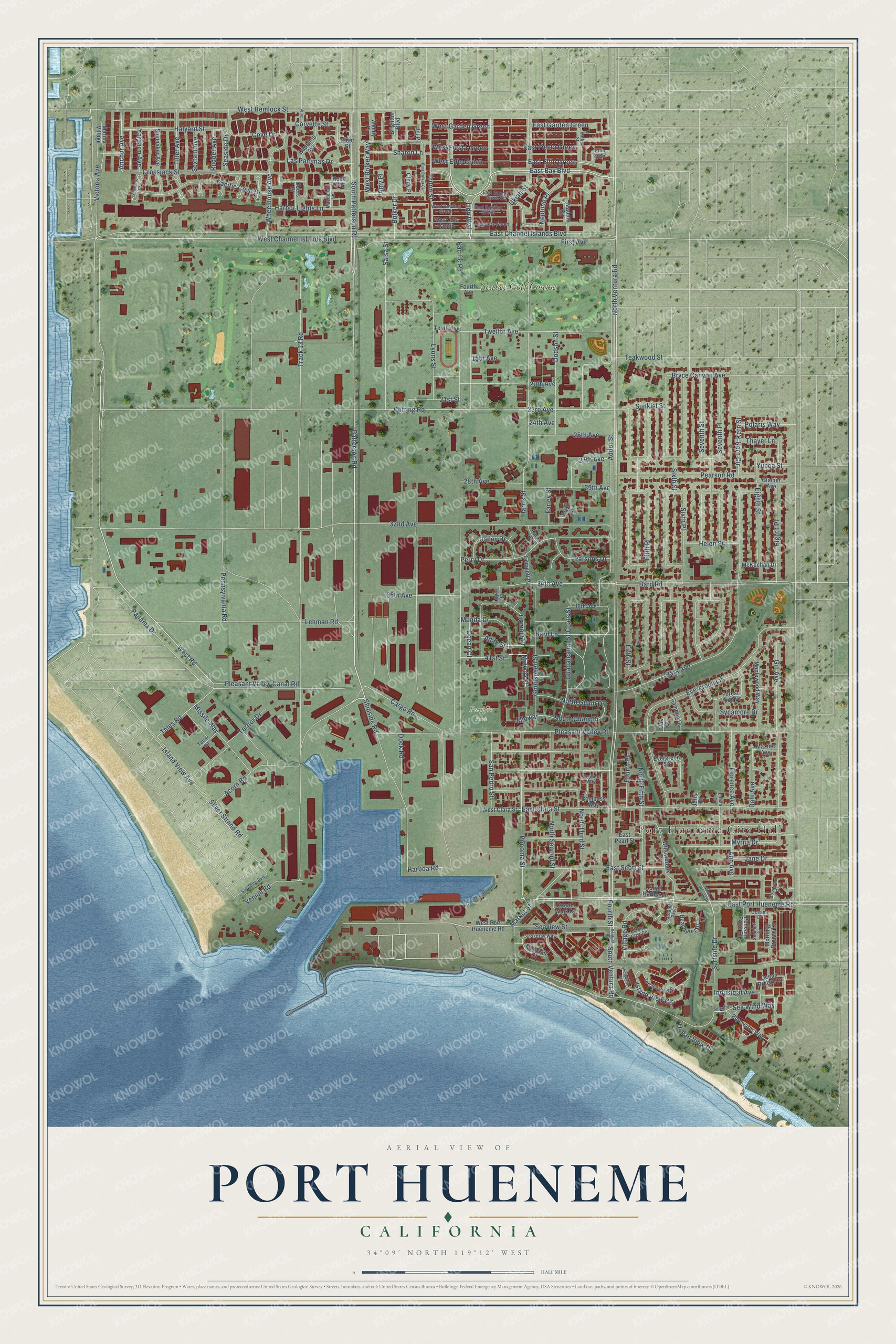
Port Hueneme, California Map Art
Building by building, with labeled streets and shaded relief.
12" x 18" Archival Matte Print
A Map of Home. A Work of Art.
Explore Port Hueneme, California from a whole new perspective. Created using aerial imagery and detailed geographic data, this map captures Port Hueneme building by building, with labeled streets, familiar landmarks, and shaded topographical relief that highlights the natural contours of the landscape.
Combining modern data with the timeless character of a vintage atlas, this map is just as interesting up close as it is beautiful on the wall. Whether you grew up in Port Hueneme, spent memorable years there, or call it home today, this unique map is a great way to celebrate a place that means something to you. Zoom in on the preview to look for your street, and then order a print to put your memories on the wall.
Three ways to hang it

Unframed archival matte, a black wood frame or a white wood frame.
Up close
Geography Worth Displaying
This map was created using accurate cartographic data and authoritative geographic sources, including the U.S. Geological Survey and the Census Bureau. The map brings together terrain, waterways, roads, and building detail. The majority of the streets are labeled, houses are accurately depicted, and the topography is derived from government sources. Combining local data with carefully composed color and shading leads to this beautifully detailed Port Hueneme artwork for your wall.
Rather than simply showing street outlines, we’ve included as many of the street names as we could reasonably fit on the map while keeping their names legible. Zoom in on the high resolution preview to see exactly what’s on the map. We truly set out to create a statement piece for anyone who loves Port Hueneme. So whether it’s for you, or a gift for someone you love, we hope this map of Port Hueneme brings back fond memories.
Read the story behind this map of Port Hueneme, California from 2026.

Find your street
Names on the Port Hueneme map
Every name below is printed on this map. Look for your street, your school, the park where you played, or the pond down the road.
Places and landmarks3
- Port Hueneme City Hall
- Pacific Park
- Seabee Golf Course
Streets and roads205
- West Road
- Patterson Road
- East Bay Boulevard
- Cargo Road
- Neptune Place
- Lido Boulevard
- East Channel Islands Boulevard
- Anchor Avenue
- Midway Street
- West Channel Islands Boulevard
- East Port Hueneme Road
- North Ventura Road
- East Elfin Green
- Tales Road
- Cutting Road
- South Guam Drive
- Coats Street
- Track 13 Road
- Pacific Road
- 32nd Avenue
- Addor Street
- Pleasant Valley Road
- Surfside Drive
- Bard Road
- West Hemlock Street
- Sixth Street
- Fifth Street
- Park Avenue
- Seventh Street
- Evergreen Lane
Show all 205 streets
- East Clara Street
- First Avenue
- Sixth Place
- South Patterson Road
- Island View Avenue
- Fifth Place
- 23rd Avenue
- Seventh Place
- Pennsylvania Road
- Lehman Road
- Fourth Street
- South Ventura Road
- Bolker Drive
- East Scott Street
- Shipside Road
- Harboa Road
- Salsa Street
- Gill Avenue
- Ponoma Street
- Perry Drive
- 34th Avenue
- Twelfth Avenue
- North Third Street
- Crossjack Street
- Florence Avenue
- Island View Circle
- Cove Drive
- Goodspeed Street
- Pearson Road
- East Garden Green
- Silver Strand Road
- Pacific Cove Drive
- Panama Drive
- North Fifth Street
- Victoria Avenue
- Homoja Drive
- Eighth Place
- Ukiah Street
- West Garden Green
- Harris Street
- Bard Lane
- Seaview Street
- Myrna Drive
- 35th Avenue
- Halyard Street
- West Bolker Way
- Ann Avenue
- Triton Street
- Acorn Road
- 41st Street
- Terrior Drive
- East Fiesta Green
- North Second Street
- Village Road
- 20th Avenue
- Eighth Street
- North Guam Drive
- Missile Way
- 29th Avenue
- Pleasant Valley Canal Road
- Guadalcanal Street
- Yardarm Avenue
- 25th Avenue
- 15th Avenue
- Sycamore Drive
- Market Street
- Dodson Street
- San Pedro Street
- Munda Drive
- Harbor Lights Lane
- Jelley Drive
- Midway
- Wheelhouse Avenue
- Ocean Court
- Parsons Drive
- Las Palomas Drive
- Bryce Canyon Avenue
- Dock Road
- Venice Road
- Seaside Drive
- 28th Avenue
- Lyons Street
- Tiller Avenue
- Sea Wind Way
- West Fiesta Green
- Industrial Avenue
- West Elfin Green
- Dahl Avenue
- Fourth Place
- Kern Street
- Sharon Lane
- Adak Street
- Jane Drive
- Helen Street
- Kern Circle
- 21st Street
- Polaris Way
- Sunkist Street
- Teakwood Street
- Corvette Street
- Ocean View Drive
- Sextant Avenue
- Rudder Avenue
- 27th Avenue
- Thayer Lane
- Farley Street
- Yucca Street
- 24th Avenue
- Amy Place
- West Port Hueneme Road
- East Pearl Street
- Willowbrook Drive
- Maplewood Way
- Evergreen Square
- Pearl Court
- Forest Loop Drive
- Fourth Avenue
- Beachport Drive
- Spinnaker Avenue
- Marina Village
- Bluewater Way
- Ocean Walk Court
- Morning Breeze Lane
- Madera Circle
- Captains Avenue
- Ocean Breeze Drive
- West Alta Green
- West Clara Street
- McKeehan Drive
- Camelia Drive
- Brighton Boulevard
- Shell Harbor Lane
- 36th Avenue
- Glacier Avenue
- Endicott Place
- Mainsail Court
- Compass Way
- Obers Place
- Tenth Avenue
- Maxine Avenue
- Wendy Place
- Reed Way
- Pelican Point Court
- Cindy Place
- Parks Street
- Leyte Street
- Fleet Street
- Jerry Drive
- Jill Place
- Oak Court
- Elfin Green
- Terrace View Place
- Courtyard Drive
- Balboa Street
- Seaspray Way
- Sawtelle Avenue
- West Bowling Green
- East Bowling Green
- East Alta Green
- East Carmel Green Street
- Macdonald Lane
- Oceana Drive
- Seabluff Drive
- Santa Cruz Circle
- Tarter Road
- Moranda Parkway
- Tugboat Way
- Lillian Drive
- Ventura Road
- Seawind Way
- East Bolker Circle
- Shoreview Drive
- Seashore Court
- North Surfside Drive
- Jetty
Names are listed as they appear on the printed map. Zoom into the product photos to find them.
About Port Hueneme, California
Port Hueneme is a city of 21,954 people in Ventura County, on the Santa Barbara Channel at the southwest edge of the Oxnard Plain. Its name is the Spanish spelling of Wene Me, a Ventureño Chumash name that means "Resting Place." Juan Rodríguez Cabrillo sailed this coast and the nearby Channel Islands in October 1542.
Thomas Bard learned that a deep submarine canyon reached close to shore at Point Hueneme, and in 1871 he used that depth to build the Hueneme Wharf. Until the Montalvo Cutoff carried the railroad to Oxnard, the wharf was the main link to the outside world for the part of the county south of the Santa Clara River. From 1871 to 1895, only one Pacific Coast port shipped more grain, and the town's street grid was laid out in 1888.
- Wynema, then Port HuenemeDuring the 1800s the local postmaster gave the post office the name Wynema, borrowed from his own company, the Wynema Lighter Co. The town officially took the name Port Hueneme in 1939 and incorporated as a city on March 24, 1948. In 2021 the city council began a move to rename it Hueneme Beach to draw tourists, but the idea was voted down in November 2022.
- A deep-water Navy harborDuring World War II the U.S. Navy took control of the harbor, and today Naval Base Ventura County shares the city with the Port of Hueneme. It is the only deep-water port between Los Angeles and San Francisco, and the only harbor the Navy controls between San Diego Bay and Puget Sound. More than 3.3 billion bananas pass through it each year, which the port has celebrated with its Banana Festival since 2011.
- The oldest women's clubhouseThe Women's Improvement Club of Hueneme has the oldest women's clubhouse in Ventura County, and the building is still used as a clubhouse. It joined the National Register in 1989.
- Harbor Days, 1950 to 2001For 51 years the Harbor Days Festival and Parade filled the town with bands, kite-flying and sand-sculpture contests, and vendor booths. Rising insurance costs, food handling rules and fading city support ended it in 2001. Since 1998 the city has held a two-day beach festival each August at 550 East Surfside Drive.
- A sundial for Flight 261On January 31, 2000, Alaska Airlines Flight 261 went down in the Pacific between Port Hueneme and Anacapa Island, and all 88 people aboard died. The wreckage was recovered from the neighboring Navy base. With the families' approval, Santa Barbara artist James "Bud" Bottoms designed a memorial sundial for the beach near the crash site, with the victims' names on bronze plates. Each January 31 at 16:22, its shadow falls on a memorial plaque.
Keep exploring California
Port Hueneme is one of 1,990 California towns we've mapped. Every dot on the map is a print of its own.
The search covers every state, California first.
Near Port Hueneme
Order 2 or more town maps and save 10%. Shown in the size and finish you picked above, so they hang as a set.
- Channel Islands Beach 12" x 18" / Archival Matte Print $39.99
- Oxnard 12" x 18" / Archival Matte Print $39.99
- El Rio 12" x 18" / Archival Matte Print $39.99


More maps nearby: Ventura, Saticoy, Camarillo, Somis and Casa Conejo.
The art of mapping a place
How This Map Was Made
Real places. Remarkable detail. Discover the layers that turn geographic data into a map of home.

The view from above
Aerial imagery reveals the character of the land: woodland, open fields, and the patterns of a place.

The shape of the land
Elevation data brings hills, valleys, and subtle changes in the landscape into view.

The details of home
Roads, waterways, and building footprints come together to make the map feel unmistakably local.

Geography becomes art
Considered color, shading, and typography bring the layers together in a map made for your wall.


Process illustrated with Mendon, Massachusetts. Aerial imagery: USDA NAIP. Terrain: USGS 3D Elevation Program. Map details and finished artwork: KNOWOL.
The Details
About This Print
Choose an archival matte print, or a black or white Ayous wood frame. The archival matte print is unframed.
Select your size and finish above to see the matching product image and price.
Materials & Craftsmanship
A contemporary map with the character of a classic atlas, printed on archival matte paper. Optional frames are made from Ayous wood.
Your printed map does not include the watermark shown in the full-map preview.
Shipping & Delivery
Free shipping within the United States. Every print is made to order in the USA.
Buying a gift? Add a note in your cart and we'll include it. We never put prices in the package.
Prints ship within 2 to 3 business days. Allow 7 to 10 days total from ordering for delivery. Timing may vary during holidays or periods of high order volume.
Read our shipping policy.
Returns and damaged prints
Each print is made to order. Change-of-mind refunds are not available after production.
If your print arrives damaged, misprinted or incorrect, contact support@knowol.com within 30 days of receiving it. Include your order number, photos and a description of the issue.
Read our full refund and replacement policy. For questions about your order, email support@knowol.com.