
Search for another town


Free U.S. delivery 7 to 10 days after you order
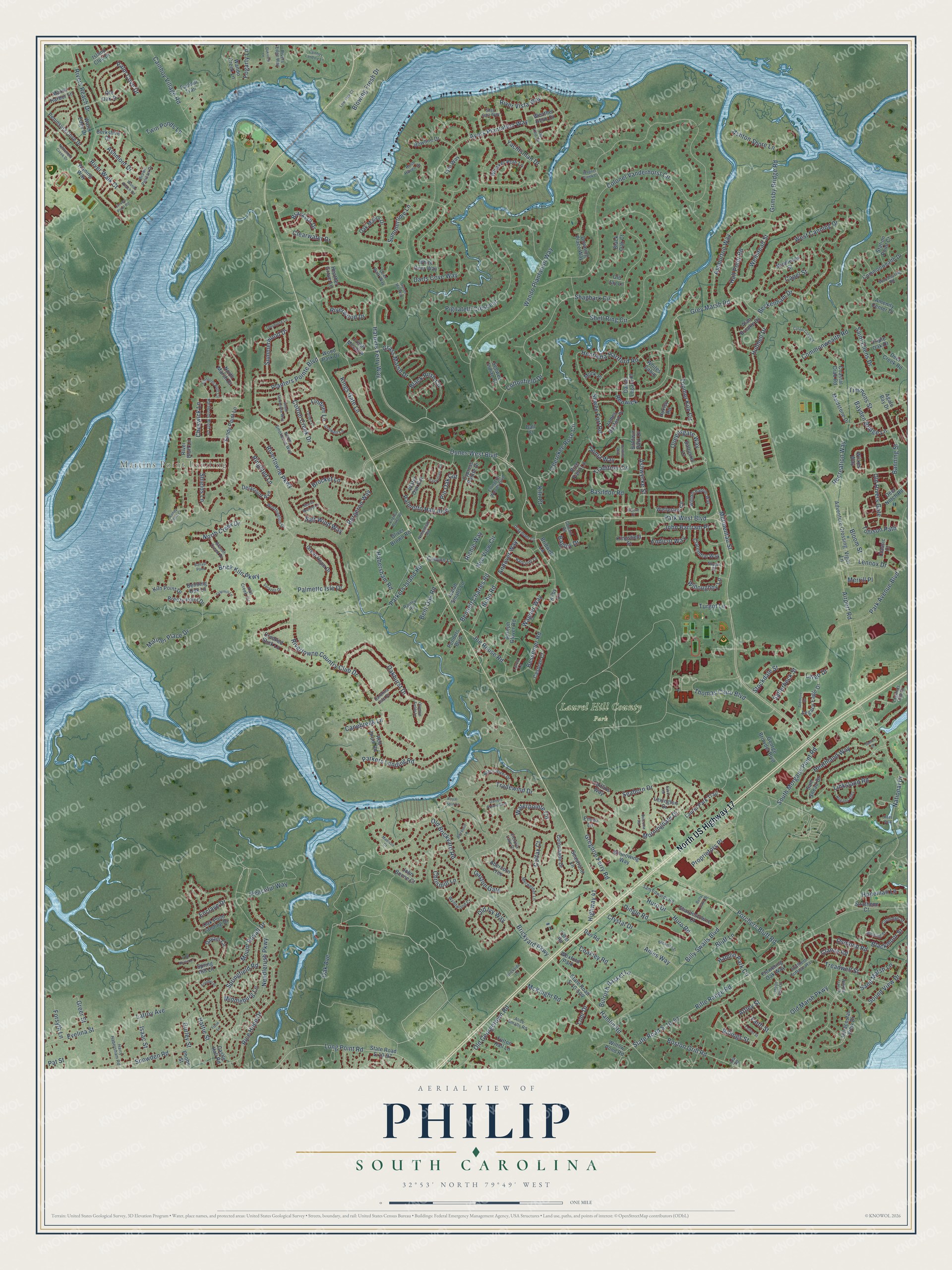
Philip, South Carolina Map Art
Building by building, with labeled streets and shaded relief.
12" x 18" Archival Matte Print
A Map of Home. A Work of Art.
Explore Philip, South Carolina from a whole new perspective. Created using aerial imagery and detailed geographic data, this map captures Philip building by building, with labeled streets, familiar landmarks, and shaded topographical relief that highlights the natural contours of the landscape.
Combining modern data with the timeless character of a vintage atlas, this map is just as interesting up close as it is beautiful on the wall. Whether you grew up in Philip, spent memorable years there, or call it home today, this unique map is a great way to celebrate a place that means something to you. Zoom in on the preview to look for your street, and then order a print to put your memories on the wall.
Three ways to hang it

Unframed archival matte, a black wood frame or a white wood frame.
Up close
Geography Worth Displaying
This map was created using accurate cartographic data and authoritative geographic sources, including the U.S. Geological Survey and the Census Bureau. The map brings together terrain, waterways, roads, and building detail. The majority of the streets are labeled, houses are accurately depicted, and the topography is derived from government sources. Combining local data with carefully composed color and shading leads to this beautifully detailed Philip artwork for your wall.
Rather than simply showing street outlines, we’ve included as many of the street names as we could reasonably fit on the map while keeping their names legible. Zoom in on the high resolution preview to see exactly what’s on the map. We truly set out to create a statement piece for anyone who loves Philip. So whether it’s for you, or a gift for someone you love, we hope this map of Philip brings back fond memories.
Read the story behind this map: Detailed Map of Philip, South Carolina.

Find your street
Names on the Philip map
Every name below is printed on this map. Look for your street, your school, the park where you played, or the pond down the road.
Places and landmarks3
- Martins Point Landing
- Laurel Hill County Park
- Wexford Park
Streets and roads342
- North US Highway 17
- Park West Boulevard
- Harpers Ferry Way
- Wando Plantation Way
- South Morgans Point Road
- Dunes West Boulevard
- Rivertowne Parkway
- Cottonfield Drive
- Old Ivy Way
- Queensgate Way
- Needlerush Parkway
- Heathland Way
- National Drive
- Rivers Reach Drive
- Grey Marsh Road
- Airport Road
- Bayden Bridge Lane
- Morningdale Drive
- Colonel Vanderhorst Circle
- Rivertowne Country Club Drive
- State Road S-10-51
- Pignatelli Crescent
- Shell Ring Circle
- Porchers Bluff Road
- Brickyard Parkway
- Ayers Plantation Way
- Cherokee Rose Circle
- Rifle Range Road
- River Vista Way
- Kings Gate Lane
Show all 342 streets
- Palmetto Hall Boulevard
- Beckenham Drive
- Yachtsman Drive
- Mount Royall Drive
- Henrietta Hartford Road
- Bessemer Road
- Darts Cove Way
- Park Avenue Boulevard
- Billy Swails Boulevard
- Long Point Road
- Andover Way
- Old Marsh Parkway
- Toomer Kiln Circle
- Hamlin Road
- Sand Marsh Lane
- Thomas Cairo Boulevard
- Shagbark Circle
- Linksland Road
- Ashburton Way
- Palmetto Isle Drive
- West Canning Drive
- Salt Wind Way
- Oakhurst Drive
- Riverwood Drive
- Oak Avenue
- Snowden Road
- Rice Hope Drive
- Palm Cove Drive
- Cainhoy Village Road
- Basildon Road
- Treadwell Street
- Parkers Landing Road
- Old Brickyard Road
- Billings Street
- Tradewind Drive
- Waterpointe Circle
- Black Rush Circle
- Brick Kiln Parkway
- Gregorie Ferry Road
- Boston Grill Road
- Tradition Circle
- Old Georgetown Road
- Mariner Place Drive
- Chrismill Lane
- Springfield Road
- Willoughby Lane
- Sewee Fort Road
- Clearwater Drive
- Ashton Shore Lane
- Joe Rouse Road
- Saint Ellens Drive
- Huro Drive
- Huro Road
- Bulrush Basket Lane
- Seaborn Drive
- Gaston Gate
- Bergeron Way
- Hall Point Road
- Wellstead Street
- Sound View Drive
- Cheswick Lane
- Banning Street
- Renwick
- Blackmoor Street
- Hubbell Drive
- John Bartram Place
- Capel Street
- Planters Pointe Boulevard
- Parkers Island Road
- North Creek Drive
- Grimsby Bridge Road
- Crystal Drive
- Summertime Lane
- Recreation Way
- Dingle Road
- Blowing Fresh Drive
- Summerwood Drive
- Bluff Lane
- Evelina Street
- Cotton Creek Drive
- Shields Lane
- Commonwealth Road
- Hamlin Park Circle
- Lennox Drive
- Ashmont Drive
- Mermentau Street
- Middleburg Lane
- Bagley Drive
- Grass Marsh Drive
- Bennett Charles Road
- Bobo Road
- Proprietors Place
- Tollison Path
- Timmons Street
- River Walk Court
- Brackish Drive
- Stockdale Street
- Peaceful Way
- Enclave Drive
- Habersham Road
- Colfax Court
- Sonja Way
- Lindner Lane
- Twin Ponds Lane
- Endicot Way
- Latroy Avenue
- Ringsted Lane
- Bloom Street
- Attley Street
- Old Rivers Gate
- Ashwycke Street
- Bent Oak Road
- Hopeman Lane
- McKnight Road
- Salterbeck Street
- Isaac Street
- Forsyth Lane
- Ames Way
- Coakley Road
- Pin Oak Cut
- Canebreak Lane
- Greer Street
- Fogarty Lane
- Brocket Lane
- Osmond Road
- Gurley Street
- Wagner Way
- Largo Drive
- Nye View Circle
- Clancy Road
- Richie Way
- Highway 41
- Kiln Court
- Merrill Place
- Turgot Lane
- Lohr Drive
- Hattie Street
- Faith Street
- Pat Street
- Wellesley Circle
- Island Club Drive
- Heather Grove Lane
- Sandy Point Lane
- State Road S-10-97
- State Road S-10-504
- Oak Point Landing Drive
- Commonwealth Drive
- Maidstone Drive
- Cypress Pointe Drive
- Oak Manor Drive
- Laurel Park Trail
- Crooked Stick Lane
- Intracostal View Drive
- River Bluff Lane
- Colonnade Drive
- Agate Bay Drive
- Water Edge Drive
- North Marsh Drive
- James Basford Place
- Lexington Drive
- John Boone Court
- Peninsula Cove Drive
- Great Hope Drive
- Joseph Glover Road
- Seastrand Lane
- Legacy Eagle Drive
- Davant Circle
- Adventure Crossing
- Rice Field Lane
- Downing Place Way
- Kingsfield Street
- Coastal Crab Road
- Whisker Pole Lane
- Station Point Court
- Clarendon Way
- Winnowing Way
- Castle Hall Road
- Oliver Brown Road
- Fulton Hall Lane
- Flowering Oak Way
- Sharpestowne Court
- Berkshire Drive
- Delacourt Avenue
- Wando Creek Lane
- Daniel Legare Place
- Red Drum Road
- Abercorn Trce
- Willow Pond Road
- Breezy Point Drive
- Deer Creek Road
- Caspian Court
- George Browder Boulevard
- Water Oak Cut
- Famhill Trail
- Seewee Indian Court
- Ole Oak Drive
- Wilkes Way
- Sam Snead Drive
- Dan Road
- Bending Oak Lane
- Baltusrol Lane
- Black Oak Court
- Fresh Meadow
- Marsh Harbor Lane
- Alan Brooke Drive
- Kiln Point Drive
- Middlesex Street
- Bridwell Lane
- Canyon Lane
- White Deer Way
- Caitlins Way
- Bowline Drive
- Amenity Center Drive
- Weather Helm Drive
- Wood Park Drive
- Deer Notch Road
- Isaiah Smalls Lane
- Triple Oak Drive
- Penders Boulevard
- Strathene Court
- Whites Cabin
- Baldwin Park Drive
- Spring Hill Lane
- Classic Court
- Waning Way
- Lyle Way
- Phobe Street
- Monk Place
- Huxley Road
- Vigor Lane
- Kilby Lane
- Old Jay Lane
- Emma Lane
- Ball Court
- Tiller Road
- Legends Club Drive
- Victoria Lake Drive
- Ellington Woods Boulevard
- North Smokerise Way
- Merwether Lane
- William Hapton Way
- Rush Haven Drive
- Black River Drive
- Coolidge Street
- Sam Edwards Road
- Crowell Lane
- Worthington Drive
- Stay Sail Way
- Hartfords Bluff Lane
- Southern Cottage Way
- Branch Creek Drive
- Harry Habersham Road
- Trip Line Drive
- Bancroft Lane
- Alice Smalls Road
- Woodspring Road
- Carolina Isle Drive
- Wynnwood Court
- Draymohr Court
- Rainey Road
- Kiln Creek Circle
- Nehemiah Road
- Whiting Street
- Conant Road
- Brown Pelican Drive
- Rivers Edge Way
- Deer Walk Way
- Larch Lane
- Thayer Place
- Ida Road
- Madison Court
- Nelliefield Creek Drive
- Lagoon Park Circle
- Wando Reach Road
- Daniels Pointe Boulevard
- Jervey Point Road
- Royal Trace Lane
- Hartfords Bluff Circle
- Sassafrass Circle
- Backman Street
- South Smokerise Way
- Hogans Alley
- Costal Crab Road
- Ardmore Drive
- Collier Street
- Cainhoy Landing Lane
- Arundel Place
- Bella Oaks Drive
- Oakview Lane
- Brickmill Lane
- Turben Place
- Thornrose Lane
- Dunes Mill Way
- Sandy Point Court
- Wild Horse Lane
- Wagner Creek Court
- Heidiho Way
- Virginia Rouse Road
- Claymill Lane
- Marsh Breeze Lane
- Tison Lane
- Low Tide Court
- Ballast Point
- Sarazen Drive
- Balcome Road
- Olympia Fields Lane
- Tabor Road
- Brickside Lane
- Rees Row
- Walking Trail Court
- Ketene Court
- Spoon Court
Names are listed as they appear on the printed map. Zoom into the product photos to find them.
Keep exploring South Carolina
Philip is one of 540 South Carolina towns we've mapped. Every dot on the map is a print of its own.
The search covers every state, South Carolina first.
Near Philip
Order 2 or more town maps and save 10%. Shown in the size and finish you picked above, so they hang as a set.
- Daniel Island 12" x 18" / Archival Matte Print $39.99
- Mount Pleasant 12" x 18" / Archival Matte Print $39.99
- Isle of Palms 12" x 18" / Archival Matte Print $39.99


More maps nearby: Sullivan's Island, Charleston, Hampton Park Terrace, Awendaw and Hanahan.
The art of mapping a place
How This Map Was Made
Real places. Remarkable detail. Discover the layers that turn geographic data into a map of home.

The view from above
Aerial imagery reveals the character of the land: woodland, open fields, and the patterns of a place.

The shape of the land
Elevation data brings hills, valleys, and subtle changes in the landscape into view.

The details of home
Roads, waterways, and building footprints come together to make the map feel unmistakably local.

Geography becomes art
Considered color, shading, and typography bring the layers together in a map made for your wall.


Process illustrated with Mendon, Massachusetts. Aerial imagery: USDA NAIP. Terrain: USGS 3D Elevation Program. Map details and finished artwork: KNOWOL.
The Details
About This Print
Choose an archival matte print, or a black or white Ayous wood frame. The archival matte print is unframed.
Select your size and finish above to see the matching product image and price.
Materials & Craftsmanship
A contemporary map with the character of a classic atlas, printed on archival matte paper. Optional frames are made from Ayous wood.
Your printed map does not include the watermark shown in the full-map preview.
Shipping & Delivery
Free shipping within the United States. Every print is made to order in the USA.
Buying a gift? Add a note in your cart and we'll include it. We never put prices in the package.
Prints ship within 2 to 3 business days. Allow 7 to 10 days total from ordering for delivery. Timing may vary during holidays or periods of high order volume.
Read our shipping policy.
Returns and damaged prints
Each print is made to order. Change-of-mind refunds are not available after production.
If your print arrives damaged, misprinted or incorrect, contact support@knowol.com within 30 days of receiving it. Include your order number, photos and a description of the issue.
Read our full refund and replacement policy. For questions about your order, email support@knowol.com.