


Search for another town


Free U.S. delivery 7 to 10 days after you order
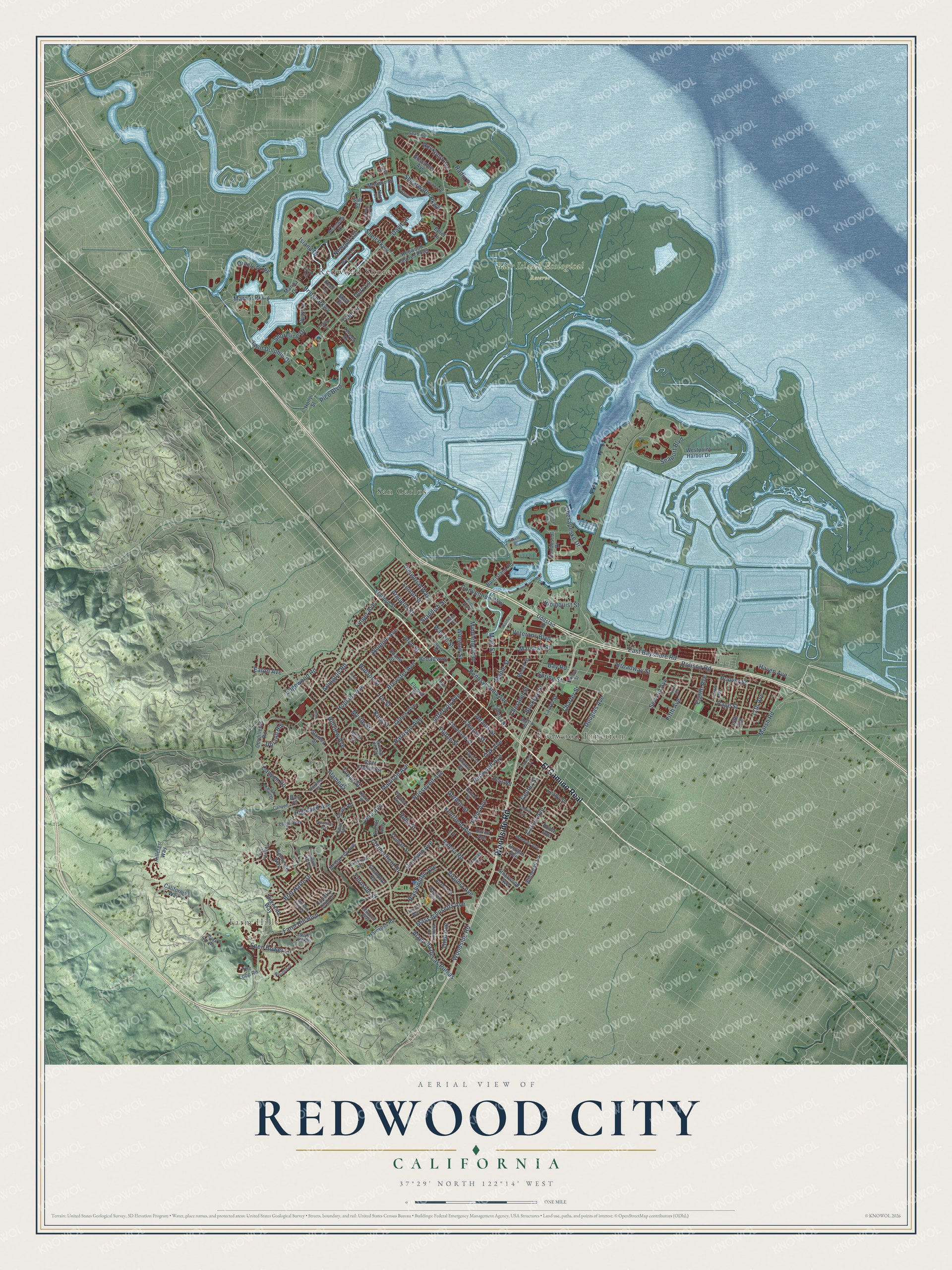
Redwood City, California Map Art
Building by building, with labeled streets and shaded relief.
12" x 18" Archival Matte Print
A Map of Home. A Work of Art.
Explore Redwood City, California from a whole new perspective. Created using aerial imagery and detailed geographic data, this map captures Redwood City building by building, with labeled streets, familiar landmarks, and shaded topographical relief that highlights the natural contours of the landscape.
Combining modern data with the timeless character of a vintage atlas, this map is just as interesting up close as it is beautiful on the wall. Whether you grew up in Redwood City, spent memorable years there, or call it home today, this unique map is a great way to celebrate a place that means something to you. Zoom in on the preview to look for your street, and then order a print to put your memories on the wall.
Three ways to hang it

Unframed archival matte, a black wood frame or a white wood frame.
Up close
Geography Worth Displaying
This map was created using accurate cartographic data and authoritative geographic sources, including the U.S. Geological Survey and the Census Bureau. The map brings together terrain, waterways, roads, and building detail. The majority of the streets are labeled, houses are accurately depicted, and the topography is derived from government sources. Combining local data with carefully composed color and shading leads to this beautifully detailed Redwood City artwork for your wall.
Rather than simply showing street outlines, we’ve included as many of the street names as we could reasonably fit on the map while keeping their names legible. Zoom in on the high resolution preview to see exactly what’s on the map. We truly set out to create a statement piece for anyone who loves Redwood City. So whether it’s for you, or a gift for someone you love, we hope this map of Redwood City brings back fond memories.
Read the story behind this map of Redwood City, California from 2026.

Find your street
Names on the Redwood City map
Every name below is printed on this map. Look for your street, your school, the park where you played, or the pond down the road.
Places and landmarks5
- Farm Hills
- Bair Island Ecological Reserve
- Redwood Shores
- San Carlos
- Redwood Junction
Streets and roads197
- Woodside Road
- El Camino Real
- Redwood Avenue
- Upland Road
- Rolison Road
- Jefferson Avenue
- Seaport Boulevard
- Alameda de Las Pulgas
- Alameda
- Broadway Street
- Edgewood Road
- Brewster Avenue
- East Bayshore Road
- Bay Road
- Roosevelt Avenue
- Marine Parkway
- Whipple Avenue
- Hudson Street
- Bridge Parkway
- Farm Hill Boulevard
- Hopkins Avenue
- Veterans Boulevard
- Middlefield Road
- Maple Street
- James Avenue
- Madison Avenue
- Twin Dolphin Drive
- Vera Avenue
- Main Street
- Oak Avenue
Show all 197 streets
- Valota Road
- Spring Street
- Bret Harte Drive
- Clinton Street
- Fernside Street
- King Street
- Iris Street
- Virginia Avenue
- Fulton Street
- Myrtle Street
- Page Street
- Hoover Street
- Harrison Avenue
- Kentfield Avenue
- Connecticut Drive
- Haven Avenue
- Goodwin Avenue
- Shearwater Parkway
- Marshall Street
- Palm Avenue
- Chestnut Street
- Oracle Parkway
- Douglas Avenue
- Ruby Street
- Canyon Road
- Arguello Street
- Charter Street
- Arlington Road
- Winslow Street
- Newport Circle
- Convention Way
- Topaz Street
- Massachusetts Avenue
- Shell Parkway
- Marsh Road
- Davit Lane
- Adams Street
- Hillview Avenue
- Shoreline Drive
- Pennsylvania Avenue
- Washington Avenue
- Gordon Street
- Highland Avenue
- Carlos Avenue
- Fifth Avenue
- Warren Street
- Broadway
- Chesapeake Drive
- Eden Bower Lane
- Second Avenue
- Blomquist Street
- Rockport Avenue
- Radio Road
- Industrial Way
- Arch Street
- Lenolt Street
- Buckeye Street
- Ohio Avenue
- Center Street
- 17th Avenue
- Pico Boulevard
- Island Drive
- Eighth Avenue
- Tiller Lane
- Finger Avenue
- Eaton Avenue
- Standish Street
- Dory Lane
- Redwood Shores Parkway
- Salt Court
- Grand Street
- Saint Francis Street
- McGarvey Avenue
- California Way
- Beech Street
- Cleveland Street
- Elwood Street
- Country Club Drive
- Crompton Road
- Westpoint Harbor Drive
- Duane Street
- Stafford Street
- Atherwood Avenue
- Roble Avenue
- 15th Avenue
- Laurel Street
- Bair Island Road
- Gossamer Avenue
- Cordilleras Road
- Monaco Drive
- Inner Circle
- Oddstad Drive
- Seminole Way
- Whitehall Lane
- Union Avenue
- Lathrop Street
- Truman Street
- Quay Lane
- Edgecliff Way
- Skiff Circle
- Harcross Road
- Hillcrest Way
- Penobscot Drive
- Horgan Avenue
- Leahy Street
- Teredo Drive
- The Loop Road
- Hess Road
- Bain Place
- Dover Road
- Holly Street
- Stanley Street
- Euclid Avenue
- Marina Drive
- Egret Lane
- Keel Lane
- Oak Knoll Drive
- Wheeler Avenue
- Hampton Avenue
- Anamor Street
- Junipero Avenue
- Harding Avenue
- Silver Hill Road
- Willow Street
- Oxford Street
- Upton Street
- Tenth Avenue
- Genoa Drive
- Shasta Street
- Castle Hill Road
- Avenue del Ora
- Marlin Court
- Briarfield Avenue
- Seabrook Court
- Alden Street
- Kansas Street
- Boardwalk Place
- Price Avenue
- Perry Street
- Laurel Way
- Black Fox Way
- Mitchell Way
- Davis Street
- Canyon Lane
- Bristol Way
- Nice Court
- Keech Drive
- Edith Avenue
- Cove Lane
- Walnut Street
- Jeter Street
- Corriente Point Drive
- Maddux Drive
- Woodhill Drive
- Altamont Way
- Emerald Hill Road
- Lanyard Drive
- Birch Street
- Mindanao Drive
- Cardinal Way
- Central Avenue
- Hemlock Avenue
- East Lake Way
- Circle Road
- Fourth Avenue
- Uccelli Drive
- Lark Avenue
Names are listed as they appear on the printed map. Zoom into the product photos to find them.
About Redwood City, California
Redwood City is a city of 84,292 people in San Mateo County, on the San Francisco Peninsula. The Ohlone lived here when Spain claimed the land and founded its missions. In 1835 the Mexican government granted the Rancho de las Pulgas, which took in this ground, to the Argüello family.
After the Mexican-American War made California part of the United States, the family's hold on the rancho was challenged. Their lawyer, Simon M. Mezes, defended the claim in 1854 with some success and was allowed to buy the piece that became Redwood City. He sold land to squatters already living along Redwood Creek and called the settlement Mezesville. That name didn't last, but the town became the county seat when San Mateo County formed in 1856, and in 1867 it was the first city in the county to incorporate.
“The name of this cemetery, established before the first shots were fired at Fort Sumter, reflects the controversy that brought on the Civil War.”
- Chrysanthemum Center of the WorldIn 1907 two Japanese immigrant brothers, Eikichi and Sadakusi Enomoto, raised chrysanthemums in Redwood City that may have been the first grown for sale anywhere in the United States. Flower growing became so important here that in 1926 the chamber of commerce named the city the "Chrysanthemum Center of the World." The internment of Japanese Americans, along with other causes, later helped bring the industry to an end.
- Gifts that became parksSimon Mezes gave land for open space in 1856, and Mezes Park still carries his name on Warren Street. In 1864 Horace Hawes, a state assemblyman, gave the city land and money for a new school, and Hawes Park, built in 1934, honors him.
- The courthouse of 1910The San Mateo County Courthouse went up downtown in 1910 and joined the National Register in 1977. A later addition built in front of it hid the original from view. When the city set out to revive downtown, the addition came down and gave way to a courtyard with fountains on each side leading to the main steps. The San Mateo County History Museum opened inside in February 1999, and the glass dome now glows in changing colors at night.
- A deepwater portRedwood City grew as a shipping point for lumber and other goods. Its port is still the one deepwater harbor on San Francisco Bay below San Francisco itself.
Keep exploring California
Redwood City is one of 1,990 California towns we've mapped. Every dot on the map is a print of its own.
The search covers every state, California first.
Near Redwood City
Order 2 or more town maps and save 10%. Shown in the size and finish you picked above, so they hang as a set.
- North Fair Oaks 12" x 18" / Archival Matte Print $39.99
- San Carlos 12" x 18" / Archival Matte Print $39.99
- Foster City 12" x 18" / Archival Matte Print $39.99


More maps nearby: Atherton, Menlo Park, Belmont, Emerald Lake Hills and East Palo Alto.
The art of mapping a place
How This Map Was Made
Real places. Remarkable detail. Discover the layers that turn geographic data into a map of home.

The view from above
Aerial imagery reveals the character of the land: woodland, open fields, and the patterns of a place.

The shape of the land
Elevation data brings hills, valleys, and subtle changes in the landscape into view.

The details of home
Roads, waterways, and building footprints come together to make the map feel unmistakably local.

Geography becomes art
Considered color, shading, and typography bring the layers together in a map made for your wall.


Process illustrated with Mendon, Massachusetts. Aerial imagery: USDA NAIP. Terrain: USGS 3D Elevation Program. Map details and finished artwork: KNOWOL.
The Details
About This Print
Choose an archival matte print, or a black or white Ayous wood frame. The archival matte print is unframed.
Select your size and finish above to see the matching product image and price.
Materials & Craftsmanship
A contemporary map with the character of a classic atlas, printed on archival matte paper. Optional frames are made from Ayous wood.
Your printed map does not include the watermark shown in the full-map preview.
Shipping & Delivery
Free shipping within the United States. Every print is made to order in the USA.
Buying a gift? Add a note in your cart and we'll include it. We never put prices in the package.
Prints ship within 2 to 3 business days. Allow 7 to 10 days total from ordering for delivery. Timing may vary during holidays or periods of high order volume.
Read our shipping policy.
Returns and damaged prints
Each print is made to order. Change-of-mind refunds are not available after production.
If your print arrives damaged, misprinted or incorrect, contact support@knowol.com within 30 days of receiving it. Include your order number, photos and a description of the issue.
Read our full refund and replacement policy. For questions about your order, email support@knowol.com.